Cumberland, Maine


Submit your own pictures of this town and show them to the world
- OSM Map
- Google Map
- MSN Map
Population change since 2000: +0.7%
 |
| Males: 3,448 | |
| Females: 3,763 |
| Median resident age: | 45.0 years |
| Maine median age: | 43.0 years |
Zip codes: 04021.
| Cumberland: | $137,028 |
| ME: | $69,543 |
Estimated per capita income in 2022: $77,362 (it was $33,644 in 2000)
Cumberland town income, earnings, and wages data
Estimated median house or condo value in 2022: $639,938 (it was $187,800 in 2000)
| Cumberland: | $639,938 |
| ME: | $290,600 |
Mean prices in 2022: all housing units: $514,200; detached houses: $533,395; townhouses or other attached units: $572,947; in 2-unit structures: $538,406; in 3-to-4-unit structures: $462,507; in 5-or-more-unit structures: $450,834; mobile homes: $93,551
Detailed information about poverty and poor residents in Cumberland, ME


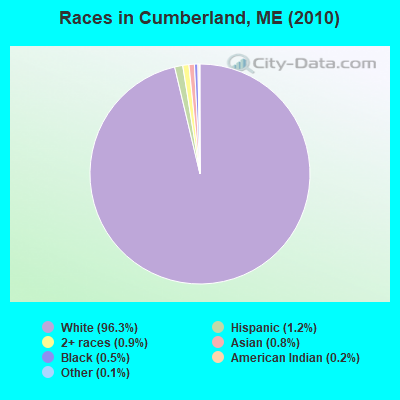
- 6,94796.3%White alone
- 861.2%Hispanic
- 640.9%Two or more races
- 550.8%Asian alone
- 340.5%Black alone
- 140.2%American Indian alone
- 80.1%Other race alone
- 30.04%Native Hawaiian and Other
Pacific Islander alone
Races in Cumberland detailed stats: ancestries, foreign born residents, place of birth
According to our research of Maine and other state lists, there were 4 registered sex offenders living in Cumberland, Maine as of May 09, 2024.
The ratio of all residents to sex offenders in Cumberland is 1,803 to 1.
The ratio of registered sex offenders to all residents in this city is much lower than the state average.
Type |
2009 |
2010 |
2011 |
2012 |
2013 |
2014 |
2015 |
2016 |
2017 |
2018 |
2019 |
2020 |
2021 |
2022 |
|---|---|---|---|---|---|---|---|---|---|---|---|---|---|---|
| Murders (per 100,000) | 0 (0.0) | 0 (0.0) | 0 (0.0) | 0 (0.0) | 0 (0.0) | 0 (0.0) | 0 (0.0) | 0 (0.0) | 0 (0.0) | 0 (0.0) | 0 (0.0) | 0 (0.0) | 0 (0.0) | 0 (0.0) |
| Rapes (per 100,000) | 3 (39.3) | 1 (13.9) | 3 (41.6) | 0 (0.0) | 0 (0.0) | 0 (0.0) | 0 (0.0) | 0 (0.0) | 0 (0.0) | 0 (0.0) | 0 (0.0) | 1 (12.0) | 2 (23.8) | 0 (0.0) |
| Robberies (per 100,000) | 0 (0.0) | 0 (0.0) | 0 (0.0) | 0 (0.0) | 0 (0.0) | 0 (0.0) | 0 (0.0) | 0 (0.0) | 0 (0.0) | 1 (12.1) | 0 (0.0) | 0 (0.0) | 0 (0.0) | 0 (0.0) |
| Assaults (per 100,000) | 1 (13.1) | 2 (27.7) | 3 (41.6) | 2 (27.6) | 1 (13.6) | 1 (13.4) | 0 (0.0) | 1 (12.8) | 0 (0.0) | 1 (12.1) | 0 (0.0) | 2 (24.0) | 1 (11.9) | 0 (0.0) |
| Burglaries (per 100,000) | 13 (170.2) | 14 (194.1) | 11 (152.6) | 10 (138.2) | 11 (149.6) | 6 (80.6) | 6 (78.5) | 4 (51.1) | 5 (62.8) | 5 (60.4) | 2 (24.1) | 0 (0.0) | 3 (35.7) | 0 (0.0) |
| Thefts (per 100,000) | 21 (274.9) | 22 (305.1) | 49 (679.6) | 25 (345.5) | 7 (95.2) | 22 (295.7) | 6 (78.5) | 20 (255.7) | 18 (226.2) | 12 (145.0) | 14 (168.8) | 20 (240.2) | 20 (237.7) | 18 (208.9) |
| Auto thefts (per 100,000) | 2 (26.2) | 0 (0.0) | 1 (13.9) | 3 (41.5) | 1 (13.6) | 1 (13.4) | 6 (78.5) | 0 (0.0) | 1 (12.6) | 0 (0.0) | 1 (12.1) | 1 (12.0) | 2 (23.8) | 0 (0.0) |
| Arson (per 100,000) | 0 (0.0) | 0 (0.0) | 0 (0.0) | 0 (0.0) | 0 (0.0) | 0 (0.0) | 0 (0.0) | 0 (0.0) | 0 (0.0) | 0 (0.0) | 0 (0.0) | 0 (0.0) | 1 (11.9) | 0 (0.0) |
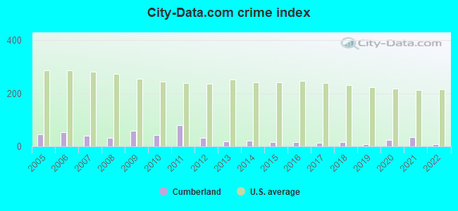
| City-Data.com crime index | 59.0 | 42.4 | 80.6 | 32.3 | 18.1 | 21.2 | 14.9 | 16.4 | 14.5 | 16.1 | 9.4 | 25.0 | 35.3 | 8.4 |
The City-Data.com crime index weighs serious crimes and violent crimes more heavily. Higher means more crime, U.S. average is 246.1. It adjusts for the number of visitors and daily workers commuting into cities.
Crime rate in Cumberland detailed stats: murders, rapes, robberies, assaults, burglaries, thefts, arson
Full-time law enforcement employees in 2021, including police officers: 15 (13 officers - 12 male; 1 female).
| Officers per 1,000 residents here: | 1.54 |
| Maine average: | 1.71 |
 Recent articles from our blog. Our writers, many of them Ph.D. graduates or candidates, create easy-to-read articles on a wide variety of topics.

Cumberland, ME City Guides:
Ancestries: English (28.2%), Irish (15.9%), German (12.1%), Scottish (10.8%), French (9.0%), United States (7.3%).
Current Local Time: EST time zone
Incorporated on 04/02/1822
Land area: 26.1 square miles.
Population density: 277 people per square mile (very low).
202 residents are foreign born (1.3% Asia, 0.9% North America, 0.3% Europe).
| This town: | 2.8% |
| Maine: | 2.9% |
| Cumberland town: | 1.5% ($2,775) |
| Maine: | 1.5% ($1,417) |
Nearest city with pop. 50,000+: Portland, ME  (8.4 miles , pop. 64,249).
Nearest city with pop. 200,000+: Boston, MA (110.1 miles , pop. 589,141).
Nearest city with pop. 1,000,000+: Bronx, NY (275.9 miles , pop. 1,332,650).
Nearest cities:
), ), ), ), ), )Latitude: 43.78 N, Longitude: 70.22 W
Area code: 207
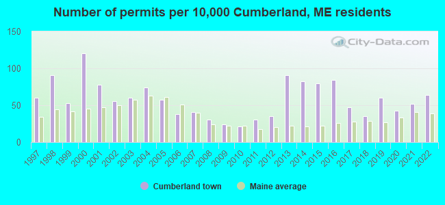
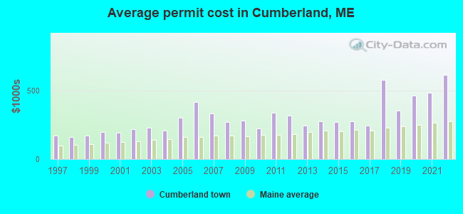
Single-family new house construction building permits:
- 2022: 46 buildings, average cost: $617,400
- 2021: 37 buildings, average cost: $484,900
- 2020: 31 buildings, average cost: $467,100
- 2019: 43 buildings, average cost: $358,200
- 2018: 25 buildings, average cost: $583,100
- 2017: 34 buildings, average cost: $248,000
- 2016: 60 buildings, average cost: $275,300
- 2015: 57 buildings, average cost: $272,400
- 2014: 59 buildings, average cost: $277,600
- 2013: 65 buildings, average cost: $247,800
- 2012: 25 buildings, average cost: $320,000
- 2011: 22 buildings, average cost: $338,200
- 2010: 15 buildings, average cost: $224,300
- 2009: 17 buildings, average cost: $283,100
- 2008: 22 buildings, average cost: $271,600
- 2007: 29 buildings, average cost: $336,600
- 2006: 27 buildings, average cost: $420,100
- 2005: 41 buildings, average cost: $303,600
- 2004: 53 buildings, average cost: $211,300
- 2003: 43 buildings, average cost: $228,100
- 2002: 40 buildings, average cost: $216,700
- 2001: 56 buildings, average cost: $190,900
- 2000: 86 buildings, average cost: $201,300
- 1999: 38 buildings, average cost: $175,300
- 1998: 65 buildings, average cost: $161,600
- 1997: 43 buildings, average cost: $173,100
| Here: | 2.3% |
| Maine: | 3.4% |
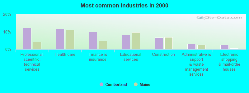
- Professional, scientific, technical services (12.3%)
- Health care (11.6%)
- Finance & insurance (9.9%)
- Educational services (8.1%)
- Construction (6.8%)
- Administrative & support & waste management services (2.9%)
- Electronic shopping & mail-order houses (2.6%)
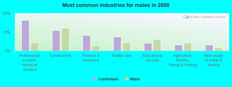
- Professional, scientific, technical services (16.3%)
- Construction (10.8%)
- Finance & insurance (8.2%)
- Health care (7.4%)
- Educational services (4.0%)
- Agriculture, forestry, fishing & hunting (3.0%)
- Real estate & rental & leasing (3.0%)
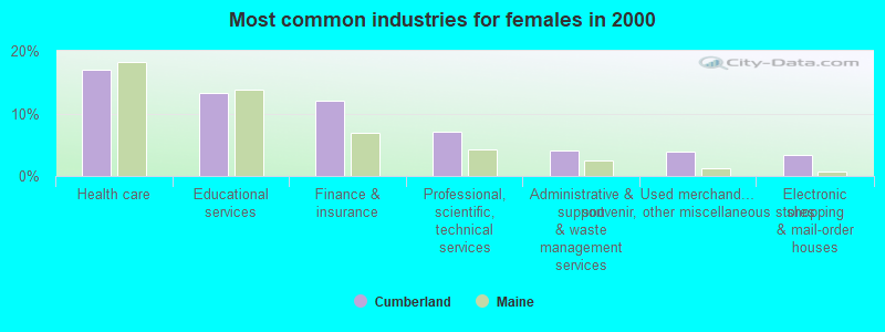
- Health care (17.0%)
- Educational services (13.2%)
- Finance & insurance (12.1%)
- Professional, scientific, technical services (7.2%)
- Administrative & support & waste management services (4.0%)
- Used merchandise, gift, novelty, souvenir, other miscellaneous stores (3.9%)
- Electronic shopping & mail-order houses (3.4%)
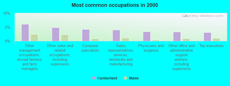
- Other management occupations, except farmers and farm managers (6.1%)
- Other sales and related occupations, including supervisors (4.8%)
- Computer specialists (4.2%)
- Sales representatives, services, wholesale and manufacturing (4.0%)
- Physicians and surgeons (3.4%)
- Other office and administrative support workers, including supervisors (3.3%)
- Top executives (3.1%)
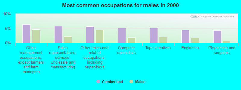
- Other management occupations, except farmers and farm managers (6.4%)
- Sales representatives, services, wholesale and manufacturing (5.8%)
- Other sales and related occupations, including supervisors (5.7%)
- Computer specialists (5.2%)
- Top executives (5.1%)
- Engineers (4.4%)
- Physicians and surgeons (4.3%)

- Registered nurses (6.6%)
- Preschool, kindergarten, elementary, and middle school teachers (6.3%)
- Other management occupations, except farmers and farm managers (5.7%)
- Other office and administrative support workers, including supervisors (5.4%)
- Secretaries and administrative assistants (4.9%)
- Other financial specialists (3.9%)
- Other sales and related occupations, including supervisors (3.7%)
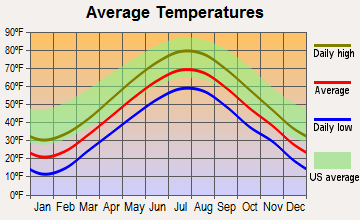
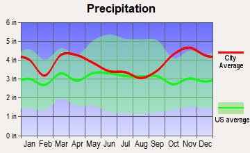
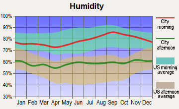
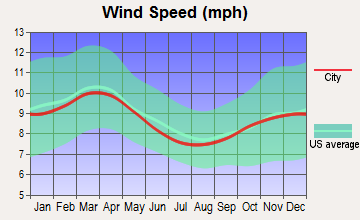
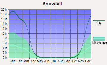
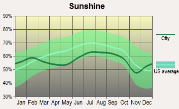
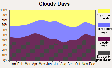
Average climate in Cumberland, Maine
Based on data reported by over 4,000 weather stations
(lower is better)
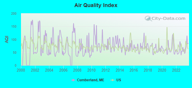
Air Quality Index (AQI) level in 2023 was 70.7. This is about average.
| City: | 70.7 |
| U.S.: | 72.6 |
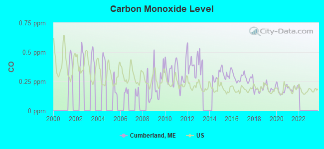
Carbon Monoxide (CO) [ppm] level in 2021 was 0.192. This is better than average. Closest monitor was 8.7 miles away from the city center.
| City: | 0.192 |
| U.S.: | 0.251 |
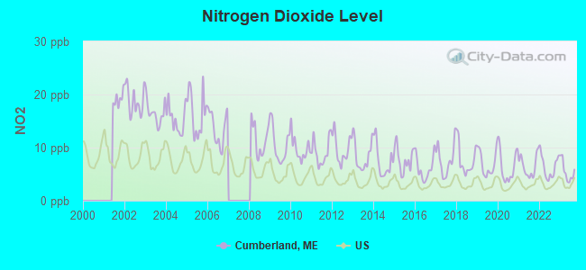
Nitrogen Dioxide (NO2) [ppb] level in 2023 was 5.47. This is about average. Closest monitor was 8.5 miles away from the city center.
| City: | 5.47 |
| U.S.: | 5.11 |
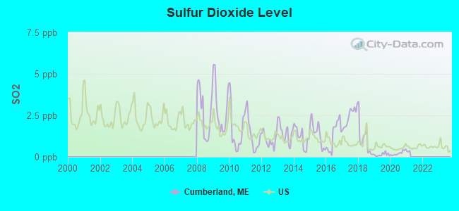
Sulfur Dioxide (SO2) [ppb] level in 2020 was 0.222. This is significantly better than average. Closest monitor was 4.0 miles away from the city center.
| City: | 0.222 |
| U.S.: | 1.515 |
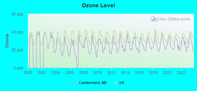
Ozone [ppb] level in 2023 was 29.1. This is about average. Closest monitor was 8.4 miles away from the city center.
| City: | 29.1 |
| U.S.: | 33.3 |
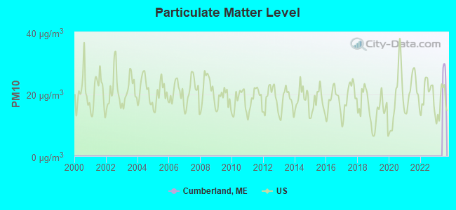
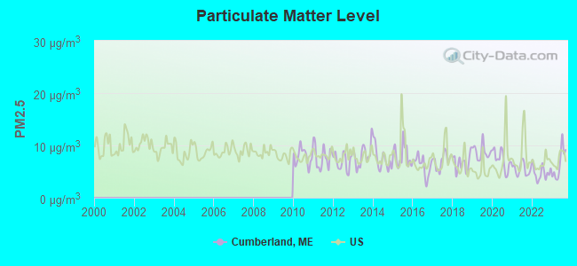
Particulate Matter (PM2.5) [µg/m3] level in 2023 was 6.49. This is better than average. Closest monitor was 7.4 miles away from the city center.
| City: | 6.49 |
| U.S.: | 8.11 |
Tornado activity:
Cumberland-area historical tornado activity is above Maine state average. It is 80% smaller than the overall U.S. average.
On 7/8/1996, a category F2 (max. wind speeds 113-157 mph) tornado 30.6 miles away from the Cumberland town center caused $10,000 in damages.
On 10/10/1966, a category F2 tornado 37.2 miles away from the town center caused between $5000 and $50,000 in damages.
Earthquake activity:
Cumberland-area historical earthquake activity is significantly above Maine state average. It is 75% smaller than the overall U.S. average.On 10/16/2012 at 23:12:25, a magnitude 4.7 (4.7 ML, Depth: 10.0 mi, Class: Light, Intensity: IV - V) earthquake occurred 25.4 miles away from the city center
On 4/20/2002 at 10:50:47, a magnitude 5.3 (5.3 ML, Depth: 3.0 mi, Class: Moderate, Intensity: VI - VII) earthquake occurred 179.9 miles away from Cumberland center
On 1/19/1982 at 00:14:42, a magnitude 4.7 (4.5 MB, 4.7 MD, 4.5 LG) earthquake occurred 71.9 miles away from Cumberland center
On 4/20/2002 at 10:50:47, a magnitude 5.2 (5.2 MB, 4.2 MS, 5.2 MW, 5.0 MW) earthquake occurred 180.5 miles away from Cumberland center
On 10/7/1983 at 10:18:46, a magnitude 5.3 (5.1 MB, 5.3 LG, 5.1 ML) earthquake occurred 206.0 miles away from the city center
On 2/26/1999 at 03:38:43, a magnitude 3.8 (3.8 LG, Depth: 2.0 mi, Class: Light, Intensity: II - III) earthquake occurred 59.5 miles away from Cumberland center
Magnitude types: regional Lg-wave magnitude (LG), body-wave magnitude (MB), duration magnitude (MD), local magnitude (ML), surface-wave magnitude (MS), moment magnitude (MW)
Natural disasters:
The number of natural disasters in Cumberland County (33) is a lot greater than the US average (15).Major Disasters (Presidential) Declared: 22
Emergencies Declared: 10
Causes of natural disasters: Floods: 19, Storms: 13, Snows: 7, Winter Storms: 6, Heavy Rains: 3, Hurricanes: 3, Winds: 3, Blizzard: 1, Ice Storm: 1, Mudslide: 1, Snowfall: 1, Snowstorm: 1, Tornado: 1, Other: 2 (Note: some incidents may be assigned to more than one category).
Hospitals and medical centers near Cumberland:
- BRENTWOOD REHAB AND NURSING CENTER (Nursing Home, about 2 miles away; YARMOUTH, ME)
- SEDGEWOOD COMMONS (Nursing Home, about 4 miles away; FALMOUTH, ME)
- FALMOUTH BY THE SEA (Nursing Home, about 4 miles away; FALMOUTH, ME)
- ST JOSEPH'S REHABILITATION AND RESIDENCE (Nursing Home, about 7 miles away; PORTLAND, ME)
- CHS - HOSPICE (Hospital, about 8 miles away; PORTLAND, ME)
- SEASIDE REHAB AND HEALTH CARE (Nursing Home, about 8 miles away; PORTLAND, ME)
- GENTIVA HEALTH SERVICES - PORTLAND (Home Health Center, about 9 miles away; PORTLAND, ME)
located in Cumberland:
Colleges/universities with over 2000 students nearest to Cumberland:
- University of Southern Maine (about 9 miles; Portland, ME; Full-time enrollment: 6,647)
- Southern Maine Community College (about 10 miles; South Portland, ME; FT enrollment: 4,666)
- Saint Joseph's College of Maine (about 14 miles; Standish, ME; FT enrollment: 2,010)
- University of New England (about 24 miles; Biddeford, ME; FT enrollment: 4,539)
- University of Maine at Augusta (about 44 miles; Augusta, ME; FT enrollment: 3,204)
- University of New Hampshire-Main Campus (about 58 miles; Durham, NH; FT enrollment: 15,243)
- University of Maine at Farmington (about 62 miles; Farmington, ME; FT enrollment: 2,036)
Points of interest:
Notable locations in Cumberland: Cumberland Farmers Club (A), Great Chebeague Golf Club (B), Chebeague Island Rescue Station (C), Chebeague Island Fire Department (D), Cumberland Rescue Department (E), Chebeague Island Library (F), Cumberland Town Hall (G), Cumberland Fire Department West Station (H), Cumberland Fire Department Central Station (I). Display/hide their locations on the map
Churches in Cumberland include: Holy Martyrs Church (A), West Cumberland United Methodist Church (B), Tuttle Road United Methodist Church (C). Display/hide their locations on the map
Cemeteries: Farris Cemetery (1), West Cumberland Church Cemetery (2), Moss Side Cemetery (3). Display/hide their locations on the map
Lakes and reservoirs: Blanchard Pond (A), Knights Pond (B). Display/hide their locations on the map
Streams, rivers, and creeks: Maxfield Brook (A), Mill Brook (B), Windle Brook (C). Display/hide their locations on the map
Park in Cumberland: Wildwood Park (1). Display/hide its location on the map
| This town: | 2.7 people |
| Maine: | 2.3 people |
| This town: | 77.1% |
| Whole state: | 62.9% |
| This town: | 4.4% |
| Whole state: | 9.4% |
Likely homosexual households (counted as self-reported same-sex unmarried-partner households)
- Lesbian couples: 0.3% of all households
- Gay men: 0.4% of all households
| This town: | 3.0% |
| Whole state: | 10.9% |
| This town: | 1.8% |
| Whole state: | 4.1% |
For population 15 years and over in Cumberland:
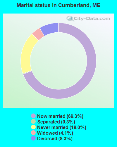
- Never married: 18.0%
- Now married: 69.3%
- Separated: 0.3%
- Widowed: 4.1%
- Divorced: 8.3%
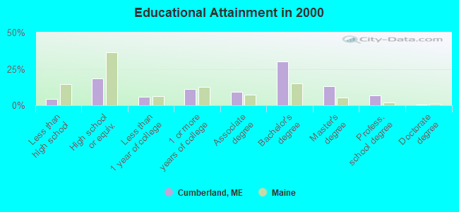
For population 25 years and over in Cumberland:
- High school or higher: 95.5%
- Bachelor's degree or higher: 50.3%
- Graduate or professional degree: 20.3%
- Unemployed: 3.3%
- Mean travel time to work (commute): 23.4 minutes
| Here: | 9.8 |
| Maine average: | 11.2 |
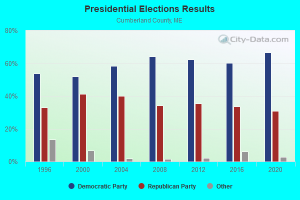
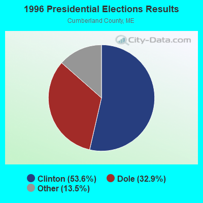
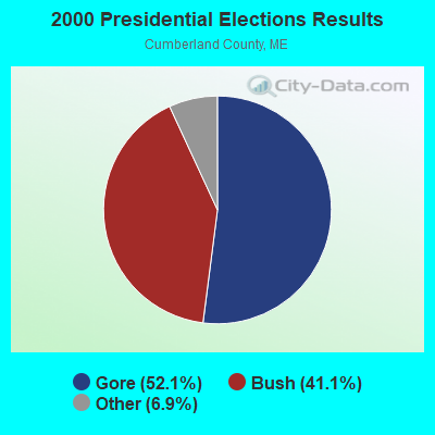
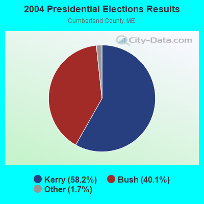
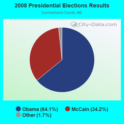
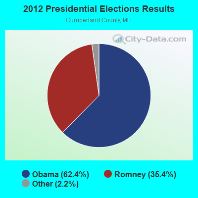

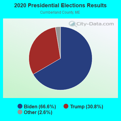
Graphs represent county-level data. Detailed 2008 Election Results
Religion statistics for Cumberland, ME (based on Cumberland County data)
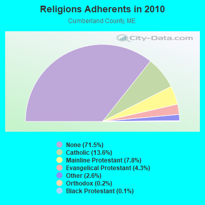
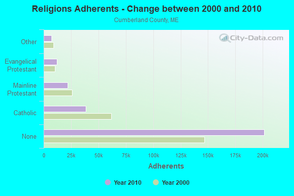
| Religion | Adherents | Congregations |
|---|---|---|
| Catholic | 38,243 | 19 |
| Mainline Protestant | 22,030 | 96 |
| Evangelical Protestant | 12,007 | 85 |
| Other | 7,187 | 44 |
| Orthodox | 500 | 1 |
| Black Protestant | 285 | 2 |
| None | 201,422 | - |
Food Environment Statistics:
| Here: | 2.62 / 10,000 pop. |
| Maine: | 2.80 / 10,000 pop. |
| Cumberland County: | 0.11 / 10,000 pop. |
| State: | 0.14 / 10,000 pop. |
| Here: | 2.44 / 10,000 pop. |
| State: | 2.20 / 10,000 pop. |
| This county: | 3.82 / 10,000 pop. |
| State: | 5.75 / 10,000 pop. |
| Here: | 12.01 / 10,000 pop. |
| State: | 11.02 / 10,000 pop. |
| Cumberland County: | 7.1% |
| Maine: | 8.2% |
| Cumberland County: | 19.5% |
| Maine: | 25.0% |
Strongest AM radio stations in Cumberland:
- WGAN (560 AM; 5 kW; PORTLAND, ME; Owner: SAGA COMMUNICATIONS OF NEW ENGLAND, LLC)
- WLOB (1310 AM; 5 kW; PORTLAND, ME; Owner: ATLANTIC COAST RADIO, LLC)
- WMTW (870 AM; 10 kW; GORHAM, ME; Owner: RADIO PARTNERS OF MAINE, L.P.)
- WJAE (1440 AM; 5 kW; WESTBROOK, ME; Owner: ALTANTIC COAST RADIO, LLC)
- WZAN (970 AM; 5 kW; PORTLAND, ME; Owner: SAGA COMMUNICATIONS OF NEW ENGLAND, LLC)
- WBAE (1490 AM; 1 kW; PORTLAND, ME; Owner: SAGA COMMUNICATIONS OF NEW ENGLAND, LLC)
- WLAM (1470 AM; 5 kW; LEWISTON, ME; Owner: RADIO PARTNERS OF MAINE, L.P.)
- WRKO (680 AM; 50 kW; BOSTON, MA; Owner: ENTERCOM BOSTON LICENSE, LLC)
- WJJB (900 AM; 1 kW; BRUNSWICK, ME; Owner: ATLANTIC COAST RADIO, LLC)
- WTME (780 AM; 10 kW; RUMFORD, ME; Owner: MOUNTAIN VALLEY BROADCASTING, INC.)
- WGIN (930 AM; 10 kW; ROCHESTER, NH; Owner: CAPSTAR TX LIMITED PARTNERSHIP)
- WEEI (850 AM; 50 kW; BOSTON, MA; Owner: ENTERCOM BOSTON LICENSE, LLC)
- WBZ (1030 AM; 50 kW; BOSTON, MA; Owner: INFINITY BROADCASTING OPERATIONS, INC.)
Strongest FM radio stations in Cumberland:
- WPOR (101.9 FM; PORTLAND, ME; Owner: SAGA COMMUNICATIONS OF NEW ENGLAND, LLC)
- WJBQ (97.9 FM; PORTLAND, ME; Owner: CITADEL BROADCASTING COMPANY)
- WMSJ (89.3 FM; FREEPORT, ME; Owner: DOWNEAST CHRISTIAN COMMUNICATIONS)
- WMTW-FM (106.7 FM; NORTH WINDHAM, ME; Owner: RADIO PARTNERS OF MAINE, L.P.)
- WMGX (93.1 FM; PORTLAND, ME; Owner: SAGA COMMUNICATIONS OF NEW ENGLAND, LLC)
- WBLM (102.9 FM; PORTLAND, ME; Owner: CITADEL BROADCASTING COMPANY)
- WTHT (107.5 FM; LEWISTON, ME; Owner: RADIO PARTNERS OF MAINE, L.P.)
- WMEA (90.1 FM; PORTLAND, ME; Owner: MAINE PUBLIC BROADCASTING CORPORATION)
- WYNZ (100.9 FM; WESTBROOK, ME; Owner: SAGA COMMUNICATIONS OF NEW ENGLAND, LLC)
- WMEK-FM (99.9 FM; AUBURN, ME; Owner: RADIO PARTNERS OF MAINE, L.P.)
- WJJB-FM (95.5 FM; TOPSHAM, ME; Owner: ATLANTIC COAST RADIO, LLC)
- WPKQ (103.7 FM; NORTH CONWAY, NH; Owner: CITADEL BROADCASTING COMPANY)
- WHOM (94.9 FM; MT. WASHINGTON, NH; Owner: CITADEL BROADCASTING COMPANY)
- WCLZ (98.9 FM; BRUNSWICK, ME; Owner: CITADEL BROADCASTING COMPANY)
- WYFP (91.9 FM; HARPSWELL, ME; Owner: BIBLE BROADCASTING NETWORK, INC.)
- W245AA (96.9 FM; PORTLAND, ME; Owner: RADIO PARTNERS OF MAINE, L.P.)
- WSCY (106.9 FM; MOULTONBOROUGH, NH; Owner: NORTHEAST COMMUNICATIONS CORPORATION)
- WCYY (94.3 FM; BIDDEFORD, ME; Owner: CITADEL BROADCASTING COMPANY)
- WRED (95.9 FM; SACO, ME; Owner: ATLANTIC COAST RADIO, LLC)
- WBQW (106.3 FM; SCARBOROUGH, ME; Owner: MARINER BROADCASTING LIMITED PARTNER)
TV broadcast stations around Cumberland:
- WPXT (Channel 51; PORTLAND, ME; Owner: HMW, INC.)
- WPME (Channel 35; LEWISTON, ME; Owner: KB PRIME MEDIA LLC)
- WGME-TV (Channel 13; PORTLAND, ME; Owner: WGME LICENSEE, LLC)
- W32CA (Channel 32; PORTLAND, ME; Owner: NATIONAL MINORITY T.V., INC.)
- W58CM (Channel 58; BANGOR, ME; Owner: MS COMMUNICATIONS, LLC)
- W57AP (Channel 57; FALMOUTH, ME; Owner: SHERWOOD H. CRAIG)
- WMTW-TV (Channel 8; POLAND SPRING, ME; Owner: WMTW BROADCAST GROUP, LLC)
- WCSH (Channel 6; PORTLAND, ME; Owner: PACIFIC AND SOUTHERN COMPANY, INC.)
- WMEA-TV (Channel 26; BIDDEFORD, ME; Owner: MAINE PUBLIC BROADCASTING CORP.)
- WLLB-LP (Channel 15; PORTLAND, ME; Owner: CARTER BROADCASTING CORPORATION)
- WPFO (Channel 23; WATERVILLE, ME; Owner: CMCG PORTLAND LICENSE LLC)
- WCBB (Channel 10; AUGUSTA, ME; Owner: MAINE PUBLIC BROADCASTING CORP.)
- National Bridge Inventory (NBI) Statistics
- 3Number of bridges
- 52ft / 16.3mTotal length
- 14,649Total average daily traffic
- 731Total average daily truck traffic
- 20,509Total future (year 2036) average daily traffic
FCC Registered Cell Phone Towers:
1- Rangeway Rd.; 2.8 Mi Sse Of Cumberland Center (Lat: 43.763694 Lon: -70.229500), Type: Tower, Structure height: 57.9 m, Call Sign: KNKQ459
Assigned Frequencies: 880.020 MHz, 880.020 MHz, 880.020 MHz, 835.020 MHz, 835.020 MHz, 835.020 MHz, 891.510 MHz, 891.510 MHz, 891.510 MHz, 846.510 MHz, 846.510 MHz, 846.510 MHzGrant Date: 12/11/2018, Expiration Date: 01/15/2029, Certifier: Gregory M RomanoRegistrant: Verizon, 1300 I Street Nw - Suite 500 East, Washington, DC 20005, Phone: (202) 515-2453, Email:
FCC Registered Antenna Towers:
5- Steven P Cowan, Lat: 43.651111 Lon: -70.310333, Type: 22.9, Overall height: 22.9 m, Registrant: Embassy Suites, Portl-and, Phone: (207) 775-2200
- STEVEN P COWAN, Lat: 43.651111 Lon: -70.310333, Type: 22.9, Overall height: 22.9 m, Registrant: Embassy Suites, Portl-and, Phone: (207) 775-2200
- Edward G Roach, Range Road (Lat: 43.763556 Lon: -70.229750), Type: 61.0, Overall height: 54.8 m, Registrant: Sba Properties, Inc., Eroach@sbasite.Com, , Boca -Raton, Phone: (561) 995-7670
- Edward G Roach, Range Road (Lat: 43.763556 Lon: -70.229750), Type: 61.0, Overall height: 54.8 m, Registrant: Sba Properties, Inc., Eroach@sbasite.Com, , Boca -Raton, Phone: (561) 995-7670
- Edward G Roach, Range Road (Lat: 43.763556 Lon: -70.229750), Type: 61.0, Structure height: 23005 m, Overall height: 54.8 m, Registrant: Sba Properties, LLC, Eroach@sbasite.Com, , Boca -Raton, Phone: (561) 995-7670
FCC Registered Broadcast Land Mobile Towers:
11 (See the full list of FCC Registered Broadcast Land Mobile Towers in Cumberland, ME)FCC Registered Microwave Towers:
2- CUMBERLAND, Rangeway Rd (Lat: 43.763667 Lon: -70.229472), Type: Tower, Structure height: 48.8 m, Call Sign: WMS648,
Assigned Frequencies: 6615.00 MHz, Grant Date: 02/15/2011, Expiration Date: 02/01/2021, Cancellation Date: 08/04/2015, Registrant: Verizon Wireless, 1120 Sanctuary Pkwy, #150 Gasa5reg, Alpharetta, GA 30009-7630, Phone: (770) 797-1070, Fax: (770) 797-1036, Email:
- CUMBERLAND, 1.5 Miles Ese Of (Lat: 43.763667 Lon: -70.229472), Overall height: 42.7 m, Call Sign: WHQ511,
Assigned Frequencies: 5945.20 MHz, 5945.20 MHz, 5974.85 MHz, 6093.45 MHz, 11405.0 MHz, 11525.0 MHz, 6004.50 MHz, 6004.50 MHz, 6093.45 MHz, 11485.0 MHz... (+3 more), Grant Date: 04/24/1987, Expiration Date: 10/17/1996, Cancellation Date: 10/17/1996, Registrant: New England Telephone And Telegraph Company, 125 High St Rm 515, Boston, MA 02110
FCC Registered Maritime Coast & Aviation Ground Towers:
2- Chandler Cove Chebeague Island (Lat: 43.715639 Lon: -70.125056), Type: Building, Overall height: 5 m, Call Sign: WHW399, Licensee ID: L00001341,
Assigned Frequencies: 156.450 MHz, 156.800 MHz, 156.950 MHz, Grant Date: 03/29/1994, Expiration Date: 03/29/1999, Cancellation Date: 05/06/2001, Registrant: Chebeague Transportation Company, 315a Cousins Island Rd, Yarmouth, ME 04096
- 37 South Rd Chebeague Island (Lat: 43.737583 Lon: -70.110056), Type: Building, Overall height: 8 m, Call Sign: WHW662, Licensee ID: L00001341,
Assigned Frequencies: 156.450 MHz, 156.800 MHz, 156.950 MHz, Grant Date: 03/29/1994, Expiration Date: 03/29/1999, Cancellation Date: 05/06/2001, Registrant: Chebeague Transportation Company, 315a Cousin Island Rd, Yarmouth, ME 04096
FCC Registered Amateur Radio Licenses:
22 (See the full list of FCC Registered Amateur Radio Licenses in Cumberland)FAA Registered Aircraft:
7- Aircraft: GLOBE GC-1B (Category: Land, Seats: 2, Weight: Up to 12,499 Pounds, Speed: 105 mph), Engine: AEROSPORT O-360-A1A (180 HP) (Reciprocating)
N-Number: 3271K, N3271K, N-3271K, Serial Number: 1264, Year manufactured: 1946, Airworthiness Date: 07/26/2016, Certificate Issue Date: 12/15/2014
Registrant (Individual): Reginald B Cameron, Po Box 4, Cumberland, ME 04021 - Aircraft: PIPER PA-28R-200 (Category: Land, Seats: 4, Weight: Up to 12,499 Pounds, Speed: 107 mph), Engine: LYCOMING I0360 SER (180 HP) (Reciprocating)
N-Number: 41207, N41207, N-41207, Serial Number: 28R-7435154, Year manufactured: 1974, Airworthiness Date: 01/08/1974, Certificate Issue Date: 02/09/2015
Registrant (Individual): Gary H Readio, 24 Pond Shore Dr, Cumberland, ME 04021 - Aircraft: CESSNA T206H (Category: Land, Seats: 6, Weight: Up to 12,499 Pounds), Engine: LYCOMING TIO-540-AJ1A (310 HP) (Reciprocating)
N-Number: 4169W, N4169W, N-4169W, Serial Number: T20609154, Year manufactured: 2014, Airworthiness Date: 12/22/2014, Certificate Issue Date: 01/14/2015
Registrant (Corporation): Sebago Flight Service Inc, 25 Shady Run Ln, Cumberland, ME 04021 - Aircraft: CESSNA 172 (Category: Land, Seats: 4, Weight: Up to 12,499 Pounds, Speed: 105 mph), Engine: CONT MOTOR 0-300 SER (145 HP) (Reciprocating)
N-Number: 6156E, N6156E, N-6156E, Serial Number: 46256, Year manufactured: 1958, Airworthiness Date: 11/14/1958, Certificate Issue Date: 01/14/1984
Registrant (Individual): John W Paynter, 445 Greely Rd, Cumberland, ME 04021 - Aircraft: HEWETT JAY C SONEX (Category: Land, Seats: 2, Weight: Up to 12,499 Pounds), Engine: SONEX ACFT AEROVEE TURBO (100 HP) (Reciprocating)
N-Number: 868SX, N868SX, N-868SX, Serial Number: 1650, Year manufactured: 2019, Airworthiness Date: 05/29/2019, Certificate Issue Date: 06/05/2018
Registrant (Individual): Jay C Hewett, 37 Shady Run Ln, Cumberland, ME 04021 - Aircraft: J&J ULTRALIGHTS SEA WING (Category: Land, Seats: 2, Weight: Up to 12,499 Pounds), Engine: ROTAX 582UL-99 (65 HP) (2 Cycle)
N-Number: 947WL, N947WL, N-947WL, Serial Number: SWJ582105001, Year manufactured: 1999, Airworthiness Date: 01/20/2010, Certificate Issue Date: 05/29/2007
Registrant (Individual): William E Lewis, 140 Middle Rd, Cumberland, ME 04021 - Aircraft: LYNCH JAMES E TEENIE TWO (Category: Land, Weight: Up to 12,499 Pounds), Engine: VOLKSWAGEN CONVERSION (36 HP) (4 Cycle)
N-Number: 137JL, N137JL, N-137JL, Serial Number: 16-161, Year manufactured: 2013, Airworthiness Date: 12/05/2013, Certificate Issue Date: 08/06/2013
Registrant (Individual): James E Lynch, 7 Blackstrap Rd, Cumberland, ME 04021
Deregistered: Cancel Date: 11/29/2019
2003 - 2018 National Fire Incident Reporting System (NFIRS) incidents
- Fire incident types reported to NFIRS in Cumberland, ME
- 19857.6%Structure Fires
- 7120.6%Outside Fires
- 5917.2%Mobile Property/Vehicle Fires
- 164.7%Other
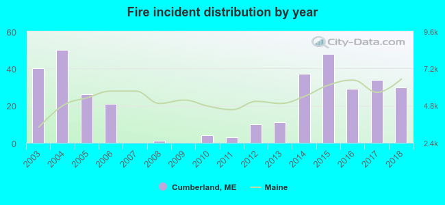 Based on the data from the years 2003 - 2018 the average number of fires per year is 22. The highest number of reported fires - 50 took place in 2004, and the least - 0 in 2007. The data has a decreasing trend.
 When looking into fire subcategories, the most reports belonged to: Structure Fires (57.6%), and Outside Fires (20.6%).
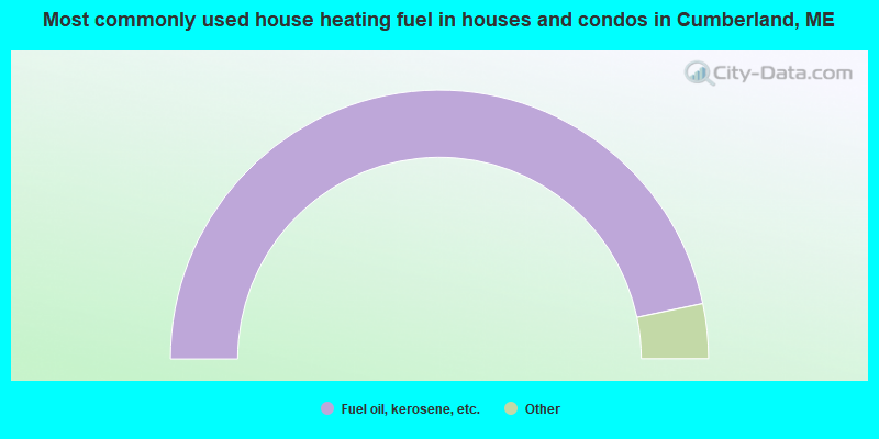
- 93.4%Fuel oil, kerosene, etc.
- 3.6%Wood
- 2.3%Bottled, tank, or LP gas
- 0.4%Coal or coke
- 0.3%Electricity
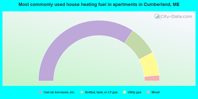
- 68.8%Fuel oil, kerosene, etc.
- 15.6%Bottled, tank, or LP gas
- 12.6%Utility gas
- 3.0%Wood
Cumberland compared to Maine state average:
- Median household income above state average.
- Median house value above state average.
- Unemployed percentage significantly below state average.
- Black race population percentage significantly below state average.
- Hispanic race population percentage below state average.
- Renting percentage significantly below state average.
- Length of stay since moving in significantly above state average.
- Number of rooms per house significantly below state average.
- House age significantly below state average.
- Number of college students below state average.
- Percentage of population with a bachelor's degree or higher above state average.
Cumberland on our top lists:
- #2 on the list of "Top 101 cities with largest percentage of females in industries: electronic shopping and mail-order houses (population 5,000+)"
- #3 on the list of "Top 101 cities with largest percentage of females in occupations: other financial specialists (population 5,000+)"
- #5 on the list of "Top 101 cities with largest percentage of males in occupations: financial managers (population 5,000+)"
- #7 on the list of "Top 101 cities with largest percentage of males in industries: electronic shopping and mail-order houses (population 5,000+)"
- #12 on the list of "Top 101 cities with the largest city-data.com crime index decrease from 2011 to 2012 (population 5,000+)"
- #14 on the list of "Top 101 cities with largest percentage of males in industries: water transportation (population 5,000+)"
- #15 on the list of "Top 101 cities with largest percentage of females in industries: used merchandise, gift, novelty, and souvenir, and other miscellaneous stores (population 5,000+)"
- #18 on the list of "Top 101 cities with largest percentage of females in occupations: physicians and surgeons (population 5,000+)"
- #20 on the list of "Top 101 cities with largest percentage of females in occupations: lawyers (population 5,000+)"
- #22 on the list of "Top 100 safest cities (lowest city-data.com crime index) (pop. 5,000+)"
- #24 on the list of "Top 101 cities with largest percentage of females in industries: retail florists (population 5,000+)"
- #26 on the list of "Top 101 cities with largest percentage of females in occupations: fishing and hunting, and forest and logging workers (population 5,000+)"
- #27 on the list of "Top 101 cities with largest percentage of males in occupations: physicians and surgeons (population 5,000+)"
- #35 on the list of "Top 101 cities with largest percentage of females in industries: printing and related support activities (population 5,000+)"
- #39 on the list of "Top 101 cities with largest percentage of males in industries: lumber and other construction materials merchant wholesalers (population 5,000+)"
- #43 on the list of "Top 101 cities with largest percentage of females in industries: professional and commercial equipment and supplies merchant wholesalers (population 5,000+)"
- #48 on the list of "Top 101 cities with largest percentage of females in industries: water transportation (population 5,000+)"
- #52 on the list of "Top 101 cities with largest percentage of females in industries: leather and allied products (population 5,000+)"
- #54 on the list of "Top 101 cities with largest percentage of males in industries: data processing, libraries, and other information services (population 5,000+)"
- #55 on the list of "Top 101 cities with largest percentage of females in industries: wood products (population 5,000+)"
- #28 on the list of "Top 101 counties with the highest percentage of residents that exercised in the past month"
- #30 on the list of "Top 101 counties with the best general health status score of residents (1-5), 3 years of data"
- #40 on the list of "Top 101 counties with the highest percentage of residents that visited a dentist within the past year"
- #43 on the list of "Top 101 counties with the highest Nitrogen Dioxide air pollution readings in 2012 (ppm)"
- #49 on the list of "Top 101 counties with the lowest number of births per 1000 residents 2007-2013"

|
|
Total of 60 patent applications in 2008-2024.