Corinth, Maine
Submit your own pictures of this town and show them to the world
- OSM Map
- Google Map
- MSN Map
Population change since 2000: +14.6%
 |
| Males: 1,406 | |
| Females: 1,472 |
| Median resident age: | 40.4 years |
| Maine median age: | 43.0 years |
Zip codes: 04427.
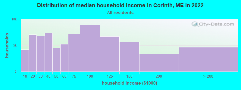
| Corinth: | $66,564 |
| ME: | $69,543 |
Estimated per capita income in 2022: $33,089 (it was $16,460 in 2000)
Corinth town income, earnings, and wages data
Estimated median house or condo value in 2022: $197,497 (it was $75,900 in 2000)
| Corinth: | $197,497 |
| ME: | $290,600 |
Mean prices in 2022: all housing units: $235,563; detached houses: $252,705; townhouses or other attached units: $267,749; in 2-unit structures: $255,332; in 3-to-4-unit structures: $815,300; in 5-or-more-unit structures: $185,873; mobile homes: $93,017; occupied boats, rvs, vans, etc.: $21,333
Detailed information about poverty and poor residents in Corinth, ME
Compare current foreclosures near Corinth, ME:
| Photo | Address | Area | Beds / Baths | Price | Details |
|---|---|---|---|---|---|

|
#1
Main St
Corinth, ME 04427
|
1,573 sq. feet
|
2 baths 3 beds |
show details | |

|
#2
W Corinth Rd
Corinth, ME 04427
|
1,440 sq. feet
|
2 baths - beds |
show details | |

|
#3
Exeter Rd
Corinth, ME 04427
|
- sq. feet
|
- baths - beds |
show details | |

|
#4
Morison Ave
Corinth, ME 04427
|
- sq. feet
|
- baths - beds |
show details | |

|
#5
Pier St
Bangor, ME 04401
|
2,000 sq. feet
|
2 baths 4 beds |
$89,900
|
show details |

|
#6
Hudson Rd
Corinth, ME 04427
|
- sq. feet
|
- baths - beds |
show details | |

|
#7
Bog Rd
Hampden, ME 04444
|
1,512 sq. feet
|
3 baths 5 beds |
show details | |

|
#8
Sugarloaf Ln
Bangor, ME 04401
|
1,421 sq. feet
|
2 baths 3 beds |
show details | |

|
#9
Newport Rd
Corinna, ME 04928
|
756 sq. feet
|
1 baths 3 beds |
show details | |

|
#10
Randolph Dr
Bangor, ME 04401
|
1,350 sq. feet
|
2 baths 4 beds |
show details |
| Photo | Address | Area | Beds / Baths | Price | Details |
|---|---|---|---|---|---|

|
#11
Maxwell Ln
Bangor, ME 04401
|
1,450 sq. feet
|
1 baths 3 beds |
show details | |

|
#12
Union St
Bangor, ME 04401
|
1,857 sq. feet
|
2 baths 3 beds |
show details | |

|
#13
Bennoch Rd
Old Town, ME 04468
|
1,244 sq. feet
|
3 baths 4 beds |
show details | |

|
#14
Savage St
Bangor, ME 04401
|
1,582 sq. feet
|
2 baths 4 beds |
show details | |

|
#15
Cottage St
Bangor, ME 04401
|
960 sq. feet
|
1 baths 3 beds |
show details | |

|
#16
Prentiss St
Bangor, ME 04401
|
1,897 sq. feet
|
1 baths 3 beds |
show details | |

|
#17
Billings Rd
Bangor, ME 04401
|
864 sq. feet
|
2 baths 4 beds |
show details | |

|
#18
Bowdoin St
Bangor, ME 04401
|
1,281 sq. feet
|
1 baths 3 beds |
show details | |

|
#19
Maple St
Bangor, ME 04401
|
1,926 sq. feet
|
3 baths 4 beds |
show details | |

|
#20
Ohio St
Bangor, ME 04401
|
1,628 sq. feet
|
1 baths 4 beds |
show details |
| Photo | Address | Area | Beds / Baths | Price | Details |
|---|---|---|---|---|---|

|
#21
Fruit St
Bangor, ME 04401
|
1,224 sq. feet
|
1 baths 2 beds |
show details | |

|
#22
Elm St
Newport, ME 04953
|
1,632 sq. feet
|
2 baths 5 beds |
show details | |

|
#23
Fuller Rd
Bangor, ME 04401
|
864 sq. feet
|
1 baths 3 beds |
show details | |

|
#24
Smokey Ln
Bangor, ME 04401
|
2,434 sq. feet
|
3 baths 3 beds |
show details | |

|
#25
Kirkland Rd
Old Town, ME 04468
|
864 sq. feet
|
1 baths 2 beds |
show details | |

|
#26
Wing Rd
Bangor, ME 04401
|
1,680 sq. feet
|
2 baths 3 beds |
show details | |

|
#27
Union St
Levant, ME 04456
|
1,538 sq. feet
|
1 baths 4 beds |
show details | |

|
#28
Foxtail Ln
Levant, ME 04456
|
1,190 sq. feet
|
2 baths 3 beds |
show details | |

|
#29
Carter Ave
Newport, ME 04953
|
854 sq. feet
|
1 baths 2 beds |
show details | |

|
#30
Billings Rd
Bangor, ME 04401
|
1,512 sq. feet
|
2 baths 3 beds |
show details |
| Photo | Address | Area | Beds / Baths | Price | Details |
|---|---|---|---|---|---|

|
#31
Thornton Rd
Bangor, ME 04401
|
1,220 sq. feet
|
1 baths 3 beds |
show details | |

|
#32
Grove St
Bangor, ME 04401
|
910 sq. feet
|
1 baths 3 beds |
show details | |

|
#33
Allen St
Bangor, ME 04401
|
1,200 sq. feet
|
1 baths 3 beds |
show details | |

|
#34
Elm St
Bangor, ME 04401
|
- sq. feet
|
2 baths 4 beds |
show details | |

|
#35
Grist Mill Rd
Carmel, ME 04419
|
- sq. feet
|
- baths - beds |
show details | |

|
#36
Broadway
Kenduskeag, ME 04450
|
- sq. feet
|
- baths - beds |
show details | |

|
#37
Cedar St Apt 4
Bangor, ME 04401
|
- sq. feet
|
- baths - beds |
show details | |

|
#38
Union St Apt 1
Bangor, ME 04401
|
- sq. feet
|
- baths - beds |
show details | |

|
#39
Ohio St # 7
Bangor, ME 04401
|
- sq. feet
|
- baths - beds |
show details | |

|
#40
Stillwater Ave
Bangor, ME 04401
|
- sq. feet
|
- baths - beds |
show details |
| Photo | Address | Area | Beds / Baths | Price | Details |
|---|---|---|---|---|---|

|
#41
Union St
Bangor, ME 04401
|
924 sq. feet
|
- baths - beds |
show details | |

|
#42
Storer Rd
Bradford, ME 04410
|
2,013 sq. feet
|
- baths - beds |
show details | |

|
#43
Greeley Rd
Garland, ME 04939
|
- sq. feet
|
- baths - beds |
show details | |

|
#44
Coldbrook Rd
Bangor, ME 04401
|
- sq. feet
|
- baths - beds |
show details | |

|
#45
Ash Ln
Bangor, ME 04401
|
- sq. feet
|
- baths - beds |
show details | |

|
#46
Luckys Landing Rd
Bangor, ME 04401
|
- sq. feet
|
- baths - beds |
show details | |

|
#47
Hudson Rd
Hudson, ME 04449
|
- sq. feet
|
- baths - beds |
show details | |

|
#48
Old Town Rd
Hudson, ME 04449
|
- sq. feet
|
- baths - beds |
show details | |

|
#49
Cedar Breeze N
Bangor, ME 04401
|
- sq. feet
|
- baths - beds |
show details | |

|
Check over 1 million property listings on Foreclosure.com!
|
browse all offers | |||

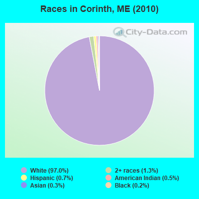
- 2,79197.0%White alone
- 371.3%Two or more races
- 200.7%Hispanic
- 140.5%American Indian alone
- 100.3%Asian alone
- 60.2%Black alone
Races in Corinth detailed stats: ancestries, foreign born residents, place of birth
According to our research of Maine and other state lists, there were 5 registered sex offenders living in Corinth, Maine as of July 03, 2024.
The ratio of all residents to sex offenders in Corinth is 576 to 1.
The ratio of registered sex offenders to all residents in this city is near the state average.
 Recent articles from our blog. Our writers, many of them Ph.D. graduates or candidates, create easy-to-read articles on a wide variety of topics.
Ancestries: United States (18.1%), English (16.7%), Irish (14.5%), French (12.5%), German (6.6%), French Canadian (6.1%).
Current Local Time: EST time zone
Incorporated on 06/21/1811
Land area: 40.2 square miles.
Population density: 72 people per square mile (very low).
27 residents are foreign born
| This town: | 1.1% |
| Maine: | 2.9% |
| Corinth town: | 0.9% ($702) |
| Maine: | 1.5% ($1,417) |
Nearest city with pop. 50,000+: Portland, ME  (110.9 miles , pop. 64,249).
Nearest city with pop. 200,000+: Boston, MA (211.9 miles , pop. 589,141).
Nearest city with pop. 1,000,000+: Bronx, NY (377.9 miles , pop. 1,332,650).
Nearest cities:
), ), ), ), ), )Latitude: 44.99 N, Longitude: 69.00 W
Area code: 207
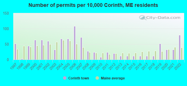
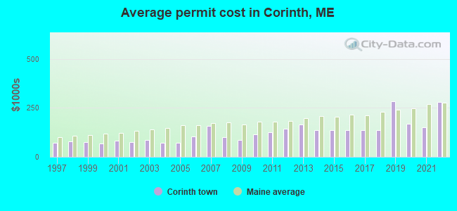
Single-family new house construction building permits:
- 2022: 20 buildings, average cost: $279,200
- 2021: 8 buildings, average cost: $150,000
- 2020: 8 buildings, average cost: $168,800
- 2019: 13 buildings, average cost: $282,200
- 2018: 3 buildings, average cost: $136,700
- 2017: 3 buildings, average cost: $136,700
- 2016: 3 buildings, average cost: $136,700
- 2015: 3 buildings, average cost: $136,700
- 2014: 3 buildings, average cost: $136,700
- 2013: 3 buildings, average cost: $163,700
- 2012: 5 buildings, average cost: $144,000
- 2011: 6 buildings, average cost: $124,200
- 2010: 2 buildings, average cost: $112,500
- 2009: 6 buildings, average cost: $87,300
- 2008: 7 buildings, average cost: $100,000
- 2007: 18 buildings, average cost: $159,400
- 2006: 27 buildings, average cost: $104,900
- 2005: 17 buildings, average cost: $72,400
- 2004: 17 buildings, average cost: $72,400
- 2003: 8 buildings, average cost: $86,000
- 2002: 15 buildings, average cost: $75,300
- 2001: 16 buildings, average cost: $81,700
- 2000: 16 buildings, average cost: $67,000
- 1999: 11 buildings, average cost: $74,400
- 1998: 1 building, cost: $80,000
- 1997: 13 buildings, average cost: $69,800
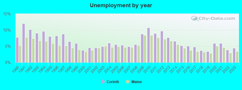
| Here: | 4.4% |
| Maine: | 3.4% |
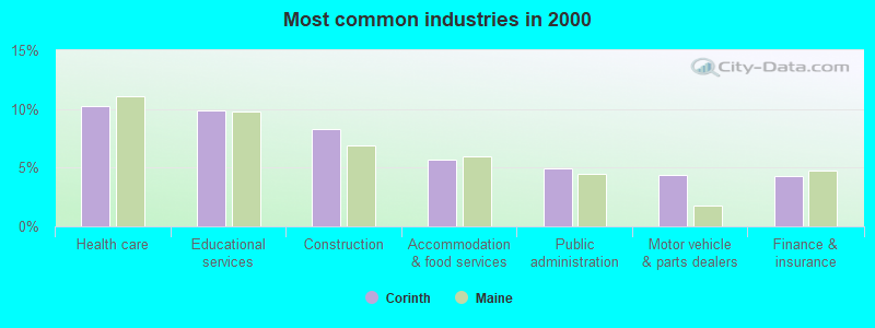
- Health care (10.3%)
- Educational services (9.9%)
- Construction (8.3%)
- Accommodation & food services (5.7%)
- Public administration (4.9%)
- Motor vehicle & parts dealers (4.4%)
- Finance & insurance (4.3%)
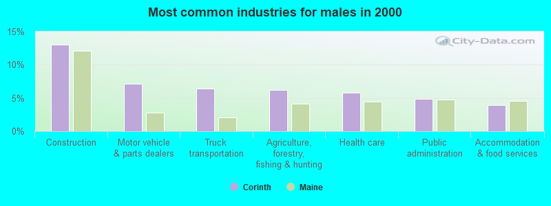
- Construction (13.1%)
- Motor vehicle & parts dealers (7.1%)
- Truck transportation (6.4%)
- Agriculture, forestry, fishing & hunting (6.2%)
- Health care (5.8%)
- Public administration (4.9%)
- Accommodation & food services (3.9%)

- Educational services (17.0%)
- Health care (15.5%)
- Accommodation & food services (7.8%)
- Finance & insurance (7.1%)
- Public administration (4.9%)
- Religious, grantmaking, civic, professional, similar organizations (4.4%)
- Personal & laundry services (4.4%)

- Other sales and related occupations, including supervisors (6.2%)
- Vehicle and mobile equipment mechanics, installers, and repairers (5.1%)
- Driver/sales workers and truck drivers (4.6%)
- Other production occupations, including supervisors (4.1%)
- Building and grounds cleaning and maintenance occupations (3.8%)
- Material recording, scheduling, dispatching, and distributing workers (3.4%)
- Cashiers (3.3%)

- Vehicle and mobile equipment mechanics, installers, and repairers (9.4%)
- Driver/sales workers and truck drivers (8.5%)
- Other sales and related occupations, including supervisors (7.0%)
- Other production occupations, including supervisors (5.9%)
- Electrical equipment mechanics and other installation, maintenance, and repair workers, including supervisors (4.6%)
- Metal workers and plastic workers (3.9%)
- Material recording, scheduling, dispatching, and distributing workers (3.9%)

- Building and grounds cleaning and maintenance occupations (7.8%)
- Secretaries and administrative assistants (6.5%)
- Cashiers (5.8%)
- Other sales and related occupations, including supervisors (5.3%)
- Other office and administrative support workers, including supervisors (4.8%)
- Personal appearance workers (3.7%)
- Cooks and food preparation workers (3.5%)
Average climate in Corinth, Maine
Based on data reported by over 4,000 weather stations


(lower is better)
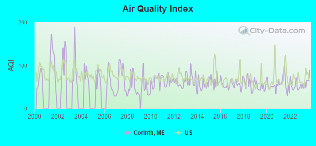
Air Quality Index (AQI) level in 2023 was 61.1. This is about average.
| City: | 61.1 |
| U.S.: | 72.6 |
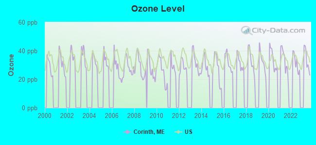
Ozone [ppb] level in 2023 was 33.6. This is about average. Closest monitor was 16.2 miles away from the city center.
| City: | 33.6 |
| U.S.: | 33.3 |
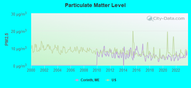
Particulate Matter (PM2.5) [µg/m3] level in 2023 was 5.62. This is significantly better than average. Closest monitor was 16.1 miles away from the city center.
| City: | 5.62 |
| U.S.: | 8.11 |
Earthquake activity:
Corinth-area historical earthquake activity is significantly above Maine state average. It is 81% smaller than the overall U.S. average.On 4/20/2002 at 10:50:47, a magnitude 5.3 (5.3 ML, Depth: 3.0 mi, Class: Moderate, Intensity: VI - VII) earthquake occurred 233.1 miles away from Corinth center
On 10/16/2012 at 23:12:25, a magnitude 4.7 (4.7 ML, Depth: 10.0 mi, Class: Light, Intensity: IV - V) earthquake occurred 126.3 miles away from the city center
On 4/20/2002 at 10:50:47, a magnitude 5.2 (5.2 MB, 4.2 MS, 5.2 MW, 5.0 MW) earthquake occurred 234.4 miles away from Corinth center
On 10/7/1983 at 10:18:46, a magnitude 5.3 (5.1 MB, 5.3 LG, 5.1 ML) earthquake occurred 273.2 miles away from Corinth center
On 1/19/1982 at 00:14:42, a magnitude 4.7 (4.5 MB, 4.7 MD, 4.5 LG) earthquake occurred 164.8 miles away from Corinth center
On 2/26/1999 at 03:38:43, a magnitude 3.8 (3.8 LG, Depth: 2.0 mi, Class: Light, Intensity: II - III) earthquake occurred 43.4 miles away from Corinth center
Magnitude types: regional Lg-wave magnitude (LG), body-wave magnitude (MB), duration magnitude (MD), local magnitude (ML), surface-wave magnitude (MS), moment magnitude (MW)
Natural disasters:
The number of natural disasters in Penobscot County (19) is greater than the US average (15).Major Disasters (Presidential) Declared: 11
Emergencies Declared: 7
Causes of natural disasters: Floods: 9, Storms: 8, Snows: 5, Heavy Rains: 2, Blizzard: 1, Hurricane: 1, Ice Storm: 1, Snowfall: 1, Wind: 1, Winter Storm: 1, Other: 2 (Note: some incidents may be assigned to more than one category).
Hospitals and medical centers near Corinth:
- DEXTER HEALTH CARE (Nursing Home, about 15 miles away; DEXTER, ME)
- BANGOR AREA VISITING NURSES (Home Health Center, about 15 miles away; BANGOR, ME)
- HOSPICE OF EASTERN MAINE (Hospital, about 15 miles away; BANGOR, ME)
- KINDRED NURSING AND REHABILITATION-WESTGATE (Nursing Home, about 16 miles away; BANGOR, ME)
- BANGOR NURSING AND REHABILITATION (Nursing Home, about 16 miles away; BANGOR, ME)
- ROSS MANOR (Nursing Home, about 16 miles away; BANGOR, ME)
Colleges/universities with over 2000 students nearest to Corinth:
- Husson University (about 15 miles; Bangor, ME; Full-time enrollment: 2,421)
- University of Maine (about 18 miles; Orono, ME; FT enrollment: 8,931)
- University of Maine at Augusta (about 60 miles; Augusta, ME; FT enrollment: 3,204)
- University of Maine at Farmington (about 61 miles; Farmington, ME; FT enrollment: 2,036)
- Saint Joseph's College of Maine (about 109 miles; Standish, ME; FT enrollment: 2,010)
- Southern Maine Community College (about 111 miles; South Portland, ME; FT enrollment: 4,666)
- University of Southern Maine (about 112 miles; Portland, ME; FT enrollment: 6,647)
Public elementary/middle school in Corinth:
- MORISON MEMORIAL SCHOOL (Location: 386 MAIN ST 7, Grades: 3-5)
Points of interest:
Notable locations in Corinth: Corinth Volunteer Rescue Service (A), Corinth Volunteer Fire Department (B). Display/hide their locations on the map
Cemeteries: Corinthian Cemetery (1), Boutell Cemetery (2), Evergreen Cemetery (3). Display/hide their locations on the map
Streams, rivers, and creeks: Allen Stream (A), Pierre Paul Brook (B), Crooked Brook (C). Display/hide their locations on the map
Birthplace of: Arthur R. Gould - Politician.
Drinking water stations with addresses in Corinth and their reported violations in the past:
A E ROBINSON MOBILE MART (Population served: 75, Groundwater):Past health violations:POLYOTS MOBILE HOME PARK (Population served: 73, Groundwater):
- MCL, Monthly (TCR) - In MAR-2008, Contaminant: Coliform. Follow-up actions: St Public Notif requested (MAR-06-2008), St Formal NOV issued (MAR-06-2008), St Public Notif received (MAR-13-2008), St Compliance achieved (SEP-07-2011)
- MCL, Monthly (TCR) - Between JAN-2008 and MAR-2008, Contaminant: Coliform. Follow-up actions: St Public Notif requested (JAN-22-2008), St Formal NOV issued (JAN-22-2008), St Public Notif received (FEB-12-2008), St Compliance achieved (SEP-07-2011)
- MCL, Monthly (TCR) - In DEC-2007, Contaminant: Coliform. Follow-up actions: St Public Notif requested (DEC-06-2007), St Formal NOV issued (DEC-06-2007), St Public Notif received (DEC-19-2007), St Compliance achieved (SEP-07-2011)
- MCL, Monthly (TCR) - Between OCT-2007 and DEC-2007, Contaminant: Coliform. Follow-up actions: St Public Notif requested (NOV-19-2007), St Formal NOV issued (NOV-19-2007), St Public Notif received (NOV-29-2007), St Compliance achieved (SEP-07-2011)
- MCL, Single Sample - In MAY-2005, Contaminant: Benzene. Follow-up actions: St Public Notif requested (MAY-13-2005), St Violation/Reminder Notice (MAY-13-2005), St Public Notif received (2 times from JUN-02-2005 to JUN-02-2005), St Compliance achieved (SEP-06-2011)
Past health violations:WHITNEYS FAMILY SUPERMARKET (Population served: 32, Groundwater):Past monitoring violations:
- MCL, Monthly (TCR) - In APR-2006, Contaminant: Coliform. Follow-up actions: St Violation/Reminder Notice (APR-10-2006), St Public Notif requested (APR-10-2006), St Public Notif received (MAY-09-2006), St Compliance achieved (JUL-26-2012)
- MCL, Monthly (TCR) - In DEC-2005, Contaminant: Coliform. Follow-up actions: St Violation/Reminder Notice (DEC-09-2005), St Public Notif requested (DEC-09-2005), St Public Notif received (2 times from JAN-12-2006 to JAN-12-2006), St Compliance achieved (JUL-26-2012)
- MCL, Monthly (TCR) - In NOV-2005, Contaminant: Coliform. Follow-up actions: St Public Notif requested (NOV-18-2005), St Violation/Reminder Notice (NOV-18-2005), St Public Notif received (2 times from DEC-08-2005 to DEC-08-2005), St Compliance achieved (JUL-26-2012)
- One routine major monitoring violation
Past monitoring violations:
- One routine major monitoring violation
| This town: | 2.6 people |
| Maine: | 2.3 people |
| This town: | 70.9% |
| Whole state: | 62.9% |
| This town: | 10.9% |
| Whole state: | 9.4% |
Likely homosexual households (counted as self-reported same-sex unmarried-partner households)
- Lesbian couples: 0.3% of all households
- Gay men: 0.7% of all households
| This town: | 8.0% |
| Whole state: | 10.9% |
| This town: | 2.4% |
| Whole state: | 4.1% |
4 people in homes for the mentally retarded in 2000
For population 15 years and over in Corinth:
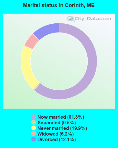
- Never married: 19.9%
- Now married: 61.3%
- Separated: 0.5%
- Widowed: 6.2%
- Divorced: 12.1%
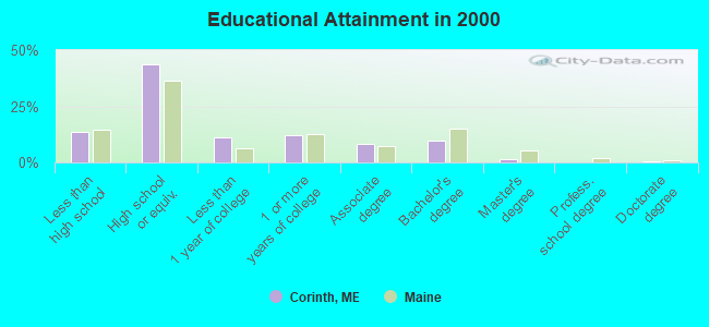
For population 25 years and over in Corinth:
- High school or higher: 86.2%
- Bachelor's degree or higher: 11.4%
- Graduate or professional degree: 1.9%
- Unemployed: 5.7%
- Mean travel time to work (commute): 29.5 minutes
| Here: | 9.0 |
| Maine average: | 11.2 |


Graphs represent county-level data. Detailed 2008 Election Results
Religion statistics for Corinth, ME (based on Penobscot County data)


| Religion | Adherents | Congregations |
|---|---|---|
| Catholic | 16,581 | 15 |
| Mainline Protestant | 9,715 | 59 |
| Evangelical Protestant | 7,523 | 80 |
| Other | 2,936 | 22 |
| Orthodox | 300 | 1 |
| None | 116,868 | - |
Food Environment Statistics:
| Here: | 2.29 / 10,000 pop. |
| State: | 2.80 / 10,000 pop. |
| This county: | 0.13 / 10,000 pop. |
| State: | 0.14 / 10,000 pop. |
| Here: | 2.56 / 10,000 pop. |
| State: | 2.20 / 10,000 pop. |
| Here: | 5.72 / 10,000 pop. |
| State: | 5.75 / 10,000 pop. |
| Penobscot County: | 7.41 / 10,000 pop. |
| State: | 11.02 / 10,000 pop. |
| Penobscot County: | 9.0% |
| State: | 8.2% |
| This county: | 28.0% |
| Maine: | 25.0% |
Businesses in Corinth, ME
- Dunkin Donuts: 1
Strongest AM radio stations in Corinth:
- WZON (620 AM; 5 kW; BANGOR, ME; Owner: THE ZONE CORPORATION)
- WABI (910 AM; 5 kW; BANGOR, ME; Owner: CLEAR CHANNEL BROADCASTING LICENSES, INC.)
- WSKW (1160 AM; 10 kW; SKOWHEGAN, ME; Owner: MOUNTAIN WIRELESS, INCORPORATED)
- WNZS (1340 AM; 1 kW; VEAZIE, ME; Owner: WATERFRONT COMMUNICATIONS INC.)
- WDEA (1370 AM; 5 kW; ELLSWORTH, ME; Owner: CUMULUS LICENSING CORP.)
- WTME (780 AM; 10 kW; RUMFORD, ME; Owner: MOUNTAIN VALLEY BROADCASTING, INC.)
- WRKO (680 AM; 50 kW; BOSTON, MA; Owner: ENTERCOM BOSTON LICENSE, LLC)
- WEEI (850 AM; 50 kW; BOSTON, MA; Owner: ENTERCOM BOSTON LICENSE, LLC)
- WBZ (1030 AM; 50 kW; BOSTON, MA; Owner: INFINITY BROADCASTING OPERATIONS, INC.)
- WCRN (830 AM; 50 kW; WORCESTER, MA; Owner: CARTER BROADCASTING CORPORATION)
- WNNZ (640 AM; 50 kW; WESTFIELD, MA; Owner: CLEAR CHANNEL BROADCASTING LICENSES, INC.)
- WCHP (760 AM; 35 kW; CHAMPLAIN, NY; Owner: CHAMPLAIN RADIO, INC.)
- WFAU (1280 AM; 5 kW; GARDINER, ME; Owner: CAPSTAR TX LIMITED PARTNERSHIP)
Strongest FM radio stations in Corinth:
- WQCB (106.5 FM; BREWER, ME; Owner: CUMULUS LICENSING CORP.)
- WWBX (97.1 FM; BANGOR, ME; Owner: CLEAR CHANNEL BROADCASTING LICENSES, INC.)
- WVOM (103.9 FM; HOWLAND, ME; Owner: CLEAR CHANNEL BROADCASTING LICENSES, INC.)
- WGUY (102.1 FM; DEXTER, ME; Owner: CONCORD MEDIA GROUP, INC.)
- WBZN (107.3 FM; OLD TOWN, ME; Owner: CUMULUS LICENSING CORP.)
- WHCF (88.5 FM; BANGOR, ME; Owner: BANGOR BAPTIST CHURCH)
- WBFB (104.7 FM; BELFAST, ME; Owner: CLEAR CHANNEL BROADCASTING LICENSES, INC.)
- WKIT-FM (100.3 FM; BREWER, ME; Owner: THE ZONE CORPORATION)
- WWMJ (95.7 FM; ELLSWORTH, ME; Owner: CUMULUS LICENSING CORP.)
- WMEH (90.9 FM; BANGOR, ME; Owner: MAINE PUBLIC BROADCASTING CORPORATION)
- WEZQ (92.9 FM; BANGOR, ME; Owner: CUMULUS LICENSING CORP.)
- WTOS-FM (105.1 FM; SKOWHEGAN, ME; Owner: CAPSTAR TX LIMITED PARTNERSHIP)
- WFZX (101.7 FM; SEARSPORT, ME; Owner: CLEAR CHANNEL BROADCASTING LICENSES, INC.)
- WJCX (99.5 FM; PITTSFIELD, ME; Owner: CSN INTERNATIONAL)
- WDME-FM (103.1 FM; DOVER-FOXCROFT, ME; Owner: THE ZONE CORPORATION)
- WMEB-FM (91.9 FM; ORONO, ME; Owner: UNIVERSITY OF MAINE SYSTEM)
TV broadcast stations around Corinth:
- WABI-TV (Channel 5; BANGOR, ME; Owner: COMMUNITY BROADCASTING SERVICE)
- W36CK (Channel 36; BANGOR, ME; Owner: TRINITY BROADCASTING NETWORK)
- WMEB-TV (Channel 12; ORONO, ME; Owner: MAINE PUBLIC BROADCASTING CORPORATION)
- WBGR-LP (Channel 33; BANGOR/DEDHAM, ME; Owner: MAINE FAMILY BROADCASTING, INC.)
- WCKD-LP (Channel 30; BANGOR/DEDHAM, ME; Owner: J. MCLEOD, ME FAMILY B/CING., INC.)
- National Bridge Inventory (NBI) Statistics
- 12Number of bridges
- 92ft / 27.9mTotal length
- 14,320Total average daily traffic
- 709Total average daily truck traffic
- 21,077Total future (year 2036) average daily traffic
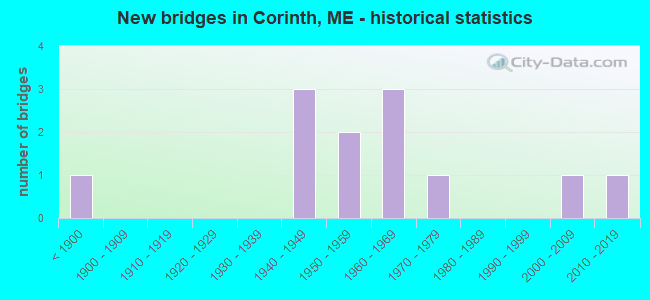
- New bridges - historical statistics
- 1Before 1900
- 31940-1949
- 21950-1959
- 31960-1969
- 11970-1979
- 12000-2009
- 12010-2019
FCC Registered Antenna Towers:
5- Mark L Gartley, 534 Main St (Lat: 44.991278 Lon: -69.014306), Type: 59.4, Overall height: 57.9 m, Registrant: Holland & Knight LLP, Pconnolly@hklaw.Com, , Washi-ngton, Phone: (202) 862-5989
- Mark L Gartley, 534 Main St (Lat: 44.991278 Lon: -69.014306), Type: 59.4, Overall height: 57.9 m, Registrant: Holland & Knight LLP, Pconnolly@hklaw.Com, , Washi-ngton, Phone: (202) 862-5989
- Cayla Gamble, 534 Main St (Lat: 44.991333 Lon: -69.013917), Type: 59.1, Structure height: 23019 m, Overall height: 57.9 m, Registrant: Holland & Knight LLP, Peter.Connolly@hklaw.Com, , Washi-ngton, Phone: (202) 862-5989
- Cayla Gamble, 534 Main St (Lat: 44.991333 Lon: -69.013917), Type: 59.1, Structure height: 23019 m, Overall height: 57.9 m, Registrant: Holland & Knight LLP, Peter.Connolly@hklaw.Com, , Washi-ngton, Phone: (202) 862-5989
- Cayla Gamble, 534 Main St (Lat: 44.991333 Lon: -69.013917), Type: 59.1, Structure height: 23019 m, Overall height: 57.9 m, Registrant: Wilkinson Barker Knauer, LLP, Gwerner@wbklaw.Com, , Washi-ngton, Phone: (202) 383-3420
FCC Registered Broadcast Land Mobile Towers:
3- Fire Station Main St (Lat: 45.001722 Lon: -69.023917), Call Sign: WQJ553, Licensee ID: L00040006,
Assigned Frequencies: 154.310 MHz, Grant Date: 05/24/2000, Expiration Date: 08/03/2005, Cancellation Date: 01/07/2006, Registrant: Corinth, Town Of, 31 Exeter Rd, Corinth, ME 04427, Phone: (207) 285-3271
- Fire Station Main St (Lat: 45.001722 Lon: -69.023917), Call Sign: KNCN217, Licensee ID: L00040006,
Assigned Frequencies: 154.085 MHz, Grant Date: 10/22/1996, Expiration Date: 01/07/2002, Cancellation Date: 05/05/2002, Registrant: Corinth, Town Of, Box 10 Exeter Rd, East Corinth, ME 04427, Phone: (207) 285-3271
- Lat: 44.992639 Lon: -69.009167, Call Sign: WQJQ312,
Assigned Frequencies: 452.025 MHz, 452.225 MHz, 453.000 MHz, Grant Date: 10/20/2018, Expiration Date: 11/24/2028, Certifier: Mark Parent, Registrant: Federal Licensnig Inc, 1588 Fairfield Road, Gettysburg, PA 17325, Phone: (717) 334-9262, Fax: (717) 334-6440
FCC Registered Microwave Towers:
1- East Corinth, 530 Main St (Lat: 44.991361 Lon: -69.013917), Type: Ltower, Structure height: 58.2 m, Overall height: 58.8 m, Call Sign: WQTN866,
Assigned Frequencies: 10935.0 MHz, 10775.0 MHz, 10815.0 MHz, 10935.0 MHz, 10775.0 MHz, 10815.0 MHz, 10935.0 MHz, 10775.0 MHz, 10815.0 MHz, 10935.0 MHz... (+35 more), Grant Date: 03/14/2014, Expiration Date: 03/14/2024, Cancellation Date: 07/24/2020, Certifier: Jessica B Lyons, Registrant: At&t Services, Inc., 208 S Akard St, Rm 2100, Dallas, TX 75202, Phone: (855) 699-7073, Fax: (214) 746-6410, Email:
FCC Registered Amateur Radio Licenses:
7- Call Sign: KB1PT, Licensee ID: L00804739, Grant Date: 11/06/2017, Expiration Date: 01/06/2028, Certifier: Merland E Clark Jr, Registrant: Merland E Clark Jr, 105 Exeter Rd, Corinth, ME 04427
- Call Sign: KE7CM, Licensee ID: L00926023, Grant Date: 08/12/2014, Expiration Date: 10/26/2024, Certifier: Jeanne L Slasor, Registrant: Jeanne L Slasor, Corinth, ME 04427
- Call Sign: N1JRM, Licensee ID: L00347962, Grant Date: 01/26/2012, Expiration Date: 07/16/2021, Cancellation Date: 07/18/2023, Certifier: Robert G Kelliher, Registrant: Robert G Kelliher, 85 Covered Bridge Rd, Corinth, ME 04427
- Call Sign: N1TXW, Licensee ID: L00244834, Grant Date: 10/14/2014, Expiration Date: 12/29/2024, Certifier: Dale M Moore, Registrant: Dale M Moore, Corinth, ME 04427-0166
- Call Sign: WA1RKA, Licensee ID: L00398696, Grant Date: 10/27/1998, Expiration Date: 09/06/2006, Cancellation Date: 11/04/2008, Certifier: John M Manter, Registrant: John M Manter, Corinth, ME 04427
- Call Sign: KB1PXS, Licensee ID: L01368376, Grant Date: 12/21/2017, Expiration Date: 02/11/2028, Certifier: Randolph R Tomasik, Registrant: Randolph R Tomasik, 37 Ridge Rd, Corinth, ME 04427
- Call Sign: KC1BTI, Licensee ID: L01861746, Grant Date: 04/29/2014, Expiration Date: 04/29/2024, Certifier: Jo-Anne Conway, Registrant: Jo-Anne Conway, 520 Grant Rd, Corinth, ME 04427
FAA Registered Aircraft:
3- Aircraft: CESSNA 172L (Category: Land, Seats: 4, Weight: Up to 12,499 Pounds, Speed: 105 mph), Engine: LYCOMING 0-320 SERIES (180 HP) (Reciprocating)
N-Number: 19792, N19792, N-19792, Serial Number: 17260756, Year manufactured: 1972, Airworthiness Date: 06/29/1972, Certificate Issue Date: 07/19/2002
Registrant (Co-Owned): Dalton M Trustee Dunfee, 588 Main St, Corinth, ME 04427, Other Owners: Lois E Trustee Dunfee - Aircraft: BEECH 23 (Category: Land, Seats: 4, Weight: Up to 12,499 Pounds, Speed: 113 mph), Engine: LYCOMING 0-320 SERIES (180 HP) (Reciprocating)
N-Number: 2318Z, N2318Z, N-2318Z, Serial Number: M-45, Year manufactured: 1962, Airworthiness Date: 10/15/1962, Certificate Issue Date: 10/24/2014
Registrant (Individual): Ronda L Crosson, 265 Black Rd, Corinth, ME 04427 - Aircraft: CESSNA 182P (Category: Land, Seats: 4, Weight: Up to 12,499 Pounds, Speed: 120 mph), Engine: CONT MOTOR O-470 SERIES (230 HP) (Reciprocating)
N-Number: 52595, N52595, N-52595, Serial Number: 18262696, Year manufactured: 1973, Airworthiness Date: 12/28/1973, Certificate Issue Date: 12/20/2018
Registrant (Individual): Michael G Mchugh, 356 White Schoolhouse Rd, Corinth, ME 04427
2003 - 2018 National Fire Incident Reporting System (NFIRS) incidents
- Fire incident types reported to NFIRS in Corinth, ME
- 19261.3%Structure Fires
- 8125.9%Outside Fires
- 3310.5%Mobile Property/Vehicle Fires
- 72.2%Other
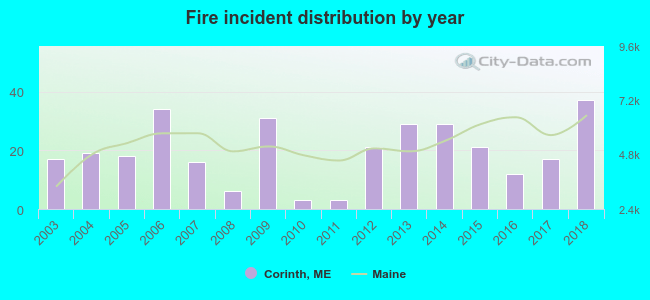 According to the data from the years 2003 - 2018 the average number of fires per year is 20. The highest number of reported fire incidents - 37 took place in 2018, and the least - 3 in 2010. The data has a growing trend.
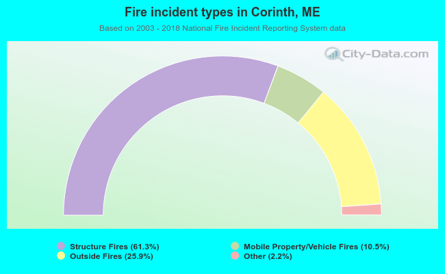 When looking into fire subcategories, the most incidents belonged to: Structure Fires (61.3%), and Outside Fires (25.9%).
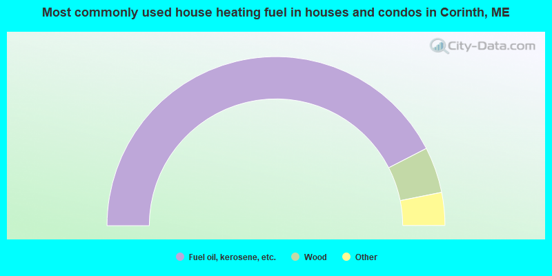
- 84.9%Fuel oil, kerosene, etc.
- 8.8%Wood
- 2.6%Electricity
- 2.5%Bottled, tank, or LP gas
- 1.2%Coal or coke
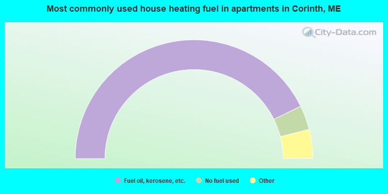
- 85.5%Fuel oil, kerosene, etc.
- 6.6%No fuel used
- 2.6%Bottled, tank, or LP gas
- 2.6%Electricity
- 2.6%Wood
Corinth compared to Maine state average:
- Unemployed percentage below state average.
- Black race population percentage significantly below state average.
- Hispanic race population percentage below state average.
- Foreign-born population percentage significantly below state average.
- Renting percentage below state average.
- Length of stay since moving in significantly above state average.
- Number of rooms per house significantly below state average.
- House age significantly below state average.
- Percentage of population with a bachelor's degree or higher significantly below state average.