Coopers, Georgia
Submit your own pictures of this place and show them to the world
- OSM Map
- General Map
- Google Map
- MSN Map

| Males: 3,872 | |
| Females: 3,123 |
| Median resident age: | 33.4 years |
| Georgia median age: | 33.4 years |
Zip code: 31061
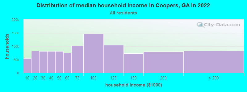
| Coopers: | $55,713 |
| GA: | $72,837 |
Estimated per capita income in 2022: $28,764 (it was $14,564 in 2000)
Coopers CCD income, earnings, and wages data
Estimated median house or condo value in 2022: $155,437 (it was $58,600 in 2000)
| Coopers: | $155,437 |
| GA: | $297,400 |
Mean prices in 2022: all housing units: $226,449; detached houses: $261,412; townhouses or other attached units: $212,045; in 2-unit structures: $140,742; mobile homes: $76,383
Detailed information about poverty and poor residents in Coopers, GA


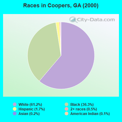
- 4,11661.2%White alone
- 2,44236.3%Black alone
- 1121.7%Hispanic
- 310.5%Two or more races
- 160.2%Asian alone
- 80.1%American Indian alone
- 20.03%Native Hawaiian and Other
Pacific Islander alone
Races in Coopers detailed stats: ancestries, foreign born residents, place of birth
 Recent articles from our blog. Our writers, many of them Ph.D. graduates or candidates, create easy-to-read articles on a wide variety of topics.

Current Local Time: EST time zone
Elevation: 389 feet
Land area: 76.2 square miles.
Population density: 92 people per square mile (very low).

| Coopers CCD: | 0.6% ($347) |
| Georgia: | 0.9% ($919) |
Nearest city with pop. 50,000+: Macon, GA  (24.0 miles , pop. 97,255).
Nearest city with pop. 200,000+: Atlanta, GA (83.9 miles , pop. 416,474).
Nearest city with pop. 1,000,000+: Chicago, IL (657.3 miles , pop. 2,896,016).
Nearest cities:
), ), ), )Latitude: 33.00 N, Longitude: 83.27 W
Area code commonly used in this area: 478

| Here: | 3.5% |
| Georgia: | 2.9% |
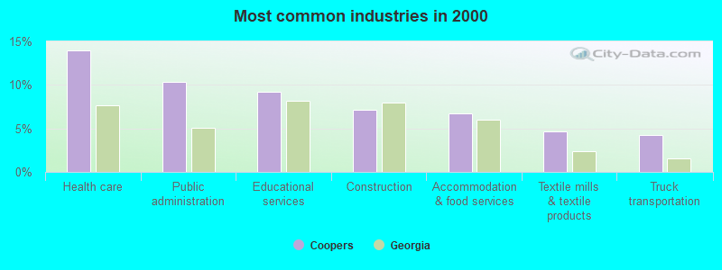
- Health care (14.0%)
- Public administration (10.4%)
- Educational services (9.2%)
- Construction (7.2%)
- Accommodation & food services (6.7%)
- Textile mills & textile products (4.6%)
- Truck transportation (4.2%)
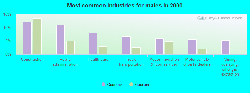
- Construction (12.2%)
- Public administration (11.0%)
- Health care (8.0%)
- Truck transportation (6.8%)
- Accommodation & food services (5.9%)
- Motor vehicle & parts dealers (5.6%)
- Mining, quarrying, oil & gas extraction (5.2%)
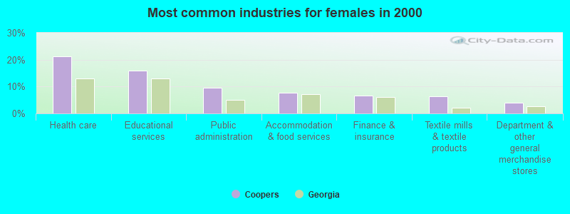
- Health care (21.1%)
- Educational services (15.9%)
- Public administration (9.6%)
- Accommodation & food services (7.8%)
- Finance & insurance (6.6%)
- Textile mills & textile products (6.4%)
- Department & other general merchandise stores (4.0%)
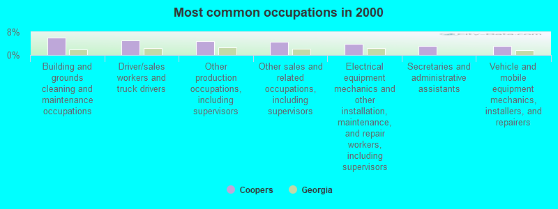
- Building and grounds cleaning and maintenance occupations (6.1%)
- Driver/sales workers and truck drivers (5.1%)
- Other production occupations, including supervisors (4.8%)
- Other sales and related occupations, including supervisors (4.5%)
- Electrical equipment mechanics and other installation, maintenance, and repair workers, including supervisors (3.9%)
- Secretaries and administrative assistants (3.3%)
- Vehicle and mobile equipment mechanics, installers, and repairers (3.2%)
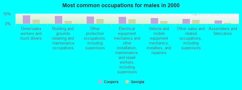
- Driver/sales workers and truck drivers (8.8%)
- Building and grounds cleaning and maintenance occupations (8.2%)
- Other production occupations, including supervisors (7.5%)
- Electrical equipment mechanics and other installation, maintenance, and repair workers, including supervisors (7.2%)
- Vehicle and mobile equipment mechanics, installers, and repairers (6.0%)
- Other sales and related occupations, including supervisors (5.2%)
- Assemblers and fabricators (3.7%)
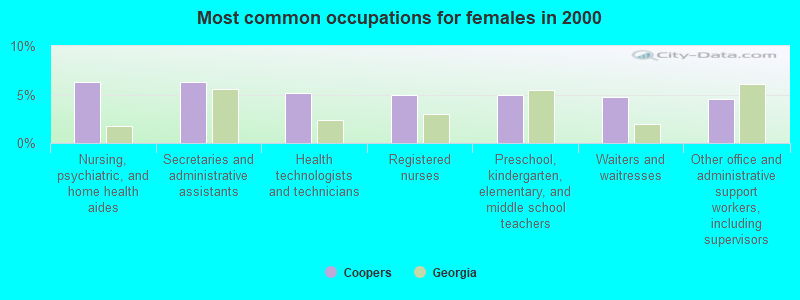
- Nursing, psychiatric, and home health aides (6.3%)
- Secretaries and administrative assistants (6.2%)
- Health technologists and technicians (5.1%)
- Registered nurses (5.0%)
- Preschool, kindergarten, elementary, and middle school teachers (4.9%)
- Waiters and waitresses (4.7%)
- Other office and administrative support workers, including supervisors (4.5%)
Average climate in Coopers, Georgia
Based on data reported by over 4,000 weather stations


(lower is better)
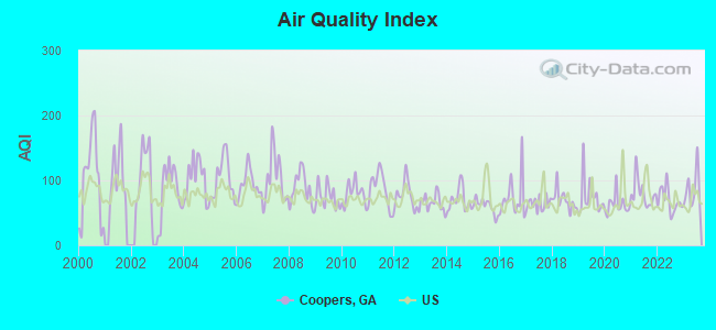
Air Quality Index (AQI) level in 2023 was 86.2. This is about average.
| City: | 86.2 |
| U.S.: | 72.6 |
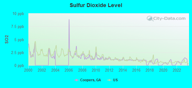
Sulfur Dioxide (SO2) [ppb] level in 2023 was 1.31. This is about average. Closest monitor was 10.5 miles away from the city center.
| City: | 1.31 |
| U.S.: | 1.51 |
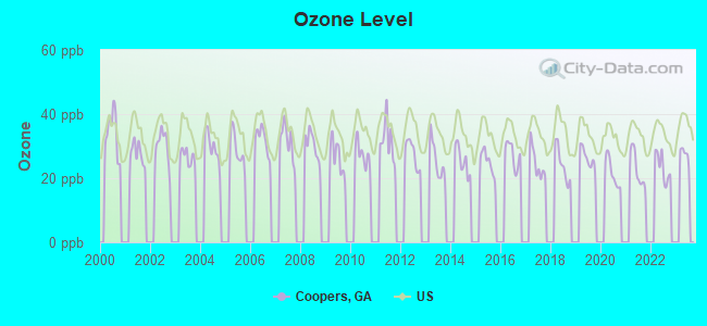
Ozone [ppb] level in 2022 was 23.4. This is significantly better than average. Closest monitor was 21.1 miles away from the city center.
| City: | 23.4 |
| U.S.: | 33.3 |
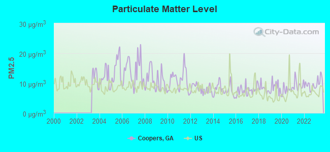
Particulate Matter (PM2.5) [µg/m3] level in 2023 was 10.7. This is worse than average. Closest monitor was 9.2 miles away from the city center.
| City: | 10.7 |
| U.S.: | 8.1 |
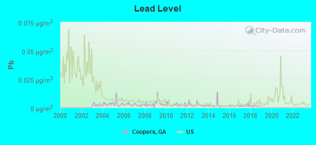
Lead (Pb) [µg/m3] level in 2018 was 0.00153. This is significantly better than average. Closest monitor was 10.5 miles away from the city center.
| City: | 0.00153 |
| U.S.: | 0.00931 |
Tornado activity:
Coopers-area historical tornado activity is slightly below Georgia state average. It is 3% greater than the overall U.S. average.
On 11/22/1992, a category F4 (max. wind speeds 207-260 mph) tornado 16.2 miles away from the Coopers place center killed 5 people and injured 86 people and caused between $5,000,000 and $50,000,000 in damages.
On 4/30/1953, a category F4 tornado 34.0 miles away from the place center killed 18 people and injured 300 people and caused between $5,000,000 and $50,000,000 in damages.
Earthquake activity:
Coopers-area historical earthquake activity is significantly above Georgia state average. It is 5% greater than the overall U.S. average.On 8/2/1974 at 08:52:09, a magnitude 4.9 (4.3 MB, 4.9 LG, Class: Light, Intensity: IV - V) earthquake occurred 75.0 miles away from the city center
On 4/29/2003 at 08:59:39, a magnitude 4.9 (4.4 MB, 4.6 MW, 4.9 LG) earthquake occurred 170.5 miles away from Coopers center
On 11/22/1974 at 05:25:55, a magnitude 4.7 (4.7 MB) earthquake occurred 181.3 miles away from Coopers center
On 4/29/2003 at 08:59:39, a magnitude 4.6 (4.6 MW, Depth: 12.3 mi) earthquake occurred 170.6 miles away from Coopers center
On 8/9/2020 at 12:07:37, a magnitude 5.1 (5.1 MW, Depth: 4.7 mi, Class: Moderate, Intensity: VI - VII) earthquake occurred 270.1 miles away from Coopers center
On 11/30/1973 at 07:48:41, a magnitude 4.7 (4.7 MB, 4.6 ML) earthquake occurred 197.4 miles away from the city center
Magnitude types: regional Lg-wave magnitude (LG), body-wave magnitude (MB), local magnitude (ML), moment magnitude (MW)
Natural disasters:
The number of natural disasters in Baldwin County (7) is smaller than the US average (15).Major Disasters (Presidential) Declared: 2
Emergencies Declared: 4
Causes of natural disasters: Winter Storms: 3, Drought: 1, Flood: 1, Hurricane: 1, Snowfall: 1, Storm: 1, Tornado: 1, Other: 1 (Note: some incidents may be assigned to more than one category).
Hospitals and medical centers near Coopers:
- GREEN ACRES INC (Nursing Home, about 4 miles away; MILLEDGEVILLE, GA)
- CHAPLINWOOD NH (Nursing Home, about 4 miles away; MILLEDGEVILLE, GA)
- CHAPLINWOOD NURSING HOME (Nursing Home, about 4 miles away; MILLEDGEVILLE, GA)
- DAVITA INC MILLEDGEVILLE (Dialysis Facility, about 6 miles away; MILLEDGEVILLE, GA)
- MEDICAL KIDNEY SERVICES OF CENTRAL GEORGIA, LTD (Dialysis Facility, about 6 miles away; MILLEDGEVILLE, GA)
- ABC HOME HEALTH OF MILLEDGEVILLE (Home Health Center, about 6 miles away; MILLEDGEVILLE, GA)
- ORMC/ HOSPICE OF THE OCONEE (Hospital, about 7 miles away; MILLEDGEVILLE, GA)
Colleges/universities with over 2000 students nearest to Coopers:
- Georgia Military College-Distance Learning Campuses (about 6 miles; Milledgeville, GA; Full-time enrollment: 6,438)
- Georgia College and State University (about 6 miles; Milledgeville, GA; FT enrollment: 6,271)
- Mercer University (about 26 miles; Macon, GA; FT enrollment: 6,297)
- Middle Georgia State College (about 31 miles; Macon, GA; FT enrollment: 7,091)
- Central Georgia Technical College (about 40 miles; Warner Robins, GA; FT enrollment: 6,829)
- Fort Valley State University (about 49 miles; Fort Valley, GA; FT enrollment: 3,200)
- Gordon State College (about 52 miles; Barnesville, GA; FT enrollment: 3,336)
Points of interest:
Notable locations in Coopers: Stevens Pottery (A), Baldwin County Fire and Rescue Department Station 4 (B). Display/hide their locations on the map
Churches in Coopers include: Coopers Hill Church (A), County Line Church (B), Emmanuel Church (C), Hopewell Church (D), Oak Grove Methodist Church (E), Mitchell Zion Church (F), Mount Hope Church (G), Mount Pleasant Church (H), Oak Grove Church (I). Display/hide their locations on the map
Cemeteries: David Hill Cemetery (1), Leonard Smith Cemetery (2), Newton Cemetery (3), Bland Cemetery (4), Oak Grove Cemetery (5), Camp Creek Cemetery (6), Georgia Veterans Memorial Cemetery (7). Display/hide their locations on the map
Reservoirs: Fountain Lake (A), Hollinshead Pond (B), Georgia Lake Number Nine (C), McClure Lake (D), Beckham Lake (E), Georgia State Hospital Lake West (F), Fountain Lake (G), Willoughby Lake (H). Display/hide their locations on the map
Creeks: Moore Creek (A), Goss Creek (B), Camp Creek (C), Reedy Creek (D), Buck Creek (E). Display/hide their locations on the map
| This place: | 2.6 people |
| Georgia: | 2.6 people |
| This place: | 71.4% |
| Whole state: | 68.5% |
| This place: | 5.9% |
| Whole state: | 5.9% |
Likely homosexual households (counted as self-reported same-sex unmarried-partner households)
- Lesbian couples: 0.3% of all households
- Gay men: 0.1% of all households
| This place: | 10.1% |
| Whole state: | 13.0% |
| This place: | 4.9% |
| Whole state: | 6.1% |
175 people in mental (psychiatric) hospitals and psychiatric units in other hospitals in 2010
926 people in state prisons in 2000
For population 15 years and over in Coopers:
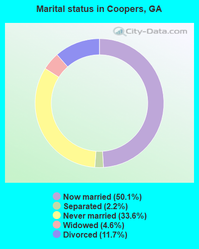
- Never married: 33.6%
- Now married: 50.1%
- Separated: 2.2%
- Widowed: 4.6%
- Divorced: 11.7%
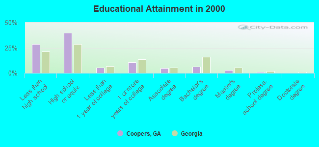
For population 25 years and over in Coopers:
- High school or higher: 71.4%
- Bachelor's degree or higher: 10.6%
- Graduate or professional degree: 4.3%
- Unemployed: 4.4%
- Mean travel time to work (commute): 21.7 minutes
| Here: | 11.2 |
| Georgia average: | 13.3 |
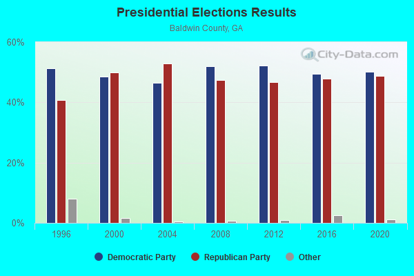
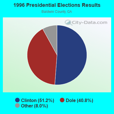
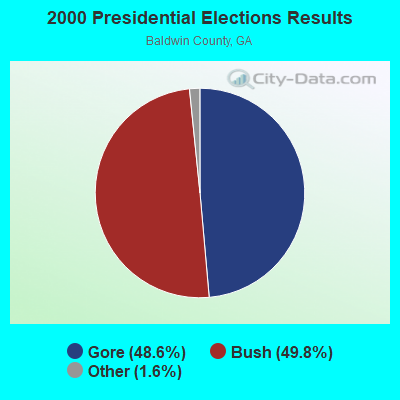
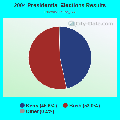
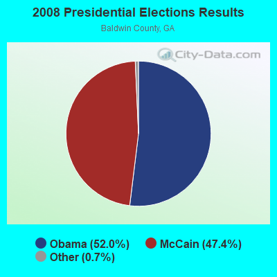
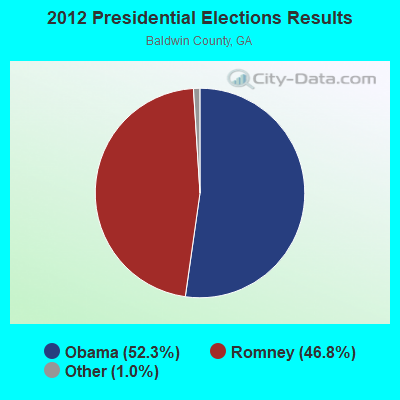
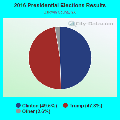
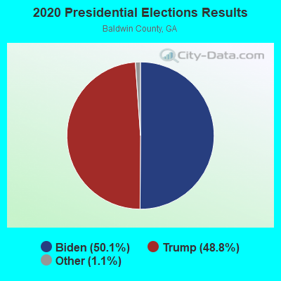
Graphs represent county-level data. Detailed 2008 Election Results
Religion statistics for Coopers, GA (based on Baldwin County data)
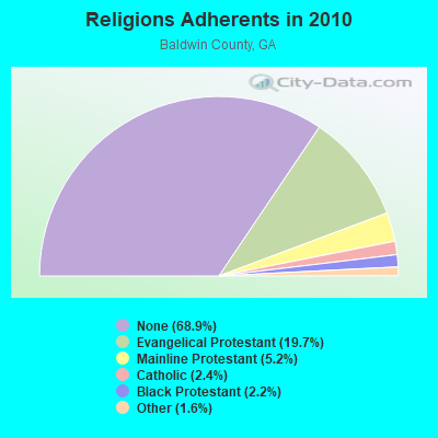
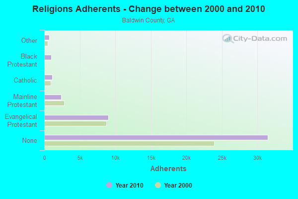
| Religion | Adherents | Congregations |
|---|---|---|
| Evangelical Protestant | 9,014 | 39 |
| Mainline Protestant | 2,370 | 8 |
| Catholic | 1,100 | 1 |
| Black Protestant | 1,007 | 6 |
| Other | 733 | 3 |
| None | 31,496 | - |
Food Environment Statistics:
| This county: | 2.37 / 10,000 pop. |
| Georgia: | 1.91 / 10,000 pop. |
| Baldwin County: | 0.86 / 10,000 pop. |
| Georgia: | 0.86 / 10,000 pop. |
| Here: | 6.69 / 10,000 pop. |
| Georgia: | 5.12 / 10,000 pop. |
| This county: | 5.82 / 10,000 pop. |
| Georgia: | 7.41 / 10,000 pop. |
| Here: | 10.9% |
| Georgia: | 10.4% |
| This county: | 31.0% |
| Georgia: | 27.8% |
| Baldwin County: | 15.5% |
| State: | 14.6% |
Strongest AM radio stations in Coopers:
- WMAC (940 AM; 50 kW; MACON, GA; Owner: CUMULUS LICENSING CORP.)
- WXJO (1120 AM; daytime; 10 kW; GORDON, GA; Owner: ROBERTS COMMUNICATIONS, INC.)
- WMVG (1450 AM; 1 kW; MILLEDGEVILLE, GA; Owner: WMVG, INC.)
- WKGQ (1060 AM; daytime; 1 kW; MILLEDGEVILLE, GA; Owner: KEYSTONE ENTERPRISES, INC.)
- WGST (640 AM; 50 kW; ATLANTA, GA; Owner: CITICASTERS LICENSES, L.P.)
- WSB (750 AM; 50 kW; ATLANTA, GA; Owner: CXR HOLDINGS, INC.)
- WNNG (1350 AM; 15 kW; WARNER ROBINS, GA; Owner: CHASE BROADCASTING, INC.)
- WCNN (680 AM; 50 kW; NORTH ATLANTA, GA; Owner: DICKEY BROADCASTING COMPANY)
- WGUN (1010 AM; 50 kW; ATLANTA, GA; Owner: WGUN, INC.)
- WLCG (1280 AM; 5 kW; MACON, GA)
- WQXI (790 AM; 28 kW; ATLANTA, GA; Owner: JEFFERSON-PILOT COMMUNICATIONS COMPANY OF GEORGIA)
- WAOK (1380 AM; 50 kW; ATLANTA, GA; Owner: INFINITY BROADCASTING OPERATIONS, INC.)
- WMLB (1160 AM; 50 kW; EAST POINT, GA; Owner: ATLANTA AREA BROADCASTING, INC.)
Strongest FM radio stations in Coopers:
- WKZR (102.3 FM; MILLEDGEVILLE, GA; Owner: WMVG, INC.)
- WFXM (107.1 FM; GORDON, GA; Owner: ROBERTS COMMUNICATIONS, INC.)
- WGUR (88.9 FM; MILLEDGEVILLE, GA; Owner: GEORGIA COLLEGE & STATE UNIVERSITY)
- WVKX (103.7 FM; IRWINTON, GA; Owner: WILKINSON BROADCASTING, INC.)
- WLRR (100.7 FM; MILLEDGEVILLE, GA; Owner: PRESTON W. SMALL)
- W201BN (88.1 FM; MILLEDGEVILLE, GA; Owner: CALVARY CHAPEL OF TWIN FALLS, INC.)
- WPEZ (93.7 FM; JEFFERSONVILLE, GA; Owner: CUMULUS LICENSING CORP.)
- WAYS (105.5 FM; MACON, GA; Owner: CUMULUS LICENSING CORP.)
- WDEN-FM (99.1 FM; MACON, GA; Owner: CUMULUS LICENSING CORP.)
- WDCO-FM (89.7 FM; COCHRAN, GA; Owner: GEORGIA PUBLIC TELECOMMUNICATIONS COMMISSION)
- WMGZ (97.7 FM; EATONTON, GA; Owner: MIDDLE GEORGIA COMMUNICATIONS, INC.)
- WBKG (88.9 FM; MACON, GA; Owner: AMERICAN FAMILY ASSOCIATION)
- WPWB (90.5 FM; BYRON, GA; Owner: AUGUSTA RADIO FELLOWSHIP INST., INC.)
- WYNF (96.5 FM; GRAY, GA; Owner: CLEVELAND RADIO LICENSES, LLC)
- WJFL (101.9 FM; TENNILLE, GA; Owner: FALL LINE MEDIA, INC.)
TV broadcast stations around Coopers:
- WPGA-TV (Channel 58; PERRY, GA; Owner: RADIO PERRY, INC.)
- WMGT-TV (Channel 41; MACON, GA; Owner: MORRIS NETWORK, INC.)
- WMAZ-TV (Channel 13; MACON, GA; Owner: GANNETT GEORGIA, L.P.)
- WGXA (Channel 24; MACON, GA; Owner: PIEDMONT TELEVISION OF MACON LICENSE LLC)
- WDMA-LP (Channel 32; MACON, GA; Owner: WORD OF GOD FELLOWSHIP, INC.)
- WGNM (Channel 64; MACON, GA; Owner: GOOD NEWS TELEVISION)
- WDCO-TV (Channel 29; COCHRAN, GA; Owner: GEORGIA PUBLIC TELECOMMUNICATIONS COMMISSION)
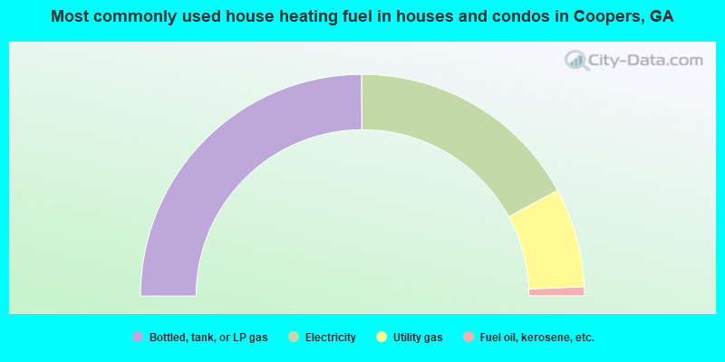
- 49.9%Bottled, tank, or LP gas
- 34.3%Electricity
- 14.5%Utility gas
- 1.3%Fuel oil, kerosene, etc.
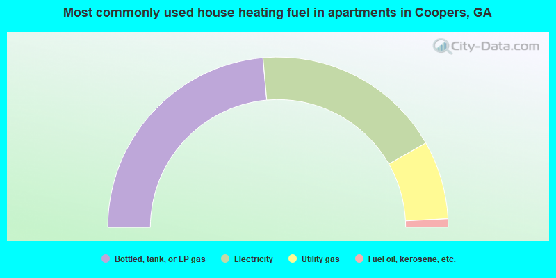
- 47.2%Bottled, tank, or LP gas
- 36.3%Electricity
- 14.9%Utility gas
- 1.6%Fuel oil, kerosene, etc.
Coopers compared to Georgia state average:
- Median house value below state average.
- Unemployed percentage significantly below state average.
- Hispanic race population percentage significantly below state average.
- Median age below state average.
- Foreign-born population percentage significantly below state average.
- Renting percentage below state average.
- Length of stay since moving in significantly above state average.
- Number of rooms per house significantly below state average.
- House age significantly below state average.
- Institutionalized population percentage significantly above state average.
- Percentage of population with a bachelor's degree or higher below state average.
Coopers on our top lists:
- #11 on the list of "Top 101 cities with largest percentage of females in occupations: secondary school teachers (population 5,000+)"
- #14 on the list of "Top 101 cities with largest percentage of males in industries: motor vehicle and parts dealers (population 5,000+)"
- #22 on the list of "Top 101 cities with largest percentage of males in industries: truck transportation (population 5,000+)"
- #26 on the list of "Top 101 cities with largest percentage of females in industries: textile mills and textile products (population 5,000+)"
- #32 on the list of "Top 101 cities with largest percentage of males in occupations: therapists (population 5,000+)"
- #35 on the list of "Top 101 cities with largest percentage of males in occupations: secretaries and administrative assistants (population 5,000+)"
- #36 on the list of "Top 101 cities with largest percentage of males in occupations: assemblers and fabricators (population 5,000+)"
- #37 on the list of "Top 101 cities with largest percentage of males in occupations: counselors, social workers, and other community and social service specialists (population 5,000+)"
- #41 on the list of "Top 101 cities with largest percentage of females in occupations: nursing, psychiatric, and home health aides (population 5,000+)"
- #44 on the list of "Top 101 cities with largest percentage of males in industries: wood products (population 5,000+)"
- #51 on the list of "Top 101 cities with largest percentage of females in industries: machinery (population 5,000+)"
- #59 on the list of "Top 101 cities with largest percentage of males in industries: textile mills and textile products (population 5,000+)"
- #63 on the list of "Top 101 cities with largest percentage of males in industries: fuel dealers (population 5,000+)"
- #66 on the list of "Top 101 cities with largest percentage of males in industries: farm supplies merchant wholesalers (population 5,000+)"
- #66 on the list of "Top 101 cities with largest percentage of males in industries: health care (population 5,000+)"
- #75 on the list of "Top 101 cities with the largest percentage of mobile homes (2,000+ housing units)"
- #81 on the list of "Top 101 cities with largest percentage of females in industries: truck transportation (population 5,000+)"
- #92 on the list of "Top 101 cities with largest percentage of females in industries: wood products (population 5,000+)"
- #75 on the list of "Top 101 counties with the lowest ground withdrawal of fresh water for public supply"