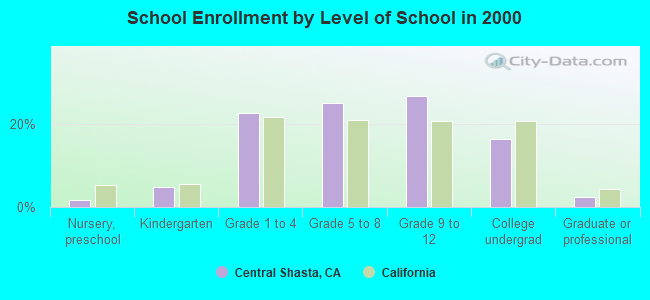
Central Shasta, California
Submit your own pictures of this place and show them to the world
- OSM Map
- General Map
- Google Map
- MSN Map

| Males: 5,872 | |
| Females: 5,595 |
| Median resident age: | 44.6 years |
| California median age: | 33.3 years |
Zip code: 96069
| Central Shasta: | $73,412 |
| CA: | $91,551 |
Estimated per capita income in 2022: $38,243 (it was $19,223 in 2000)
Central Shasta CCD income, earnings, and wages data
Estimated median house or condo value in 2022: $415,174 (it was $132,000 in 2000)
| Central Shasta: | $415,174 |
| CA: | $715,900 |
Mean prices in 2022: all housing units: $370,501; detached houses: $409,007; townhouses or other attached units: $359,872; in 2-unit structures: $411,184; in 3-to-4-unit structures: $437,892; in 5-or-more-unit structures: $487,419; mobile homes: $134,922; occupied boats, rvs, vans, etc.: $31,319
Central Shasta, CA residents, houses, and apartments details
Detailed information about poverty and poor residents in Central Shasta, CA
Compare current foreclosures near Central Shasta, CA:
| Photo | Address | Area | Beds / Baths | Price | Details |
|---|---|---|---|---|---|

|
#1
Bridger Way
Oak Run, CA 96069
|
1,494 sq. feet
|
2 baths 2 beds |
show details | |

|
#2
Hidden Meadows Rd
Shingletown, CA 96088
|
- sq. feet
|
2 baths 2 beds |
show details | |

|
#3
Hidden Meadows Rd
Shingletown, CA 96088
|
- sq. feet
|
2 baths 3 beds |
show details | |

|
#4
Clarabelle Ln
Shingletown, CA 96088
|
- sq. feet
|
1 baths 2 beds |
show details | |

|
#5
Corinthians Way
Shingletown, CA 96088
|
- sq. feet
|
2 baths 3 beds |
show details | |

|
#6
Lake Mccumber Rd
Shingletown, CA 96088
|
- sq. feet
|
1 baths 1 beds |
show details | |

|
#7
Camino Vis
Shingletown, CA 96088
|
- sq. feet
|
2 baths 3 beds |
show details | |

|
#8
Rosa Ln
Montgomery Creek, CA 96065
|
- sq. feet
|
- baths - beds |
show details | |

|
#9
Camino Real
Shingletown, CA 96088
|
- sq. feet
|
- baths - beds |
show details | |

|
#10
Broken Ridge Rd
Round Mountain, CA 96084
|
- sq. feet
|
- baths - beds |
show details |
| Photo | Address | Area | Beds / Baths | Price | Details |
|---|---|---|---|---|---|

|
#11
Thumper Dr
Shingletown, CA 96088
|
- sq. feet
|
- baths - beds |
show details | |

|
#12
Star Trek Dr
Shingletown, CA 96088
|
- sq. feet
|
- baths - beds |
show details | |

|
Check over 1 million property listings on Foreclosure.com!
|
browse all offers | |||

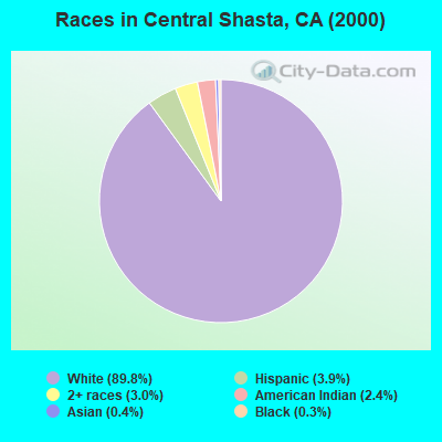
- 9,40689.8%White alone
- 4113.9%Hispanic
- 3143.0%Two or more races
- 2552.4%American Indian alone
- 380.4%Asian alone
- 300.3%Black alone
- 100.10%Other race alone
- 90.09%Native Hawaiian and Other
Pacific Islander alone
 Recent articles from our blog. Our writers, many of them Ph.D. graduates or candidates, create easy-to-read articles on a wide variety of topics.

Current Local Time: PST time zone
Land area: 1497.2 square miles.
Population density: 7.7 people per square mile (very low).

| Central Shasta CCD: | 0.8% ($1,098) |
| California: | 0.8% ($1,564) |
Nearest city with pop. 50,000+: Redding, CA  (25.8 miles , pop. 80,865).
Nearest city with pop. 200,000+: Sacramento, CA (149.9 miles , pop. 407,018).
Nearest city with pop. 1,000,000+: Los Angeles, CA (496.5 miles , pop. 3,694,820).
Nearest cities:
), Latitude: 40.70 N, Longitude: 121.90 W
Area code commonly used in this area: 530
| Here: | 5.6% |
| California: | 5.1% |
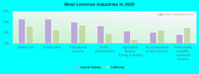
- Health care (11.4%)
- Construction (11.2%)
- Educational services (9.8%)
- Public administration (8.2%)
- Agriculture, forestry, fishing & hunting (5.7%)
- Accommodation & food services (5.2%)
- Professional, scientific, technical services (4.1%)
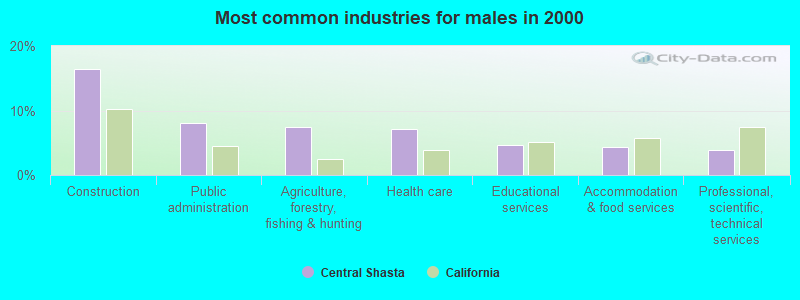
- Construction (16.5%)
- Public administration (8.1%)
- Agriculture, forestry, fishing & hunting (7.4%)
- Health care (7.1%)
- Educational services (4.7%)
- Accommodation & food services (4.3%)
- Professional, scientific, technical services (3.9%)
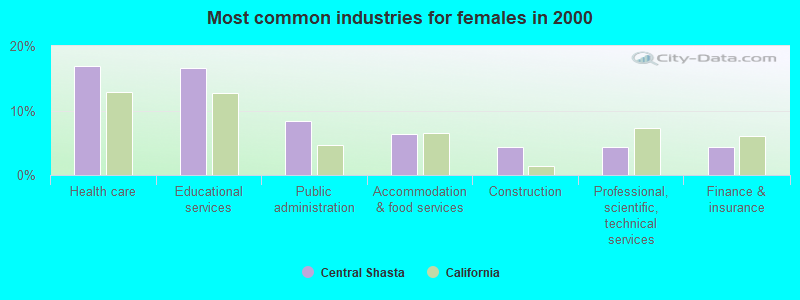
- Health care (17.0%)
- Educational services (16.5%)
- Public administration (8.3%)
- Accommodation & food services (6.3%)
- Construction (4.4%)
- Professional, scientific, technical services (4.4%)
- Finance & insurance (4.3%)
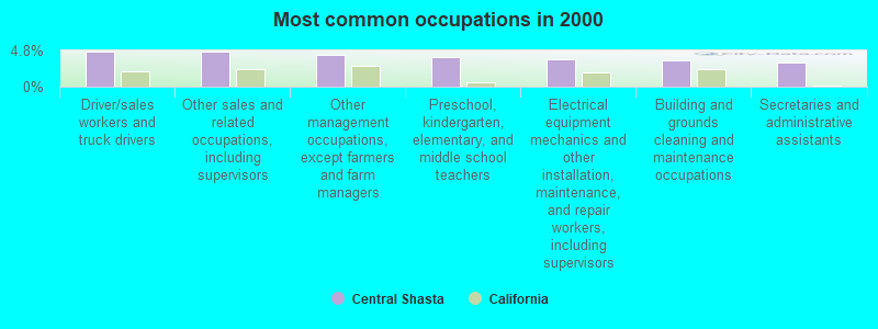
- Driver/sales workers and truck drivers (4.7%)
- Other sales and related occupations, including supervisors (4.6%)
- Other management occupations, except farmers and farm managers (4.2%)
- Preschool, kindergarten, elementary, and middle school teachers (3.9%)
- Electrical equipment mechanics and other installation, maintenance, and repair workers, including supervisors (3.6%)
- Building and grounds cleaning and maintenance occupations (3.5%)
- Secretaries and administrative assistants (3.1%)
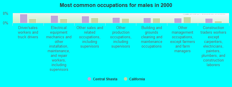
- Driver/sales workers and truck drivers (7.6%)
- Electrical equipment mechanics and other installation, maintenance, and repair workers, including supervisors (6.2%)
- Other sales and related occupations, including supervisors (5.7%)
- Other production occupations, including supervisors (4.6%)
- Building and grounds cleaning and maintenance occupations (4.3%)
- Other management occupations, except farmers and farm managers (4.2%)
- Construction traders workers except carpenters, electricians, painters, plumbers, and construction laborers (4.0%)
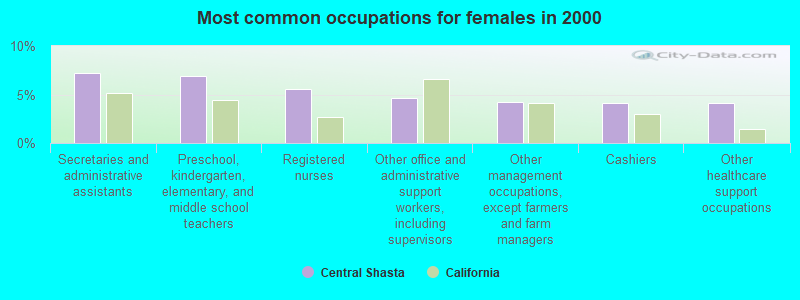
- Secretaries and administrative assistants (7.2%)
- Preschool, kindergarten, elementary, and middle school teachers (6.9%)
- Registered nurses (5.6%)
- Other office and administrative support workers, including supervisors (4.7%)
- Other management occupations, except farmers and farm managers (4.2%)
- Cashiers (4.1%)
- Other healthcare support occupations (4.1%)
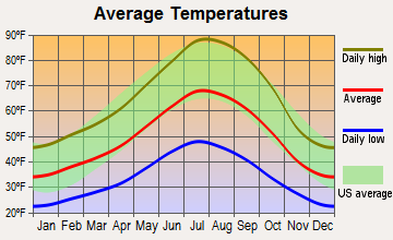
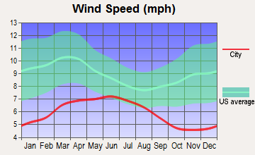
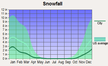
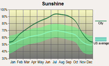
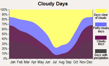
Average climate in Central Shasta, California
Based on data reported by over 4,000 weather stations
(lower is better)
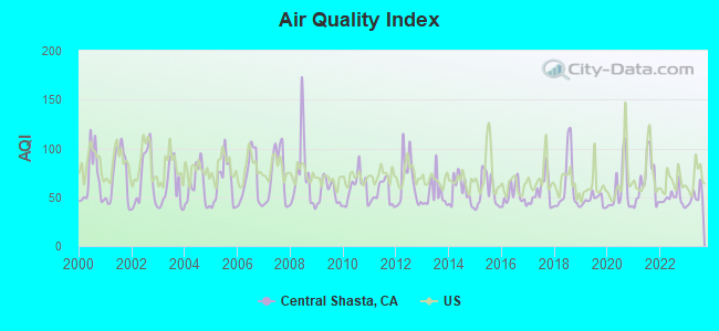
Air Quality Index (AQI) level in 2023 was 50.2. This is significantly better than average.
| City: | 50.2 |
| U.S.: | 72.6 |
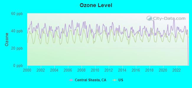
Ozone [ppb] level in 2023 was 41.2. This is worse than average. Closest monitor was 17.8 miles away from the city center.
| City: | 41.2 |
| U.S.: | 33.3 |
Earthquake activity:
Central Shasta-area historical earthquake activity is significantly above California state average. It is 5130% greater than the overall U.S. average.On 4/18/1906 at 13:12:21, a magnitude 7.9 (7.9 UK, Class: Major, Intensity: VIII - XII) earthquake occurred 195.5 miles away from Central Shasta center, causing $524,000,000 total damage
On 1/31/1922 at 13:17:28, a magnitude 7.6 (7.6 UK) earthquake occurred 191.3 miles away from the city center
On 4/25/1992 at 18:06:04, a magnitude 7.2 (6.3 MB, 7.1 MS, 7.2 MW, 7.1 MW, Depth: 9.4 mi) earthquake occurred 116.3 miles away from the city center, causing $75,000,000 total damage
On 11/8/1980 at 10:27:34, a magnitude 7.2 (6.2 MB, 7.2 MS, 7.2 MW, 7.0 ML) earthquake occurred 128.5 miles away from the city center
On 10/3/1915 at 06:52:48, a magnitude 7.6 (7.6 UK) earthquake occurred 231.7 miles away from the city center
On 1/22/1923 at 09:04:18, a magnitude 7.2 (7.2 UK) earthquake occurred 180.2 miles away from Central Shasta center
Magnitude types: body-wave magnitude (MB), local magnitude (ML), surface-wave magnitude (MS), moment magnitude (MW)
Natural disasters:
The number of natural disasters in Shasta County (29) is a lot greater than the US average (15).Major Disasters (Presidential) Declared: 13
Emergencies Declared: 4
Causes of natural disasters: Floods: 14, Fires: 12, Storms: 8, Winter Storms: 6, Landslides: 5, Mudslides: 4, Drought: 1, Heavy Rain: 1, Hurricane: 1, Tornado: 1, Wind: 1, Other: 1 (Note: some incidents may be assigned to more than one category).
Colleges/universities with over 2000 students nearest to Central Shasta:
- Shasta College (about 23 miles; Redding, CA; Full-time enrollment: 5,645)
- California State University-Chico (about 68 miles; Chico, CA; FT enrollment: 14,838)
- Butte College (about 74 miles; Oroville, CA; FT enrollment: 8,649)
- Oregon Institute of Technology (about 109 miles; Klamath Falls, OR; FT enrollment: 2,900)
- Yuba College (about 111 miles; Marysville, CA; FT enrollment: 4,737)
- Southern Oregon University (about 111 miles; Ashland, OR; FT enrollment: 4,650)
- Humboldt State University (about 115 miles; Arcata, CA; FT enrollment: 7,353)
Points of interest:
Notable locations in Central Shasta: Squaw Creek Fire Control Station (A), Buckhorn Forest Fire Station (B), Bunchgrass Campground (C), Lost Creek Organization Campground (D), Sulphur Works (E), Camp McCumber (F), The Plantation (G), Tollgate (H), Coleman Fish Hatchery (I), Cutter Place Campground (J), Pine Point Campground (K), Asbury Pipe (L), Coleman Powerhouse (M), Cow Creek Powerhouse (N), Witherow Ranch (O), Wheeler Ranch (P), South Cow Creek Campground (Q), Sheep Camp (R), Scharsch Ranch (S), Ritts Mill (T). Display/hide their locations on the map
Cemeteries: Parkville Cemetery (1), Halcumb Cemetery (2), Whitmore Cemetery (3), Fern Cemetery (4), Independent Order of Odd Fellows Cemetery (5), Ogburn Inwood Cemetery (6), Cove Cemetery (7). Display/hide their locations on the map
Lakes and reservoirs: Swan Lake (A), Carobe Lake (B), Hemlock Lake (C), Big Lake (D), Little Bear Lake (E), Upper Twin Lake (F), Emerald Lake (G), Tule Lake (H). Display/hide their locations on the map
Creeks: Bridges Creek (A), Brush Creek (B), Bull Creek (C), Bunchgrass Creek (D), Butcherknife Creek (E), Centipede Creek (F), Claiborne Creek (G), Cow Creek (H), Crooks Creek (I). Display/hide their locations on the map
Park in Central Shasta: Lassen Volcanic National Park (1). Display/hide its location on the map
| This place: | 2.4 people |
| California: | 2.9 people |
| This place: | 70.0% |
| Whole state: | 68.7% |
| This place: | 7.0% |
| Whole state: | 7.2% |
Likely homosexual households (counted as self-reported same-sex unmarried-partner households)
- Lesbian couples: 0.4% of all households
- Gay men: 0.4% of all households
| This place: | 14.3% |
| Whole state: | 14.2% |
| This place: | 6.1% |
| Whole state: | 6.3% |
People in group quarters in Central Shasta in 2010:
- 115 people in state prisons
- 22 people in group homes for juveniles (non-correctional)
- 5 people in workers' group living quarters and job corps centers
7 people in other group homes in 2000
For population 15 years and over in Central Shasta:
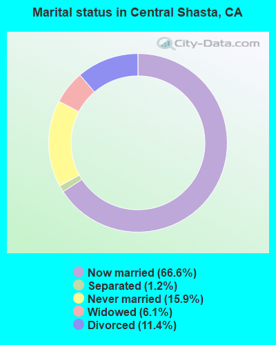
- Never married: 15.9%
- Now married: 66.6%
- Separated: 1.2%
- Widowed: 6.1%
- Divorced: 11.4%
For population 25 years and over in Central Shasta:
- High school or higher: 84.2%
- Bachelor's degree or higher: 15.8%
- Graduate or professional degree: 5.5%
- Unemployed: 10.9%
- Mean travel time to work (commute): 29.6 minutes
| Here: | 8.9 |
| California average: | 16.1 |
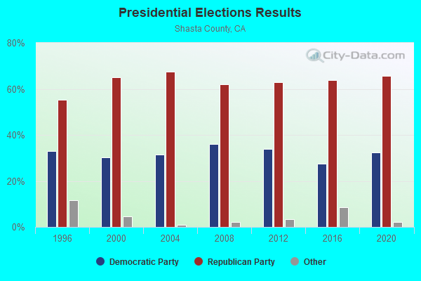
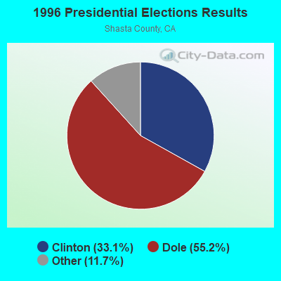
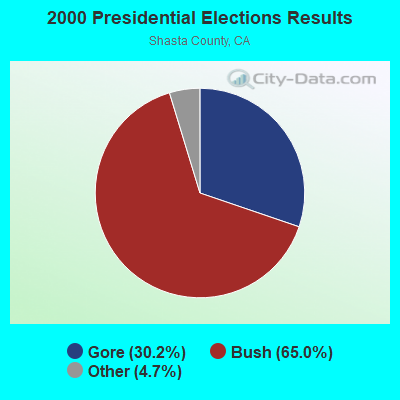
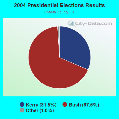
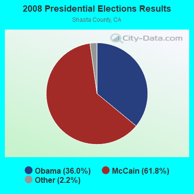
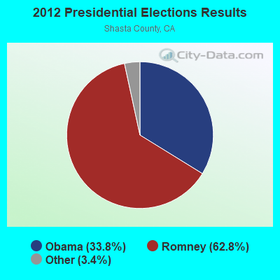
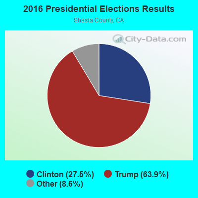

Graphs represent county-level data. Detailed 2008 Election Results
Religion statistics for Central Shasta, CA (based on Shasta County data)
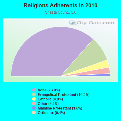
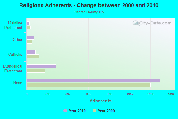
| Religion | Adherents | Congregations |
|---|---|---|
| Evangelical Protestant | 28,805 | 109 |
| Catholic | 8,629 | 8 |
| Other | 7,277 | 29 |
| Mainline Protestant | 2,830 | 12 |
| Orthodox | 191 | 5 |
| Black Protestant | 120 | 1 |
| None | 129,371 | - |
Food Environment Statistics:
| Shasta County: | 2.35 / 10,000 pop. |
| California: | 2.14 / 10,000 pop. |
| This county: | 0.06 / 10,000 pop. |
| California: | 0.04 / 10,000 pop. |
| This county: | 0.39 / 10,000 pop. |
| California: | 0.62 / 10,000 pop. |
| Here: | 3.85 / 10,000 pop. |
| California: | 1.49 / 10,000 pop. |
| This county: | 6.42 / 10,000 pop. |
| California: | 7.42 / 10,000 pop. |
| Shasta County: | 8.0% |
| California: | 7.3% |
| Shasta County: | 25.3% |
| California: | 21.3% |
| Shasta County: | 15.4% |
| California: | 17.9% |
Strongest AM radio stations in Central Shasta:
- KNRO (1670 AM; 10 kW; REDDING, CA; Owner: REGENT LICENSEE OF REDDING, INC.)
- KVIP (540 AM; 2 kW; REDDING, CA; Owner: PACIFIC CASCADE COMMUNICATIONS CORP.)
- KKOH (780 AM; 50 kW; RENO, NV; Owner: CITADEL BROADCASTING COMPANY)
- KCBS (740 AM; 50 kW; SAN FRANCISCO, CA; Owner: INFINITY BROADCASTING OPERATIONS, INC.)
- KFBK (1530 AM; 50 kW; SACRAMENTO, CA; Owner: AMFM RADIO LICENSES, L.L.C.)
- KFIA (710 AM; 25 kW; CARMICHAEL, CA; Owner: VISTA BROADCASTING INC.)
- KHTK (1140 AM; 50 kW; SACRAMENTO, CA; Owner: INFINITY RADIO SUBSIDIARY OPERATIONS INC.)
- KSTE (650 AM; 25 kW; RANCHO CORDOVA, CA; Owner: AMFM RADIO LICENSES, L.L.C.)
- KNBR (680 AM; 50 kW; SAN FRANCISCO, CA; Owner: KNBR LICO, INC.)
- KCBC (770 AM; 50 kW; RIVERBANK, CA; Owner: KIERTRON, INC.)
- KTRB (860 AM; 50 kW; MODESTO, CA; Owner: PAPPAS RADIO OF CALIFORNIA, A CALIFORNIA LIMITED PARTNERSHIP)
- KTMT (580 AM; 10 kW; ASHLAND, OR; Owner: MAPLETON COMMUNICATIONS, LLC)
- KGO (810 AM; 50 kW; SAN FRANCISCO, CA; Owner: KGO-AM RADIO, INC.)
Strongest FM radio stations in Central Shasta:
- KKRO (91.5 FM; REDDING, CA; Owner: EDUCATIONAL MEDIA FOUNDATION)
- KRDG (105.3 FM; SHINGLETOWN, CA; Owner: REGENT LICENSEE OF REDDING, INC.)
- KNCA (89.7 FM; BURNEY, CA; Owner: OREGON STATE BOARD OF HIGHER ED.)
- KRRX (106.1 FM; BURNEY, CA; Owner: REGENT LICENSEE OF REDDING, INC.)
- K220EB (91.9 FM; BURNEY, CA; Owner: THE UNIVERSITY FOUNDATION)
- KIBC (90.5 FM; BURNEY, CA; Owner: BURNEY EDUC. BROADCASTING FOUNDATION)
- KKXS (96.1 FM; SHINGLETOWN, CA; Owner: RESULTS RADIO LICENSEE, LLC)
- KHRD (103.1 FM; WEAVERVILLE, CA; Owner: RESULTS RADIO LICENSEE, LLC)
- KNCQ (97.3 FM; REDDING, CA; Owner: RESULTS RADIO OF REDDING, LLC)
- KLVB-FM (102.7 FM; RED BLUFF, CA; Owner: EDUCATIONAL MEDIA FOUNDATION)
- K225AJ (92.9 FM; BURNEY/REDDING, CA; Owner: CALVARY CHAPEL OF TWIN FALLS, INC.)
- KVIP-FM (98.1 FM; REDDING, CA; Owner: PACIFIC CASCADE COMMUNICATIONS CORP.)
- KNNN (99.3 FM; SHASTA LAKE CITY, CA; Owner: REGENT LICENSEE OF REDDING, INC.)
- KEWB (94.7 FM; ANDERSON, CA; Owner: RESULTS RADIO OF REDDING, LLC)
- KSHA (104.3 FM; REDDING, CA; Owner: REGENT LICENSEE OF REDDING, INC)
- KNSQ (88.1 FM; MOUNT SHASTA, CA; Owner: STATE OF ORE./STATE BD. OF HGR. ED.)
- K205EJ (88.9 FM; CHESTER, CA; Owner: CALVARY CHAPEL OF TWIN FALLS, INC.)
- K268AJ (101.5 FM; REDDING, CA; Owner: FAMILY STATIONS, INC.)
- K227AE (93.3 FM; REDDING, CA; Owner: RESULTS RADIO OF REDDING, LLC)
- KESR (107.1 FM; SHASTA LAKE CITY, CA; Owner: RESULTS RADIO OF REDDING, LLC)
TV broadcast stations around Central Shasta:
- KNVN (Channel 24; CHICO, CA; Owner: CHICO LICENSE, L.L.C.)
- K02GV (Channel 2; MONTGOMERY CREEK,ETC, CA; Owner: ROUND MOUNTAIN COMMUNITY TV CORP.)
FCC Registered Broadcast Land Mobile Towers:
1- IRON CANYON DAM, Iron Canyon Dam (Lat: 41.041556 Lon: -121.986944), Type: Tower, Structure height: 15.2 m, Call Sign: WQLL736,
Assigned Frequencies: 173.362 MHz, Grant Date: 03/03/2010, Expiration Date: 03/03/2020, Cancellation Date: 02/04/2011, Certifier: Jennifer Dekeyser, Registrant: Pacific Gas And Electric Company, 487 West Shaw Ave Bldg "b", Fresno, CA 93704, Phone: (599) 263-5631, Fax: (599) 263-5899, Email:
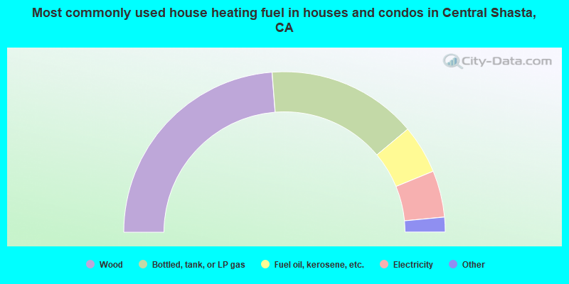
- 47.6%Wood
- 30.3%Bottled, tank, or LP gas
- 9.8%Fuel oil, kerosene, etc.
- 9.4%Electricity
- 1.6%Other fuel
- 1.4%Utility gas
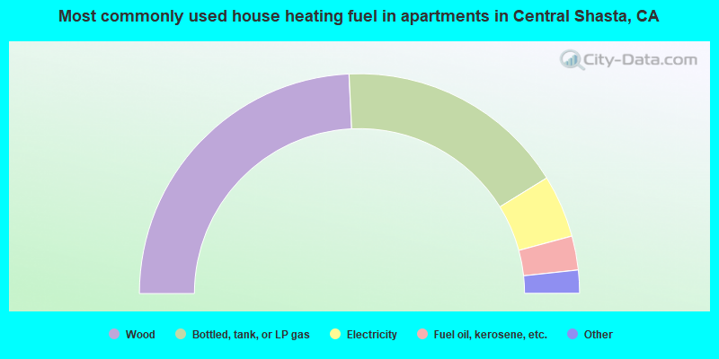
- 48.5%Wood
- 33.9%Bottled, tank, or LP gas
- 9.2%Electricity
- 5.0%Fuel oil, kerosene, etc.
- 2.0%Other fuel
- 1.4%Utility gas
Central Shasta compared to California state average:
- Median house value below state average.
- Black race population percentage significantly below state average.
- Hispanic race population percentage significantly below state average.
- Median age significantly above state average.
- Foreign-born population percentage significantly below state average.
- Renting percentage significantly below state average.
- Length of stay since moving in significantly above state average.
- Number of rooms per house significantly below state average.
- House age significantly below state average.
- Percentage of population with a bachelor's degree or higher below state average.
Central Shasta on our top lists:
- #8 on the list of "Top 101 cities with largest percentage of females in occupations: other healthcare support occupations (population 5,000+)"
- #29 on the list of "Top 101 cities with largest percentage of females in occupations: construction laborers (population 5,000+)"
- #39 on the list of "Top 101 cities with largest percentage of females in industries: farm product raw materials merchant wholesalers (population 5,000+)"
- #53 on the list of "Top 101 cities with largest percentage of females in industries: private households (population 5,000+)"
- #54 on the list of "Top 101 cities with largest percentage of females in industries: sewing, needlework, and piece goods stores (population 5,000+)"
- #55 on the list of "Top 101 cities with largest percentage of females in occupations: farmers and farm managers (population 5,000+)"
- #59 on the list of "Top 101 cities with largest percentage of males in occupations: farmers and farm managers (population 5,000+)"
- #69 on the list of "Top 101 cities with largest percentage of males in occupations: supervisors of construction and extraction workers (population 5,000+)"
- #72 on the list of "Top 101 cities with largest percentage of males in occupations: counselors, social workers, and other community and social service specialists (population 5,000+)"
- #77 on the list of "Top 101 cities with largest percentage of females in industries: nonmetallic mineral products (population 5,000+)"
- #79 on the list of "Top 101 cities with largest percentage of females in industries: metals and minerals, except petroleum, merchant wholesalers (population 5,000+)"
- #82 on the list of "Top 100 cities with largest land areas"
- #88 on the list of "Top 101 cities with largest percentage of males in industries: petroleum and petroleum products merchant wholesalers (population 5,000+)"
- #88 on the list of "Top 101 cities with largest percentage of females in industries: repair and maintenance (population 5,000+)"
- #23 on the list of "Top 101 counties with the largest increase in the number of births per 1000 residents 2000-2006 to 2007-2013 (pop 50,000+)"
- #27 on the list of "Top 101 counties with the smallest number of children under 18 without health insurance coverage in 2000 (pop. 50,000+)"
- #55 on the list of "Top 101 counties with the lowest Particulate Matter (PM2.5) Annual air pollution readings in 2012 (µg/m3)"
- #60 on the list of "Top 101 counties with the largest increase in the number of deaths per 1000 residents 2000-2006 to 2007-2013 (pop. 50,000+)"
- #66 on the list of "Top 101 counties with the lowest Particulate Matter (PM10) Annual air pollution readings in 2012 (µg/m3)"