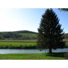
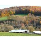
Butternuts, New York

Submit your own pictures of this town and show them to the world
- OSM Map
- Google Map
- MSN Map
Population change since 2000: -0.3%
 |
| Males: 882 | |
| Females: 904 |
| Median resident age: | 48.2 years |
| New York median age: | 40.7 years |
Zip codes: 13776.
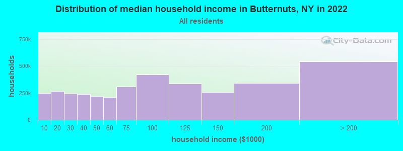
| Butternuts: | $77,935 |
| NY: | $79,557 |
Estimated per capita income in 2022: $39,753 (it was $19,223 in 2000)
Butternuts town income, earnings, and wages data
Estimated median house or condo value in 2022: $175,665 (it was $75,300 in 2000)
| Butternuts: | $175,665 |
| NY: | $400,400 |
Mean prices in 2022: all housing units: $228,779; detached houses: $247,959; townhouses or other attached units: $313,844; in 2-unit structures: $212,590; in 3-to-4-unit structures: $357,277; in 5-or-more-unit structures: $928,498; mobile homes: $87,717
Detailed information about poverty and poor residents in Butternuts, NY
Compare current foreclosures near Butternuts, NY:
| Photo | Address | Area | Beds / Baths | Price | Details |
|---|---|---|---|---|---|

|
#1
N Washington Ave
Oxford, NY 13830
|
2,234 sq. feet
|
2 baths 4 beds |
$121,500
|
show details |

|
#2
Mill Creek Rd
Otego, NY 13825
|
1,210 sq. feet
|
1 baths 3 beds |
$34,900
|
show details |

|
#3
State Highway 8
Masonville, NY 13804
|
1,320 sq. feet
|
1 baths 4 beds |
$24,900
|
show details |

|
#4
Henry St
Norwich, NY 13815
|
2,560 sq. feet
|
1 baths 3 beds |
$17,900
|
show details |

|
#5
Orchard St
Oneonta, NY 13820
|
1,144 sq. feet
|
3 baths 3 beds |
show details | |

|
#6
Main St
Franklin, NY 13775
|
2,400 sq. feet
|
2 baths 4 beds |
show details | |

|
#7
Ritton St
Sidney, NY 13838
|
900 sq. feet
|
1 baths 3 beds |
show details | |

|
#8
Johnston Cir
Sidney, NY 13838
|
1,152 sq. feet
|
2 baths 2 beds |
show details | |

|
#9
Chestnut St
Oneonta, NY 13820
|
924 sq. feet
|
2 baths 3 beds |
show details | |

|
#10
Eric St
Norwich, NY 13815
|
864 sq. feet
|
1 baths 3 beds |
show details |
| Photo | Address | Area | Beds / Baths | Price | Details |
|---|---|---|---|---|---|

|
#11
Commercial St
Gilbertsville, NY 13776
|
5 sq. feet
|
2 baths 6 beds |
show details | |

|
#12
Canasawacta St
Norwich, NY 13815
|
2,410 sq. feet
|
4 baths 4 beds |
show details | |

|
#13
Chestnut St
Oneonta, NY 13820
|
1,192 sq. feet
|
2 baths 3 beds |
show details | |

|
#14
Canasawacta St
Norwich, NY 13815
|
1,386 sq. feet
|
1 baths 3 beds |
show details | |

|
#15
Fair St
Norwich, NY 13815
|
2,234 sq. feet
|
2 baths 3 beds |
show details | |

|
#16
Rexford St
Norwich, NY 13815
|
1,608 sq. feet
|
2 baths 3 beds |
show details | |

|
#17
Division St
Norwich, NY 13815
|
1,947 sq. feet
|
2 baths 4 beds |
show details | |

|
#18
Union St
Sidney, NY 13838
|
1,364 sq. feet
|
2 baths 4 beds |
show details | |

|
#19
Campmeeting St
Sidney, NY 13838
|
1,479 sq. feet
|
2 baths 4 beds |
show details | |

|
#20
Sharon St
Sidney, NY 13838
|
1,619 sq. feet
|
2 baths 4 beds |
show details |
| Photo | Address | Area | Beds / Baths | Price | Details |
|---|---|---|---|---|---|

|
#21
State Highway 12
Norwich, NY 13815
|
1,769 sq. feet
|
2 baths 4 beds |
show details | |

|
#22
Morgan Acres Rd
Norwich, NY 13815
|
960 sq. feet
|
1 baths 2 beds |
show details | |

|
#23
Clinton St
Oneonta, NY 13820
|
1,916 sq. feet
|
2 baths 3 beds |
show details | |

|
#24
Jay St
Sidney Center, NY 13839
|
630 sq. feet
|
1 baths 2 beds |
show details | |

|
#25
Birch St
Oneonta, NY 13820
|
1,862 sq. feet
|
4 baths 4 beds |
show details | |

|
#26
Academy St
Oneonta, NY 13820
|
1,872 sq. feet
|
3 baths 5 beds |
show details | |

|
#27
Baker Rd
Sidney Center, NY 13839
|
1,360 sq. feet
|
2 baths 3 beds |
show details | |

|
#28
Stapleton Ave
Oneonta, NY 13820
|
1,088 sq. feet
|
2 baths 3 beds |
show details | |

|
#29
Youngman Ave
Oneonta, NY 13820
|
1,080 sq. feet
|
2 baths 3 beds |
show details | |

|
#30
Rose Ave
Oneonta, NY 13820
|
1,344 sq. feet
|
1 baths 3 beds |
show details |
| Photo | Address | Area | Beds / Baths | Price | Details |
|---|---|---|---|---|---|

|
#31
Scott St
Oxford, NY 13830
|
2,840 sq. feet
|
2 baths 4 beds |
show details | |

|
#32
Parker Hollow Rd
Unadilla, NY 13849
|
1,232 sq. feet
|
2 baths 3 beds |
show details | |

|
#33
Alice St
Oxford, NY 13830
|
1,162 sq. feet
|
1 baths 3 beds |
show details | |

|
#34
State Highway 220
Oxford, NY 13830
|
1,937 sq. feet
|
1 baths 4 beds |
show details | |

|
#35
Division St
Norwich, NY 13815
|
2,113 sq. feet
|
2 baths 3 beds |
show details | |

|
#36
Chestnut St
Sidney, NY 13838
|
1,086 sq. feet
|
1 baths 2 beds |
show details | |

|
#37
Diamond St
Norwich, NY 13815
|
1,436 sq. feet
|
2 baths 3 beds |
show details | |

|
#38
Moss St
New Berlin, NY 13411
|
808 sq. feet
|
1 baths 3 beds |
show details | |

|
#39
County Road 35
Guilford, NY 13780
|
1,800 sq. feet
|
1 baths 3 beds |
show details | |

|
#40
Walnut St
Norwich, NY 13815
|
1,869 sq. feet
|
2 baths 2 beds |
show details |
| Photo | Address | Area | Beds / Baths | Price | Details |
|---|---|---|---|---|---|

|
#41
Main St
Unadilla, NY 13849
|
3,608 sq. feet
|
4 baths 5 beds |
show details | |

|
#42
Clifton St
Unadilla, NY 13849
|
1,608 sq. feet
|
1 baths 4 beds |
show details | |

|
#43
Broad St
Morris, NY 13808
|
4,112 sq. feet
|
3 baths 6 beds |
show details | |

|
#44
County Road 36
Guilford, NY 13780
|
988 sq. feet
|
2 baths 4 beds |
show details | |

|
#45
Sheldon St
Norwich, NY 13815
|
1,844 sq. feet
|
1 baths 3 beds |
show details | |

|
#46
Old County Road 43
Bainbridge, NY 13733
|
1,230 sq. feet
|
1 baths 4 beds |
show details | |

|
#47
Wells Bridge Rd
Otego, NY 13825
|
1,092 sq. feet
|
2 baths 4 beds |
show details | |

|
#48
County Road 31
Norwich, NY 13815
|
1,040 sq. feet
|
1 baths 3 beds |
show details | |

|
#49
State Highway 23
Morris, NY 13808
|
1,512 sq. feet
|
2 baths 3 beds |
show details | |

|
Check over 1 million property listings on Foreclosure.com!
|
browse all offers | |||

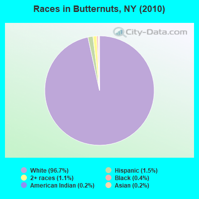
- 1,72796.7%White alone
- 271.5%Hispanic
- 191.1%Two or more races
- 70.4%Black alone
- 30.2%American Indian alone
- 30.2%Asian alone
Races in Butternuts detailed stats: ancestries, foreign born residents, place of birth
 Recent articles from our blog. Our writers, many of them Ph.D. graduates or candidates, create easy-to-read articles on a wide variety of topics.
Ancestries: German (19.6%), English (19.0%), Irish (17.5%), Italian (10.0%), United States (6.1%), Dutch (5.5%).
Current Local Time: EST time zone
Land area: 54.1 square miles.
Population density: 33 people per square mile (very low).
26 residents are foreign born
| This town: | 1.5% |
| New York: | 20.4% |
| Butternuts town: | 1.8% ($1,335) |
| New York: | 1.9% ($2,847) |
Nearest city with pop. 50,000+: Utica, NY  (43.4 miles , pop. 60,651).
Nearest city with pop. 200,000+: Rochester, NY (125.8 miles , pop. 219,773).
Nearest city with pop. 1,000,000+: Bronx, NY (135.0 miles , pop. 1,332,650).
Nearest cities:
), Latitude: 42.47 N, Longitude: 75.32 W
Area code commonly used in this area: 607
| Here: | 4.7% |
| New York: | 4.4% |
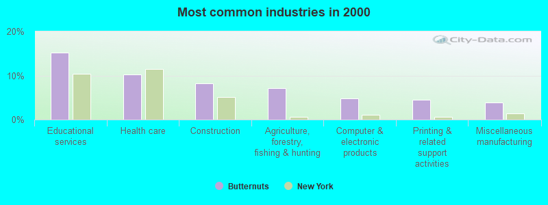
- Educational services (15.2%)
- Health care (10.3%)
- Construction (8.2%)
- Agriculture, forestry, fishing & hunting (7.1%)
- Computer & electronic products (4.8%)
- Printing & related support activities (4.5%)
- Miscellaneous manufacturing (3.8%)
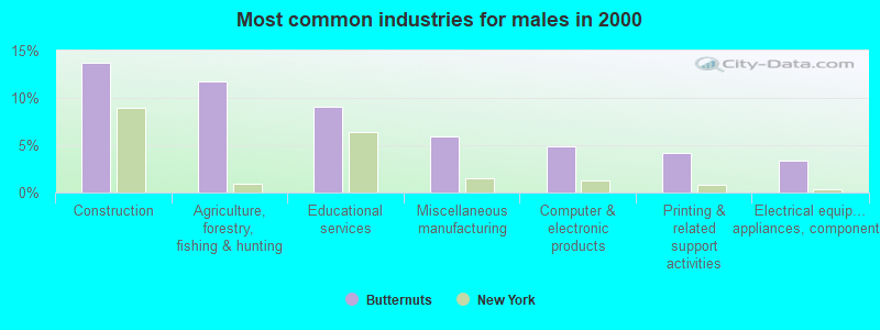
- Construction (13.7%)
- Agriculture, forestry, fishing & hunting (11.7%)
- Educational services (9.1%)
- Miscellaneous manufacturing (6.0%)
- Computer & electronic products (4.9%)
- Printing & related support activities (4.2%)
- Electrical equipment, appliances, components (3.3%)
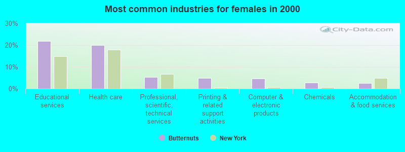
- Educational services (21.9%)
- Health care (20.0%)
- Professional, scientific, technical services (5.4%)
- Printing & related support activities (4.9%)
- Computer & electronic products (4.7%)
- Chemicals (2.7%)
- Accommodation & food services (2.5%)
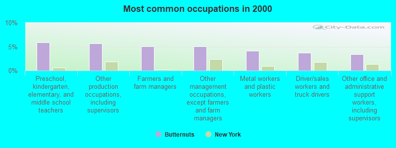
- Preschool, kindergarten, elementary, and middle school teachers (5.8%)
- Other production occupations, including supervisors (5.7%)
- Farmers and farm managers (5.0%)
- Other management occupations, except farmers and farm managers (5.0%)
- Metal workers and plastic workers (4.1%)
- Driver/sales workers and truck drivers (3.7%)
- Other office and administrative support workers, including supervisors (3.4%)
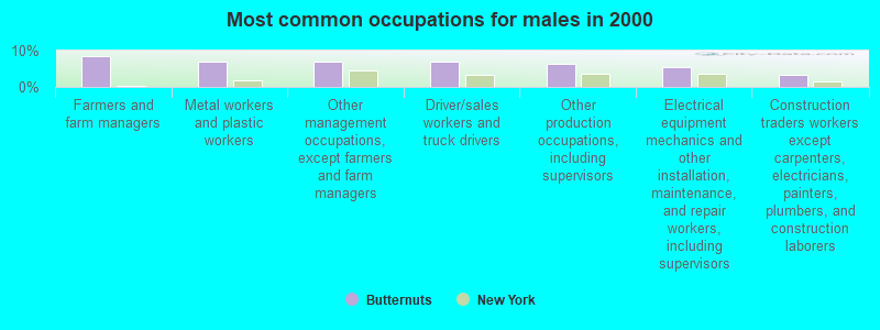
- Farmers and farm managers (8.6%)
- Metal workers and plastic workers (7.1%)
- Other management occupations, except farmers and farm managers (7.1%)
- Driver/sales workers and truck drivers (7.1%)
- Other production occupations, including supervisors (6.4%)
- Electrical equipment mechanics and other installation, maintenance, and repair workers, including supervisors (5.5%)
- Construction traders workers except carpenters, electricians, painters, plumbers, and construction laborers (3.3%)
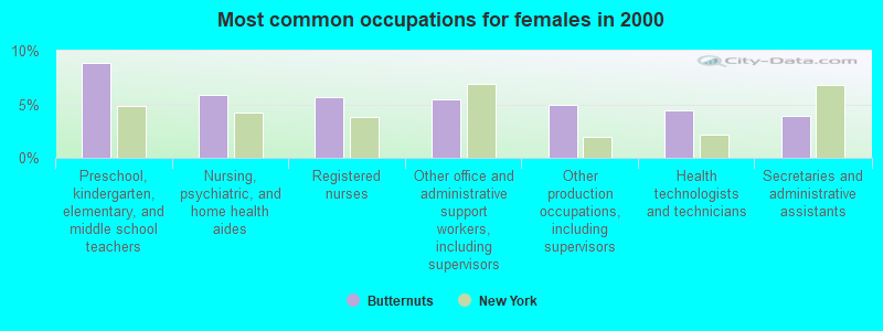
- Preschool, kindergarten, elementary, and middle school teachers (8.9%)
- Nursing, psychiatric, and home health aides (5.9%)
- Registered nurses (5.7%)
- Other office and administrative support workers, including supervisors (5.4%)
- Other production occupations, including supervisors (4.9%)
- Health technologists and technicians (4.4%)
- Secretaries and administrative assistants (3.9%)
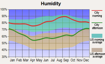
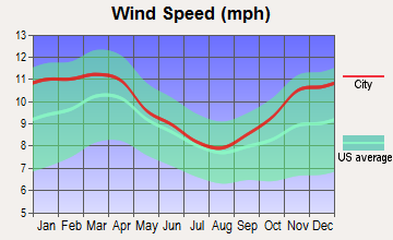
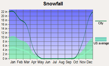
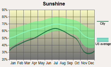
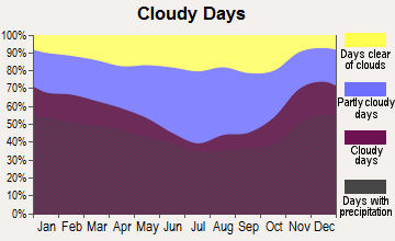
Average climate in Butternuts, New York
Based on data reported by over 4,000 weather stations


Tornado activity:
Butternuts-area historical tornado activity is slightly below New York state average. It is 66% smaller than the overall U.S. average.
On 5/31/1998, a category F3 (max. wind speeds 158-206 mph) tornado 11.9 miles away from the Butternuts town center injured 3 people and caused $800,000 in damages.
On 7/10/1989, a category F4 (max. wind speeds 207-260 mph) tornado 47.2 miles away from the town center injured 20 people and caused between $5,000,000 and $50,000,000 in damages.
Earthquake activity:
Butternuts-area historical earthquake activity is significantly above New York state average. It is 67% smaller than the overall U.S. average.On 10/7/1983 at 10:18:46, a magnitude 5.3 (5.1 MB, 5.3 LG, 5.1 ML, Class: Moderate, Intensity: VI - VII) earthquake occurred 113.7 miles away from the city center
On 4/20/2002 at 10:50:47, a magnitude 5.3 (5.3 ML, Depth: 3.0 mi) earthquake occurred 162.9 miles away from Butternuts center
On 4/20/2002 at 10:50:47, a magnitude 5.2 (5.2 MB, 4.2 MS, 5.2 MW, 5.0 MW) earthquake occurred 160.9 miles away from Butternuts center
On 8/23/2011 at 17:51:04, a magnitude 5.8 (5.8 MW, Depth: 3.7 mi) earthquake occurred 344.5 miles away from the city center
On 6/17/1991 at 08:53:16, a magnitude 4.1 (4.0 MB, 4.0 LG, Depth: 3.1 mi, Class: Light, Intensity: IV - V) earthquake occurred 34.5 miles away from Butternuts center
On 1/16/1994 at 01:49:16, a magnitude 4.6 (4.6 MB, 4.6 LG, Depth: 3.1 mi) earthquake occurred 152.8 miles away from the city center
Magnitude types: regional Lg-wave magnitude (LG), body-wave magnitude (MB), local magnitude (ML), surface-wave magnitude (MS), moment magnitude (MW)
Natural disasters:
The number of natural disasters in Otsego County (22) is greater than the US average (15).Major Disasters (Presidential) Declared: 13
Emergencies Declared: 7
Causes of natural disasters: Storms: 10, Floods: 8, Hurricanes: 3, Snowstorms: 2, Tropical Storms: 2, Blizzard: 1, Ice Storm: 1, Power Outage: 1, Tornado: 1, Wind: 1, Winter Storm: 1, Other: 2 (Note: some incidents may be assigned to more than one category).
Hospitals and medical centers near Butternuts:
- VALLEY VIEW MANOR NURSING HOME (Nursing Home, about 11 miles away; NORWICH, NY)
- HOSPICE OF CHENANGO COUNTY (Hospital, about 12 miles away; NORWICH, NY)
- CHENANGO MEMORIAL HOSPITAL, INC Acute Care Hospitals (about 12 miles away; NORWICH, NY)
- NORWICH REHABILITATION AND NURSING CENTER (Nursing Home, about 12 miles away; NORWICH, NY)
- CHESTNUT PARK AND REHABILITATION NURSING CENTER (Nursing Home, about 13 miles away; ONEONTA, NY)
- BASSETT HEALTHCARE (Dialysis Facility, about 13 miles away; ONEONTA, NY)
- THE HOSPITAL (Hospital, about 13 miles away; SIDNEY, NY)
Colleges/universities with over 2000 students nearest to Butternuts:
- SUNY Oneonta (about 14 miles; Oneonta, NY; Full-time enrollment: 6,081)
- SUNY College of Technology at Delhi (about 25 miles; Delhi, NY; FT enrollment: 2,911)
- Colgate University (about 27 miles; Hamilton, NY; FT enrollment: 3,094)
- Morrisville State College (about 33 miles; Morrisville, NY; FT enrollment: 2,823)
- SUNY Broome Community College (about 39 miles; Binghamton, NY; FT enrollment: 4,969)
- Herkimer County Community College (about 42 miles; Herkimer, NY; FT enrollment: 2,774)
- Mohawk Valley Community College (about 43 miles; Utica, NY; FT enrollment: 5,693)
Points of interest:
Notable locations in Butternuts: Seefield Farm (A), Kinnie Ridge Farm (B), Southwind Farms (C), Church Corners (D), Gilbertsville Free Library (E). Display/hide their locations on the map
Cemeteries: Prentiss Cemetery (1), Mann Cemetery (2), Upton Park Cemetery (3), Old Churchyard Cemetery (4), Brookside Cemetery (5), Hollis Cemetery (6), Butternut Valley Cemetery (7). Display/hide their locations on the map
Swamps: Black Ash Bog (A). Display/hide its location on the map
Streams, rivers, and creeks: Dunderberg Creek (A), Dry Brook (B), Butternut Creek (C), Coye Brook (D), Halbert Brook (E), Thorp Brook (F), Shaw Brook (G), Cahoon Creek (H). Display/hide their locations on the map
| This town: | 2.3 people |
| New York: | 2.6 people |
| This town: | 68.2% |
| Whole state: | 63.5% |
| This town: | 8.0% |
| Whole state: | 6.8% |
Likely homosexual households (counted as self-reported same-sex unmarried-partner households)
- Lesbian couples: 0.1% of all households
- Gay men: 0.1% of all households
| This town: | 8.6% |
| Whole state: | 14.6% |
| This town: | 2.9% |
| Whole state: | 7.4% |
For population 15 years and over in Butternuts:
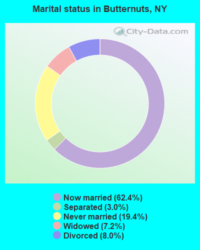
- Never married: 19.4%
- Now married: 62.4%
- Separated: 3.0%
- Widowed: 7.2%
- Divorced: 8.0%
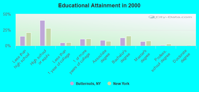
For population 25 years and over in Butternuts:
- High school or higher: 85.0%
- Bachelor's degree or higher: 20.4%
- Graduate or professional degree: 8.0%
- Unemployed: 5.0%
- Mean travel time to work (commute): 30.0 minutes
| Here: | 9.7 |
| New York average: | 14.2 |
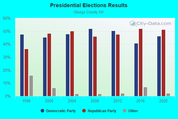
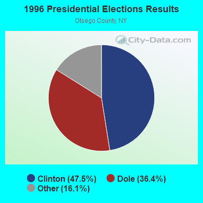
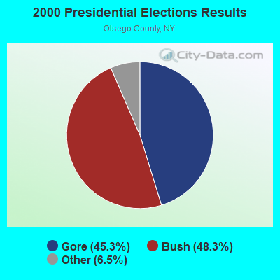
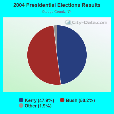
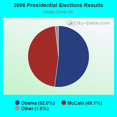
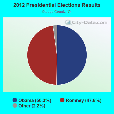
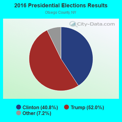
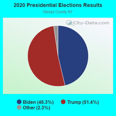
Graphs represent county-level data. Detailed 2008 Election Results
Religion statistics for Butternuts, NY (based on Otsego County data)
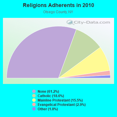
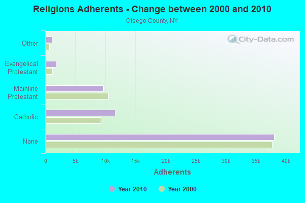
| Religion | Adherents | Congregations |
|---|---|---|
| Catholic | 11,599 | 6 |
| Mainline Protestant | 9,637 | 69 |
| Evangelical Protestant | 1,829 | 26 |
| Other | 1,094 | 9 |
| Orthodox | 25 | 1 |
| None | 38,075 | - |
Food Environment Statistics:
| Otsego County: | 2.89 / 10,000 pop. |
| New York: | 4.13 / 10,000 pop. |
| Here: | 0.32 / 10,000 pop. |
| New York: | 0.06 / 10,000 pop. |
| This county: | 0.96 / 10,000 pop. |
| State: | 0.92 / 10,000 pop. |
| Here: | 5.62 / 10,000 pop. |
| New York: | 1.68 / 10,000 pop. |
| This county: | 9.96 / 10,000 pop. |
| State: | 8.82 / 10,000 pop. |
| Here: | 7.7% |
| New York: | 8.2% |
| Otsego County: | 24.6% |
| New York: | 23.8% |
| Here: | 15.6% |
| State: | 15.6% |
Strongest AM radio stations in Butternuts:
- WCHN (970 AM; 1 kW; NORWICH, NY; Owner: BANJO COMMUNICATIONS GROUP, INC)
- WGY (810 AM; 50 kW; SCHENECTADY, NY; Owner: CLEAR CHANNEL BROADCASTING LICENSES, INC.)
- WCDO (1490 AM; 1 kW; SIDNEY, NY; Owner: CDO BROADCASTING, INC.)
- WDLA (1270 AM; 5 kW; WALTON, NY; Owner: BANJO COMMUNICATIONS GROUP, INC.)
- WPTR (1540 AM; 50 kW; ALBANY, NY; Owner: KIMTRON, INC.)
- WINR (680 AM; 5 kW; BINGHAMTON, NY; Owner: CLEVELAND RADIO LICENSES, LLC)
- WDOS (730 AM; 1 kW; ONEONTA, NY; Owner: ULTIMATE B/CASTING NETWORK, INC.)
- WMCA (570 AM; 50 kW; NEW YORK, NY; Owner: SALEM MEDIA OF NEW YORK, LLC)
- WNNZ (640 AM; 50 kW; WESTFIELD, MA; Owner: CLEAR CHANNEL BROADCASTING LICENSES, INC.)
- WNBF (1290 AM; 9 kW; BINGHAMTON, NY; Owner: CITADEL BROADCASTING COMPANY)
- WABC (770 AM; 50 kW; NEW YORK, NY; Owner: WABC-AM RADIO, INC.)
- WOR (710 AM; 50 kW; NEW YORK, NY; Owner: BUCKLEY BROADCASTING CORPORATION)
- WFAN (660 AM; 50 kW; NEW YORK, NY; Owner: INFINITY BROADCASTING OPERATIONS, INC.)
Strongest FM radio stations in Butternuts:
- WBKT (95.3 FM; NORWICH, NY; Owner: BANJO COMMUNICATIONS GROUP, INC)
- WKXZ (93.9 FM; NORWICH, NY; Owner: BANJO COMMUNICATIONS GROUP, INC)
- WCDO-FM (100.9 FM; SIDNEY, NY; Owner: CDO BROADCASTING, INC.)
- WSRK (103.9 FM; ONEONTA, NY; Owner: ULTIMATE B/CASTING NETWORK, INC.)
- WSQC-FM (91.7 FM; ONEONTA, NY; Owner: WSKG PUBLIC TELECOMM. COUNCIL)
- WZOZ (103.1 FM; ONEONTA, NY; Owner: BANJO COMMUNICATIONS GROUP, INC)
- WGKR (105.3 FM; GRAND GORGE, NY; Owner: SOUND OF LIFE, INC.)
- WDHI (100.3 FM; DELHI, NY; Owner: BANJO COMMUNICATIONS GROUP, INC.)
- WHWK (98.1 FM; BINGHAMTON, NY; Owner: CITADEL BROADCASTING COMPANY)
- WDLA-FM (92.1 FM; WALTON, NY; Owner: BANJO COMMUNICATIONS GROUP, INC.)
- WJIV (101.9 FM; CHERRY VALLEY, NY; Owner: CHRISTIAN BROADCASTING SYSTEM, LTD.)
- WAAL (99.1 FM; BINGHAMTON, NY; Owner: CITADEL BROADCASTING COMPANY)
- WSKG-FM (89.3 FM; BINGHAMTON, NY; Owner: WSKG PUB.TELECOMMUNICATIONS COUNCIL)
- WMXW (103.3 FM; VESTAL, NY; Owner: CLEAR CHANNEL BROADCASTING LICENSES, INC.)
- WIYN (94.7 FM; DEPOSIT, NY; Owner: BANJO COMMUNICATIONS GROUP, INC.)
- WSQX-FM (91.5 FM; BINGHAMTON, NY; Owner: WSKG PUBLIC TELECOMMUNICATIONS CNCL.)
- WIFF (90.1 FM; BINGHAMTON, NY; Owner: CSN INTERNATIONAL)
- WKGB-FM (92.5 FM; CONKLIN, NY; Owner: CLEAR CHANNEL BROADCASTING LICENSES, INC.)
- W214AT (90.7 FM; SIDNEY, NY; Owner: FAMILY LIFE RADIO MINISTRIES, INC.)
TV broadcast stations around Butternuts:
- WFXV (Channel 33; UTICA, NY; Owner: QUORUM OF UTICA LICENSE, LLC)
- WSKG-TV (Channel 46; BINGHAMTON, NY; Owner: WSKG PUBLIC TELECOMMUNICATIONS COUNCIL)
- WISF-LP (Channel 15; ONEONTA, NY; Owner: RASTUS BROADCAST)
- W29BJ (Channel 29; BURLINGTON, NY; Owner: KEVIN O'KANE)
- National Bridge Inventory (NBI) Statistics
- 8Number of bridges
- 62ft / 19.3mTotal length
- $11,132,000Total costs
- 3,666Total average daily traffic
- 294Total average daily truck traffic
- 4,477Total future (year 2037) average daily traffic
FCC Registered Antenna Towers:
4- Richard J Devlin, Flax Island Road (Lat: 42.457528 Lon: -75.233444), Type: 60.7, Overall height: 57.9 m, Registrant: Bluewing, Inc., Mark.Hoppe@bluewing.Com, , St. P-aul, Phone: (651) 699-1985
- Richard J Devlin, Flax Island Road (Lat: 42.457528 Lon: -75.233444), Type: 60.7, Overall height: 57.9 m, Registrant: Bluewing, Inc., Mark.Hoppe@bluewing.Com, , St. P-aul, Phone: (651) 699-1985
- Richard J Devlin, Rockdale Hill Off Lobdell Rd (Lat: 42.458056 Lon: -75.233611), Type: 36.2, Structure height: 36077 m, Overall height: 30.5 m, Registrant: County Of Otsego, Coope-rstown, Phone: (607) 547-5351
- Rockdale Hill Off Lobdell Rd (Lat: 42.458056 Lon: -75.233611), Type: 36.2, Overall height: 30.5 m, Registrant: County Of Otsego, Coope-rstown, Phone: (607) 547-5351
FCC Registered Broadcast Land Mobile Towers:
3- Lobdell Rd (Lat: 42.458139 Lon: -75.233500), Call Sign: KNAQ889,
Assigned Frequencies: 45.8800 MHz, 46.2200 MHz, 46.4400 MHz, Grant Date: 12/18/2020, Expiration Date: 01/23/2031, Registrant: Otsego County 911 Communications, 172 County Hwy 33w, Cooperstown, NY 13326, Phone: (607) 547-7530, Fax: (607) 547-6413, Email:
- 107 Duncan Lane (Lat: 42.458056 Lon: -75.233889), Type: Tower, Structure height: 28.9 m, Overall height: 731.5 m, Call Sign: WQBZ919, Licensee ID: L00064329,
Assigned Frequencies: 154.762 MHz, Grant Date: 01/13/2005, Expiration Date: 04/13/2005, Cancellation Date: 06/18/2005, Certifier: Roy J Althiser Jr, Registrant: Otsego County 911 Communications, 172 County Highway 33w, Cooperstown, NY 13326, Phone: (607) 547-5351, Fax: (607) 547-7529, Email:
- ROCKDALE, Flax Island Road (Lat: 42.457528 Lon: -75.233444), Type: Tower, Structure height: 57.9 m, Overall height: 60.7 m, Call Sign: WQPT849,
Assigned Frequencies: 154.762 MHz, Grant Date: 06/17/2022, Expiration Date: 08/14/2032, Certifier: Richard J Devlin, Registrant: Otsego County Sheriff, 172 Co Hwy 33w, Cooperstown, NY 13326, Phone: (607) 547-4271, Fax: (607) 547-6413, Email:
FCC Registered Microwave Towers:
3- STATION, Rockdale Hill Tower Lobdell Rd (Lat: 42.458111 Lon: -75.233500), Overall height: 30.5 m, Call Sign: WNEE298,
Assigned Frequencies: 2189.60 MHz, Grant Date: 02/18/2009, Expiration Date: 01/06/2019, Cancellation Date: 12/29/2010, Phone: (607) 547-5351
- STATION, Rockdale Hill Tower Lobdell Rd (Lat: 42.458111 Lon: -75.233500), Overall height: 30.5 m, Call Sign: WNEF802,
Assigned Frequencies: 2186.40 MHz, Grant Date: 03/28/2009, Expiration Date: 06/23/2019, Cancellation Date: 09/11/2012, Registrant: Otsego County Sheriff\'s 911 Communications, 172 County Highway 33w, Cooperstown, NY 13326, Phone: (607) 547-7530, Fax: (607) 547-6413, Email:
- ROCKDALE, Flax Island Road (Lat: 42.457611 Lon: -75.233528), Type: Ltower, Structure height: 57.9 m, Overall height: 60.7 m, Call Sign: WRCF355,
Assigned Frequencies: 928.512 MHz, 952.512 MHz, Grant Date: 09/17/2018, Expiration Date: 09/17/2028, Certifier: Robert J O'Brien, Registrant: Tait Communications, 15340 Park Row Drive, Houston, TX 77084, Phone: (814) 643-6959, Email:

- 61.7%Fuel oil, kerosene, etc.
- 19.0%Wood
- 12.2%Bottled, tank, or LP gas
- 4.5%Electricity
- 2.0%Utility gas
- 0.3%Coal or coke
- 0.3%Other fuel
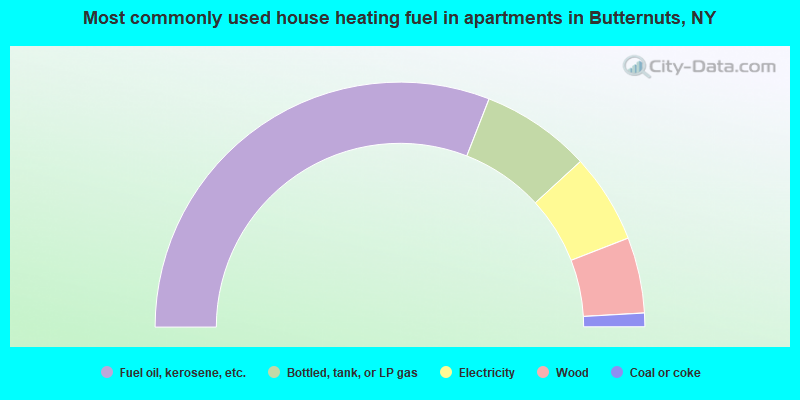
- 61.8%Fuel oil, kerosene, etc.
- 14.5%Bottled, tank, or LP gas
- 11.8%Electricity
- 10.0%Wood
- 1.8%Coal or coke
Butternuts compared to New York state average:
- Median house value significantly below state average.
- Unemployed percentage significantly below state average.
- Black race population percentage significantly below state average.
- Hispanic race population percentage significantly below state average.
- Median age above state average.
- Foreign-born population percentage significantly below state average.
- Renting percentage significantly below state average.
- Length of stay since moving in significantly above state average.
- Number of rooms per house significantly below state average.
- House age significantly below state average.
- Number of college students below state average.