Brantley, Alabama
Submit your own pictures of this town and show them to the world
- OSM Map
- General Map
- Google Map
- MSN Map
Population change since 2000: -12.9%
 |
| Males: 317 | |
| Females: 484 |
| Median resident age: | 39.7 years |
| Alabama median age: | 39.6 years |
Zip codes: 36009.
| Brantley: | $27,405 |
| AL: | $59,674 |
Estimated per capita income in 2022: $21,181 (it was $14,108 in 2000)
Brantley town income, earnings, and wages data
Estimated median house or condo value in 2022: $110,529 (it was $41,100 in 2000)
| Brantley: | $110,529 |
| AL: | $200,900 |
Mean prices in 2022: all housing units: $172,988; detached houses: $177,909; mobile homes: $80,733
Median gross rent in 2022: $359.
(17.0% for White Non-Hispanic residents, 20.3% for Black residents, 52.9% for two or more races residents)
Detailed information about poverty and poor residents in Brantley, AL
Compare current foreclosures near Brantley, AL:
| Photo | Address | Area | Beds / Baths | Price | Details |
|---|---|---|---|---|---|

|
#1
School Dr Apt 2
Brantley, AL 36009
|
- sq. feet
|
- baths - beds |
show details | |

|
#2
Dozier Hwy
Brantley, AL 36009
|
- sq. feet
|
- baths - beds |
show details | |

|
#3
Stricklin Rd
Brantley, AL 36009
|
- sq. feet
|
- baths - beds |
show details | |

|
#4
Mulberry Rd
Brantley, AL 36009
|
- sq. feet
|
- baths - beds |
show details | |

|
#5
Georgiana Hwy
Brantley, AL 36009
|
- sq. feet
|
- baths - beds |
show details | |

|
#6
Wyatt St
Brantley, AL 36009
|
- sq. feet
|
- baths - beds |
show details | |

|
#7
E Emmett Ave Apt 96
Brantley, AL 36009
|
- sq. feet
|
- baths - beds |
show details | |

|
#8
Lower Bozeman Rd
Brantley, AL 36009
|
- sq. feet
|
- baths - beds |
show details | |

|
#9
Highway 141
Brantley, AL 36009
|
1,762 sq. feet
|
- baths - beds |
show details | |

|
#10
N Main St
Brantley, AL 36009
|
- sq. feet
|
- baths - beds |
show details |
| Photo | Address | Area | Beds / Baths | Price | Details |
|---|---|---|---|---|---|

|
#11
Elba Hwy
Brantley, AL 36009
|
- sq. feet
|
- baths - beds |
show details | |

|
#12
E Mill Ave
Brantley, AL 36009
|
- sq. feet
|
- baths - beds |
show details | |

|
#13
N Sasser St
Brantley, AL 36009
|
- sq. feet
|
- baths - beds |
show details | |

|
#14
School Dr Apt 43
Brantley, AL 36009
|
- sq. feet
|
- baths - beds |
show details | |

|
#15
Mulberry Rd
Brantley, AL 36009
|
- sq. feet
|
- baths - beds |
show details | |

|
#16
Wyatt St
Brantley, AL 36009
|
- sq. feet
|
- baths - beds |
show details | |

|
#17
Old Brantley Luverne Rd Lot 17
Brantley, AL 36009
|
- sq. feet
|
- baths - beds |
show details | |

|
#18
Taylor Ave
Elba, AL 36323
|
1,549 sq. feet
|
2 baths 2 beds |
$31,750
|
show details |

|
#19
County Road 315
Elba, AL 36323
|
900 sq. feet
|
1 baths 2 beds |
show details | |

|
#20
Claxton Ave N
Elba, AL 36323
|
2,246 sq. feet
|
2 baths 3 beds |
show details |
| Photo | Address | Area | Beds / Baths | Price | Details |
|---|---|---|---|---|---|

|
#21
Forest Ave
Elba, AL 36323
|
1,569 sq. feet
|
2 baths - beds |
show details | |

|
#22
Halso Mill Rd
Greenville, AL 36037
|
2,508 sq. feet
|
2 baths - beds |
show details | |

|
#23
Highway 87
Troy, AL 36079
|
2,814 sq. feet
|
1 baths - beds |
show details | |

|
#24
County Road 219
Elba, AL 36323
|
2,027 sq. feet
|
1 baths - beds |
show details | |

|
#25
County Road 409
Elba, AL 36323
|
1,848 sq. feet
|
1 baths - beds |
show details | |

|
#26
Highway 87
Troy, AL 36079
|
- sq. feet
|
- baths - beds |
show details | |

|
#27
Larkin Rd
Elba, AL 36323
|
- sq. feet
|
- baths - beds |
show details | |

|
#28
Stoudemire St
Elba, AL 36323
|
- sq. feet
|
- baths - beds |
show details | |

|
#29
Cottle Creek Rd
Andalusia, AL 36421
|
- sq. feet
|
- baths - beds |
show details | |

|
#30
Sunset Blvd
Elba, AL 36323
|
- sq. feet
|
1 baths - beds |
show details |
| Photo | Address | Area | Beds / Baths | Price | Details |
|---|---|---|---|---|---|

|
#31
Carver Dr
Elba, AL 36323
|
1,008 sq. feet
|
- baths - beds |
show details | |

|
#32
Montgomery Hwy
Luverne, AL 36049
|
1,128 sq. feet
|
- baths - beds |
show details | |

|
#33
Highway 87
Troy, AL 36079
|
- sq. feet
|
- baths - beds |
show details | |

|
#34
Morrow Ave
Elba, AL 36323
|
1,632 sq. feet
|
- baths - beds |
show details | |

|
#35
County Road 318
Jack, AL 36346
|
- sq. feet
|
- baths - beds |
show details | |

|
#36
S Us Highway 29
Goshen, AL 36035
|
- sq. feet
|
- baths - beds |
show details | |

|
#37
County Road 205
Jack, AL 36346
|
- sq. feet
|
- baths - beds |
show details | |

|
#38
Antioch Rd
Andalusia, AL 36421
|
- sq. feet
|
- baths - beds |
show details | |

|
#39
Us Highway 331
Opp, AL 36467
|
- sq. feet
|
- baths - beds |
show details | |

|
#40
Old Curtis Rd
Elba, AL 36323
|
- sq. feet
|
- baths - beds |
show details |
| Photo | Address | Area | Beds / Baths | Price | Details |
|---|---|---|---|---|---|

|
#41
Jones Cir
Elba, AL 36323
|
- sq. feet
|
- baths - beds |
show details | |

|
#42
Highway 87
Elba, AL 36323
|
- sq. feet
|
- baths - beds |
show details | |

|
#43
Claxton Ave N
Elba, AL 36323
|
- sq. feet
|
- baths - beds |
show details | |

|
#44
Atkins Rd
Opp, AL 36467
|
- sq. feet
|
- baths - beds |
show details | |

|
#45
Bond Ln
Opp, AL 36467
|
- sq. feet
|
- baths - beds |
show details | |

|
#46
Us Highway 331
Opp, AL 36467
|
- sq. feet
|
- baths - beds |
show details | |

|
#47
Lindsey St
Elba, AL 36323
|
- sq. feet
|
- baths - beds |
show details | |

|
#48
Highway 87
Jack, AL 36346
|
- sq. feet
|
- baths - beds |
show details | |

|
#49
Jeffcoat Rd
Rutledge, AL 36071
|
- sq. feet
|
- baths - beds |
show details | |

|
Check over 1 million property listings on Foreclosure.com!
|
browse all offers | |||


- 49352.7%White alone
- 37339.9%Black alone
- 414.4%Asian alone
- 222.4%Two or more races

According to our research of Alabama and other state lists, there were 9 registered sex offenders living in Brantley, Alabama as of May 02, 2024.
The ratio of all residents to sex offenders in Brantley is 101 to 1.
Type |
2009 |
2010 |
2011 |
2012 |
2013 |
2014 |
2015 |
2016 |
2017 |
2018 |
2019 |
2020 |
2021 |
2022 |
|---|---|---|---|---|---|---|---|---|---|---|---|---|---|---|
| Murders (per 100,000) | 0 (0.0) | 0 (0.0) | 0 (0.0) | 0 (0.0) | 0 (0.0) | 0 (0.0) | 0 (0.0) | 0 (0.0) | 0 (0.0) | 0 (0.0) | 0 (0.0) | 0 (0.0) | 0 (0.0) | 0 (0.0) |
| Rapes (per 100,000) | 0 (0.0) | 0 (0.0) | 0 (0.0) | 0 (0.0) | 0 (0.0) | 0 (0.0) | 0 (0.0) | 0 (0.0) | 0 (0.0) | 0 (0.0) | 0 (0.0) | 0 (0.0) | 0 (0.0) | 0 (0.0) |
| Robberies (per 100,000) | 0 (0.0) | 0 (0.0) | 0 (0.0) | 0 (0.0) | 0 (0.0) | 0 (0.0) | 0 (0.0) | 0 (0.0) | 0 (0.0) | 0 (0.0) | 0 (0.0) | 0 (0.0) | 0 (0.0) | 0 (0.0) |
| Assaults (per 100,000) | 3 (329.7) | 0 (0.0) | 2 (246.0) | 1 (123.3) | 1 (122.0) | 0 (0.0) | 0 (0.0) | 0 (0.0) | 0 (0.0) | 0 (0.0) | 1 (128.4) | 0 (0.0) | 0 (0.0) | 1 (125.3) |
| Burglaries (per 100,000) | 1 (109.9) | 0 (0.0) | 1 (123.0) | 0 (0.0) | 3 (365.9) | 3 (369.9) | 0 (0.0) | 6 (745.3) | 0 (0.0) | 1 (127.4) | 1 (128.4) | 0 (0.0) | 2 (267.0) | 1 (125.3) |
| Thefts (per 100,000) | 8 (879.1) | 0 (0.0) | 2 (246.0) | 0 (0.0) | 1 (122.0) | 2 (246.6) | 2 (247.2) | 4 (496.9) | 0 (0.0) | 0 (0.0) | 4 (513.5) | 1 (130.9) | 0 (0.0) | 1 (125.3) |
| Auto thefts (per 100,000) | 0 (0.0) | 0 (0.0) | 0 (0.0) | 0 (0.0) | 0 (0.0) | 0 (0.0) | 2 (247.2) | 0 (0.0) | 0 (0.0) | 3 (382.2) | 0 (0.0) | 0 (0.0) | 0 (0.0) | 0 (0.0) |
| Arson (per 100,000) | 0 (0.0) | 0 (0.0) | 1 (123.0) | 0 (0.0) | 0 (0.0) | 0 (0.0) | 0 (0.0) | 0 (0.0) | 0 (0.0) | 0 (0.0) | 0 (0.0) | 0 (0.0) | 0 (0.0) | 0 (0.0) |
| City-Data.com crime index | 108.8 | 0.0 | 67.7 | 24.7 | 54.9 | 35.8 | 29.7 | 72.0 | 0.0 | 39.5 | 55.2 | 5.2 | 18.7 | 38.8 |
The City-Data.com crime index weighs serious crimes and violent crimes more heavily. Higher means more crime, U.S. average is 246.1. It adjusts for the number of visitors and daily workers commuting into cities.
Crime rate in Brantley detailed stats: murders, rapes, robberies, assaults, burglaries, thefts, arson
Full-time law enforcement employees in 2021, including police officers: 5 (5 officers - 5 male; 0 female).
| Officers per 1,000 residents here: | 6.68 |
| Alabama average: | 2.40 |
 Recent articles from our blog. Our writers, many of them Ph.D. graduates or candidates, create easy-to-read articles on a wide variety of topics.


 | Tan SUVs unmarked (police or trooper vehicles) on I59??? (6 replies) |
Latest news from Brantley, AL collected exclusively by city-data.com from local newspapers, TV, and radio stations
Ancestries: American (13.3%), English (7.6%), African (6.4%), Scotch-Irish (1.3%).
Current Local Time: CST time zone
Elevation: 295 feet
Land area: 3.16 square miles.
Population density: 253 people per square mile (very low).

30 residents are foreign born (3.2% Asia).
| This town: | 3.2% |
| Alabama: | 3.5% |
| Brantley town: | 0.5% ($199) |
| Alabama: | 0.4% ($289) |
Nearest city with pop. 50,000+: Montgomery, AL  (53.8 miles , pop. 201,568).
Nearest city with pop. 1,000,000+: Houston, TX (557.2 miles , pop. 1,953,631).
Nearest cities:
), ), ), ), ), ), )Latitude: 31.58 N, Longitude: 86.26 W
Area code: 334

Single-family new house construction building permits:
- 2006: 1 building, cost: $200,000
- 2005: 1 building, cost: $275,000
- 2004: 1 building, cost: $275,000
- 2003: 1 building, cost: $275,000
- 2002: 2 buildings, average cost: $175,000
- 2001: 2 buildings, average cost: $125,000


| Here: | 3.0% |
| Alabama: | 2.6% |

- Health care (12.5%)
- Educational services (10.7%)
- Public administration (8.7%)
- Agriculture, forestry, fishing & hunting (4.9%)
- Construction (4.9%)
- Food & beverage stores (4.6%)
- Accommodation & food services (4.3%)

- Public administration (15.1%)
- Agriculture, forestry, fishing & hunting (9.5%)
- Construction (9.5%)
- Educational services (6.1%)
- Textile mills & textile products (4.5%)
- Transportation equipment (4.5%)
- Machinery (3.9%)

- Health care (23.5%)
- Educational services (15.7%)
- Food & beverage stores (8.4%)
- Accommodation & food services (6.0%)
- Finance & insurance (5.4%)
- Apparel (5.4%)
- Wood products (4.2%)

- Cashiers (6.4%)
- Building and grounds cleaning and maintenance occupations (5.2%)
- Preschool, kindergarten, elementary, and middle school teachers (4.6%)
- Law enforcement workers, including supervisors (4.6%)
- Other office and administrative support workers, including supervisors (4.3%)
- Registered nurses (4.1%)
- Other production occupations, including supervisors (4.1%)

- Law enforcement workers, including supervisors (7.8%)
- Building and grounds cleaning and maintenance occupations (6.7%)
- Vehicle and mobile equipment mechanics, installers, and repairers (6.7%)
- Fishing, hunting, and forestry occupations (6.1%)
- Other office and administrative support workers, including supervisors (4.5%)
- Laborers and material movers, hand (4.5%)
- Assemblers and fabricators (3.9%)

- Cashiers (10.2%)
- Registered nurses (8.4%)
- Preschool, kindergarten, elementary, and middle school teachers (7.2%)
- Nursing, psychiatric, and home health aides (6.6%)
- Cooks and food preparation workers (4.8%)
- Other production occupations, including supervisors (4.8%)
- Other office and administrative support workers, including supervisors (4.2%)
Average climate in Brantley, Alabama
Based on data reported by over 4,000 weather stations


(lower is better)

Lead (Pb) [µg/m3] level in 2007 was 0.230. This is significantly worse than average. Closest monitor was 21.7 miles away from the city center.
| City: | 0.230 |
| U.S.: | 0.009 |
Tornado activity:
Brantley-area historical tornado activity is slightly below Alabama state average. It is 44% greater than the overall U.S. average.
On 4/18/1969, a category F4 (max. wind speeds 207-260 mph) tornado 27.8 miles away from the Brantley town center killed 2 people and injured 14 people and caused between $50,000 and $500,000 in damages.
On 3/1/2007, a category F4 tornado 28.9 miles away from the town center killed 9 people and injured 50 people and caused $250 million in damages.
Earthquake activity:
Brantley-area historical earthquake activity is significantly above Alabama state average. It is 38% greater than the overall U.S. average.On 10/24/1997 at 08:35:17, a magnitude 4.9 (4.8 MB, 4.2 MS, 4.9 LG, Depth: 6.2 mi, Class: Light, Intensity: IV - V) earthquake occurred 67.9 miles away from the city center
On 1/18/1999 at 07:00:53, a magnitude 4.8 (4.8 MB, 4.0 LG, Depth: 0.6 mi) earthquake occurred 138.7 miles away from Brantley center
On 4/29/2003 at 08:59:39, a magnitude 4.9 (4.4 MB, 4.6 MW, 4.9 LG) earthquake occurred 204.5 miles away from the city center
On 11/7/2004 at 11:20:21, a magnitude 4.3 (4.3 MW, Depth: 3.1 mi) earthquake occurred 122.7 miles away from Brantley center
On 6/24/1975 at 11:11:36, a magnitude 4.5 (4.5 MB) earthquake occurred 174.1 miles away from the city center
On 4/29/2003 at 08:59:39, a magnitude 4.6 (4.6 MW, Depth: 12.3 mi) earthquake occurred 204.5 miles away from the city center
Magnitude types: regional Lg-wave magnitude (LG), body-wave magnitude (MB), surface-wave magnitude (MS), moment magnitude (MW)
Natural disasters:
The number of natural disasters in Crenshaw County (22) is greater than the US average (15).Major Disasters (Presidential) Declared: 13
Emergencies Declared: 6
Causes of natural disasters: Storms: 11, Floods: 9, Hurricanes: 8, Tornadoes: 7, Winds: 5, Drought: 1, Snowfall: 1, Winter Storm: 1, Other: 1 (Note: some incidents may be assigned to more than one category).

Colleges/universities with over 2000 students nearest to Brantley:
- Troy University (about 24 miles; Troy, AL; Full-time enrollment: 16,148)
- Enterprise State Community College (about 32 miles; Enterprise, AL; FT enrollment: 2,101)
- George C Wallace State Community College-Dothan (about 51 miles; Dothan, AL; FT enrollment: 3,611)
- Alabama State University (about 54 miles; Montgomery, AL; FT enrollment: 5,457)
- Auburn University at Montgomery (about 55 miles; Montgomery, AL; FT enrollment: 4,092)
- Faulkner University (about 56 miles; Montgomery, AL; FT enrollment: 2,887)
- Tuskegee University (about 67 miles; Tuskegee, AL; FT enrollment: 2,810)
Public high school in Brantley:
- BRANTLEY HIGH SCH (Students: 596, Location: 8879 N MAIN ST, Grades: PK-12)
Points of interest:
Notable location: Brantley Fire and Rescue (A). Display/hide its location on the map
Churches in Brantley include: Brantley Baptist Church (A), Brantley United Methodist Church (B). Display/hide their locations on the map
Cemeteries: Davis Cemetery (1), Brantley Cemetery (2). Display/hide their locations on the map
Creek: Moody Mill Creek (A). Display/hide its location on the map
Park in Brantley: Brantley Stadium (1). Display/hide its location on the map
Birthplace of: Wesley Person - Basketball player.
Drinking water stations with addresses in Brantley that have no violations reported:
- SOUTH CRENSHAW COUNTY WATER AUTHORITY (Population served: 5,490, Primary Water Source Type: Groundwater)
- BRANTLEY WATER WORKS (Population served: 1,485, Primary Water Source Type: Groundwater)
| This town: | 2.2 people |
| Alabama: | 2.5 people |
| This town: | 60.4% |
| Whole state: | 67.8% |
| This town: | 3.6% |
| Whole state: | 4.7% |
Likely homosexual households (counted as self-reported same-sex unmarried-partner households)
- Lesbian couples: 0.3% of all households
- Gay men: 0.0% of all households
Banks with branches in Brantley (2011 data):
- Brantley Bank and Trust Company: Brantley Bank And Trust Company at 9402 North Main Street, branch established on 1946/03/06. Info updated 2006/11/03: Bank assets: $65.1 mil, Deposits: $53.9 mil, local headquarters, positive income, 2 total offices, Holding Company: Brantley Bancorp, Inc.
For population 15 years and over in Brantley:

- Never married: 29.7%
- Now married: 38.6%
- Separated: 5.1%
- Widowed: 6.3%
- Divorced: 20.3%
For population 25 years and over in Brantley:
- High school or higher: 88.3%
- Bachelor's degree or higher: 19.1%
- Graduate or professional degree: 9.3%
- Unemployed: 3.6%
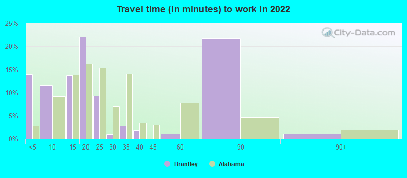
- Mean travel time to work (commute): 43.7 minutes


| Here: | 10.4 |
| Alabama average: | 11.5 |
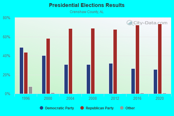
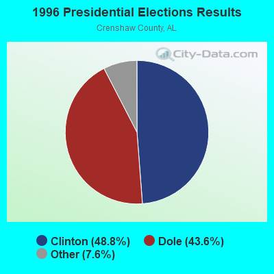
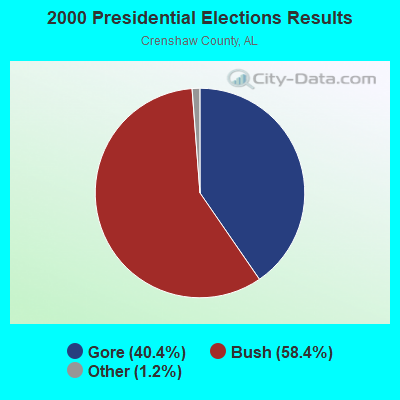
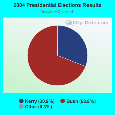
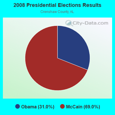


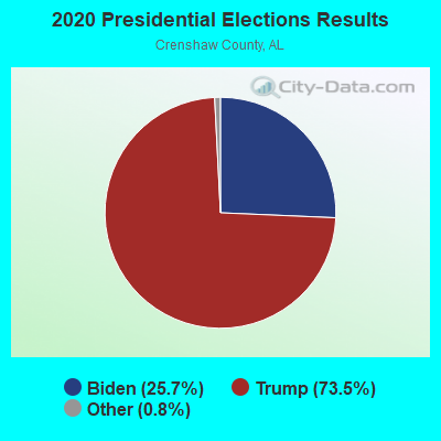
Graphs represent county-level data. Detailed 2008 Election Results
Religion statistics for Brantley, AL (based on Crenshaw County data)
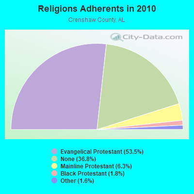
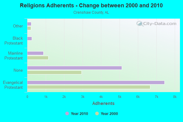
| Religion | Adherents | Congregations |
|---|---|---|
| Evangelical Protestant | 7,442 | 52 |
| Mainline Protestant | 875 | 13 |
| Black Protestant | 244 | 2 |
| Other | 223 | 1 |
| None | 5,122 | - |
Food Environment Statistics:
| Here: | 4.36 / 10,000 pop. |
| Alabama: | 1.89 / 10,000 pop. |
| This county: | 7.99 / 10,000 pop. |
| Alabama: | 6.32 / 10,000 pop. |
| Crenshaw County: | 5.08 / 10,000 pop. |
| State: | 5.75 / 10,000 pop. |
| This county: | 12.4% |
| Alabama: | 11.8% |
| This county: | 34.6% |
| State: | 31.7% |
| Crenshaw County: | 18.7% |
| Alabama: | 13.5% |
Health and Nutrition:
| Brantley: | 46.9% |
| Alabama: | 49.0% |
| Brantley: | 43.0% |
| Alabama: | 45.7% |
| Brantley: | 29.7 |
| Alabama: | 28.9 |
| Here: | 24.3% |
| State: | 20.7% |
| This city: | 17.1% |
| Alabama: | 11.0% |
| This city: | 6.8 |
| Alabama: | 6.8 |
| Brantley: | 37.1% |
| Alabama: | 34.4% |
| Brantley: | 49.1% |
| Alabama: | 55.2% |
| Brantley: | 78.0% |
| State: | 79.3% |
More about Health and Nutrition of Brantley, AL Residents
| Local government employment and payroll (March 2022) | |||||
| Function | Full-time employees | Monthly full-time payroll | Average yearly full-time wage | Part-time employees | Monthly part-time payroll |
|---|---|---|---|---|---|
| Police Protection - Officers | 4 | $17,606 | $52,818 | 0 | $0 |
| Judicial and Legal | 3 | $6,111 | $24,444 | 0 | $0 |
| Streets and Highways | 2 | $4,548 | $27,288 | 1 | $1,732 |
| Solid Waste Management | 2 | $3,676 | $22,056 | 0 | $0 |
| Parks and Recreation | 1 | $5,686 | $68,232 | 0 | $0 |
| Firefighters | 1 | $585 | $7,020 | 0 | $0 |
| Financial Administration | 1 | $4,176 | $50,112 | 1 | $1,426 |
| Sewerage | 1 | $3,538 | $42,456 | 0 | $0 |
| Water Supply | 1 | $5,686 | $68,232 | 0 | $0 |
| Local Libraries | 0 | $0 | 1 | $413 | |
| Other Government Administration | 0 | $0 | 7 | $661 | |
| Welfare | 0 | $0 | 3 | $3,073 | |
| Totals for Government | 16 | $51,613 | $38,710 | 13 | $7,305 |
Brantley government finances - Expenditure in 2021 (per resident):
- Assistance and Subsidies - Public Welfare, Federal Categorical Assistance Programs: $2,000 ($2.50)
- Current Operations - General - Other: $767,000 ($957.55)
Police Protection: $249,000 ($310.86)
Central Staff Services: $132,000 ($164.79)
Solid Waste Management: $32,000 ($39.95)
Local Fire Protection: $23,000 ($28.71)
Judicial and Legal Services: $16,000 ($19.98)
Toll Highways: $14,000 ($17.48)
Water Utilities: $13,000 ($16.23)
Sewerage: $13,000 ($16.23)
Financial Administration: $12,000 ($14.98)
Libraries: $8,000 ($9.99)
Regular Highways: $5,000 ($6.24)
Protective Inspection and Regulation - Other: $1,000 ($1.25)
- Intergovernmental to Local - Other - General - Other: $85,000 ($106.12)
- Total Salaries and Wages: $767,000 ($957.55)
Brantley government finances - Revenue in 2021 (per resident):
- Charges - Solid Waste Management: $115,000 ($143.57)
Sewerage: $64,000 ($79.90)
- Local Intergovernmental - Other: $34,000 ($42.45)
- Miscellaneous - Fines and Forfeits: $968,000 ($1208.49)
Rents: $1,000 ($1.25)
- Revenue - Water Utilities: $107,000 ($133.58)
- Tax - General Sales and Gross Receipts: $275,000 ($343.32)
Public Utilities Sales: $47,000 ($58.68)
Alcoholic Beverage Sales: $29,000 ($36.20)
Other License: $24,000 ($29.96)
Tobacco Products Sales: $18,000 ($22.47)
Motor Fuels Sales: $16,000 ($19.98)
Brantley government finances - Debt in 2021 (per resident):
- Long Term Debt - Outstanding Unspecified Public Purpose: $355,000 ($443.20)
Beginning Outstanding - Unspecified Public Purpose: $355,000 ($443.20)
Outstanding Nonguaranteed - Industrial Revenue: $120,000 ($149.81)
Beginning Outstanding - Public Debt for Private Purpose: $120,000 ($149.81)
Brantley government finances - Cash and Securities in 2021 (per resident):
- Other Funds - Cash and Securities: $505,000 ($630.46)
- Sinking Funds - Cash and Securities: $120,000 ($149.81)
Strongest AM radio stations in Brantley:
- WTBF (970 AM; 5 kW; TROY, AL; Owner: TROY BROADCASTING CORP.)
- WQLS (1200 AM; 10 kW; OZARK, AL; Owner: STYLES BROADCASTING OF DOTHAN, INC.)
- WASG (550 AM; 25 kW; ATMORE, AL; Owner: 550 AM, INC)
- WOPP (1290 AM; 2 kW; OPP, AL; Owner: E. & R BROADCASTING, INC.)
- WMSP (740 AM; 10 kW; MONTGOMERY, AL; Owner: CUMULUS LICENSING CORP.)
- WJOX (690 AM; 50 kW; BIRMINGHAM, AL; Owner: CITADEL BROADCASTING COMPANY)
- WELB (1350 AM; 1 kW; ELBA, AL; Owner: ELBA RADIO COMPANY)
- WAMI (860 AM; 1 kW; OPP, AL; Owner: THE OPP BROADCASTING CO., INC.)
- WDJC (850 AM; 50 kW; BIRMINGHAM, AL; Owner: KIMTRON, INC.)
- WTKN (1560 AM; daytime; 5 kW; DALEVILLE, AL; Owner: JOSEPH A. ADAMS, SR.)
- WEBY (1330 AM; 25 kW; MILTON, FL; Owner: SPINNAKER LICENSE CORPORATION)
- WACV (1170 AM; 10 kW; MONTGOMERY, AL; Owner: MONTGOMERY BROADCAST PROPERTIES, LTD)
- WOOF (560 AM; 5 kW; DOTHAN, AL; Owner: WOOF, INC.)
Strongest FM radio stations in Brantley:
- WQLD (104.3 FM; LUVERNE, AL; Owner: CAPSTAR TX LIMITED PARTNERSHIP)
- WZHT (105.7 FM; TROY, AL; Owner: CAPSTAR TX LIMITED PARTNERSHIP)
- WKMX (106.7 FM; ENTERPRISE, AL; Owner: WKMX, INC.)
- WAOQ (100.3 FM; BRANTLEY, AL; Owner: ALATRON CORPORATION, INC.)
- WZTZ (101.1 FM; ELBA, AL; Owner: ELBA RADIO COMPANY)
- WLWI-FM (92.3 FM; MONTGOMERY, AL; Owner: CUMULUS LICENSING CORP.)
- WAXU (91.1 FM; TROY, AL; Owner: AMERICAN FAMILY ASSOCIATION)
- WFXX (107.7 FM; GEORGIANA, AL; Owner: JEFFREY K. HAYNES)
- WAPR (88.3 FM; SELMA, AL; Owner: UA-ASU-TSU EDUCATIONAL RADIO CORP.)
- WSTF (91.5 FM; ANDALUSIA, AL; Owner: MONTGOMERY CHRISTIAN EDUC. RADIO,INC)
- WTBF-FM (94.7 FM; BRUNDIDGE, AL; Owner: TROY BROADCASTING CORPORATION)
- WPGG (93.3 FM; EVERGREEN, AL; Owner: GULF COAST BROADCASTING COMPANY, INC)
- WTSU (89.9 FM; MONTGOMERY-TROY, AL; Owner: TROY STATE UNIVERSITY)
- WKXN (95.9 FM; GREENVILLE, AL; Owner: AUTAUGAVILLE RADIO, INC.)
- WRJM-FM (93.7 FM; GENEVA, AL; Owner: STAGE DOOR DEVELOPMENT, INC.)
- WAMI-FM (102.3 FM; OPP, AL; Owner: THE OPP BROADCASTING CO., INC.)
- W218AO (91.5 FM; ANDALUSIA, AL; Owner: FAITH BROADCASTING, INC)
TV broadcast stations around Brantley:
- WDIQ (Channel 2; DOZIER, AL; Owner: ALABAMA EDUCATIONAL TELEVISION COMMISSION)
- WRJM-TV (Channel 67; TROY, AL; Owner: JOSIE PARK BROADCASTING, INC.)
- WSFA (Channel 12; MONTGOMERY, AL; Owner: LIBCO, INC.)
- WCOV-TV (Channel 20; MONTGOMERY, AL; Owner: WOODS COMMUNICATIONS CORPORATION)
- WAKA (Channel 8; SELMA, AL; Owner: ALABAMA BROADCASTING PARTNERS)
- WTVY (Channel 4; DOTHAN, AL; Owner: GRAY MIDAMERICA TV LICENSEE CORP.)
- WNCF (Channel 32; MONTGOMERY, AL; Owner: CHANNEL 32 MONTGOMERY LLC)
- W19BV (Channel 19; ANDALUSIA, AL; Owner: LOFLIN CHILDREN'S TRUST - FOUR)
- W36BQ (Channel 36; ANDALUSIA, AL; Owner: LOFLIN CHILDREN'S TRUST - FOUR)
- W40BE (Channel 40; ANDALUSIA, AL; Owner: DAVID M. LOFLIN)
- W49BM (Channel 49; ANDALUSIA, AL; Owner: DAVID M. LOFLIN)
- W57CC (Channel 57; ANDALUSIA, AL; Owner: LOFLIN CHILDREN'S TRUST - FOUR)
- W59CQ (Channel 59; ANDALUSIA, AL; Owner: LOFLIN CHILDREN'S TRUST - FOUR)
- W65CW (Channel 65; ANDALUSIA, AL; Owner: DAVID M. LOFLIN)
Brantley fatal accident list:
Jun 22, 2002 05:45 PM, Us-Sr9, Vehicles: 2, Persons: 3, Fatalities: 1
Jan 9, 1995 05:15 AM, Sr15, Vehicles: 1, Persons: 3, Pedestrians: 2, Fatalities: 1
Mar 14, 1982 06:50 PM, 0021, Vehicles: 2, Persons: 4, Fatalities: 1, Drunk persons involved: 1
- National Bridge Inventory (NBI) Statistics
- 20Number of bridges
- 184ft / 55.7mTotal length
- $23,664,000Total costs
- 33,172Total average daily traffic
- 4,413Total average daily truck traffic
- 45,016Total future (year 2033) average daily traffic

- New bridges - historical statistics
- 11920-1929
- 21930-1939
- 11940-1949
- 31950-1959
- 21960-1969
- 21970-1979
- 31980-1989
- 61990-1999
FCC Registered Cell Phone Towers:
1 (See the full list of FCC Registered Cell Phone Towers in Brantley)FCC Registered Antenna Towers:
58 (See the full list of FCC Registered Antenna Towers)FCC Registered Broadcast Land Mobile Towers:
3- Police Dept Bldg W Emmett St (Lat: 31.583500 Lon: -86.258278), Call Sign: KSS797, Licensee ID: L00007127,
Assigned Frequencies: 155.010 MHz, Grant Date: 11/22/1995, Expiration Date: 12/17/2000, Cancellation Date: 02/18/2001, Registrant: Brantley, Town Of, Brantley, AL 36009, Phone: (205) 527-8624
- Well 4 Bryan Ave. (Lat: 31.586000 Lon: -86.258278), Type: Mast, Structure height: 3 m, Overall height: 5 m, Call Sign: WPMB855,
Assigned Frequencies: 453.137 MHz, Grant Date: 04/05/2013, Expiration Date: 05/20/2023, Cancellation Date: 07/22/2023, Certifier: Larry P Morgan, Registrant: Apco Telecommunications Services, 2040 S Ridgewood Ave, South Daytona, FL 32119, Fax: (904) 322-2502
- Covington Electric Ofc Hwy 331 (Lat: 31.569889 Lon: -86.252722), Call Sign: WNWP496, Licensee ID: L00003541,
Assigned Frequencies: 457.350 MHz, Grant Date: 05/25/2001, Expiration Date: 06/14/2011, Cancellation Date: 08/20/2011, Registrant: Powersouth Energy Cooperative, 2027 E. Three Notch Street, Andalusia, AL 36420, Phone: (334) 427-3000, Fax: (334) 427-3439, Email:
FCC Registered Microwave Towers:
3- HOST RCC, Opp Hwy (028149) (Lat: 31.461250 Lon: -86.263472), Type: Gtower, Structure height: 76.8 m, Overall height: 79.3 m, Call Sign: WQPF585,
Assigned Frequencies: 11285.0 MHz, 11365.0 MHz, 11245.0 MHz, 11075.0 MHz, 11155.0 MHz, 11075.0 MHz, 11155.0 MHz, 11075.0 MHz, 11155.0 MHz, 11075.0 MHz... (+15 more), Grant Date: 06/01/2022, Expiration Date: 05/02/2032, Certifier: Chris Harris, Registrant: Conterra Ultra Broadband LLC, 2101 Rexford Rd, Ste 200e, Charlotte, NC 28211, Phone: (704) 936-1801, Email:
- 9BH0632A, 975 Old Three Notch Road (Lat: 31.508500 Lon: -86.238083), Type: Gtower, Structure height: 100.6 m, Overall height: 103.6 m, Call Sign: WQWR971,
Assigned Frequencies: 11645.0 MHz, 11645.0 MHz, 11645.0 MHz, 11645.0 MHz, 11645.0 MHz, 11645.0 MHz, 11645.0 MHz, 11645.0 MHz, 11645.0 MHz, 11645.0 MHz, 11645.0 MHz, Grant Date: 11/03/2015, Expiration Date: 11/03/2025, Certifier: David Werblow, Registrant: T-Mobile License LLC, 12920 Se 38th St, Bellevue, WA 98006, Phone: (425) 383-8401, Fax: (425) 383-4040, Email:
- 9BH0627A, 8628 East Emmett Avenue (028160 / Brantley) (Lat: 31.584611 Lon: -86.252111), Type: Gtower, Structure height: 80.7 m, Overall height: 83.8 m, Call Sign: WQWS310,
Assigned Frequencies: 10855.0 MHz, 10855.0 MHz, 10855.0 MHz, 10855.0 MHz, 10855.0 MHz, 10855.0 MHz, 10855.0 MHz, 10855.0 MHz, Grant Date: 11/04/2015, Expiration Date: 11/04/2025, Cancellation Date: 06/22/2021, Certifier: David Werblow, Registrant: T-Mobile Usa, Inc., 12920 Se 38th Street, Bellevue, WA 98006, Phone: (425) 383-8401, Fax: (425) 383-4040, Email:
FCC Registered Amateur Radio Licenses:
4- Call Sign: KF7OMB, Licensee ID: L01624592, Grant Date: 01/05/2021, Expiration Date: 03/15/2031, Certifier: John Weakland, Registrant: John Weakland, 714 Cable Rd, Brantley, AL 36009
- Call Sign: KK4LCQ, Licensee ID: L01728817, Grant Date: 08/16/2012, Expiration Date: 08/16/2022, Cancellation Date: 03/30/2017, Certifier: Michael A Kolb, Registrant: Michael A Kolb, 1523 Williams Loop Road, Brantley, AL 36009
- Call Sign: KG4RND, Previous Call Sign: K4HKS, Licensee ID: L00168279, Grant Date: 10/20/2020, Expiration Date: 10/20/2030, Certifier: Henry K Sasser, Registrant: Henry K Sasser, 3450 Blackmon Road, Brantley, AL 36009
- Call Sign: KQ4PKB, Licensee ID: L02767009, Grant Date: 03/05/2024, Expiration Date: 03/05/2034, Certifier: Ashley T Stewart Sr, Registrant: Ashley T Stewart Sr, 9540 W Emmett Ave, Brantley, AL 36009
FAA Registered Aircraft:
1- Aircraft: HOLLAND ALLEN KITFOX LIGHT SQUARED (Category: Land, Seats: 2, Weight: Up to 12,499 Pounds), Engine: BOMBARDIER ROTAX (ALL) (Reciprocating)
N-Number: 357AR, N357AR, N-357AR, Serial Number: C0203-0279, Year manufactured: 2006, Airworthiness Date: 08/03/2006, Certificate Issue Date: 08/09/2005
Registrant (Individual): Allen Holland, 996 Wallace Rd, Brantley, AL 36009
2002 - 2018 National Fire Incident Reporting System (NFIRS) incidents
- Fire incident types reported to NFIRS in Brantley, AL
- 4236.5%Structure Fires
- 3833.0%Outside Fires
- 2622.6%Other
- 97.8%Mobile Property/Vehicle Fires
 According to the data from the years 2002 - 2018 the average number of fires per year is 7. The highest number of reported fires - 21 took place in 2004, and the least - 0 in 2006. The data has a rising trend.
 When looking into fire subcategories, the most incidents belonged to: Structure Fires (36.5%), and Outside Fires (33.0%).
| Most common first names in Brantley, AL among deceased individuals | ||
| Name | Count | Lived (average) |
|---|---|---|
| James | 36 | 74.0 years |
| Mary | 28 | 79.0 years |
| Willie | 22 | 72.4 years |
| John | 22 | 74.4 years |
| William | 20 | 78.9 years |
| Annie | 17 | 79.7 years |
| Walter | 13 | 72.9 years |
| Joe | 12 | 71.7 years |
| Robert | 11 | 69.4 years |
| Charlie | 11 | 74.5 years |
| Most common last names in Brantley, AL among deceased individuals | ||
| Last name | Count | Lived (average) |
|---|---|---|
| Johnson | 20 | 77.6 years |
| Taylor | 20 | 76.6 years |
| Morgan | 18 | 78.9 years |
| Williams | 17 | 75.2 years |
| Smith | 16 | 70.4 years |
| Hall | 16 | 75.3 years |
| Bryan | 16 | 71.6 years |
| Sasser | 15 | 77.8 years |
| Godwin | 14 | 79.1 years |
| Compton | 14 | 78.5 years |
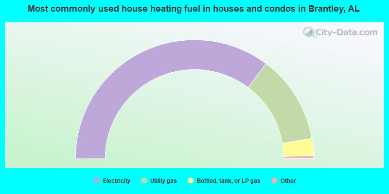
- 71.1%Electricity
- 24.2%Utility gas
- 4.7%Bottled, tank, or LP gas
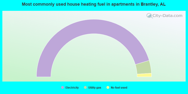
- 90.8%Electricity
- 7.2%Utility gas
- 2.0%No fuel used
Brantley compared to Alabama state average:
- Median household income below state average.
- Median house value below state average.
- Unemployed percentage significantly below state average.
- Hispanic race population percentage significantly below state average.
- Length of stay since moving in significantly above state average.