Big War Creek, Tennessee
Submit your own pictures of this place and show them to the world
- OSM Map
- General Map
- Google Map
- MSN Map

| Males: 908 | |
| Females: 928 |
| Median resident age: | 39.3 years |
| Tennessee median age: | 35.9 years |
Zip code: 37881
| Big War Creek: | $39,416 |
| TN: | $65,254 |
Estimated per capita income in 2022: $28,714 (it was $14,011 in 2000)
Big War Creek CCD income, earnings, and wages data
Estimated median house or condo value in 2022: $191,976 (it was $68,500 in 2000)
| Big War Creek: | $191,976 |
| TN: | $284,800 |
Mean prices in 2022: all housing units: $171,372; detached houses: $197,359; townhouses or other attached units: $99,839; mobile homes: $71,998
Detailed information about poverty and poor residents in Big War Creek, TN


- 1,82898.0%White alone
- 100.5%Black alone
- 100.5%Two or more races
- 60.3%Other race alone
- 30.2%American Indian alone
- 30.2%Asian alone
- 40.2%Hispanic
- 10.05%Native Hawaiian and Other
Pacific Islander alone

Races in Big War Creek detailed stats: ancestries, foreign born residents, place of birth
 Recent articles from our blog. Our writers, many of them Ph.D. graduates or candidates, create easy-to-read articles on a wide variety of topics.
Current Local Time: EST time zone
Land area: 64.4 square miles.
Population density: 28 people per square mile (very low).

| Big War Creek CCD: | 0.5% ($313) |
| Tennessee: | 0.8% ($715) |
Nearest city with pop. 50,000+: Johnson City, TN  (48.3 miles , pop. 55,469).
Nearest city with pop. 200,000+: Fayette, KY (129.3 miles , pop. 260,512).
Nearest city with pop. 1,000,000+: Chicago, IL (442.3 miles , pop. 2,896,016).
Nearest cities:
), ), ), )Latitude: 36.46 N, Longitude: 83.23 W
Area code commonly used in this area: 423


| Here: | 3.8% |
| Tennessee: | 3.0% |

- Educational services (15.8%)
- Construction (12.3%)
- Health care (8.7%)
- Public administration (6.7%)
- Furniture & related product manufacturing (6.0%)
- Transportation equipment (4.1%)
- Agriculture, forestry, fishing & hunting (3.7%)

- Construction (18.6%)
- Educational services (9.4%)
- Furniture & related product manufacturing (7.9%)
- Wood products (5.8%)
- Agriculture, forestry, fishing & hunting (5.6%)
- Truck transportation (5.6%)
- Public administration (5.6%)

- Educational services (26.4%)
- Health care (16.4%)
- Public administration (8.6%)
- Social assistance (5.4%)
- Textile mills & textile products (5.0%)
- Other direct selling establishments (4.6%)
- Administrative & support & waste management services (4.3%)

- Other management occupations, except farmers and farm managers (7.5%)
- Other production occupations, including supervisors (6.6%)
- Driver/sales workers and truck drivers (6.2%)
- Preschool, kindergarten, elementary, and middle school teachers (5.4%)
- Laborers and material movers, hand (4.6%)
- Carpenters (3.7%)
- Health technologists and technicians (3.2%)

- Driver/sales workers and truck drivers (9.9%)
- Other production occupations, including supervisors (8.4%)
- Other management occupations, except farmers and farm managers (6.9%)
- Carpenters (6.0%)
- Farmers and farm managers (5.1%)
- Laborers and material movers, hand (4.5%)
- Construction traders workers except carpenters, electricians, painters, plumbers, and construction laborers (4.1%)

- Preschool, kindergarten, elementary, and middle school teachers (9.3%)
- Other management occupations, except farmers and farm managers (8.6%)
- Textile, apparel, and furnishings workers (7.1%)
- Health technologists and technicians (6.4%)
- Registered nurses (5.0%)
- Laborers and material movers, hand (4.6%)
- Teachers, secondary school (4.3%)
Average climate in Big War Creek, Tennessee
Based on data reported by over 4,000 weather stations


(lower is better)

Air Quality Index (AQI) level in 2007 was 64.6. This is about average.
| City: | 64.6 |
| U.S.: | 72.6 |

Nitrogen Dioxide (NO2) [ppb] level in 2006 was 4.41. This is about average. Closest monitor was 11.4 miles away from the city center.
| City: | 4.41 |
| U.S.: | 5.11 |

Sulfur Dioxide (SO2) [ppb] level in 2007 was 4.34. This is significantly worse than average. Closest monitor was 11.4 miles away from the city center.
| City: | 4.34 |
| U.S.: | 1.51 |

Ozone [ppb] level in 2006 was 36.4. This is about average. Closest monitor was 11.4 miles away from the city center.
| City: | 36.4 |
| U.S.: | 33.3 |
Tornado activity:
Big War Creek-area historical tornado activity is significantly below Tennessee state average. It is 62% smaller than the overall U.S. average.
On 5/9/1988, a category F3 (max. wind speeds 158-206 mph) tornado 25.6 miles away from the Big War Creek place center killed one person and injured 15 people and caused between $5,000,000 and $50,000,000 in damages.
On 7/6/1980, a category F2 (max. wind speeds 113-157 mph) tornado 2.5 miles away from the place center caused between $50,000 and $500,000 in damages.
Earthquake activity:
Big War Creek-area historical earthquake activity is significantly above Tennessee state average. It is 51% greater than the overall U.S. average.On 7/27/1980 at 18:52:21, a magnitude 5.2 (5.1 MB, 4.7 MS, 5.0 UK, 5.2 UK, Class: Moderate, Intensity: VI - VII) earthquake occurred 127.3 miles away from Big War Creek center
On 8/9/2020 at 12:07:37, a magnitude 5.1 (5.1 MW, Depth: 4.7 mi) earthquake occurred 118.7 miles away from Big War Creek center
On 11/30/1973 at 07:48:41, a magnitude 4.7 (4.7 MB, 4.6 ML, Class: Light, Intensity: IV - V) earthquake occurred 61.2 miles away from the city center
On 8/23/2011 at 17:51:04, a magnitude 5.8 (5.8 MW, Depth: 3.7 mi) earthquake occurred 308.4 miles away from Big War Creek center
On 9/7/1988 at 02:28:09, a magnitude 4.6 (4.5 MB, 4.6 LG) earthquake occurred 122.1 miles away from Big War Creek center
On 8/2/1974 at 08:52:09, a magnitude 4.9 (4.3 MB, 4.9 LG) earthquake occurred 183.5 miles away from the city center
Magnitude types: regional Lg-wave magnitude (LG), body-wave magnitude (MB), local magnitude (ML), surface-wave magnitude (MS), moment magnitude (MW)
Natural disasters:
The number of natural disasters in Hancock County (14) is near the US average (15).Major Disasters (Presidential) Declared: 9
Emergencies Declared: 2
Causes of natural disasters: Floods: 8, Storms: 6, Winter Storms: 3, Tornadoes: 2, Fire: 1, Heavy Rain: 1, Hurricane: 1, Landslide: 1, Mudslide: 1, Snowfall: 1, Other: 1 (Note: some incidents may be assigned to more than one category).
Hospitals and medical centers near Big War Creek:
- HANCOCK COUNTY HOME HEALTH (Home Health Center, about 6 miles away; SNEEDVILLE, TN)
- HANCOCK MANOR NURSING HOME (Nursing Home, about 6 miles away; SNEEDVILLE, TN)
- WELLMONT HAWKINS COUNTY MEMORIAL HOSPITAL Acute Care Hospitals (about 13 miles away; ROGERSVILLE, TN)
- INTERIM HEALTH CARE OF EAST TENNESSEE (Home Health Center, about 15 miles away; MORRISTOWN, TN)
Colleges/universities with over 2000 students nearest to Big War Creek:
- Walters State Community College (about 17 miles; Morristown, TN; Full-time enrollment: 4,359)
- Lincoln Memorial University (about 26 miles; Harrogate, TN; FT enrollment: 3,706)
- Tusculum College (about 33 miles; Greeneville, TN; FT enrollment: 2,070)
- Southeast Kentucky Community and Technical College (about 38 miles; Cumberland, KY; FT enrollment: 2,196)
- Northeast State Community College (about 46 miles; Blountville, TN; FT enrollment: 4,480)
- East Tennessee State University (about 50 miles; Johnson City, TN; FT enrollment: 12,774)
- The University of Tennessee-Knoxville (about 53 miles; Knoxville, TN; FT enrollment: 25,483)
Points of interest:
Notable locations in Big War Creek: Flat Gap (A), Manning Ferry (B), Treadway Volunteer Fire Department (C), Chestnut Ridge Volunteer Fire Department (D). Display/hide their locations on the map
Churches in Big War Creek include: Rock Bridge Church (A), Union Church (B), Yellow Branch Church (C), War Creek Church (D), Chinquapin Church (E), Duck Creek Baptist Church (F). Display/hide their locations on the map
Cemeteries: Johnson Cemetery (1), Vaughn Cemetery (2), Winkler Cemetery (3), Adams Cemetery (4), Livesay Cemetery (5), Green Cemetery (6), Greene Cemetery (7). Display/hide their locations on the map
Streams, rivers, and creeks: Little War Creek (A), Flat Gap Creek (B), Fall Branch (C), Duck Creek (D), Cool Branch (E), Yellow Branch (F), Big War Creek (G), Wilder Branch (H), Stony Fork (I). Display/hide their locations on the map
| This place: | 2.5 people |
| Tennessee: | 2.5 people |
| This place: | 66.8% |
| Whole state: | 69.8% |
| This place: | 3.0% |
| Whole state: | 4.2% |
Likely homosexual households (counted as self-reported same-sex unmarried-partner households)
- Lesbian couples: 0.3% of all households
- Gay men: 0.1% of all households
| This place: | 22.6% |
| Whole state: | 13.5% |
| This place: | 11.0% |
| Whole state: | 5.8% |
For population 15 years and over in Big War Creek:

- Never married: 18.1%
- Now married: 64.8%
- Separated: 2.2%
- Widowed: 10.0%
- Divorced: 7.0%
For population 25 years and over in Big War Creek:
- High school or higher: 67.1%
- Bachelor's degree or higher: 14.9%
- Graduate or professional degree: 8.5%
- Unemployed: 2.1%
- Mean travel time to work (commute): 27.6 minutes


| Here: | 17.4 |
| Tennessee average: | 13.3 |

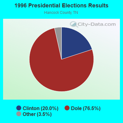
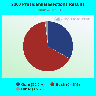
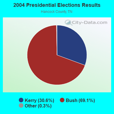
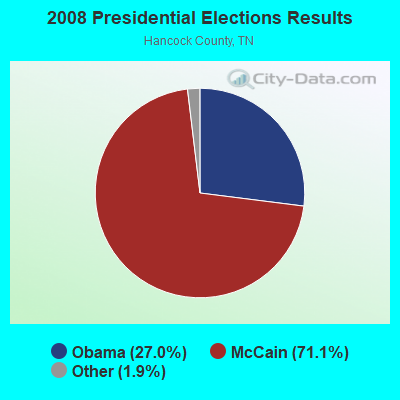
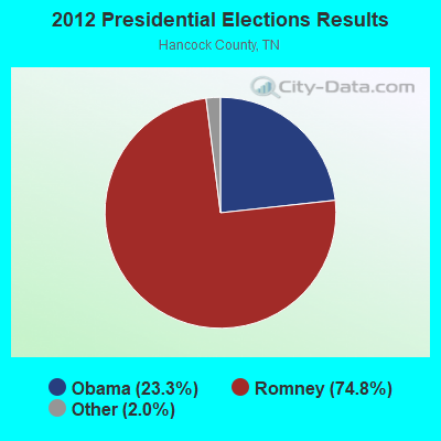
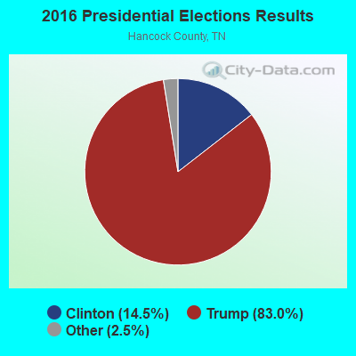

Graphs represent county-level data. Detailed 2008 Election Results
Religion statistics for Big War Creek, TN (based on Hancock County data)
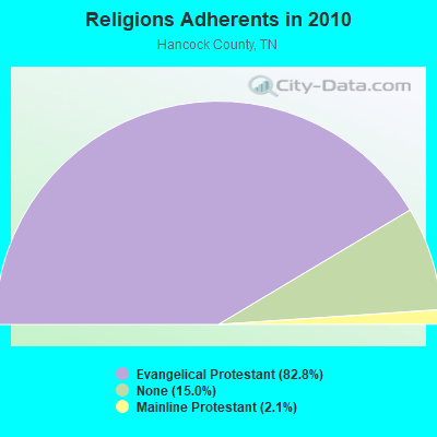
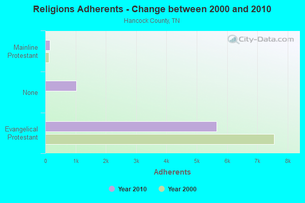
| Religion | Adherents | Congregations |
|---|---|---|
| Evangelical Protestant | 5,647 | 34 |
| Mainline Protestant | 144 | 2 |
| Catholic | 4 | 1 |
| None | 1,024 | - |
Food Environment Statistics:
| This county: | 2.98 / 10,000 pop. |
| Tennessee: | 1.99 / 10,000 pop. |
| Hancock County: | 4.47 / 10,000 pop. |
| Tennessee: | 5.16 / 10,000 pop. |
| Hancock County: | 1.49 / 10,000 pop. |
| Tennessee: | 6.56 / 10,000 pop. |
| Hancock County: | 11.5% |
| Tennessee: | 11.4% |
| This county: | 29.5% |
| Tennessee: | 30.2% |
| Hancock County: | 13.3% |
| Tennessee: | 13.5% |
Strongest AM radio stations in Big War Creek:
- WKVL (850 AM; daytime; 50 kW; KNOXVILLE, TN; Owner: HORNE RADIO, LLC)
- WCRK (1150 AM; 5 kW; MORRISTOWN, TN; Owner: RADIO ACQUISITION CORP.)
- WMTN (1300 AM; 5 kW; MORRISTOWN, TN)
- WFGW (1010 AM; 50 kW; BLACK MOUNTAIN, NC; Owner: BLUE RIDGE BROADCASTING CORP.)
- WGOC (640 AM; 10 kW; BLOUNTVILLE, TN; Owner: CITADEL BROADCASTING COMPANY)
- WPWT (870 AM; daytime; 10 kW; COLONIAL HEIGHTS, TN; Owner: INFORMATION COMMUNICATIONS CORP.)
- WFSR (970 AM; 5 kW; HARLAN, KY; Owner: EASTERN BROADCASTING COMPAY)
- WLFJ (660 AM; daytime; 50 kW; GREENVILLE, SC; Owner: CLEAR CHANNEL BROADCASTING LICENSES, INC.)
- WHGG (1090 AM; daytime; 10 kW; KINGSPORT, TN; Owner: APPALACHIAN EDUCATIONAL COMMUNICATIO)
- WMIK (560 AM; 2 kW; MIDDLESBORO, KY; Owner: GATEWAY BROADCASTING, INC.)
- WNOX (990 AM; 10 kW; KNOXVILLE, TN)
- WHLN (1410 AM; 5 kW; HARLAN, KY)
- WVLZ (1180 AM; daytime; 10 kW; KNOXVILLE, TN; Owner: KIRKLAND WIRELESS BROADCASTERS, INC.)
Strongest FM radio stations in Big War Creek:
- WBGQ (100.7 FM; BULLS GAP, TN; Owner: CHEROKEE BROADCASTING)
- WJDT (106.5 FM; ROGERSVILLE, TN; Owner: C & S BROADCASTING)
- WSDC (88.5 FM; SNEEDVILLE, TN; Owner: DUCK CREEK BAPTIST CHURCH)
- WCTU (105.9 FM; TAZEWELL, TN; Owner: STAIR COMPANY, INC)
- WMXK (94.1 FM; MORRISTOWN, TN; Owner: HORNE RADIO, LLC)
- WTFM (98.5 FM; KINGSPORT, TN; Owner: HOLSTON VALLEY BROADCASTING CORP.)
- WAXM (93.5 FM; BIG STONE GAP, VA; Owner: VALLEY BROADCASTING, INC.)
- WIMZ-FM (103.5 FM; KNOXVILLE, TN; Owner: SOUTH CENTRAL COMM., CORP.)
- WSEH (102.7 FM; CUMBERLAND, KY; Owner: CUMBERLAND CITY BROADCASTING, INC.)
- WMIK-FM (92.7 FM; MIDDLESBORO, KY; Owner: GATEWAY BROADCASTING, INC.)
- W223AA (92.5 FM; BIG STONE GAP, VA; Owner: VALLEY BROADCASTING, INC.)
- WRZK (95.9 FM; COLONIAL HEIGHTS, TN; Owner: MURRAY COMMUNICATIONS)
- WIVK-FM (107.7 FM; KNOXVILLE, TN; Owner: CITADEL BROADCASTING COMPANY)
- WTUK (105.1 FM; HARLAN, KY; Owner: EASTERN BROADCASTING COMPANY)
- WWST (102.1 FM; SEVIERVILLE, TN; Owner: JOURNAL BROADCAST CORPORATION)
- WMIT (106.9 FM; BLACK MOUNTAIN, NC; Owner: BLUE RIDGE BROADCASTING CORPORATION)
- WNCW (88.7 FM; SPINDALE, NC; Owner: ISOTHERMAL COMMUNITY COLLEGE)
- WHCB (91.5 FM; BRISTOL, TN; Owner: APPALACHIAN EDUC. COMMUNICATION CORP)
- WPJO (99.3 FM; ELIZABETHTON, TN; Owner: BRISTOL BROADCASTING COMPANY, INC.)
- WOKI-FM (100.3 FM; OAK RIDGE, TN; Owner: OAK RIDGE FM, INC.)
TV broadcast stations around Big War Creek:
- WETP-TV (Channel 2; SNEEDVILLE, TN; Owner: EAST TENNESSEE PUBLIC COMMUNICATIONS CORP.)
- WKOP-TV (Channel 15; KNOXVILLE, TN; Owner: EAST TENNESSEE PUBLIC COMMUNICATIONS CORP.)
- WVLT-TV (Channel 8; KNOXVILLE, TN; Owner: WVLT LICENSEE CORP.)
- WBIR-TV (Channel 10; KNOXVILLE, TN; Owner: GANNETT PACIFIC CORPORATION)
- WATE-TV (Channel 6; KNOXVILLE, TN; Owner: WATE, G.P.)
- WTNZ (Channel 43; KNOXVILLE, TN; Owner: RAYCOM AMERICA, INC.)
- WAGV (Channel 44; HARLAN, KY; Owner: LIVING FAITH MINISTRIES, INC.)

- 41.9%Electricity
- 22.8%Bottled, tank, or LP gas
- 16.3%Wood
- 10.9%Coal or coke
- 4.9%Fuel oil, kerosene, etc.
- 2.0%Other fuel
- 1.1%Utility gas

- 44.0%Wood
- 22.6%Fuel oil, kerosene, etc.
- 21.4%Electricity
- 11.9%Bottled, tank, or LP gas
Big War Creek compared to Tennessee state average:
- Median household income below state average.
- Unemployed percentage significantly below state average.
- Black race population percentage significantly below state average.
- Hispanic race population percentage significantly below state average.
- Foreign-born population percentage significantly below state average.
- Renting percentage significantly below state average.
- Length of stay since moving in significantly above state average.
- Number of rooms per house significantly below state average.
- House age significantly below state average.
- Number of college students below state average.