Berkley, Massachusetts
Submit your own pictures of this town and show them to the world
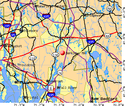
- OSM Map
- General Map
- Google Map
- MSN Map
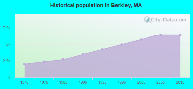
Population change since 2000: +11.5%
 |
| Males: 3,162 | |
| Females: 3,249 |
| Median resident age: | 40.1 years |
| Massachusetts median age: | 39.2 years |
Zip codes: 02779.
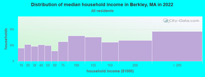
| Berkley: | $124,297 |
| MA: | $94,488 |
Estimated per capita income in 2022: $44,150 (it was $21,652 in 2000)
Berkley town income, earnings, and wages data
Estimated median house or condo value in 2022: $490,736 (it was $167,100 in 2000)
| Berkley: | $490,736 |
| MA: | $534,700 |
Mean prices in 2022: all housing units: $449,660; detached houses: $484,124; townhouses or other attached units: $382,766; in 2-unit structures: $322,469; in 3-to-4-unit structures: $355,875; in 5-or-more-unit structures: $269,714; mobile homes: $156,871; occupied boats, rvs, vans, etc.: $49,834
Detailed information about poverty and poor residents in Berkley, MA
Compare current foreclosures near Berkley, MA:
| Photo | Address | Area | Beds / Baths | Price | Details |
|---|---|---|---|---|---|

|
#1
Padelford St
Berkley, MA 02779
|
1,680 sq. feet
|
1 baths 3 beds |
show details | |

|
#2
Water St
Berkley, MA 02779
|
960 sq. feet
|
1 baths 3 beds |
show details | |

|
#3
Michelle Lee Dr
Berkley, MA 02779
|
1,760 sq. feet
|
2 baths 3 beds |
show details | |

|
#4
Plain St E
Berkley, MA 02779
|
1,056 sq. feet
|
2 baths 3 beds |
show details | |

|
#5
Berkley St
Berkley, MA 02779
|
1,144 sq. feet
|
1 baths 3 beds |
show details | |

|
#6
Water St
Berkley, MA 02779
|
864 sq. feet
|
1 baths 2 beds |
show details | |

|
#7
Holloway St
Berkley, MA 02779
|
1,056 sq. feet
|
1 baths 3 beds |
show details | |

|
#8
Grove St
Berkley, MA 02779
|
- sq. feet
|
- baths - beds |
show details | |

|
#9
Loomis St
North Attleboro, MA 02760
|
2,294 sq. feet
|
2 baths 4 beds |
$700,000
|
show details |

|
#10
Eugenia St
New Bedford, MA 02745
|
2,360 sq. feet
|
2 baths 6 beds |
show details |
| Photo | Address | Area | Beds / Baths | Price | Details |
|---|---|---|---|---|---|

|
#11
Bliss St
Fall River, MA 02720
|
1,220 sq. feet
|
2 baths 2 beds |
show details | |

|
#12
Roosevelt Dr
Bristol, RI 02809
|
1,848 sq. feet
|
2 baths 4 beds |
show details | |

|
#13
Pasture Ln
Halifax, MA 02338
|
2,144 sq. feet
|
3 baths 4 beds |
show details | |

|
#14
Donovan Ln
Mansfield, MA 02048
|
2,187 sq. feet
|
3 baths 3 beds |
show details | |

|
#15
Stewart St
Fall River, MA 02720
|
1,575 sq. feet
|
2 baths 6 beds |
show details | |

|
#16
Magoun Ave
Brockton, MA 02301
|
868 sq. feet
|
1 baths 3 beds |
show details | |

|
#17
Washburn St
Brockton, MA 02301
|
1,462 sq. feet
|
1 baths 3 beds |
show details | |

|
#18
Plymouth St
Middleboro, MA 02346
|
1,510 sq. feet
|
2 baths 2 beds |
show details | |

|
#19
Homestead Ave
Acushnet, MA 02743
|
936 sq. feet
|
1 baths 3 beds |
show details | |

|
#20
Powderhorn Dr
Taunton, MA 02780
|
1,588 sq. feet
|
2 baths 3 beds |
show details |
| Photo | Address | Area | Beds / Baths | Price | Details |
|---|---|---|---|---|---|

|
#21
Ivy Ln
Lakeville, MA 02347
|
496 sq. feet
|
1 baths 1 beds |
show details | |

|
#22
Arthur St
Seekonk, MA 02771
|
1,367 sq. feet
|
2 baths 2 beds |
show details | |

|
#23
Chipaway Rd
East Freetown, MA 02717
|
1,040 sq. feet
|
1 baths 2 beds |
show details | |

|
#24
Meadow St
Taunton, MA 02780
|
1,656 sq. feet
|
3 baths 7 beds |
show details | |

|
#25
Walnut St
Halifax, MA 02338
|
2,340 sq. feet
|
3 baths 2 beds |
show details | |

|
#26
Shawmut Ave
New Bedford, MA 02740
|
1,502 sq. feet
|
2 baths 3 beds |
show details | |

|
#27
Tremont St
Taunton, MA 02780
|
1,430 sq. feet
|
2 baths 3 beds |
show details | |

|
#28
Bedford St
New Bedford, MA 02740
|
1,658 sq. feet
|
2 baths 3 beds |
show details | |

|
#29
Rome Blvd
Attleboro, MA 02703
|
1,791 sq. feet
|
3 baths 4 beds |
show details | |

|
#30
Locust St
New Bedford, MA 02740
|
759 sq. feet
|
1 baths 2 beds |
show details |
| Photo | Address | Area | Beds / Baths | Price | Details |
|---|---|---|---|---|---|

|
#31
Hillberg Ave
Brockton, MA 02301
|
1,458 sq. feet
|
1 baths 4 beds |
show details | |

|
#32
Morton St
Fairhaven, MA 02719
|
1,041 sq. feet
|
1 baths 3 beds |
show details | |

|
#33
Middlesex Ave
Norton, MA 02766
|
1,080 sq. feet
|
2 baths 3 beds |
show details | |

|
#34
Pearl St
Middleboro, MA 02346
|
1,992 sq. feet
|
2 baths 3 beds |
show details | |

|
#35
Chesworth St
Fall River, MA 02723
|
1,767 sq. feet
|
2 baths 5 beds |
show details | |

|
#36
Church St Apt 71
New Bedford, MA 02745
|
759 sq. feet
|
1 baths 2 beds |
show details | |

|
#37
Juniper Rd Unit A10
North Attleboro, MA 02760
|
693 sq. feet
|
1 baths 1 beds |
show details | |

|
#38
Duncan St
Fall River, MA 02721
|
1,326 sq. feet
|
2 baths 3 beds |
show details | |

|
#39
Juniper Rd # C9
North Attleboro, MA 02760
|
697 sq. feet
|
1 baths 1 beds |
show details | |

|
#40
Pine Tree Dr
Middleboro, MA 02346
|
1,456 sq. feet
|
1 baths 5 beds |
show details |
| Photo | Address | Area | Beds / Baths | Price | Details |
|---|---|---|---|---|---|

|
#41
Phillips Rd
New Bedford, MA 02745
|
1,188 sq. feet
|
2 baths 3 beds |
show details | |

|
#42
Mayo Dr
Warren, RI 02885
|
1,739 sq. feet
|
1 baths 3 beds |
show details | |

|
#43
Wareham St
Middleboro, MA 02346
|
912 sq. feet
|
1 baths 2 beds |
show details | |

|
#44
Cappys Way
Brockton, MA 02302
|
2,128 sq. feet
|
2 baths 4 beds |
show details | |

|
#45
Pokross St
Fall River, MA 02724
|
960 sq. feet
|
1 baths 3 beds |
show details | |

|
#46
Hidden Hills Dr
Seekonk, MA 02771
|
2,176 sq. feet
|
3 baths 3 beds |
show details | |

|
#47
Rice St
Middleboro, MA 02346
|
2,326 sq. feet
|
2 baths 4 beds |
show details | |

|
#48
Darby Rd
Brockton, MA 02302
|
1,436 sq. feet
|
2 baths 3 beds |
show details | |

|
#49
Hemlock St
South Dartmouth, MA 02748
|
2,822 sq. feet
|
3 baths 5 beds |
show details | |

|
Check over 1 million property listings on Foreclosure.com!
|
browse all offers | |||

- 6,12595.5%White alone
- 901.4%Hispanic
- 701.1%Two or more races
- 550.9%Black alone
- 370.6%Other race alone
- 270.4%Asian alone
- 60.09%American Indian alone
- 10.02%Native Hawaiian and Other
Pacific Islander alone
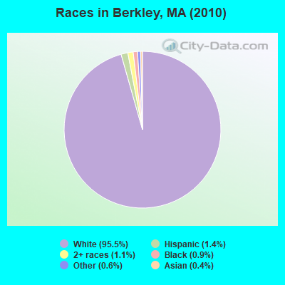
Races in Berkley detailed stats: ancestries, foreign born residents, place of birth
According to our research of Massachusetts and other state lists, there was 1 registered sex offender living in Berkley, Massachusetts as of July 03, 2024.
The ratio of all residents to sex offenders in Berkley is 6,411 to 1.
The ratio of registered sex offenders to all residents in this city is much lower than the state average.
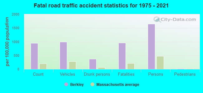
Type |
2009 |
2010 |
2011 |
2012 |
2013 |
2014 |
2015 |
2016 |
2017 |
2018 |
2019 |
2020 |
2021 |
2022 |
|---|---|---|---|---|---|---|---|---|---|---|---|---|---|---|
| Murders (per 100,000) | 0 (0.0) | 0 (0.0) | 0 (0.0) | 0 (0.0) | 0 (0.0) | 0 (0.0) | 0 (0.0) | 0 (0.0) | 0 (0.0) | 0 (0.0) | 0 (0.0) | 0 (0.0) | 0 (0.0) | 0 (0.0) |
| Rapes (per 100,000) | 1 (15.1) | 0 (0.0) | 0 (0.0) | 2 (30.9) | 0 (0.0) | 1 (15.2) | 2 (30.2) | 0 (0.0) | 5 (74.1) | 0 (0.0) | 2 (29.4) | 0 (0.0) | 1 (14.3) | 1 (14.6) |
| Robberies (per 100,000) | 0 (0.0) | 1 (15.6) | 1 (15.5) | 0 (0.0) | 1 (15.3) | 1 (15.2) | 0 (0.0) | 0 (0.0) | 2 (29.7) | 0 (0.0) | 0 (0.0) | 0 (0.0) | 0 (0.0) | 0 (0.0) |
| Assaults (per 100,000) | 20 (303.0) | 5 (78.0) | 3 (46.5) | 5 (77.2) | 8 (122.3) | 3 (45.7) | 6 (90.6) | 7 (104.8) | 5 (74.1) | 7 (103.7) | 6 (88.2) | 6 (87.4) | 3 (42.8) | 3 (43.8) |
| Burglaries (per 100,000) | 41 (621.1) | 36 (561.5) | 48 (744.2) | 36 (556.0) | 21 (321.0) | 11 (167.7) | 8 (120.8) | 13 (194.7) | 9 (133.4) | 6 (88.9) | 9 (132.4) | 5 (72.8) | 3 (42.8) | 0 (0.0) |
| Thefts (per 100,000) | 33 (499.9) | 44 (686.3) | 55 (852.7) | 36 (556.0) | 23 (351.5) | 25 (381.2) | 18 (271.8) | 15 (224.6) | 26 (385.5) | 9 (133.4) | 9 (132.4) | 5 (72.8) | 7 (99.9) | 7 (102.3) |
| Auto thefts (per 100,000) | 8 (121.2) | 3 (46.8) | 5 (77.5) | 3 (46.3) | 1 (15.3) | 4 (61.0) | 0 (0.0) | 5 (74.9) | 5 (74.1) | 4 (59.3) | 1 (14.7) | 2 (29.1) | 1 (14.3) | 4 (58.4) |
| Arson (per 100,000) | 1 (15.1) | 1 (15.6) | 2 (31.0) | 0 (0.0) | 0 (0.0) | 0 (0.0) | 0 (0.0) | 0 (0.0) | 0 (0.0) | 0 (0.0) | 0 (0.0) | 0 (0.0) | 0 (0.0) | 0 (0.0) |
| City-Data.com crime index | 145.9 | 90.8 | 106.4 | 105.0 | 66.8 | 57.8 | 61.6 | 49.6 | 113.7 | 37.0 | 56.9 | 27.8 | 28.1 | 29.2 |
The City-Data.com crime index weighs serious crimes and violent crimes more heavily. Higher means more crime, U.S. average is 246.1. It adjusts for the number of visitors and daily workers commuting into cities.
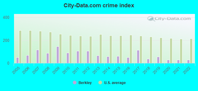
Crime rate in Berkley detailed stats: murders, rapes, robberies, assaults, burglaries, thefts, arson
Full-time law enforcement employees in 2021, including police officers: 9 (9 officers - 8 male; 1 female).
| Officers per 1,000 residents here: | 1.28 |
| Massachusetts average: | 2.53 |
 Recent articles from our blog. Our writers, many of them Ph.D. graduates or candidates, create easy-to-read articles on a wide variety of topics.

 | 2023 Real Estate Observations (5278 replies) |
| Where do you live in Boston and how arevyou approached by homeless people? (70 replies) |
| And then there were two... (758 replies) |
| Norwell, MA convenience store robbed (8 replies) |
| Acceptance rates: BC 27%, Wellesley 22%, BU 19%, Northeastern 18%, Tufts 15%, (93 replies) |
| South Coast Rail to New Bedford & Fall River... (20 replies) |
Latest news from Berkley, MA collected exclusively by city-data.com from local newspapers, TV, and radio stations
Ancestries: Portuguese (21.4%), Irish (20.7%), English (17.6%), French (12.3%), Italian (9.8%), French Canadian (8.0%).
Current Local Time: EST time zone
Incorporated in 1735
Elevation: 80 feet
Land area: 16.5 square miles.
Population density: 388 people per square mile (very low).
164 residents are foreign born (2.4% Europe).
| This town: | 2.9% |
| Massachusetts: | 12.2% |
| Berkley town: | 1.0% ($1,733) |
| Massachusetts: | 1.3% ($2,336) |
Nearest city with pop. 50,000+: Taunton, MA  (5.3 miles , pop. 55,976).
Nearest city with pop. 200,000+: Boston, MA (34.3 miles , pop. 589,141).
Nearest city with pop. 1,000,000+: Bronx, NY (160.2 miles , pop. 1,332,650).
Nearest cities:
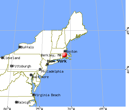
), )Latitude: 41.83 N, Longitude: 71.08 W

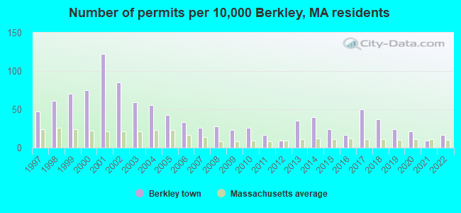
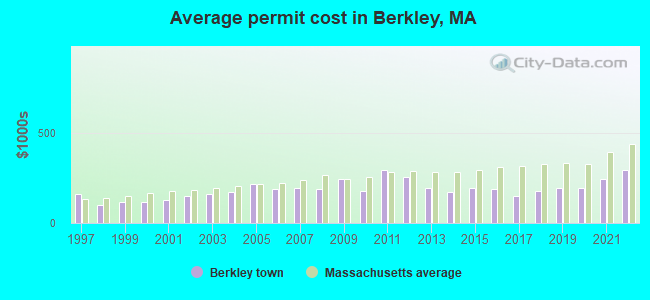
Single-family new house construction building permits:
- 2022: 10 buildings, average cost: $290,900
- 2021: 5 buildings, average cost: $244,600
- 2020: 12 buildings, average cost: $191,100
- 2019: 14 buildings, average cost: $194,200
- 2018: 21 buildings, average cost: $174,700
- 2017: 29 buildings, average cost: $150,200
- 2016: 10 buildings, average cost: $186,000
- 2015: 14 buildings, average cost: $195,600
- 2014: 23 buildings, average cost: $174,000
- 2013: 20 buildings, average cost: $191,600
- 2012: 5 buildings, average cost: $256,400
- 2011: 10 buildings, average cost: $290,500
- 2010: 15 buildings, average cost: $177,500
- 2009: 13 buildings, average cost: $244,900
- 2008: 16 buildings, average cost: $188,200
- 2007: 15 buildings, average cost: $196,400
- 2006: 19 buildings, average cost: $187,700
- 2005: 25 buildings, average cost: $215,600
- 2004: 32 buildings, average cost: $168,700
- 2003: 34 buildings, average cost: $160,800
- 2002: 49 buildings, average cost: $150,200
- 2001: 70 buildings, average cost: $128,500
- 2000: 43 buildings, average cost: $115,400
- 1999: 40 buildings, average cost: $114,400
- 1998: 35 buildings, average cost: $101,400
- 1997: 27 buildings, average cost: $159,600
| Here: | 3.8% |
| Massachusetts: | 3.5% |
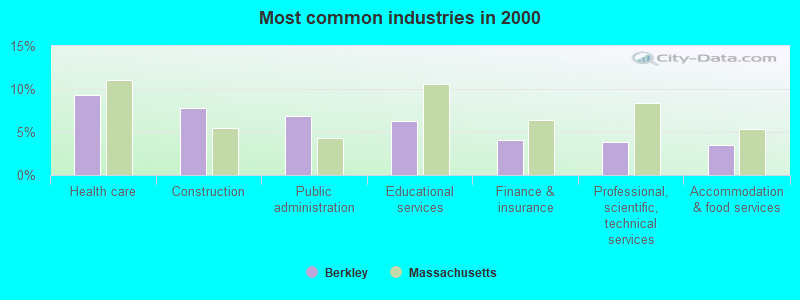
- Health care (9.3%)
- Construction (7.8%)
- Public administration (6.8%)
- Educational services (6.3%)
- Finance & insurance (4.0%)
- Professional, scientific, technical services (3.8%)
- Accommodation & food services (3.5%)
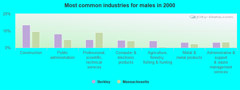
- Construction (13.5%)
- Public administration (8.1%)
- Professional, scientific, technical services (4.8%)
- Computer & electronic products (4.4%)
- Agriculture, forestry, fishing & hunting (4.1%)
- Metal & metal products (3.2%)
- Administrative & support & waste management services (3.2%)
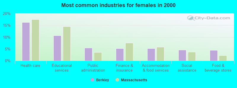
- Health care (16.3%)
- Educational services (10.7%)
- Public administration (5.4%)
- Finance & insurance (5.2%)
- Accommodation & food services (5.2%)
- Social assistance (4.6%)
- Food & beverage stores (4.4%)
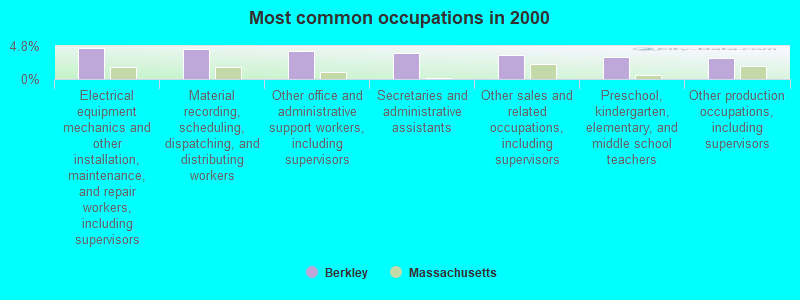
- Electrical equipment mechanics and other installation, maintenance, and repair workers, including supervisors (4.4%)
- Material recording, scheduling, dispatching, and distributing workers (4.4%)
- Other office and administrative support workers, including supervisors (4.1%)
- Secretaries and administrative assistants (3.8%)
- Other sales and related occupations, including supervisors (3.5%)
- Preschool, kindergarten, elementary, and middle school teachers (3.3%)
- Other production occupations, including supervisors (3.1%)
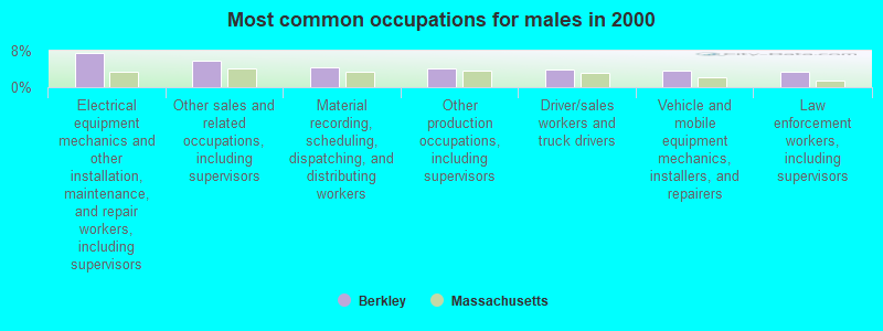
- Electrical equipment mechanics and other installation, maintenance, and repair workers, including supervisors (7.6%)
- Other sales and related occupations, including supervisors (5.9%)
- Material recording, scheduling, dispatching, and distributing workers (4.3%)
- Other production occupations, including supervisors (4.1%)
- Driver/sales workers and truck drivers (3.8%)
- Vehicle and mobile equipment mechanics, installers, and repairers (3.7%)
- Law enforcement workers, including supervisors (3.4%)

- Secretaries and administrative assistants (8.0%)
- Other office and administrative support workers, including supervisors (6.0%)
- Health technologists and technicians (5.4%)
- Registered nurses (5.2%)
- Waiters and waitresses (4.8%)
- Preschool, kindergarten, elementary, and middle school teachers (4.6%)
- Material recording, scheduling, dispatching, and distributing workers (4.4%)
Average climate in Berkley, Massachusetts
Based on data reported by over 4,000 weather stations


(lower is better)
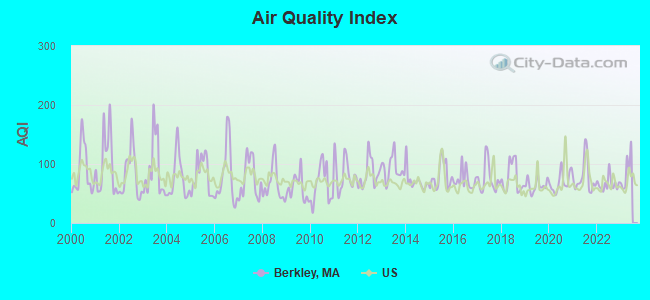
Air Quality Index (AQI) level in 2022 was 65.8. This is about average.
| City: | 65.8 |
| U.S.: | 72.6 |
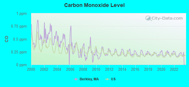
Carbon Monoxide (CO) [ppm] level in 2022 was 0.196. This is better than average. Closest monitor was 14.6 miles away from the city center.
| City: | 0.196 |
| U.S.: | 0.251 |
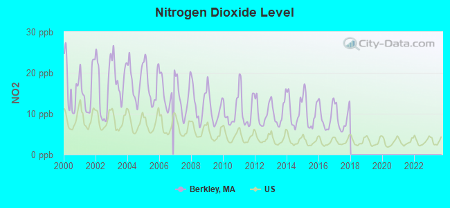
Nitrogen Dioxide (NO2) [ppb] level in 2017 was 8.78. This is significantly worse than average. Closest monitor was 5.6 miles away from the city center.
| City: | 8.78 |
| U.S.: | 5.11 |
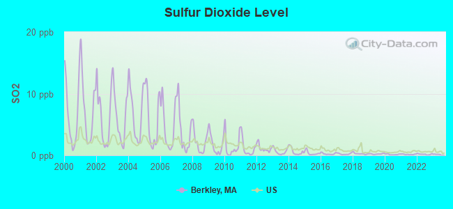
Sulfur Dioxide (SO2) [ppb] level in 2022 was 0.179. This is significantly better than average. Closest monitor was 5.6 miles away from the city center.
| City: | 0.179 |
| U.S.: | 1.515 |
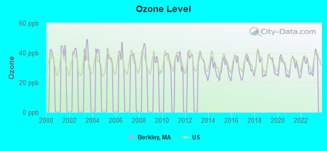
Ozone [ppb] level in 2022 was 31.0. This is about average. Closest monitor was 10.7 miles away from the city center.
| City: | 31.0 |
| U.S.: | 33.3 |
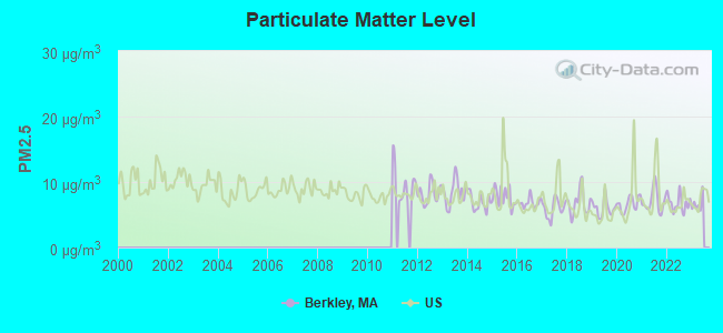
Particulate Matter (PM2.5) [µg/m3] level in 2022 was 6.76. This is better than average. Closest monitor was 10.7 miles away from the city center.
| City: | 6.76 |
| U.S.: | 8.11 |
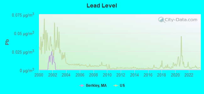
Lead (Pb) [µg/m3] level in 2001 was 0.0153. This is significantly worse than average. Closest monitor was 9.2 miles away from the city center.
| City: | 0.0153 |
| U.S.: | 0.0093 |
Tornado activity:
Berkley-area historical tornado activity is below Massachusetts state average. It is 60% smaller than the overall U.S. average.
On 6/9/1953, a category F3 (max. wind speeds 158-206 mph) tornado 16.8 miles away from the Berkley town center injured 17 people and caused between $500,000 and $5,000,000 in damages.
On 6/9/1953, a category F4 (max. wind speeds 207-260 mph) tornado 39.9 miles away from the town center killed 90 people and injured 1228 people and caused between $50,000,000 and $500,000,000 in damages.
Earthquake activity:
Berkley-area historical earthquake activity is significantly above Massachusetts state average. It is 74% smaller than the overall U.S. average.On 10/7/1983 at 10:18:46, a magnitude 5.3 (5.1 MB, 5.3 LG, 5.1 ML, Class: Moderate, Intensity: VI - VII) earthquake occurred 221.4 miles away from Berkley center
On 4/20/2002 at 10:50:47, a magnitude 5.3 (5.3 ML, Depth: 3.0 mi) earthquake occurred 228.0 miles away from the city center
On 1/19/1982 at 00:14:42, a magnitude 4.7 (4.5 MB, 4.7 MD, 4.5 LG, Class: Light, Intensity: IV - V) earthquake occurred 118.8 miles away from the city center
On 10/16/2012 at 23:12:25, a magnitude 4.7 (4.7 ML, Depth: 10.0 mi) earthquake occurred 124.4 miles away from the city center
On 4/20/2002 at 10:50:47, a magnitude 5.2 (5.2 MB, 4.2 MS, 5.2 MW, 5.0 MW) earthquake occurred 227.2 miles away from Berkley center
On 8/22/1992 at 12:20:32, a magnitude 4.8 (4.8 MB, 3.8 MS, 4.7 LG, Depth: 6.2 mi) earthquake occurred 192.3 miles away from the city center
Magnitude types: regional Lg-wave magnitude (LG), body-wave magnitude (MB), duration magnitude (MD), local magnitude (ML), surface-wave magnitude (MS), moment magnitude (MW)
Natural disasters:
The number of natural disasters in Bristol County (23) is greater than the US average (15).Major Disasters (Presidential) Declared: 12
Emergencies Declared: 11
Causes of natural disasters: Floods: 8, Hurricanes: 7, Storms: 5, Snows: 3, Snowstorms: 3, Winter Storms: 3, Blizzards: 2, Explosion: 1, Heavy Rain: 1, Snowfall: 1, Tropical Storm: 1, Wind: 1 (Note: some incidents may be assigned to more than one category).
Hospitals and medical centers near Berkley:
- MARIAN MANOR OF TAUNTON (Nursing Home, about 6 miles away; TAUNTON, MA)
- SARAH BRAYTON NURSING CARE CTR (Nursing Home, about 6 miles away; FALL RIVER, MA)
- LONGMEADOW NURSING HOME (Nursing Home, about 6 miles away; TAUNTON, MA)
- LIFE CARE CENTER OF RAYNHAM (Nursing Home, about 6 miles away; RAYNHAM, MA)
- MORTON HOSPITAL Acute Care Hospitals (about 6 miles away; TAUNTON, MA)
- GOLDEN LIVING CENTER-WEDGEMERE (Nursing Home, about 6 miles away; TAUNTON, MA)
- WEDGEMERE CONV HOME (Nursing Home, about 6 miles away; TAUNTON, MA)
Airports and other landing facilities located in Berkley:
- Myricks Airport (1M8) (Runways: 1, Itinerant Ops: 400, Local Ops: 2,200, Military Ops: 5)
- Wamsetto Seaplane Base (27MA)
Amtrak station near Berkley:
Colleges/universities with over 2000 students nearest to Berkley:
- Bristol Community College (about 8 miles; Fall River, MA; Full-time enrollment: 5,707)
- Bridgewater State University (about 13 miles; Bridgewater, MA; FT enrollment: 9,802)
- University of Massachusetts-Dartmouth (about 15 miles; North Dartmouth, MA; FT enrollment: 7,545)
- Roger Williams University (about 16 miles; Bristol, RI; FT enrollment: 4,375)
- Stonehill College (about 17 miles; Easton, MA; FT enrollment: 2,563)
- Brown University (about 17 miles; Providence, RI; FT enrollment: 8,458)
- Rhode Island School of Design (about 17 miles; Providence, RI; FT enrollment: 2,714)
Public elementary/middle schools in Berkley:
- BERKLEY COMMUNITY SCHOOL (Students: 586, Location: 59 SOUTH MAIN STREET, Grades: PK-4)
- BERKLEY MIDDLE SCHOOL (Students: 404, Location: 21 NORTH MAIN STREET, Grades: 5-8)
Points of interest:
Notable locations in Berkley: Camp Merriwood (A), Berkley Fire Department Station 2 (B), Berkley Fire and Rescue Station 1 Headquarters (C). Display/hide their locations on the map
Cemetery: Fox Cemetery (1). Display/hide its location on the map
Rivers: Assonet River (A), Threemile River (B). Display/hide their locations on the map
Park in Berkley: Dighton Rock State Park (1). Display/hide its location on the map
| This town: | 3.0 people |
| Massachusetts: | 2.5 people |
| This town: | 82.8% |
| Whole state: | 63.0% |
| This town: | 6.5% |
| Whole state: | 7.0% |
Likely homosexual households (counted as self-reported same-sex unmarried-partner households)
- Lesbian couples: 0.4% of all households
- Gay men: 0.2% of all households
| This town: | 2.5% |
| Whole state: | 9.3% |
| This town: | 1.5% |
| Whole state: | 4.4% |
7 people in group homes intended for adults in 2010
12 people in homes for the mentally ill in 2000
3 people in homes for the mentally retarded in 2000
For population 15 years and over in Berkley:
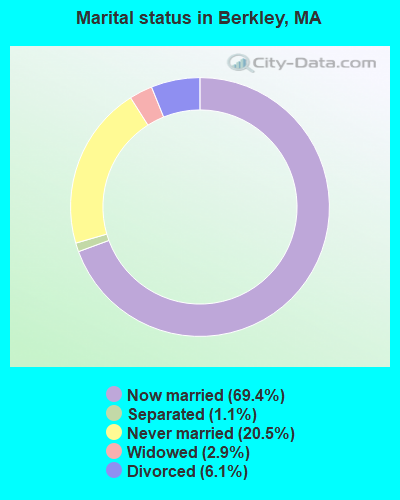
- Never married: 20.5%
- Now married: 69.4%
- Separated: 1.1%
- Widowed: 2.9%
- Divorced: 6.1%
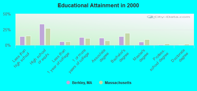
For population 25 years and over in Berkley:
- High school or higher: 85.7%
- Bachelor's degree or higher: 20.8%
- Graduate or professional degree: 6.6%
- Unemployed: 1.9%
- Mean travel time to work (commute): 32.0 minutes
| Here: | 10.5 |
| Massachusetts average: | 13.1 |
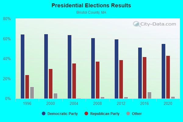
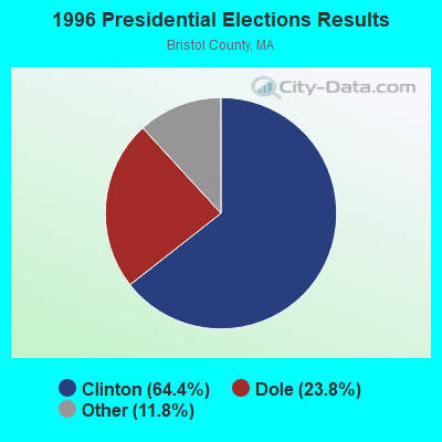
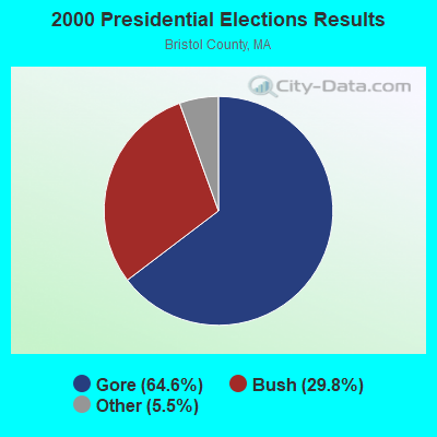
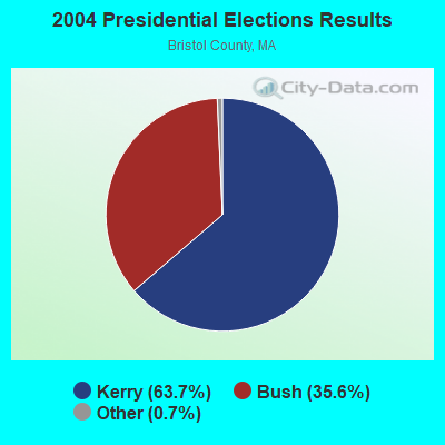
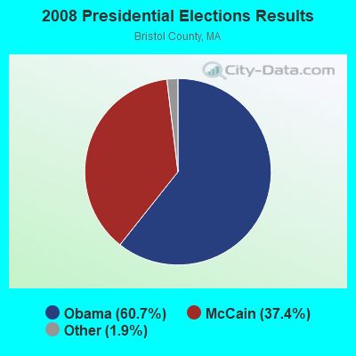
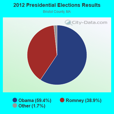

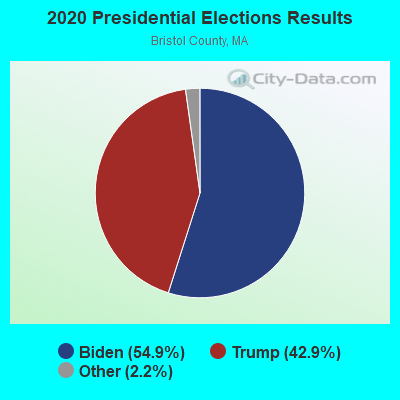
Graphs represent county-level data. Detailed 2008 Election Results
Religion statistics for Berkley, MA (based on Bristol County data)
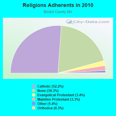
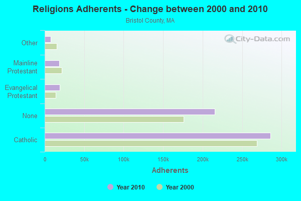
| Religion | Adherents | Congregations |
|---|---|---|
| Catholic | 286,113 | 72 |
| Evangelical Protestant | 18,765 | 128 |
| Mainline Protestant | 18,246 | 83 |
| Other | 7,807 | 33 |
| Orthodox | 1,565 | 4 |
| Black Protestant | 511 | 5 |
| None | 215,278 | - |
Food Environment Statistics:
| Bristol County: | 2.00 / 10,000 pop. |
| State: | 1.98 / 10,000 pop. |
| Bristol County: | 0.09 / 10,000 pop. |
| Massachusetts: | 0.05 / 10,000 pop. |
| This county: | 1.93 / 10,000 pop. |
| Massachusetts: | 2.22 / 10,000 pop. |
| Bristol County: | 2.35 / 10,000 pop. |
| State: | 1.77 / 10,000 pop. |
| Bristol County: | 8.20 / 10,000 pop. |
| Massachusetts: | 8.76 / 10,000 pop. |
| Bristol County: | 9.5% |
| Massachusetts: | 8.1% |
| Bristol County: | 26.9% |
| Massachusetts: | 22.5% |
| Bristol County: | 14.4% |
| State: | 16.5% |
4.76% of this county's 2021 resident taxpayers lived in other counties in 2020 ($70,162 average adjusted gross income)
| Here: | 4.76% |
| Massachusetts average: | 6.35% |
0.01% of residents moved from foreign countries ($64 average AGI)
Bristol County: 0.01% Massachusetts average: 0.01%
Top counties from which taxpayers relocated into this county between 2020 and 2021:
| from Plymouth County, MA | |
| from Norfolk County, MA | |
| from Providence County, RI |
4.63% of this county's 2020 resident taxpayers moved to other counties in 2021 ($72,404 average adjusted gross income)
| Here: | 4.63% |
| Massachusetts average: | 7.18% |
0.01% of residents moved to foreign countries ($83 average AGI)
Bristol County: 0.01% Massachusetts average: 0.02%
Top counties to which taxpayers relocated from this county between 2020 and 2021:
| to Plymouth County, MA | |
| to Providence County, RI | |
| to Norfolk County, MA |
Businesses in Berkley, MA
- Dunkin Donuts: 1
Strongest AM radio stations in Berkley:
- WALE (990 AM; 50 kW; GREENVILLE, RI; Owner: NORTH AMERICAN BROADCASTING CO., INC.)
- WEEI (850 AM; 50 kW; BOSTON, MA; Owner: ENTERCOM BOSTON LICENSE, LLC)
- WBZ (1030 AM; 50 kW; BOSTON, MA; Owner: INFINITY BROADCASTING OPERATIONS, INC.)
- WPRO (630 AM; 5 kW; PROVIDENCE, RI; Owner: CITADEL BROADCASTING COMPANY)
- WSAR (1480 AM; 5 kW; FALL RIVER, MA; Owner: BRISTOL COUNTY BROADCASTING, INC.)
- WPEP (1570 AM; 1 kW; TAUNTON, MA; Owner: ANASTOS MEDIA GROUP, INC.)
- WRKO (680 AM; 50 kW; BOSTON, MA; Owner: ENTERCOM BOSTON LICENSE, LLC)
- WKOX (1200 AM; 50 kW; FRAMINGHAM, MA; Owner: CAPSTAR TX LIMITED PARTNERSHIP)
- WHJJ (920 AM; 5 kW; PROVIDENCE, RI)
- WSKO (790 AM; 5 kW; PROVIDENCE, RI; Owner: CITADEL BROADCASTING COMPANY)
- WBIX (1060 AM; 40 kW; NATICK, MA; Owner: LANGER BROADCASTING CORPORATION)
- WDDZ (550 AM; 5 kW; PAWTUCKET, RI; Owner: ABC, INC.)
- WAMG (890 AM; 25 kW; DEDHAM, MA; Owner: MEGA COMMUNICATIONS OF DEDHAM LICENSEE, LLC)
Strongest FM radio stations in Berkley:
- WWBB (101.5 FM; PROVIDENCE, RI; Owner: CLEAR CHANNEL BROADCASTING LICENSES, INC.)
- WSNE-FM (93.3 FM; TAUNTON, MA; Owner: CAPSTAR TX LIMITED PARTNERSHIP)
- WBRU (95.5 FM; PROVIDENCE, RI; Owner: BROWN BROADCASTING SERVICE, INC.)
- WBOT (97.7 FM; BROCKTON, MA; Owner: RADIO ONE LICENSES, LLC)
- WCTK (98.1 FM; NEW BEDFORD, MA; Owner: HALL COMMUNICATIONS, INC.)
- WHJY (94.1 FM; PROVIDENCE, RI; Owner: CAPSTAR TX LIMITED PARTNERSHIP)
- WJFD-FM (97.3 FM; NEW BEDFORD, MA; Owner: EDMUND DINIS, TRUSTEE)
- WKKB (100.3 FM; MIDDLETOWN, RI; Owner: CITADEL BROADCASTING COMPANY)
- WBMX (98.5 FM; BOSTON, MA; Owner: INFINITY RADIO OPERATIONS INC.)
- WBOS (92.9 FM; BROOKLINE, MA; Owner: GREATER BOSTON RADIO, INC.)
- WJMN (94.5 FM; BOSTON, MA; Owner: AMFM RADIO LICENSES, L.L.C.)
- WCRB (102.5 FM; WALTHAM, MA; Owner: CHARLES RIVER BROADCASTING WCRB LICE)
- WTKK (96.9 FM; BOSTON, MA; Owner: GREATER BOSTON RADIO, INC.)
- WROR-FM (105.7 FM; FRAMINGHAM, MA; Owner: GREATER BOSTON RADIO, INC.)
- WXKS-FM (107.9 FM; MEDFORD, MA; Owner: AMFM RADIO LICENSES, L.L.C.)
- WPRO-FM (92.3 FM; PROVIDENCE, RI; Owner: CITADEL BROADCASTING COMPANY)
- WMJX (106.7 FM; BOSTON, MA; Owner: GREATER BOSTON RADIO, INC.)
- WGBH (89.7 FM; BOSTON, MA; Owner: WGBH EDUCATIONAL FOUNDATION)
- WFHN (107.1 FM; FAIRHAVEN, MA; Owner: CITADEL BROADCASTING COMPANY)
- WWLI (105.1 FM; PROVIDENCE, RI; Owner: CITADEL BROADCASTING COMPANY)
TV broadcast stations around Berkley:
- WLNE-TV (Channel 6; NEW BEDFORD, MA; Owner: FREEDOM BROADCASTING OF SOUTHERN NEW ENGLAND, INC.)
- WLWC (Channel 28; NEW BEDFORD, MA; Owner: C-28 FCC LICENSEE SUBSIDIARY, LLC)
- WPRI-TV (Channel 12; PROVIDENCE, RI; Owner: TVL BROADCASTING OF RHODE ISLAND, LLC)
- WNAC-TV (Channel 64; PROVIDENCE, RI; Owner: WNAC, LLC)
- WJAR (Channel 10; PROVIDENCE, RI; Owner: OUTLET BROADCASTING, INC.)
- WSBE-TV (Channel 36; PROVIDENCE, RI; Owner: RHODE ISLAND PUBLIC TELECOM. AUTHORITY)
- WWDP (Channel 46; NORWELL, MA; Owner: NORWELL TELEVISION, LLC)
- WCVB-TV (Channel 5; BOSTON, MA; Owner: WCVB HEARST-ARGYLE TV, INC.)
- WGBH-TV (Channel 2; BOSTON, MA; Owner: WGBH EDUCATIONAL FOUNDATION)
- WHDH-TV (Channel 7; BOSTON, MA; Owner: WHDH-TV)
- WMFP (Channel 62; LAWRENCE, MA; Owner: WSAH LICENSE, INC.)
- WSBK-TV (Channel 38; BOSTON, MA; Owner: VIACOM INC.)
- WLVI-TV (Channel 56; CAMBRIDGE, MA; Owner: WLVI, INC.)
- WPXQ (Channel 69; BLOCK ISLAND, RI; Owner: OCEAN STATE TELEVISION, L.L.C.)
- WBZ-TV (Channel 4; BOSTON, MA; Owner: VIACOM INC.)
- WGBX-TV (Channel 44; BOSTON, MA; Owner: WGBH EDUCATIONAL FOUNDATION)
- WFXT (Channel 25; BOSTON, MA; Owner: FOX TELEVISION STATIONS INC.)
- WBPX (Channel 68; BOSTON, MA; Owner: PAXSON BOSTON-68 LICENSE, INC.)
- WUTF (Channel 66; MARLBOROUGH, MA; Owner: TELEFUTURA BOSTON LLC)
- W40BO (Channel 40; BOSTON, MA; Owner: PAXSON COMMUNICATIONS LPTV, INC.)
- WUNI (Channel 27; WORCESTER, MA; Owner: ENTRAVISION HOLDINGS, LLC)
- WTMU-LP (Channel 32; BOSTON, MA; Owner: ZGS BOSTON, INC.)
- WCEA-LP (Channel 58; BOSTON, MA; Owner: CHANNEL 19 TV CORPORATION)
- WRIW-LP (Channel 50; PROVIDENCE, RI; Owner: ZGS PROVIDENCE, INC.)
- National Bridge Inventory (NBI) Statistics
- 3Number of bridges
- 75ft / 23.2mTotal length
- $3,721,000Total costs
- 18,807Total average daily traffic
- 1,020Total average daily truck traffic
FCC Registered Antenna Towers:
43 (See the full list of FCC Registered Antenna Towers in Berkley)FCC Registered Private Land Mobile Towers:
1- Bryant Ave. (Lat: 41.831500 Lon: -71.080056), Type: Tower, Structure height: 40 m, Call Sign: WPLA716,
Assigned Frequencies: 862.037 MHz, 862.062 MHz, 862.087 MHz, 862.112 MHz, 862.137 MHz, 862.162 MHz, 862.187 MHz, 862.212 MHz, 862.237 MHz, 862.262 MHz... (+149 more), Grant Date: 02/28/2012, Expiration Date: 02/06/2022, Cancellation Date: 09/12/2019, Registrant: Sprint Corporation, 12502 Sunrise Valley Drive, M/S: Varesa-0209, Reston, VA 20196, Phone: (800) 572-8256, Fax: (703) 433-4483, Email:
FCC Registered Broadcast Land Mobile Towers:
4- WEST, 61 Bryant Street (Lat: 41.827500 Lon: -71.074722), Type: Ltower, Structure height: 57.9 m, Overall height: 60.7 m, Call Sign: WNNT775,
Assigned Frequencies: 460.625 MHz, 460.625 MHz, Grant Date: 12/29/2023, Expiration Date: 03/03/2034, Registrant: 25 Bullock Rd, East Freetown, MA 02717, Phone: (508) 542-9441, Email:
- 1 N Main St (Lat: 41.846389 Lon: -71.084167), Type: Pole, Structure height: 9.1 m, Overall height: 12.1 m, Call Sign: KNFN756,
Assigned Frequencies: 151.130 MHz, Grant Date: 07/27/2022, Expiration Date: 08/21/2032, Registrant: Monte Dawson, 57 Slab Bridge Roaad, Assonet, MA 02702, Phone: (508) 644-5467, Fax: (508) 644-5497, Email:
- WEST, 61 Bryant Street (Lat: 41.827500 Lon: -71.074722), Type: Ltower, Structure height: 57.9 m, Overall height: 60.7 m, Call Sign: WPWU761,
Assigned Frequencies: 472.100 MHz, 472.712 MHz, 470.925 MHz, Grant Date: 10/26/2022, Expiration Date: 01/23/2033, Certifier: Carlton E Abbott Jr, Registrant: Freetown Police Department, 15 Memorial Drive, East Freetown, MA 02171, Phone: (508) 763-4017, Fax: (508) 763-4010, Email:
- Lat: 41.846111 Lon: -71.082778, Call Sign: WQIG789,
Assigned Frequencies: 72.6000 MHz, Grant Date: 12/05/2017, Expiration Date: 02/05/2028, Certifier: John P Franco, Registrant: Signal Communications Corp, 4 Wheeling Ave, Woburn, MA 01801, Phone: (781) 933-0998, Fax: (781) 933-5019, Email:
FCC Registered Microwave Towers:
7- BERKLEY, 61 Bryant St (Lat: 41.827500 Lon: -71.074722), Type: Mast, Structure height: 55.5 m, Call Sign: WLN547,
Assigned Frequencies: 6775.00 MHz, Grant Date: 01/11/2011, Expiration Date: 02/01/2021, Cancellation Date: 05/05/2017, Certifier: Carol L Tacker, Registrant: At&t Mobility LLC, 1120 20th Street, Nw - Suite 1000, Washington, DC 20036, Phone: (202) 457-2055, Fax: (202) 457-3073, Email:
- BERKLEY, Old Anthony St. (Lat: 41.826278 Lon: -71.042306), Type: Tower, Structure height: 74.3 m, Call Sign: WLW643,
Assigned Frequencies: 10618.7 MHz, Grant Date: 01/11/2011, Expiration Date: 02/01/2021, Cancellation Date: 08/25/2015, Registrant: Verizon Wireless, 1120 Sanctuary Pkwy, #150 Gasa5reg, Alpharetta, GA 30009-7630, Phone: (770) 797-1070, Fax: (770) 797-1036, Email:
- Berkley, Green St And Berkley Rr (088025) (Lat: 41.831306 Lon: -71.079833), Type: Tower, Structure height: 91.4 m, Overall height: 99.7 m, Call Sign: WQBJ200,
Assigned Frequencies: 19400.0 MHz, 6404.79 MHz, Grant Date: 10/18/2004, Expiration Date: 10/18/2014, Cancellation Date: 12/20/2014, Certifier: Alan F Burns, Registrant: Meridian Microwave, 145 Washington Street, Suite 15, Norwell, MA 02061, Phone: (781) 413-5769, Fax: (781) 544-3239, Email:
- J&R PRECASTING MA, 16 County Road (091883) (Lat: 41.845361 Lon: -71.024333), Type: Pole, Structure height: 46.9 m, Overall height: 47.2 m, Call Sign: WQIL312,
Assigned Frequencies: 5945.20 MHz, Grant Date: 03/07/2008, Expiration Date: 03/07/2018, Cancellation Date: 09/07/2009, Certifier: William Chastain, Registrant: Radio Dynamics Corporation, Silver Spring, MD 20914, Phone: (301) 493-5171, Fax: (301) 576-4553, Email:
- ATC, 61 Bryant Street (Lat: 41.827500 Lon: -71.074750), Type: Ltower, Structure height: 54.9 m, Call Sign: WRVS826,
Assigned Frequencies: 10765.0 MHz, Grant Date: 01/03/2023, Expiration Date: 01/03/2033, Certifier: Carlton E Abbott, Jr., Registrant: Langone & Associates, 87 Emerald Court, Tewksbury, MA 01876, Phone: (508) 633-2470, Email:
- BERKLEY, Green St, 1 Mi S Of (Lat: 41.831750 Lon: -71.079750), Overall height: 52.1 m, Call Sign: KVH82,
Assigned Frequencies: 6256.50 MHz, 6256.50 MHz, 6315.90 MHz, 6315.90 MHz, 6375.20 MHz, 6375.20 MHz, Grant Date: 09/19/1985, Expiration Date: 08/05/1996, Cancellation Date: 08/05/1996, Registrant: New England Telephone And Telegraph Company, 125 High St Rm 515, Boston, MA 02110
- BERKLEY, Green St & Berkley Rd (Lat: 41.831750 Lon: -71.079750), Overall height: 99.7 m, Call Sign: KYO24,
Assigned Frequencies: 6197.24 MHz, 6197.24 MHz, 6226.89 MHz, 6226.89 MHz, 6256.54 MHz, 6256.54 MHz, 6286.19 MHz, 6286.19 MHz, 6315.84 MHz, 6315.84 MHz, 6375.14 MHz, 6375.14 MHz, Grant Date: 02/02/2010, Expiration Date: 02/01/2020, Cancellation Date: 07/16/2010, Registrant: At&t Corp., 2315 Salem Road, First Floor, H9, Conyers, GA 30013, Phone: (770) 602-2065, Fax: (770) 929-4454, Email:
FCC Registered Amateur Radio Licenses:
16 (See the full list of FCC Registered Amateur Radio Licenses in Berkley)FAA Registered Aircraft:
10 (See the full list of FAA Registered Aircraft in Berkley)2002 - 2018 National Fire Incident Reporting System (NFIRS) incidents
- Fire incident types reported to NFIRS in Berkley, MA
- 15642.4%Structure Fires
- 12233.2%Outside Fires
- 7720.9%Mobile Property/Vehicle Fires
- 133.5%Other
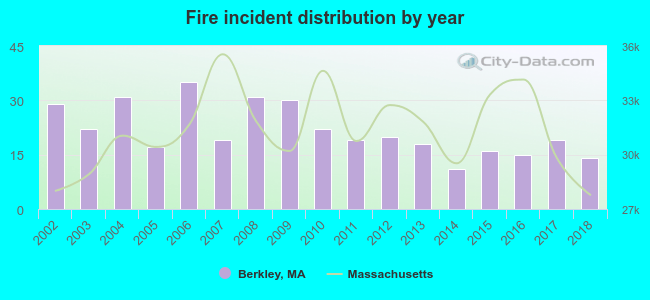 According to the data from the years 2002 - 2018 the average number of fires per year is 22. The highest number of fire incidents - 35 took place in 2006, and the least - 11 in 2014. The data has a declining trend.
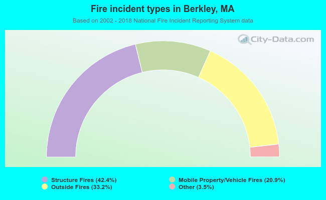 When looking into fire subcategories, the most incidents belonged to: Structure Fires (42.4%), and Outside Fires (33.2%).
Berkley compared to Massachusetts state average:
- Unemployed percentage significantly below state average.
- Black race population percentage significantly below state average.
- Hispanic race population percentage significantly below state average.
- Foreign-born population percentage significantly below state average.
- Renting percentage significantly below state average.
- Length of stay since moving in significantly above state average.
- Number of rooms per house significantly below state average.
- House age significantly below state average.
- Number of college students below state average.
- Percentage of population with a bachelor's degree or higher below state average.
Berkley on our top lists:
- #11 on the list of "Top 101 cities with largest percentage of females in industries: u. s. postal service (population 5,000+)"
- #20 on the list of "Top 101 cities with largest percentage of females in industries: leather and allied products (population 5,000+)"
- #25 on the list of "Top 101 cities with largest percentage of females in occupations: other construction workers and helpers (population 5,000+)"
- #32 on the list of "Top 101 cities with largest percentage of females in occupations: electricians (population 5,000+)"
- #37 on the list of "Top 101 cities with largest percentage of females in occupations: laborers and material movers, hand (population 5,000+)"
- #42 on the list of "Top 101 cities with largest percentage of females in industries: printing and related support activities (population 5,000+)"
- #43 on the list of "Top 101 cities with largest percentage of males in industries: recyclable material merchant wholesalers (population 5,000+)"
- #50 on the list of "Top 101 cities with largest percentage of females in occupations: waiters and waitresses (population 5,000+)"
- #50 on the list of "Top 101 cities with largest percentage of males in industries: electrical and electronic goods merchant wholesalers (population 5,000+)"
- #51 on the list of "Top 101 cities with largest percentage of females in industries: furniture and home furnishings, and household appliance stores (population 5,000+)"
- #57 on the list of "Top 101 cities with largest percentage of females in industries: hardware, plumbing and heating equipment, and supplies merchant wholesalers (population 5,000+)"
- #58 on the list of "Top 101 cities with largest percentage of males in industries: textile mills and textile products (population 5,000+)"
- #59 on the list of "Top 101 cities with largest percentage of males in industries: paper and paper products merchant wholesalers (population 5,000+)"
- #60 on the list of "Top 101 cities with largest percentage of females in occupations: material recording, scheduling, dispatching, and distributing workers (population 5,000+)"
- #63 on the list of "Top 101 cities with largest percentage of males in industries: printing and related support activities (population 5,000+)"
- #67 on the list of "Top 101 cities with largest percentage of males in occupations: drafters, engineering, and mapping technicians (population 5,000+)"
- #68 on the list of "Top 101 cities with largest percentage of males in industries: u. s. postal service (population 5,000+)"
- #72 on the list of "Top 101 cities with largest percentage of males in industries: electronic shopping and mail-order houses (population 5,000+)"
- #92 on the list of "Top 101 cities with the smallest household incomes disparities (population 5,000+)"
- #97 on the list of "Top 101 cities with largest percentage of females in industries: electrical equipment, appliances, and components (population 5,000+)"
- #54 (02779) on the list of "Top 101 zip codes with the largest percentage of Lithuanian first ancestries (pop 5,000+)"
- #100 (02779) on the list of "Top 101 zip codes with the largest percentage of Portuguese first ancestries"
- #14 on the list of "Top 101 counties with the lowest percentage of residents that keep firearms around their homes"
- #29 on the list of "Top 101 counties with the lowest percentage of residents relocating to foreign countries in 2011 (pop. 50,000+)"
- #32 on the list of "Top 101 counties with the most Catholic congregations"
- #34 on the list of "Top 101 counties with the highest percentage of residents that smoked 100+ cigarettes in their lives"
- #41 on the list of "Top 101 counties with the most Catholic adherents"

|
|
Total of 424 patent applications in 2008-2024.