Benton, Maine
Submit your own pictures of this town and show them to the world
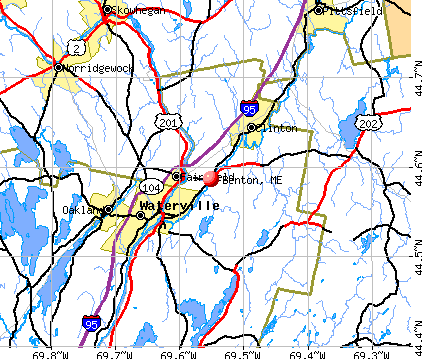
- OSM Map
- General Map
- Google Map
- MSN Map
Population change since 2000: +6.8%
 |
| Males: 1,357 | |
| Females: 1,375 |
| Median resident age: | 42.5 years |
| Maine median age: | 43.0 years |
Zip codes: 04901.
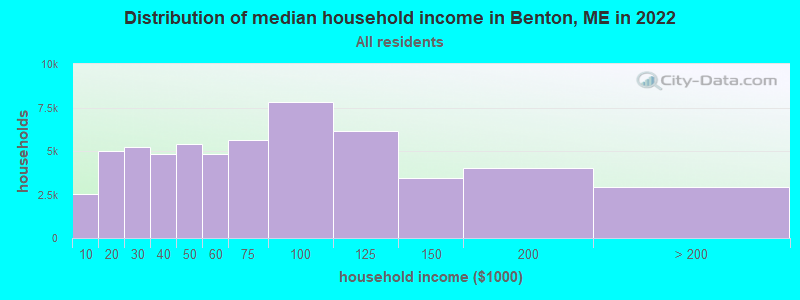
| Benton: | $66,590 |
| ME: | $69,543 |
Estimated per capita income in 2022: $37,073 (it was $18,464 in 2000)
Benton town income, earnings, and wages data
Estimated median house or condo value in 2022: $217,754 (it was $80,100 in 2000)
| Benton: | $217,754 |
| ME: | $290,600 |
Mean prices in 2022: all housing units: $236,573; detached houses: $257,878; townhouses or other attached units: $279,624; in 2-unit structures: $165,218; in 3-to-4-unit structures: $152,679; in 5-or-more-unit structures: $182,239; mobile homes: $91,490
Detailed information about poverty and poor residents in Benton, ME
Compare current foreclosures near Benton, ME:
| Photo | Address | Area | Beds / Baths | Price | Details |
|---|---|---|---|---|---|

|
#1
Kennebec St
Fairfield, ME 04937
|
1,340 sq. feet
|
1 baths 3 beds |
$279,900
|
show details |

|
#2
Hubbard St
Oakland, ME 04963
|
1,126 sq. feet
|
1 baths 1 beds |
$205,000
|
show details |

|
#3
Waterville Rd
South China, ME 04358
|
1,144 sq. feet
|
2 baths 3 beds |
show details | |

|
#4
Ridge Rd
Waterville, ME 04901
|
1,062 sq. feet
|
1 baths 3 beds |
show details | |

|
#5
Smithfield Rd
Oakland, ME 04963
|
860 sq. feet
|
1 baths 2 beds |
show details | |

|
#6
Prospect St
Waterville, ME 04901
|
1,702 sq. feet
|
2 baths 3 beds |
show details | |

|
#7
Cottle Rd
Oakland, ME 04963
|
1,232 sq. feet
|
2 baths 3 beds |
show details | |

|
#8
Belgrade Rd
Oakland, ME 04963
|
1,030 sq. feet
|
1 baths 3 beds |
show details | |

|
#9
Fairwood Dr
Fairfield, ME 04937
|
1,673 sq. feet
|
2 baths 3 beds |
show details | |

|
#10
Carrean St
Waterville, ME 04901
|
1,203 sq. feet
|
1 baths 4 beds |
show details |
| Photo | Address | Area | Beds / Baths | Price | Details |
|---|---|---|---|---|---|

|
#11
Moore St
Waterville, ME 04901
|
1,295 sq. feet
|
1 baths 3 beds |
show details | |

|
#12
Moores Mills Rd
Skowhegan, ME 04976
|
1,296 sq. feet
|
2 baths 3 beds |
show details | |

|
#13
Oak Pond Rd
Skowhegan, ME 04976
|
2,868 sq. feet
|
2 baths 4 beds |
show details | |

|
#14
Church St
Oakland, ME 04963
|
1,834 sq. feet
|
2 baths 3 beds |
show details | |

|
#15
Oakland St
Waterville, ME 04901
|
1,340 sq. feet
|
1 baths 3 beds |
show details | |

|
#16
Violette Ave
Waterville, ME 04901
|
1,075 sq. feet
|
2 baths 4 beds |
show details | |

|
#17
Washington St
Oakland, ME 04963
|
1,188 sq. feet
|
1 baths 2 beds |
show details | |

|
#18
Davis Rd
Fairfield, ME 04937
|
960 sq. feet
|
1 baths 3 beds |
show details | |

|
#19
Yeaton St
Waterville, ME 04901
|
1,404 sq. feet
|
2 baths 4 beds |
show details | |

|
#20
Ten Lots Rd
Fairfield, ME 04937
|
1,292 sq. feet
|
1 baths 3 beds |
show details |
| Photo | Address | Area | Beds / Baths | Price | Details |
|---|---|---|---|---|---|

|
#21
Hillside Ave
Waterville, ME 04901
|
1,490 sq. feet
|
2 baths 4 beds |
show details | |

|
#22
Fairview Ave
Skowhegan, ME 04976
|
1,133 sq. feet
|
2 baths 2 beds |
show details | |

|
#23
Clinton Ave
Waterville, ME 04901
|
1,471 sq. feet
|
1 baths 3 beds |
show details | |

|
#24
Mohegan St
Waterville, ME 04901
|
1,312 sq. feet
|
2 baths 3 beds |
show details | |

|
#25
Madawaska Ave
Pittsfield, ME 04967
|
780 sq. feet
|
1 baths 2 beds |
show details | |

|
#26
Ridge Rd
Fairfield, ME 04937
|
1,024 sq. feet
|
3 baths 2 beds |
show details | |

|
#27
Cottage St
Fairfield, ME 04937
|
768 sq. feet
|
1 baths 2 beds |
show details | |

|
#28
Cottage St
Fairfield, ME 04937
|
1,204 sq. feet
|
2 baths 3 beds |
show details | |

|
#29
Pond Rd
South China, ME 04358
|
1,851 sq. feet
|
2 baths 3 beds |
show details | |

|
#30
Waverly St
Pittsfield, ME 04967
|
1,824 sq. feet
|
2 baths 4 beds |
show details |
| Photo | Address | Area | Beds / Baths | Price | Details |
|---|---|---|---|---|---|

|
#31
Wilder Hill Rd
Norridgewock, ME 04957
|
864 sq. feet
|
1 baths - beds |
show details | |

|
#32
Park St
Norridgewock, ME 04957
|
1,032 sq. feet
|
1 baths - beds |
show details | |

|
#33
Waterville Rd
Norridgewock, ME 04957
|
1,620 sq. feet
|
1 baths - beds |
show details | |

|
#34
High St
Fairfield, ME 04937
|
1,278 sq. feet
|
- baths 5 beds |
show details | |

|
#35
Oakland St
Waterville, ME 04901
|
2,511 sq. feet
|
1 baths 3 beds |
show details | |

|
#36
Charles Ave
Waterville, ME 04901
|
1,139 sq. feet
|
2 baths 2 beds |
show details | |

|
#37
Davis Rd
Fairfield, ME 04937
|
1,192 sq. feet
|
1 baths - beds |
show details | |

|
#38
Hatto Farm Rd
Norridgewock, ME 04957
|
1,248 sq. feet
|
- baths - beds |
show details | |

|
#39
Oak St
Oakland, ME 04963
|
924 sq. feet
|
- baths - beds |
show details | |

|
#40
Crestwood Dr, Apt 4k
Waterville, ME 04901
|
- sq. feet
|
- baths - beds |
show details |
| Photo | Address | Area | Beds / Baths | Price | Details |
|---|---|---|---|---|---|

|
#41
Gleason Farm Rd
Oakland, ME 04963
|
- sq. feet
|
- baths - beds |
show details | |

|
#42
Vickery Ln
Unity, ME 04988
|
960 sq. feet
|
- baths - beds |
show details | |

|
#43
Bennett Ave # 3
Skowhegan, ME 04976
|
- sq. feet
|
- baths - beds |
show details | |

|
#44
Powell Ave Apt 5
Oakland, ME 04963
|
- sq. feet
|
- baths - beds |
show details | |

|
#45
Rogers Rd
Troy, ME 04987
|
- sq. feet
|
- baths - beds |
show details | |

|
#46
Cross Hill Rd
Vassalboro, ME 04989
|
- sq. feet
|
- baths - beds |
show details | |

|
#47
Joseph Dr
Augusta, ME 04330
|
- sq. feet
|
- baths - beds |
show details | |

|
#48
Rice Rips Rd
Oakland, ME 04963
|
- sq. feet
|
- baths - beds |
show details | |

|
#49
Park Ave
Clinton, ME 04927
|
- sq. feet
|
- baths - beds |
show details | |

|
Check over 1 million property listings on Foreclosure.com!
|
browse all offers | |||

- 2,67097.7%White alone
- 210.8%Two or more races
- 170.6%Hispanic
- 80.3%Black alone
- 70.3%American Indian alone
- 80.3%Asian alone
- 10.04%Other race alone
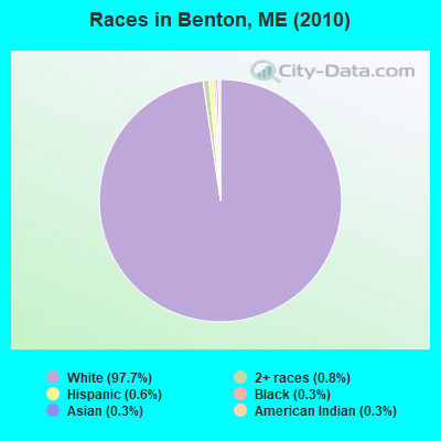
Races in Benton detailed stats: ancestries, foreign born residents, place of birth
According to our research of Maine and other state lists, there were 9 registered sex offenders living in Benton, Maine as of July 03, 2024.
The ratio of all residents to sex offenders in Benton is 304 to 1.
 Recent articles from our blog. Our writers, many of them Ph.D. graduates or candidates, create easy-to-read articles on a wide variety of topics.

 | Trying to find reasonably priced Full Red Pizza Sauce in Waterville. (10 replies) |
| Auto Repair Prices in Maine... (11 replies) |
| Is Maine sorta kinda like Michigan? (40 replies) |
| Unity maine or that area (7 replies) |
| Please help...opinions on Waterville-Benton (15 replies) |
| Bird information (12 replies) |
Latest news from Benton, ME collected exclusively by city-data.com from local newspapers, TV, and radio stations
Ancestries: French (26.1%), English (19.7%), Irish (13.4%), French Canadian (10.8%), United States (9.2%), Scotch-Irish (3.5%).
Current Local Time: EST time zone
Incorporated on 03/16/1842
Elevation: 109 feet
Land area: 28.4 square miles.
Population density: 96 people per square mile (very low).
17 residents are foreign born
| This town: | 0.7% |
| Maine: | 2.9% |
| Benton town: | 1.4% ($1,110) |
| Maine: | 1.5% ($1,417) |
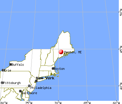
Nearest city with pop. 50,000+: Portland, ME  (74.4 miles , pop. 64,249).
Nearest city with pop. 200,000+: Boston, MA (176.0 miles , pop. 589,141).
Nearest city with pop. 1,000,000+: Bronx, NY (340.6 miles , pop. 1,332,650).
Nearest cities:
), ), ), Latitude: 44.60 N, Longitude: 69.53 W
Area code commonly used in this area: 207
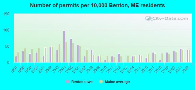
Single-family new house construction building permits:
- 2022: 10 buildings, average cost: $127,600
- 2021: 11 buildings, average cost: $127,600
- 2020: 9 buildings, average cost: $127,600
- 2019: 8 buildings, average cost: $127,600
- 2018: 2 buildings, average cost: $167,500
- 2017: 8 buildings, average cost: $111,900
- 2016: 4 buildings, average cost: $109,000
- 2015: 6 buildings, average cost: $134,600
- 2014: 5 buildings, average cost: $162,500
- 2012: 7 buildings, average cost: $105,000
- 2011: 5 buildings, average cost: $94,600
- 2010: 2 buildings, average cost: $50,000
- 2009: 5 buildings, average cost: $105,800
- 2008: 10 buildings, average cost: $117,000
- 2007: 5 buildings, average cost: $200,400
- 2006: 14 buildings, average cost: $124,000
- 2005: 19 buildings, average cost: $119,200
- 2004: 25 buildings, average cost: $90,500
- 2003: 10 buildings, average cost: $94,500
- 2002: 12 buildings, average cost: $68,700
- 2001: 5 buildings, average cost: $64,800
- 2000: 8 buildings, average cost: $74,000
- 1999: 7 buildings, average cost: $115,300
- 1998: 9 buildings, average cost: $96,000
- 1997: 5 buildings, average cost: $90,800

| Here: | 3.9% |
| Maine: | 3.4% |
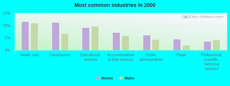
- Health care (11.7%)
- Construction (11.3%)
- Educational services (9.2%)
- Accommodation & food services (7.2%)
- Public administration (6.2%)
- Paper (4.6%)
- Professional, scientific, technical services (3.6%)
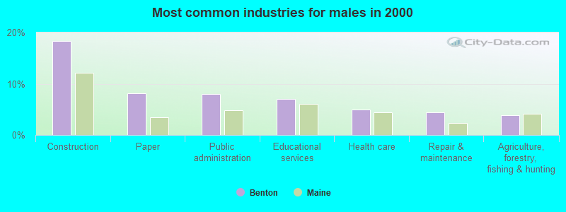
- Construction (18.3%)
- Paper (8.1%)
- Public administration (8.0%)
- Educational services (7.0%)
- Health care (4.9%)
- Repair & maintenance (4.5%)
- Agriculture, forestry, fishing & hunting (3.8%)
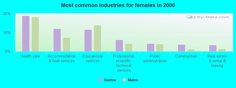
- Health care (19.0%)
- Accommodation & food services (12.0%)
- Educational services (11.7%)
- Professional, scientific, technical services (6.3%)
- Public administration (4.2%)
- Construction (3.7%)
- Real estate & rental & leasing (3.5%)

- Other sales and related occupations, including supervisors (5.9%)
- Secretaries and administrative assistants (5.8%)
- Driver/sales workers and truck drivers (5.5%)
- Other office and administrative support workers, including supervisors (4.1%)
- Vehicle and mobile equipment mechanics, installers, and repairers (3.7%)
- Cooks and food preparation workers (3.6%)
- Other management occupations, except farmers and farm managers (3.3%)
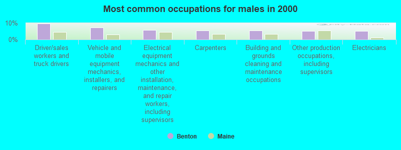
- Driver/sales workers and truck drivers (9.6%)
- Vehicle and mobile equipment mechanics, installers, and repairers (7.2%)
- Electrical equipment mechanics and other installation, maintenance, and repair workers, including supervisors (5.9%)
- Carpenters (5.6%)
- Building and grounds cleaning and maintenance occupations (5.4%)
- Other production occupations, including supervisors (5.3%)
- Electricians (5.3%)

- Secretaries and administrative assistants (12.2%)
- Other sales and related occupations, including supervisors (7.5%)
- Other office and administrative support workers, including supervisors (6.4%)
- Child care workers (5.9%)
- Nursing, psychiatric, and home health aides (5.2%)
- Other food preparation and serving workers, including supervisors (4.5%)
- Preschool, kindergarten, elementary, and middle school teachers (4.2%)
Average climate in Benton, Maine
Based on data reported by over 4,000 weather stations


Earthquake activity:
Benton-area historical earthquake activity is significantly above Maine state average. It is 78% smaller than the overall U.S. average.On 4/20/2002 at 10:50:47, a magnitude 5.3 (5.3 ML, Depth: 3.0 mi, Class: Moderate, Intensity: VI - VII) earthquake occurred 205.4 miles away from Benton center
On 10/16/2012 at 23:12:25, a magnitude 4.7 (4.7 ML, Depth: 10.0 mi, Class: Light, Intensity: IV - V) earthquake occurred 89.1 miles away from the city center
On 4/20/2002 at 10:50:47, a magnitude 5.2 (5.2 MB, 4.2 MS, 5.2 MW, 5.0 MW) earthquake occurred 206.6 miles away from Benton center
On 10/7/1983 at 10:18:46, a magnitude 5.3 (5.1 MB, 5.3 LG, 5.1 ML) earthquake occurred 242.4 miles away from the city center
On 1/19/1982 at 00:14:42, a magnitude 4.7 (4.5 MB, 4.7 MD, 4.5 LG) earthquake occurred 128.0 miles away from the city center
On 2/26/1999 at 03:38:43, a magnitude 3.8 (3.8 LG, Depth: 2.0 mi, Class: Light, Intensity: II - III) earthquake occurred 8.4 miles away from the city center
Magnitude types: regional Lg-wave magnitude (LG), body-wave magnitude (MB), duration magnitude (MD), local magnitude (ML), surface-wave magnitude (MS), moment magnitude (MW)
Natural disasters:
The number of natural disasters in Kennebec County (21) is greater than the US average (15).Major Disasters (Presidential) Declared: 16
Emergencies Declared: 4
Causes of natural disasters: Floods: 13, Storms: 11, Snows: 5, Hurricanes: 3, Heavy Rains: 2, Blizzard: 1, Ice Storm: 1, Snowfall: 1, Wind: 1, Other: 2 (Note: some incidents may be assigned to more than one category).

Hospitals and medical centers near Benton:
- HEALTHREACH HOSPICE (Hospital, about 6 miles away; WATERVILLE, ME)
- MOUNT ST JOSEPH NURSING HOME (Nursing Home, about 6 miles away; WATERVILLE, ME)
- WILLOWS NURSING CARE CENTER (Nursing Home, about 6 miles away; WATERVILLE, ME)
- HEALTHREACH HOMECARE AND HOSPICE (Home Health Center, about 7 miles away; WATERVILLE, ME)
- OAK GROVE CENTER (Nursing Home, about 7 miles away; WATERVILLE, ME)
- INLAND HOSPITAL Acute Care Hospitals (about 8 miles away; WATERVILLE, ME)
- LAKEWOOD (Nursing Home, about 8 miles away; WATERVILLE, ME)
Colleges/universities with over 2000 students nearest to Benton:
- University of Maine at Augusta (about 23 miles; Augusta, ME; Full-time enrollment: 3,204)
- University of Maine at Farmington (about 31 miles; Farmington, ME; FT enrollment: 2,036)
- Husson University (about 40 miles; Bangor, ME; FT enrollment: 2,421)
- University of Maine (about 47 miles; Orono, ME; FT enrollment: 8,931)
- Saint Joseph's College of Maine (about 72 miles; Standish, ME; FT enrollment: 2,010)
- Southern Maine Community College (about 75 miles; South Portland, ME; FT enrollment: 4,666)
- University of Southern Maine (about 75 miles; Portland, ME; FT enrollment: 6,647)
Public elementary/middle school in Benton:
- BENTON ELEMENTARY SCHOOL (Students: 675, Location: 68 SCHOOL DRIVE, Grades: 1-6)
Points of interest:
Cemeteries: Ames Cemetery (1), Reed Cemetery (2), Brown Cemetery (3), Holt Cemetery (4). Display/hide their locations on the map
Birthplace of: Albert W. Grant - Navy admiral, Brian L. Buker - Army Medal of Honor recipient, Bruce Bickford (athlete) - Athletics competitor.
Drinking water stations with addresses in Benton and their reported violations in the past:
AVERILLS MOBILE HOME PARK (Population served: 78, Groundwater):Past monitoring violations:TOWN AND COUNTRY WAYS MHP (Population served: 75, Groundwater):
- Monitoring and Reporting (DBP) - Between JAN-2011 and DEC-2013, Contaminant: Total Haloacetic Acids (HAA5). Follow-up actions: St Public Notif requested (NOV-08-2012), St Formal NOV issued (NOV-08-2012), St Public Notif received (DEC-31-2012)
- Monitoring and Reporting (DBP) - Between JAN-2011 and DEC-2013, Contaminant: TTHM. Follow-up actions: St Public Notif requested (NOV-08-2012), St Formal NOV issued (NOV-08-2012), St Public Notif received (DEC-31-2012)
- 2 routine major monitoring violations
Past monitoring violations:
- Follow-up Or Routine LCR Tap M/R - In OCT-01-2010, Contaminant: Lead and Copper Rule. Follow-up actions: St Public Notif requested (FEB-15-2011), St Formal NOV issued (FEB-15-2011), St Compliance achieved (MAY-08-2012), St Public Notif received (JUN-25-2012)
- Initial Tap Sampling for Pb and Cu - In JAN-01-1994, Contaminant: Lead and Copper Rule. Follow-up actions: Fed Formal NOV issued (JUN-12-1996), Fed FAO issued (MAR-29-1997)
- Initial Tap Sampling for Pb and Cu - In JUL-01-1993, Contaminant: Lead and Copper Rule. Follow-up actions: St Formal NOV issued (NOV-01-1994), Fed FAO issued (MAR-29-1997)
- 2 routine major monitoring violations
- 6 regular monitoring violations
| This town: | 2.5 people |
| Maine: | 2.3 people |
| This town: | 71.7% |
| Whole state: | 62.9% |
| This town: | 9.5% |
| Whole state: | 9.4% |
Likely homosexual households (counted as self-reported same-sex unmarried-partner households)
- Lesbian couples: 0.2% of all households
- Gay men: 0.5% of all households
| This town: | 10.2% |
| Whole state: | 10.9% |
| This town: | 5.1% |
| Whole state: | 4.1% |
For population 15 years and over in Benton:
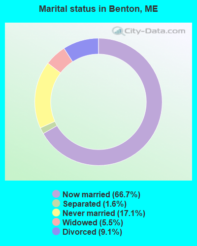
- Never married: 17.1%
- Now married: 66.7%
- Separated: 1.6%
- Widowed: 5.5%
- Divorced: 9.1%
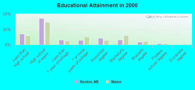
For population 25 years and over in Benton:
- High school or higher: 82.6%
- Bachelor's degree or higher: 13.9%
- Graduate or professional degree: 6.2%
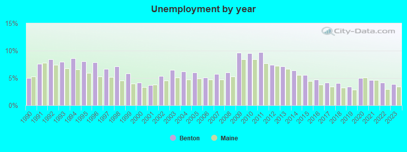
- Unemployed: 4.5%
- Mean travel time to work (commute): 21.7 minutes

| Here: | 10.3 |
| Maine average: | 11.2 |
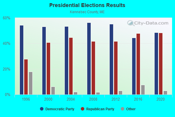
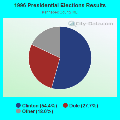
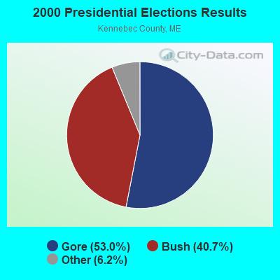
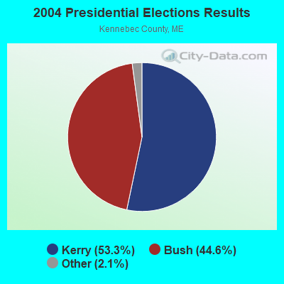
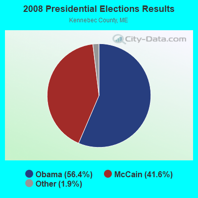
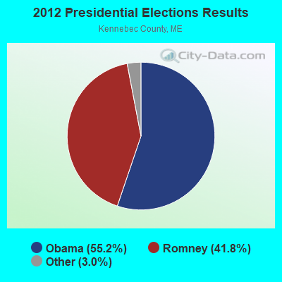
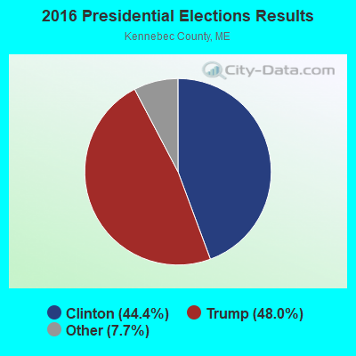
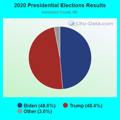
Graphs represent county-level data. Detailed 2008 Election Results
Religion statistics for Benton, ME (based on Kennebec County data)
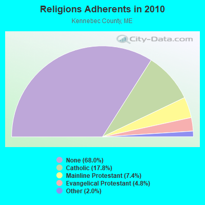
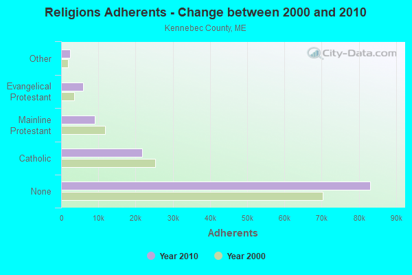
| Religion | Adherents | Congregations |
|---|---|---|
| Catholic | 21,758 | 11 |
| Mainline Protestant | 8,999 | 60 |
| Evangelical Protestant | 5,829 | 56 |
| Other | 2,466 | 17 |
| None | 83,099 | - |
Food Environment Statistics:
| This county: | 1.99 / 10,000 pop. |
| State: | 2.80 / 10,000 pop. |
| Here: | 0.17 / 10,000 pop. |
| Maine: | 0.14 / 10,000 pop. |
| Kennebec County: | 1.41 / 10,000 pop. |
| State: | 2.20 / 10,000 pop. |
| This county: | 6.38 / 10,000 pop. |
| State: | 5.75 / 10,000 pop. |
| Kennebec County: | 8.70 / 10,000 pop. |
| Maine: | 11.02 / 10,000 pop. |
| Here: | 8.6% |
| State: | 8.2% |
| Kennebec County: | 28.2% |
| Maine: | 25.0% |
Strongest AM radio stations in Benton:
- WSKW (1160 AM; 10 kW; SKOWHEGAN, ME; Owner: MOUNTAIN WIRELESS, INCORPORATED)
- WTVL (1490 AM; 1 kW; WATERVILLE, ME; Owner: CITADEL BROADCASTING COMPANY)
- WTME (780 AM; 10 kW; RUMFORD, ME; Owner: MOUNTAIN VALLEY BROADCASTING, INC.)
- WFAU (1280 AM; 5 kW; GARDINER, ME; Owner: CAPSTAR TX LIMITED PARTNERSHIP)
- WZON (620 AM; 5 kW; BANGOR, ME; Owner: THE ZONE CORPORATION)
- WABI (910 AM; 5 kW; BANGOR, ME; Owner: CLEAR CHANNEL BROADCASTING LICENSES, INC.)
- WRKO (680 AM; 50 kW; BOSTON, MA; Owner: ENTERCOM BOSTON LICENSE, LLC)
- WMTW (870 AM; 10 kW; GORHAM, ME; Owner: RADIO PARTNERS OF MAINE, L.P.)
- WEEI (850 AM; 50 kW; BOSTON, MA; Owner: ENTERCOM BOSTON LICENSE, LLC)
- WBZ (1030 AM; 50 kW; BOSTON, MA; Owner: INFINITY BROADCASTING OPERATIONS, INC.)
- WMDR (1340 AM; 1 kW; AUGUSTA, ME; Owner: LIGHT OF LIFE MINISTRIES, INC.)
- WGAN (560 AM; 5 kW; PORTLAND, ME; Owner: SAGA COMMUNICATIONS OF NEW ENGLAND, LLC)
- WCRN (830 AM; 50 kW; WORCESTER, MA; Owner: CARTER BROADCASTING CORPORATION)
Strongest FM radio stations in Benton:
- WCTB (93.5 FM; FAIRFIELD, ME; Owner: MOUNTAIN WIRELESS, INC.)
- WEBB (98.5 FM; WATERVILLE, ME; Owner: CITADEL BROADCASTING COMPANY)
- WWWA (95.3 FM; WINSLOW, ME; Owner: LIGHT OF LIFE MINISTRIES, INC.)
- WHQO (107.9 FM; SKOWHEGAN, ME; Owner: MOUNTAIN WIRELESS, INC.)
- WWBX (97.1 FM; BANGOR, ME; Owner: CLEAR CHANNEL BROADCASTING LICENSES, INC.)
- WMEW (91.3 FM; WATERVILLE, ME; Owner: MAINE PUBLIC BROADCASTING CORPORATION)
- WTOS-FM (105.1 FM; SKOWHEGAN, ME; Owner: CAPSTAR TX LIMITED PARTNERSHIP)
- WMEP (90.5 FM; CAMDEN, ME; Owner: MAINE PUBLIC BROADCASTING CORP.)
- WQSS (102.5 FM; CAMDEN, ME; Owner: CLEAR CHANNEL BROADCASTING LICENSES, INC.)
- WBFB (104.7 FM; BELFAST, ME; Owner: CLEAR CHANNEL BROADCASTING LICENSES, INC.)
- WMME-FM (92.3 FM; AUGUSTA, ME; Owner: CITADEL BROADCASTING COMPANY)
- WQCB (106.5 FM; BREWER, ME; Owner: CUMULUS LICENSING CORP.)
- WFZX (101.7 FM; SEARSPORT, ME; Owner: CLEAR CHANNEL BROADCASTING LICENSES, INC.)
- WMHB (89.7 FM; WATERVILLE, ME; Owner: THE MAYFLOWER HILL BROADCASTING. CORP.)
- WLOB-FM (96.3 FM; RUMFORD, ME; Owner: ATLANTIC COAST RADIO, LLC)
- WKIT-FM (100.3 FM; BREWER, ME; Owner: THE ZONE CORPORATION)
- WGUY (102.1 FM; DEXTER, ME; Owner: CONCORD MEDIA GROUP, INC.)
- WMCM (103.3 FM; ROCKLAND, ME; Owner: CLEAR CHANNEL BROADCASTING LICENSES, INC.)
- WJCX (99.5 FM; PITTSFIELD, ME; Owner: CSN INTERNATIONAL)
- WABK-FM (104.3 FM; GARDINER, ME; Owner: CAPSTAR TX LIMITED PARTNERSHIP)
TV broadcast stations around Benton:
- WFYW-LP (Channel 69; FAIRFIELD/WATERVILLE, ME; Owner: THREE ANGELS BROADCASTING NETWORK, INC.)
- WABI-TV (Channel 5; BANGOR, ME; Owner: COMMUNITY BROADCASTING SERVICE)
- DW23AB (Channel 23; WATERVILLE, ME; Owner: RUSSELL COMMUNICATIONS)
- WGCI-LP (Channel 4; WATERVILLE, ME; Owner: PACIFIC AND SOUTHERN COMPANY, INC.)
- W36CK (Channel 36; BANGOR, ME; Owner: TRINITY BROADCASTING NETWORK)
Medal of Honor Recipients
Medal of Honor Recipients born in Benton: Brian L. Buker, Frank W. Haskell.
- National Bridge Inventory (NBI) Statistics
- 7Number of bridges
- 233ft / 70.8mTotal length
- 41,638Total average daily traffic
- 2,079Total average daily truck traffic
- 58,470Total future (year 2036) average daily traffic
FCC Registered Cell Phone Towers:
1 (See the full list of FCC Registered Cell Phone Towers in Benton)FCC Registered Antenna Towers:
8 (See the full list of FCC Registered Antenna Towers)FCC Registered Amateur Radio Licenses:
10 (See the full list of FCC Registered Amateur Radio Licenses in Benton)FAA Registered Aircraft:
5- Aircraft: MOONEY M20E (Category: Land, Seats: 4, Weight: Up to 12,499 Pounds, Speed: 127 mph), Engine: LYCOMING I0360 SER (180 HP) (Reciprocating)
N-Number: 1289X, N1289X, N-1289X, Serial Number: 162, Year manufactured: 1963, Airworthiness Date: 10/23/1963, Certificate Issue Date: 07/11/2012
Registrant (Individual): David C Young, 467 Bangor Rd, Benton, ME 04901 - Aircraft: ROCKWELL INTERNATIONAL 114 (Category: Land, Seats: 4, Weight: Up to 12,499 Pounds, Speed: 128 mph), Engine: LYCOMING IO-540-T4A5D (260 HP) (Reciprocating)
N-Number: 1907J, N1907J, N-1907J, Serial Number: 14007, Year manufactured: 1976, Airworthiness Date: 06/30/1976, Certificate Issue Date: 07/15/1989
Registrant (Individual): Allan M Fuller, 304 Unity Rd, Benton, ME 04901 - Aircraft: THOMPSON MICHAEL D A01WS (Category: Amphibian, Seats: 2, Weight: Up to 12,499 Pounds), Engine: ROTAX SEE BOMBADIER (Reciprocating)
N-Number: 381MT, N381MT, N-381MT, Serial Number: T001WS, Year manufactured: 2011, Airworthiness Date: 06/29/2011, Certificate Issue Date: 05/26/2009
Registrant (Individual): Michael D Thompson, 838 Unity Rd, Benton, ME 04901 - Aircraft: PIPER PA-28-140 (Category: Land, Seats: 4, Weight: Up to 12,499 Pounds, Speed: 107 mph), Engine: LYCOMING 0-320 SERIES (180 HP) (Reciprocating)
N-Number: 4697R, N4697R, N-4697R, Serial Number: 28-21461, Year manufactured: 1966, Airworthiness Date: 02/24/1966, Certificate Issue Date: 01/15/2004
Registrant (Co-Owned): Karl R Trustee Wiggin, 1209 Unity Rd, Benton, ME 04901, Other Owners: Linda L Trustee Wiggin - Aircraft: THOMPSON MICHAEL D CH2 (Category: Land, Seats: 2, Weight: Up to 12,499 Pounds), Engine: ROTAX 503 DCDI (52 HP) (2 Cycle)
N-Number: 4329G, N4329G, N-4329G, Serial Number: CH2T397, Year manufactured: 2007, Airworthiness Date: 01/22/2010, Certificate Issue Date: 10/02/2006
Registrant (Individual): Michael D Thompson, 838 Unity Rd, Benton, ME 04901
2003 - 2018 National Fire Incident Reporting System (NFIRS) incidents
- Fire incident types reported to NFIRS in Benton, ME
- 13662.7%Structure Fires
- 3817.5%Mobile Property/Vehicle Fires
- 3717.1%Outside Fires
- 62.8%Other
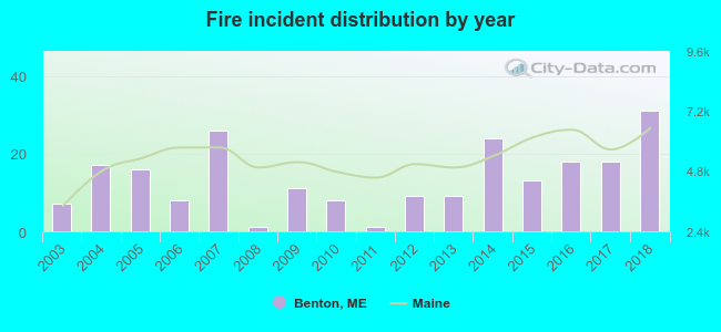 According to the data from the years 2003 - 2018 the average number of fires per year is 14. The highest number of fire incidents - 31 took place in 2018, and the least - 1 in 2008. The data has a rising trend.
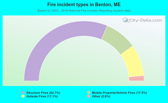 When looking into fire subcategories, the most incidents belonged to: Structure Fires (62.7%), and Mobile Property/Vehicle Fires (17.5%).
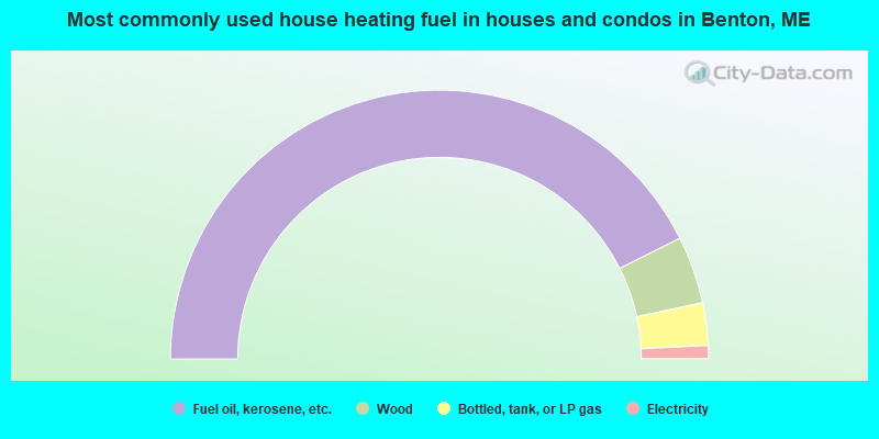
- 85.2%Fuel oil, kerosene, etc.
- 8.1%Wood
- 5.1%Bottled, tank, or LP gas
- 1.6%Electricity
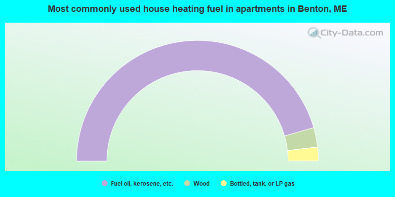
- 91.0%Fuel oil, kerosene, etc.
- 5.2%Wood
- 3.7%Bottled, tank, or LP gas
Benton compared to Maine state average:
- Unemployed percentage below state average.
- Black race population percentage significantly below state average.
- Hispanic race population percentage significantly below state average.
- Foreign-born population percentage significantly below state average.
- Renting percentage significantly below state average.
- Length of stay since moving in significantly above state average.
- Number of rooms per house significantly below state average.
- House age significantly below state average.
- Percentage of population with a bachelor's degree or higher below state average.

|
Total of 23 patent applications in 2008-2024.