Atlanta, Idaho
Submit your own pictures of this place and show them to the world
- OSM Map
- General Map
- Google Map
- MSN Map

| Males: 168 | |
| Females: 155 |
| Median resident age: | 49.0 years |
| Idaho median age: | 33.2 years |
Zip code: 83647
| Atlanta: | $50,940 |
| ID: | $72,785 |
Estimated per capita income in 2022: $29,658 (it was $16,881 in 2000)
Atlanta CCD income, earnings, and wages data
Estimated median house or condo value in 2022: $238,098 (it was $69,000 in 2000)
| Atlanta: | $238,098 |
| ID: | $432,500 |
Detailed information about poverty and poor residents in Atlanta, ID


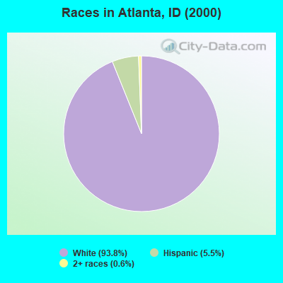
- 30593.8%White alone
- 185.5%Hispanic
- 20.6%Two or more races
Races in Atlanta detailed stats: ancestries, foreign born residents, place of birth
 Recent articles from our blog. Our writers, many of them Ph.D. graduates or candidates, create easy-to-read articles on a wide variety of topics.

Current Local Time: MST time zone
Elevation: 5383 feet
Land area: 1305.4 square miles.
Population density: 0.2 people per square mile (very low).
| Atlanta CCD: | 0.8% ($581) |
| Idaho: | 1.0% ($1,007) |
Nearest city with pop. 50,000+: Boise, ID  (44.7 miles , pop. 185,787).
Nearest city with pop. 200,000+: Northwest Clackamas, OR (380.3 miles , pop. 224,220).
Nearest city with pop. 1,000,000+: Los Angeles, CA (675.8 miles , pop. 3,694,820).
Nearest cities:
), ), ), Latitude: 43.57 N, Longitude: 115.35 W
Area code: 208


| Here: | 3.1% |
| Idaho: | 3.1% |
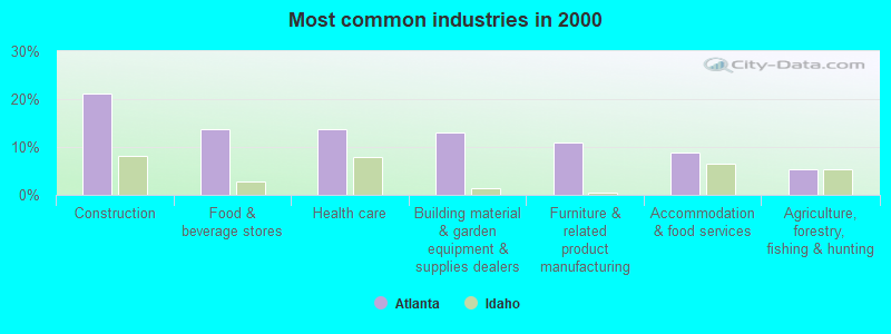
- Construction (21.1%)
- Food & beverage stores (13.6%)
- Health care (13.6%)
- Building material & garden equipment & supplies dealers (12.9%)
- Furniture & related product manufacturing (10.9%)
- Accommodation & food services (8.8%)
- Agriculture, forestry, fishing & hunting (5.4%)
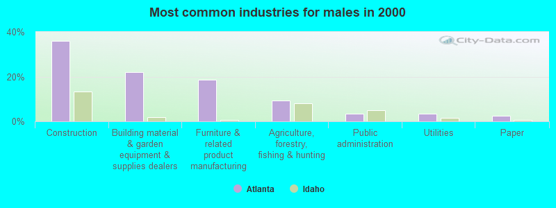
- Construction (36.0%)
- Building material & garden equipment & supplies dealers (22.1%)
- Furniture & related product manufacturing (18.6%)
- Agriculture, forestry, fishing & hunting (9.3%)
- Public administration (3.5%)
- Utilities (3.5%)
- Paper (2.3%)

- Food & beverage stores (32.8%)
- Health care (32.8%)
- Accommodation & food services (21.3%)
- Educational services (8.2%)
- Utilities (4.9%)
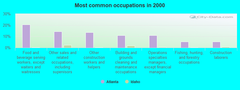
- Food and beverage serving workers, except waiters and waitresses (20.4%)
- Other sales and related occupations, including supervisors (14.3%)
- Other construction workers and helpers (13.6%)
- Building and grounds cleaning and maintenance occupations (10.9%)
- Operations specialties managers, except financial managers (10.9%)
- Fishing, hunting, and forestry occupations (5.4%)
- Construction laborers (5.4%)
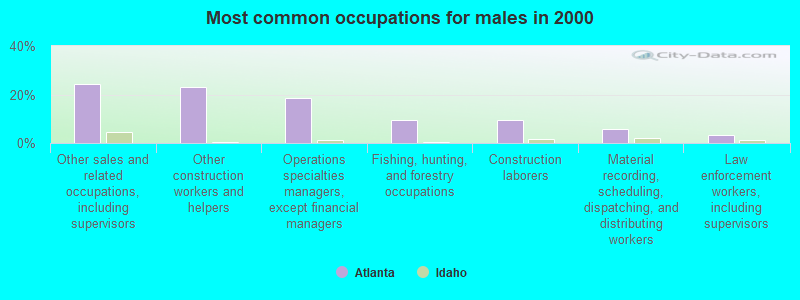
- Other sales and related occupations, including supervisors (24.4%)
- Other construction workers and helpers (23.3%)
- Operations specialties managers, except financial managers (18.6%)
- Fishing, hunting, and forestry occupations (9.3%)
- Construction laborers (9.3%)
- Material recording, scheduling, dispatching, and distributing workers (5.8%)
- Law enforcement workers, including supervisors (3.5%)
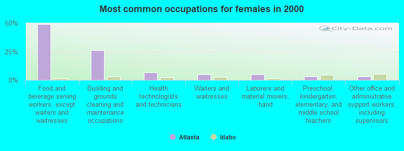
- Food and beverage serving workers, except waiters and waitresses (49.2%)
- Building and grounds cleaning and maintenance occupations (26.2%)
- Health technologists and technicians (6.6%)
- Waiters and waitresses (4.9%)
- Laborers and material movers, hand (4.9%)
- Preschool, kindergarten, elementary, and middle school teachers (3.3%)
- Other office and administrative support workers, including supervisors (3.3%)
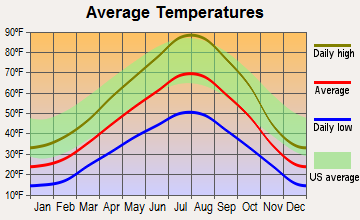
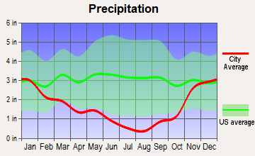
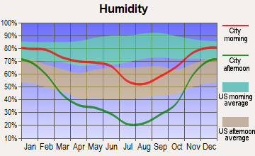
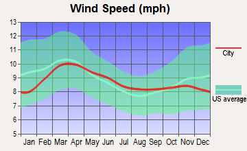
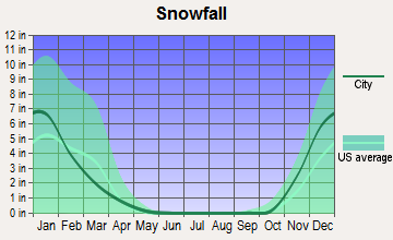
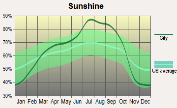
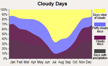
Average climate in Atlanta, Idaho
Based on data reported by over 4,000 weather stations
Earthquake activity:
Atlanta-area historical earthquake activity is significantly above Idaho state average. It is 2108% greater than the overall U.S. average.On 10/28/1983 at 14:06:06, a magnitude 7.3 (6.2 MB, 7.3 MS, 7.0 MW, Class: Major, Intensity: VIII - XII) earthquake occurred 84.7 miles away from the city center, causing 2 deaths (2 shaking deaths) and 3 injuries, causing $15,000,000 total damage
On 8/18/1959 at 06:37:13, a magnitude 7.7 (7.7 UK) earthquake occurred 243.1 miles away from Atlanta center, causing $26,000,000 total damage
On 10/3/1915 at 06:52:48, a magnitude 7.6 (7.6 UK) earthquake occurred 239.3 miles away from the city center
On 3/31/2020 at 23:52:30, a magnitude 6.5 (6.5 MW, Depth: 7.5 mi, Class: Strong, Intensity: VII - IX) earthquake occurred 63.0 miles away from the city center
On 12/16/1954 at 11:07:12, a magnitude 7.0 (7.0 UK) earthquake occurred 332.0 miles away from Atlanta center
On 12/21/1932 at 06:10:09, a magnitude 7.2 (7.2 UK) earthquake occurred 377.9 miles away from the city center
Magnitude types: body-wave magnitude (MB), surface-wave magnitude (MS), moment magnitude (MW)
Natural disasters:
The number of natural disasters in Elmore County (8) is smaller than the US average (15).Major Disasters (Presidential) Declared: 3
Emergencies Declared: 2
Causes of natural disasters: Floods: 4, Drought: 1, Fire: 1, Heavy Rain: 1, Hurricane: 1, Landslide: 1, Mudslide: 1, Storm: 1, Winter Storm: 1, Other: 1 (Note: some incidents may be assigned to more than one category).
Airports and heliports located in Atlanta:
- Graham Usfs Airport (U45) (Runways: 1, Air Taxi Ops: 100, Itinerant Ops: 800)
- Weatherby Usfs Airport (52U) (Runways: 1, Itinerant Ops: 750, Military Ops: 25)
- Atlanta Airport (55H) (Runways: 1, Air Taxi Ops: 100, Itinerant Ops: 500)
- Dorothy Roeber Memorial Heliport (36ID)
Colleges/universities with over 2000 students nearest to Atlanta:
- Boise State University (about 44 miles; Boise, ID; Full-time enrollment: 16,774)
- College of Western Idaho (about 59 miles; Nampa, ID; FT enrollment: 6,300)
- Northwest Nazarene University (about 62 miles; Nampa, ID; FT enrollment: 2,290)
- College of Southern Idaho (about 82 miles; Twin Falls, ID; FT enrollment: 5,051)
- Treasure Valley Community College (about 87 miles; Ontario, OR; FT enrollment: 2,055)
- Idaho State University (about 155 miles; Pocatello, ID; FT enrollment: 10,350)
- Brigham Young University-Idaho (about 179 miles; Rexburg, ID; FT enrollment: 30,522)
Points of interest:
Notable locations in Atlanta: Rattlesnake Campground (A), Ninemeyer Campground (B), Willow Creek Campground (C), Johnson Creek Campground (D), Willow Creek Campground (E), Riverside Campground (F), Rocky Bar Guard Station (G), Dutch Creek Forest Service Station (H), Long Gulch Guard Station (I), Little Camas Reservoir Access Area (J), Shake Creek Ranger Station (K), Bird Creek Campground (L), Big Trinity lake Campground (M), Overlook Mill (N), Kelley Creek Corral (O), Chaparral Campground (P), Elk Spring Campground (Q), Pine AIrport Boat Ramp (R), Idaho State Highway Maintenance Station (S), Pine Recreation Site (T). Display/hide their locations on the map
Lakes, reservoirs, and swamps: Leggit Lake (A), Little Rainbow Lake (B), Little Roaring River Lake (C), Little Spangle Lake (D), Little Trinity Lake (E), Lodgepole Lake (F), Spangle Lakes (G), Low Pass Lake (H). Display/hide their locations on the map
Streams, rivers, and creeks: China Fork (A), Charcoal Creek (B), Cat Creek (C), Castle Creek (D), Casey Creek (E), Chimney Creek (F), Campo Creek (G), Cahhah Creek (H), Byron Creek (I). Display/hide their locations on the map
Park in Atlanta: Soldier Mountain Game Preserve (1). Display/hide its location on the map
| This place: | 1.9 people |
| Idaho: | 2.7 people |
| This place: | 58.9% |
| Whole state: | 69.6% |
| This place: | 3.3% |
| Whole state: | 6.3% |
Likely homosexual households (counted as self-reported same-sex unmarried-partner households)
- Lesbian couples: 0.7% of all households
- Gay men: 0.0% of all households
| This place: | 15.7% |
| Whole state: | 11.8% |
| This place: | 6.7% |
| Whole state: | 4.6% |
For population 15 years and over in Atlanta:
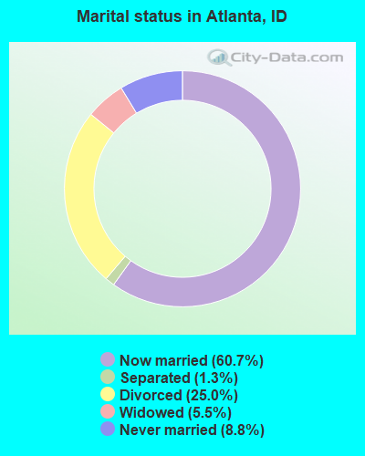
- Never married: 8.8%
- Now married: 60.7%
- Separated: 1.3%
- Widowed: 5.5%
- Divorced: 25.0%
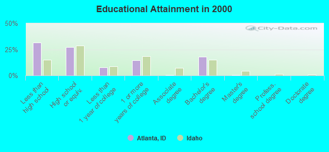
For population 25 years and over in Atlanta:
- High school or higher: 68.6%
- Bachelor's degree or higher: 18.2%
- Graduate or professional degree: 0.3%
- Unemployed: 1.3%
- Mean travel time to work (commute): 19.8 minutes

| Here: | 11.0 |
| Idaho average: | 11.1 |
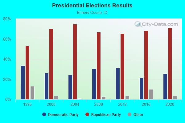
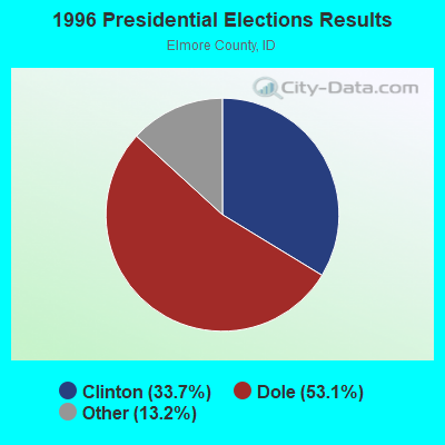


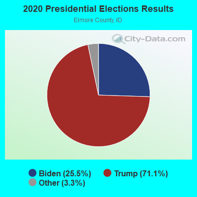
Graphs represent county-level data. Detailed 2008 Election Results
Religion statistics for Atlanta, ID (based on Elmore County data)
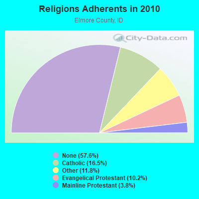
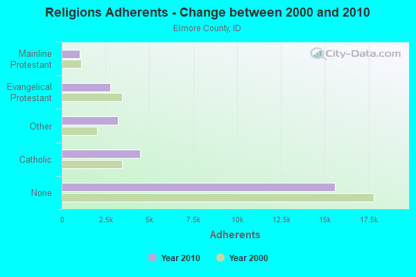
| Religion | Adherents | Congregations |
|---|---|---|
| Catholic | 4,461 | 3 |
| Other | 3,196 | 9 |
| Evangelical Protestant | 2,768 | 21 |
| Mainline Protestant | 1,029 | 8 |
| None | 15,584 | - |
Food Environment Statistics:
| Elmore County: | 1.39 / 10,000 pop. |
| Idaho: | 1.88 / 10,000 pop. |
| This county: | 0.35 / 10,000 pop. |
| State: | 0.28 / 10,000 pop. |
| Elmore County: | 1.04 / 10,000 pop. |
| Idaho: | 0.53 / 10,000 pop. |
| Elmore County: | 2.77 / 10,000 pop. |
| State: | 3.87 / 10,000 pop. |
| Here: | 6.58 / 10,000 pop. |
| State: | 7.75 / 10,000 pop. |
| This county: | 7.7% |
| Idaho: | 7.7% |
| Elmore County: | 32.1% |
| Idaho: | 25.7% |
| This county: | 14.3% |
| State: | 11.7% |
13.07% of this county's 2021 resident taxpayers lived in other counties in 2020 ($47,889 average adjusted gross income)
| Here: | 13.07% |
| Idaho average: | 9.53% |
1.11% of residents moved from foreign countries ($4,012 average AGI)
Elmore County: 1.11% Idaho average: 0.03%
Top counties from which taxpayers relocated into this county between 2020 and 2021:
| from Ada County, ID | |
| from Canyon County, ID | |
| from Twin Falls County, ID |
11.74% of this county's 2020 resident taxpayers moved to other counties in 2021 ($40,742 average adjusted gross income)
| Here: | 11.74% |
| Idaho average: | 7.66% |
0.82% of residents moved to foreign countries ($2,934 average AGI)
Elmore County: 0.82% Idaho average: 0.02%
Top counties to which taxpayers relocated from this county between 2020 and 2021:
| to Ada County, ID | |
| to Canyon County, ID | |
| to Owyhee County, ID |
Strongest AM radio stations in Atlanta:
- KBOI (670 AM; 50 kW; BOISE, ID; Owner: CITADEL BROADCASTING COMPANY)
- KBSU (730 AM; 15 kW; BOISE, ID; Owner: IDAHO STATE BOARD OF EDUCATION)
- KWEI (1260 AM; 50 kW; WEISER, ID; Owner: TREASURE VALLEY BROADCASTING CO.)
- KGEM (1140 AM; 10 kW; BOISE, ID; Owner: JOURNAL BROADCAST CORPORATION)
- KFXD (630 AM; 5 kW; BOISE, ID; Owner: CITICASTERS LICENSES, L.P.)
- KIDO (580 AM; 5 kW; NAMPA, ID; Owner: CITICASTERS LICENSES, L.P.)
- KBGN (1060 AM; daytime; 10 kW; CALDWELL, ID; Owner: NELSON M. AND KAREN E. WILSON)
- KTIK (1350 AM; 5 kW; NAMPA, ID; Owner: CITADEL BROADCASTING COMPANY)
- KRXR (1480 AM; 5 kW; GOODING, ID; Owner: MARIA ELENA JUAREZ)
- KKIC (950 AM; 4 kW; BOISE, ID; Owner: WESTERN PACIFIC, INC)
- KALL (700 AM; 50 kW; NORTH SALT LAKE CITY, UT; Owner: CITICASTERS LICENSES, L.P.)
- KERR (750 AM; 50 kW; POLSON, MT; Owner: ANDERSON RADIO BROADCASTING, INC.)
- KIQN (1010 AM; 50 kW; TOOELE, UT)
Strongest FM radio stations in Atlanta:
- KTPZ (99.1 FM; MOUNTAIN HOME, ID; Owner: AGM-IDAHO BROADCASTING, LLC)
- KBSX (91.5 FM; BOISE, ID; Owner: IDAHO STATE BOARD OF EDUCATION)
- KIZN (92.3 FM; BOISE, ID; Owner: CITADEL BROADCASTING COMPANY)
- KKGL (96.9 FM; NAMPA, ID; Owner: CITADEL BROADCASTING COMPANY)
- KQFC (97.9 FM; BOISE, ID; Owner: CITADEL BROADCASTING COMPANY)
- KZMG (93.1 FM; NEW PLYMOUTH, ID; Owner: CITADEL BROADCASTING COMPANY)
- KBSU-FM (90.3 FM; BOISE, ID; Owner: IDAHO STATE BOARD OF EDUCATION)
- KCIX (105.9 FM; GARDEN CITY, ID; Owner: CITICASTERS LICENSES, L.P.)
- KRVB (94.9 FM; NAMPA, ID; Owner: JOURNAL BROADCAST CORPORATION)
- KXLT-FM (107.9 FM; EAGLE, ID; Owner: CITICASTERS LICENSES, L.P.)
- KJOT (105.1 FM; BOISE, ID; Owner: JOURNAL BROADCAST CORPORATION)
- KTHI (107.1 FM; CALDWELL, ID; Owner: JOURNAL BROADCAST CORPORATION)
- KBXL (94.1 FM; CALDWELL, ID; Owner: KSPD, INC.)
- KTSY (89.5 FM; CALDWELL, ID; Owner: GEM STATE ADVENTIST ACADEMY)
- KSAS-FM (103.3 FM; CALDWELL, ID; Owner: CITICASTERS LICENSES, L.P.)
- KLTB (104.3 FM; BOISE, ID; Owner: CITICASTERS LICENSES, L.P.)
- KECH-FM (95.3 FM; SUN VALLEY, ID; Owner: ALPINE BROADCASTING LTD PARTNERSHIP)
- KYZK (107.5 FM; SUN VALLEY, ID; Owner: ALPINE BROADCASTING, LTD.)
- KJHY (101.9 FM; EMMETT, ID; Owner: CAPITAL WEST INC)
- KIKX (104.7 FM; KETCHUM, ID; Owner: AGM-IDAHO BROADCASTING, LLC)
FCC Registered Microwave Towers:
2- JAMES CREEK, 1/4 Mi. From James Crk Rd. (Lat: 43.773500 Lon: -115.221750), Type: Tower, Structure height: 9.1 m, Overall height: 12.2 m, Call Sign: WLN930,
Assigned Frequencies: 6605.00 MHz, 6765.00 MHz, Grant Date: 12/10/2019, Expiration Date: 01/01/2030, Registrant: Lukas, Nace, Gutierrez & Sachs, LLP, 1650 Tysons Blvd., Suite 1500, Mclean, VA 22102, Phone: (703) 584-8665, Fax: (703) 584-8695, Email:
- ATLANTA CO, Power House Road (Lat: 43.804333 Lon: -115.118944), Type: Tower, Structure height: 4.6 m, Overall height: 6.1 m, Call Sign: WLN931,
Assigned Frequencies: 6765.00 MHz, Grant Date: 03/09/2021, Expiration Date: 02/01/2031, Registrant: Rural Telephone Company, 892 W. Madison Ave., Glenns Ferry, ID 83623, Phone: (208) 366-2614, Fax: (208) 366-2615
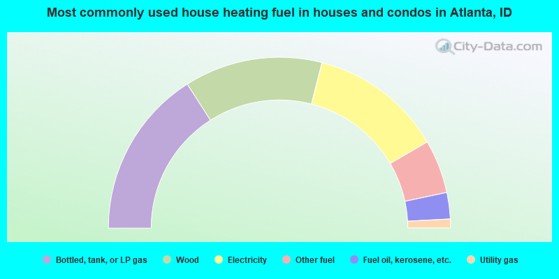
- 31.9%Bottled, tank, or LP gas
- 26.1%Wood
- 25.2%Electricity
- 10.1%Other fuel
- 5.0%Fuel oil, kerosene, etc.
- 1.7%Utility gas
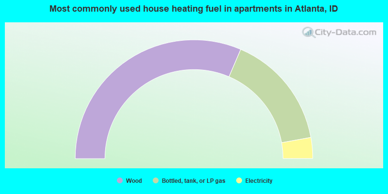
- 62.9%Wood
- 31.4%Bottled, tank, or LP gas
- 5.7%Electricity
Atlanta compared to Idaho state average:
- Median house value below state average.
- Unemployed percentage significantly below state average.
- Black race population percentage significantly below state average.
- Hispanic race population percentage below state average.
- Median age above state average.
- Foreign-born population percentage significantly below state average.
- Length of stay since moving in significantly above state average.
- Number of rooms per house significantly below state average.
- House age significantly below state average.
- Number of college students significantly below state average.