Alliance, Nebraska
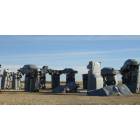
Alliance: Carhenge

Alliance: Romance at th Fountain

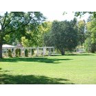
Alliance: Alliance, NE Central Park Fountain in the summer
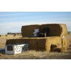
Alliance: Rest area in Alliance, NE
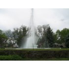
Alliance: city fountain
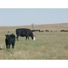
Alliance: Catte in the surrounding Box Butte County Area
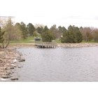
Alliance: Laing Lake
Alliance: Historic Central Park Sunken Gardens-Product of WPA projects

Alliance: Sunrise over Carhenge

Alliance: Hibiscus in bloom at the Conservatory
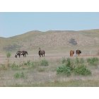
Alliance: Horses in the nearby Sandhills east of Alliance
- see
16
more - add
your


Submit your own pictures of this city and show them to the world
- OSM Map
- General Map
- Google Map
- MSN Map
Population change since 2000: -10.3%
 |
| Males: 4,055 | |
| Females: 3,982 |
| Median resident age: | 39.4 years |
| Nebraska median age: | 37.4 years |
Zip codes: 69301.
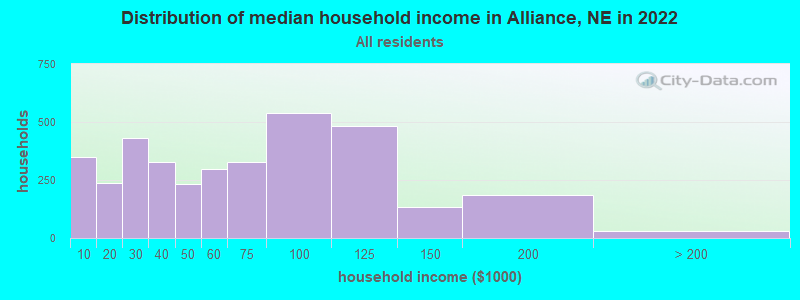
| Alliance: | $56,489 |
| NE: | $69,597 |
Estimated per capita income in 2022: $30,335 (it was $18,584 in 2000)
Alliance city income, earnings, and wages data
Estimated median house or condo value in 2022: $178,369 (it was $68,300 in 2000)
| Alliance: | $178,369 |
| NE: | $232,400 |
Mean prices in 2022: all housing units: $189,919; detached houses: $197,377; townhouses or other attached units: $182,875; in 3-to-4-unit structures: $253,083; mobile homes: $88,437
Median gross rent in 2022: $725.
(13.7% for White Non-Hispanic residents, 7.0% for Hispanic or Latino residents, 55.1% for American Indian residents, 9.1% for other race residents)
Detailed information about poverty and poor residents in Alliance, NE

Compare current foreclosures near Alliance, NE:
| Photo | Address | Area | Beds / Baths | Price | Details |
|---|---|---|---|---|---|

|
#1
Grand Ave
Alliance, NE 69301
|
1,600 sq. feet
|
1 baths 2 beds |
show details | |

|
#2
Bel Air Ave
Alliance, NE 69301
|
1,296 sq. feet
|
1 baths 2 beds |
show details | |

|
#3
E 6th St
Alliance, NE 69301
|
693 sq. feet
|
1 baths 1 beds |
show details | |

|
#4
Sweetwater Ave
Alliance, NE 69301
|
2,016 sq. feet
|
1 baths 2 beds |
show details | |

|
#5
Potash Ave
Alliance, NE 69301
|
1,530 sq. feet
|
1 baths 2 beds |
show details | |

|
#6
W 11th St
Alliance, NE 69301
|
1,462 sq. feet
|
1 baths 2 beds |
show details | |

|
#7
E 1st St
Alliance, NE 69301
|
- sq. feet
|
- baths - beds |
show details | |

|
#8
W 14th St Apt 8
Alliance, NE 69301
|
- sq. feet
|
- baths - beds |
show details | |

|
#9
1/2 W 20th St
Alliance, NE 69301
|
- sq. feet
|
- baths - beds |
show details | |

|
#10
Newberry St Apt A
Alliance, NE 69301
|
- sq. feet
|
- baths - beds |
show details |
| Photo | Address | Area | Beds / Baths | Price | Details |
|---|---|---|---|---|---|

|
#11
Scott St
Alliance, NE 69301
|
- sq. feet
|
- baths - beds |
show details | |

|
Check over 1 million property listings on Foreclosure.com!
|
browse all offers | |||


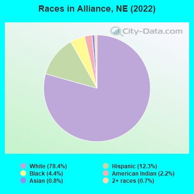
- 6,39078.4%White alone
- 1,00712.3%Hispanic
- 3574.4%Black alone
- 1782.2%American Indian alone
- 660.8%Asian alone
- 610.7%Two or more races
Races in Alliance detailed stats: ancestries, foreign born residents, place of birth
According to our research of Nebraska and other state lists, there were 27 registered sex offenders living in Alliance, Nebraska as of May 09, 2024.
The ratio of all residents to sex offenders in Alliance is 318 to 1.
The ratio of registered sex offenders to all residents in this city is near the state average.
Type |
2009 |
2010 |
2011 |
2013 |
2014 |
2015 |
2016 |
2017 |
2018 |
2019 |
2020 |
2021 |
2022 |
|---|---|---|---|---|---|---|---|---|---|---|---|---|---|
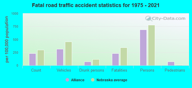
| Murders (per 100,000) | 0 (0.0) | 0 (0.0) | 1 (11.7) | 0 (0.0) | 0 (0.0) | 0 (0.0) | 0 (0.0) | 0 (0.0) | 0 (0.0) | 0 (0.0) | 1 (12.4) | 0 (0.0) | 0 (0.0) |
| Rapes (per 100,000) | 0 (0.0) | 0 (0.0) | 0 (0.0) | 8 (94.0) | 6 (70.6) | 3 (35.2) | 6 (70.3) | 9 (107.2) | 3 (36.9) | 6 (74.8) | 4 (49.7) | 11 (137.7) | 4 (51.2) |
| Robberies (per 100,000) | 5 (62.3) | 1 (11.8) | 2 (23.3) | 1 (11.8) | 2 (23.5) | 0 (0.0) | 1 (11.7) | 1 (11.9) | 0 (0.0) | 2 (24.9) | 2 (24.8) | 9 (112.7) | 1 (12.8) |
| Assaults (per 100,000) | 21 (261.7) | 15 (176.7) | 22 (256.8) | 11 (129.3) | 18 (211.7) | 8 (93.8) | 15 (175.8) | 13 (154.9) | 6 (73.9) | 4 (49.9) | 19 (236.0) | 37 (463.3) | 32 (409.9) |
| Burglaries (per 100,000) | 24 (299.1) | 31 (365.1) | 53 (618.7) | 57 (669.8) | 44 (517.5) | 32 (375.2) | 32 (375.0) | 31 (369.4) | 32 (394.0) | 33 (411.4) | 33 (409.9) | 234 (2,930) | 17 (217.8) |
| Thefts (per 100,000) | 114 (1,421) | 114 (1,343) | 106 (1,237) | 76 (893.1) | 122 (1,435) | 138 (1,618) | 61 (714.9) | 90 (1,072) | 90 (1,108) | 66 (822.7) | 52 (645.9) | 77 (964.2) | 105 (1,345) |
| Auto thefts (per 100,000) | 8 (99.7) | 9 (106.0) | 6 (70.0) | 3 (35.3) | 10 (117.6) | 1 (11.7) | 8 (93.8) | 9 (107.2) | 8 (98.5) | 9 (112.2) | 7 (86.9) | 13 (162.8) | 9 (115.3) |
| Arson (per 100,000) | 1 (12.5) | 0 (0.0) | 1 (11.7) | 1 (11.8) | 0 (0.0) | 1 (11.7) | 0 (0.0) | 0 (0.0) | 0 (0.0) | 1 (12.5) | 3 (37.3) | 0 (0.0) | 1 (12.8) |
| City-Data.com crime index | 156.8 | 126.6 | 180.1 | 190.0 | 208.9 | 138.8 | 157.3 | 197.7 | 124.1 | 148.0 | 180.7 | 493.4 | 205.1 |
The City-Data.com crime index weighs serious crimes and violent crimes more heavily. Higher means more crime, U.S. average is 246.1. It adjusts for the number of visitors and daily workers commuting into cities.
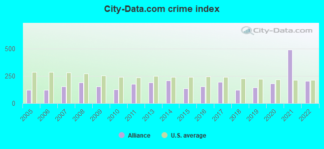
Crime rate in Alliance detailed stats: murders, rapes, robberies, assaults, burglaries, thefts, arson
Full-time law enforcement employees in 2021, including police officers: 23 (14 officers - 12 male; 2 female).
| Officers per 1,000 residents here: | 1.75 |
| US average: | 2.38 |
 Recent articles from our blog. Our writers, many of them Ph.D. graduates or candidates, create easy-to-read articles on a wide variety of topics.


 | Kearney or Alliance - please help! (16 replies) |
| I seen a list of the most boring stares Nebraska was included (24 replies) |
| Historic Omaha question (1 reply) |
| ~ NEW POST in the Nebraska City-Data Forums' sub-forum ~ (30 replies) |
| New Dollar Generals in Small Towns (11 replies) |
| Made/Invented in Nebraska (46 replies) |
Latest news from Alliance, NE collected exclusively by city-data.com from local newspapers, TV, and radio stations
Ancestries: German (24.7%), Bahamian (10.6%), Irish (5.5%), English (5.0%), Norwegian (4.2%), American (2.7%).
Current Local Time: MST time zone
Incorporated in 1888
Elevation: 3960 feet
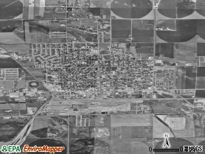
Land area: 4.77 square miles.
Population density: 1,686 people per square mile (low).

535 residents are foreign born (4.8% Latin America, 0.8% Asia).
| This city: | 6.6% |
| Nebraska: | 7.5% |
Median real estate property taxes paid for housing units with mortgages in 2022: $2,644 (1.4%)
Median real estate property taxes paid for housing units with no mortgage in 2022: $2,257 (1.6%)
Nearest city with pop. 50,000+: Cheyenne, WY  (119.8 miles , pop. 53,011).
Nearest city with pop. 200,000+: West Adams, CO (189.7 miles , pop. 259,628).
Nearest city with pop. 1,000,000+: Dallas, TX (724.4 miles , pop. 1,188,580).
Nearest cities:
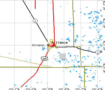
), Latitude: 42.10 N, Longitude: 102.87 W
Daytime population change due to commuting: +456 (+5.6%)
Workers who live and work in this city: 3,063 (81.3%)
Area code: 308

Alliance tourist attractions:
Alliance, Nebraska accommodation & food services, waste management - Economy and Business Data
Single-family new house construction building permits:
- 2019: 2 buildings, average cost: $305,000
- 2018: 2 buildings, average cost: $175,000
- 2016: 3 buildings, average cost: $310,000
- 2015: 6 buildings, average cost: $182,700
- 2014: 1 building, cost: $750,000
- 2013: 2 buildings, average cost: $144,500
- 2012: 3 buildings, average cost: $327,300
- 2010: 18 buildings, average cost: $122,200
- 2009: 2 buildings, average cost: $195,000
- 2008: 25 buildings, average cost: $144,800
- 2007: 4 buildings, average cost: $244,900
- 2006: 3 buildings, average cost: $111,400
- 2005: 2 buildings, average cost: $176,500
- 2004: 1 building, cost: $65,000
- 2003: 4 buildings, average cost: $116,600
- 2002: 5 buildings, average cost: $97,600
- 2001: 9 buildings, average cost: $100,100
- 2000: 2 buildings, average cost: $76,800
- 1999: 2 buildings, average cost: $115,000
- 1998: 15 buildings, average cost: $100,100
- 1997: 17 buildings, average cost: $80,900
| Here: | 2.2% |
| Nebraska: | 2.2% |
- Rail transportation (21.2%)
- Accommodation & food services (7.1%)
- Educational services (7.1%)
- Plastics & rubber products (6.3%)
- Health care (6.2%)
- Agriculture, forestry, fishing & hunting (5.2%)
- Public administration (3.9%)
- Rail transportation (32.9%)
- Agriculture, forestry, fishing & hunting (8.7%)
- Plastics & rubber products (6.8%)
- Construction (6.3%)
- Accommodation & food services (4.5%)
- Educational services (3.4%)
- Other transportation, support activities, couriers (2.7%)
- Health care (13.3%)
- Educational services (11.4%)
- Accommodation & food services (10.1%)
- Rail transportation (7.2%)
- Public administration (6.6%)
- Plastics & rubber products (5.6%)
- Social assistance (5.5%)
- Rail and water transportation workers (11.1%)
- Vehicle and mobile equipment mechanics, installers, and repairers (5.4%)
- Other production occupations, including supervisors (4.5%)
- Driver/sales workers and truck drivers (3.4%)
- Preschool, kindergarten, elementary, and middle school teachers (3.3%)
- Other sales and related occupations, including supervisors (3.1%)
- Other office and administrative support workers, including supervisors (3.1%)
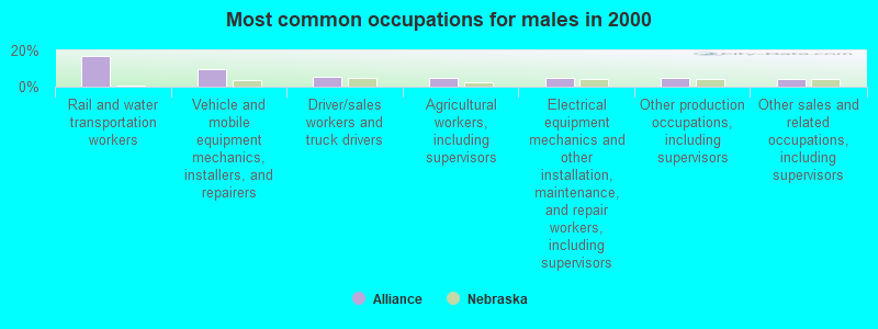
- Rail and water transportation workers (16.9%)
- Vehicle and mobile equipment mechanics, installers, and repairers (9.6%)
- Driver/sales workers and truck drivers (5.4%)
- Agricultural workers, including supervisors (4.9%)
- Electrical equipment mechanics and other installation, maintenance, and repair workers, including supervisors (4.8%)
- Other production occupations, including supervisors (4.7%)
- Other sales and related occupations, including supervisors (4.0%)
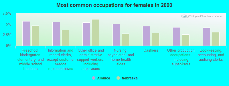
- Preschool, kindergarten, elementary, and middle school teachers (5.6%)
- Information and record clerks, except customer service representatives (5.5%)
- Other office and administrative support workers, including supervisors (5.4%)
- Nursing, psychiatric, and home health aides (5.0%)
- Cashiers (4.5%)
- Other production occupations, including supervisors (4.2%)
- Bookkeeping, accounting, and auditing clerks (4.2%)
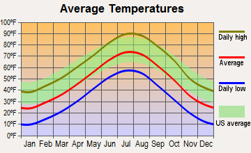
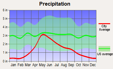
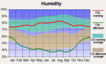
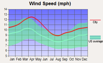
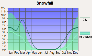
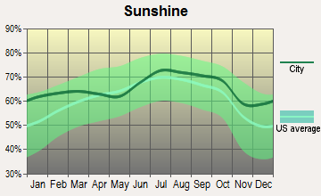
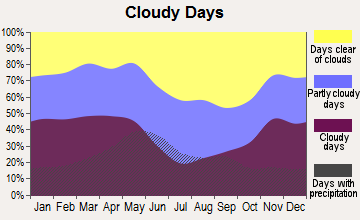
Average climate in Alliance, Nebraska
Based on data reported by over 4,000 weather stations
|
|

Tornado activity:
Alliance-area historical tornado activity is significantly below Nebraska state average. It is 30% smaller than the overall U.S. average.
On 6/27/1955, a category F4 (max. wind speeds 207-260 mph) tornado 32.6 miles away from the Alliance city center killed 2 people and injured 29 people and caused between $50,000 and $500,000 in damages.
On 5/5/1993, a category F3 (max. wind speeds 158-206 mph) tornado 27.9 miles away from the city center caused between $500,000 and $5,000,000 in damages.
Earthquake activity:
Alliance-area historical earthquake activity is significantly above Nebraska state average. It is 443% greater than the overall U.S. average.On 8/18/1959 at 06:37:13, a magnitude 7.7 (7.7 UK, Class: Major, Intensity: VIII - XII) earthquake occurred 426.9 miles away from the city center, causing $26,000,000 total damage
On 10/18/1984 at 15:30:23, a magnitude 5.5 (5.4 MB, 5.1 MS, 5.5 ML, Class: Moderate, Intensity: VI - VII) earthquake occurred 139.6 miles away from Alliance center
On 10/28/1983 at 14:06:06, a magnitude 7.3 (6.2 MB, 7.3 MS, 7.0 MW) earthquake occurred 568.4 miles away from the city center, causing 2 deaths (2 shaking deaths) and 3 injuries, causing $15,000,000 total damage
On 9/8/1984 at 00:59:31, a magnitude 5.1 (5.1 MB) earthquake occurred 213.1 miles away from the city center
On 5/29/1984 at 20:18:32, a magnitude 5.0 (5.0 MB) earthquake occurred 214.7 miles away from Alliance center
On 6/30/1975 at 18:54:13, a magnitude 6.1 (5.6 MB, 5.9 MS, 6.1 UK, 6.1 ML, Class: Strong, Intensity: VII - IX) earthquake occurred 433.3 miles away from the city center
Magnitude types: body-wave magnitude (MB), local magnitude (ML), surface-wave magnitude (MS), moment magnitude (MW)
Natural disasters:
The number of natural disasters in Box Butte County (7) is smaller than the US average (15).Major Disasters (Presidential) Declared: 3
Emergencies Declared: 1
Causes of natural disasters: Storms: 4, Floods: 3, Tornadoes: 3, Winds: 3, Hurricane: 1, Winter Storm: 1, Other: 1 (Note: some incidents may be assigned to more than one category).

Hospitals and medical centers in Alliance:
Airports and heliports located in Alliance:
- Alliance Municipal Airport (AIA) (Runways: 3, Commercial Ops: 516, Air Taxi Ops: 120, Itinerant Ops: 4,090, Local Ops: 7,850, Military Ops: 3)
- Box Butte General Hospital Med-I-Port Heliport (NE32)
Colleges/universities with over 2000 students nearest to Alliance:
- Chadron State College (about 51 miles; Chadron, NE; Full-time enrollment: 2,374)
- Laramie County Community College (about 121 miles; Cheyenne, WY; FT enrollment: 3,288)
- South Dakota School of Mines and Technology (about 138 miles; Rapid City, SD; FT enrollment: 2,102)
- University of Wyoming (about 150 miles; Laramie, WY; FT enrollment: 10,810)
- Wyotech-Laramie (about 150 miles; Laramie, WY; FT enrollment: 2,765)
- University of Northern Colorado (about 152 miles; Greeley, CO; FT enrollment: 11,469)
- Aims Community College (about 153 miles; Greeley, CO; FT enrollment: 3,598)
Public high school in Alliance:
- ALLIANCE HIGH SCHOOL (Students: 591, Location: 1450 BOX BUTTE, Grades: 9-12)
Public elementary/middle schools in Alliance:
- GRANDVIEW ELEMENTARY SCHOOL (Students: 266, Location: 615 GRAND, Grades: 2-4)
- EMERSON ELEMENTARY SCHOOL (Students: 241, Location: 700 BLACK HILLS, Grades: PK-2)
- ALLIANCE MIDDLE SCHOOL (Location: 11TH AND LARAMIE, Grades: 5-8)
Private elementary/middle school in Alliance:
Library in Alliance:
Points of interest:
Notable locations in Alliance: Jensens Wheel In Camper Court (A), Sunset Motel and RV Park (B), Alliance (C), Kelley Bean Company Incorporated Elevator (D), Sallows Arboretum and Conservatory (E), Alliance Speedway (F), Sandhills Drive-In Theater (G), Alliance Police Department (H), Alliance Fire Department (I), Box Butte County Courthouse (J), Box Butte County Sheriffs Office (K), Knight Museum of the High Plains Heritage (L), Alliance Public Library (M). Display/hide their locations on the map
Churches in Alliance include: Alliance Berean Church (A), Presbyterian Church (B), Spanish Assembly of God Church (C), The Church of Jesus Christ of Latter Day Saints (D), Episcopal Evangelical Free Church (E), Alliance Christian Church (F), Alliance Baptist Church (G), Panhandle Church of Christ (H), Calvary Assembly of God Church (I). Display/hide their locations on the map
Parks in Alliance include: Sudman Field (1), Knight Park (2), Bulldog Stadium (3), Laing Park (4), Central Park (5), Hal Murray Softball Complex (6), Bower Park (7), Bower-Shankland Field (8), Burlington Locomotive 719 Historical Marker (9). Display/hide their locations on the map
Tourist attraction: Alliance City - Knight Museum (908 Yellowstone Avenue).
Hotels: Super 8 Motel (West Highway 2), McCarrollS Motel (Bv) (1028 E 3rd St), U S Contract (2917 West Lakefield Drive), Days Inn of Alliance (117 Cody Avenue), Rainbow Lodge (614 West 3rd Street), Sunset Motel & RV Park (1210 East US Highway 2), Days Inn Alliance (117 Cody Avenue), West Way Motel & Restaurant (1207 West 3rd Street).
Courts: Box Butte County - Alliance- District Court Clerk (510 Box Butte Avenue), Box Butte County - Alliance- District Court Reporter (510 Box Butte Avenue).
Birthplace of: James Emanuel - Poet and scholar, Ronald L. Coker - Marine Corps Medal of Honor recipient, Chuck Hayward - Stunt performer, LeRoy J. Louden - Politician, Mike Gloor - Politician, Tony Wilbrand - College basketball player (Nebraska Cornhuskers).
Drinking water stations with addresses in Alliance and their reported violations in the past:
ALLIANCE, CITY OF (Population served: 8,500, Groundwater):Past health violations:FRONTIER MART (Serves WY, Population served: 140, Groundwater):
- MCL, Average - Between OCT-2012 and DEC-2012, Contaminant: Arsenic. Follow-up actions: St Public Notif received (DEC-06-2012), St Public Notif requested (DEC-07-2012), St Violation/Reminder Notice (DEC-07-2012), St Compliance achieved (NOV-22-2013)
- MCL, Average - Between OCT-2009 and DEC-2009, Contaminant: Arsenic. Follow-up actions: St Public Notif requested (DEC-18-2009), St Violation/Reminder Notice (DEC-18-2009), St Public Notif received (DEC-24-2009), St Compliance achieved (JUL-01-2010)
- MCL, Average - Between JUL-2009 and SEP-2009, Contaminant: Arsenic. Follow-up actions: St Public Notif requested (SEP-11-2009), St Violation/Reminder Notice (SEP-11-2009), St Public Notif received (SEP-24-2009), St Compliance achieved (JUL-01-2010)
- MCL, Average - Between APR-2009 and JUN-2009, Contaminant: Arsenic. Follow-up actions: St Public Notif requested (JUN-11-2009), St Violation/Reminder Notice (JUN-11-2009), St Public Notif received (JUN-22-2009), St Compliance achieved (JUL-01-2010)
- MCL, Monthly (TCR) - In NOV-2008, Contaminant: Coliform. Follow-up actions: St Public Notif requested (NOV-17-2008), St Violation/Reminder Notice (NOV-17-2008), St Public Notif received (DEC-01-2008)
- MCL, Acute (TCR) - In NOV-2008, Contaminant: Coliform. Follow-up actions: St Public Notif requested (NOV-17-2008), St Violation/Reminder Notice (NOV-17-2008), St Public Notif received (DEC-01-2008)
- 4 other older health violations
Past health violations:
- MCL, Average - Between APR-2014 and JUN-2014, Contaminant: Nitrate-Nitrite. Follow-up actions: Fed FAO issued (SEP-05-2014)
| This city: | 2.3 people |
| Nebraska: | 2.5 people |
| This city: | 64.0% |
| Whole state: | 64.8% |
| This city: | 5.4% |
| Whole state: | 6.0% |
Likely homosexual households (counted as self-reported same-sex unmarried-partner households)
- Lesbian couples: 0.2% of all households
- Gay men: 0.2% of all households
People in group quarters in Alliance in 2010:
- 117 people in nursing facilities/skilled-nursing facilities
- 19 people in other noninstitutional facilities
- 11 people in local jails and other municipal confinement facilities
- 8 people in group homes intended for adults
- 3 people in residential treatment centers for adults
People in group quarters in Alliance in 2000:
- 134 people in nursing homes
- 15 people in religious group quarters
- 14 people in local jails and other confinement facilities (including police lockups)
- 10 people in other noninstitutional group quarters
- 4 people in homes or halfway houses for drug/alcohol abuse
- 4 people in homes for the mentally retarded
Banks with branches in Alliance (2011 data):
- Bank of the West: Alliance Branch at 224 Box Butte Avenue, branch established on 1919/07/14; Alliance Drive Up Branch at 120 West 2nd Street, branch established on 1964/02/03. Info updated 2009/11/16: Bank assets: $62,408.3 mil, Deposits: $43,995.2 mil, headquarters in San Francisco, CA, positive income, 647 total offices, Holding Company: Bnp Paribas
- Wells Fargo Bank, National Association: Alliance Branch at 1204 West Third Street, branch established on 1979/01/25. Info updated 2011/04/05: Bank assets: $1,161,490.0 mil, Deposits: $905,653.0 mil, headquarters in Sioux Falls, SD, positive income, 6395 total offices, Holding Company: Wells Fargo & Company
- First National Bank: Alliance Branch at 124 West Third Street, branch established on 1888/04/01. Info updated 2006/11/03: Bank assets: $433.4 mil, Deposits: $382.5 mil, headquarters in North Platte, NE, positive income, Agricultural Specialization, 5 total offices, Holding Company: Lauritzen Corporation
- Great Western Bank: Alliance Office at 423 West 3rd Street, branch established on 1907/01/01. Info updated 2010/06/08: Bank assets: $8,458.0 mil, Deposits: $6,362.5 mil, headquarters in Watertown, SD, positive income, Commercial Lending Specialization, 187 total offices, Holding Company: National Australia Bank Limited
For population 15 years and over in Alliance:
- Never married: 25.0%
- Now married: 49.3%
- Separated: 0.9%
- Widowed: 9.7%
- Divorced: 15.1%
For population 25 years and over in Alliance:
- High school or higher: 91.6%
- Bachelor's degree or higher: 19.0%
- Graduate or professional degree: 2.7%
- Unemployed: 5.4%
- Mean travel time to work (commute): 11.1 minutes
| Here: | 8.2 |
| Nebraska average: | 11.2 |
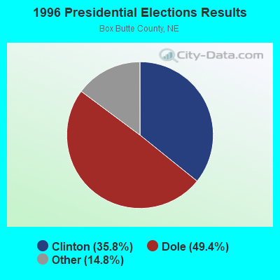
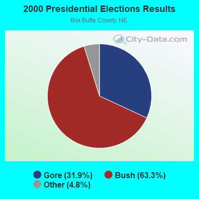
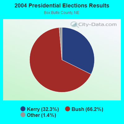
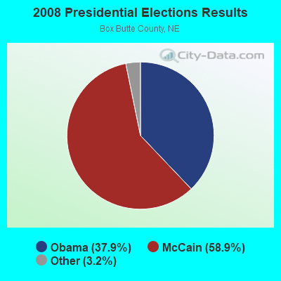
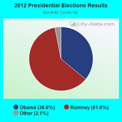
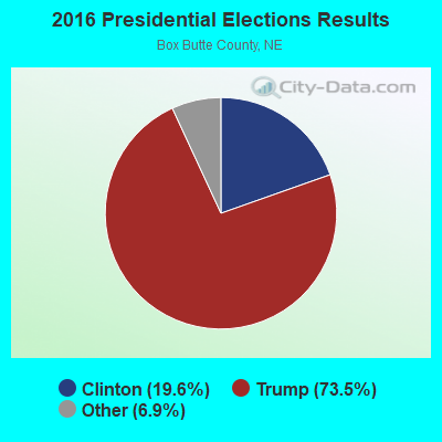
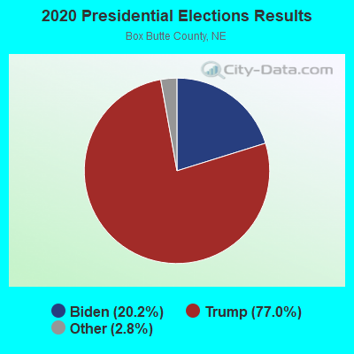
Graphs represent county-level data. Detailed 2008 Election Results
Religion statistics for Alliance, NE (based on Box Butte County data)
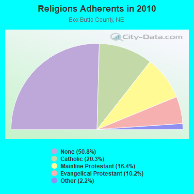
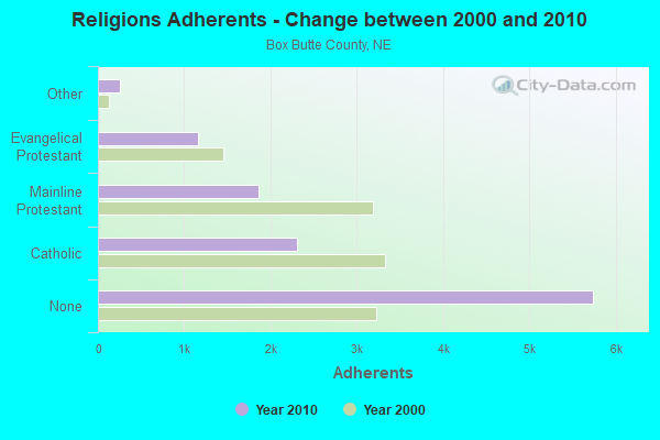
| Religion | Adherents | Congregations |
|---|---|---|
| Catholic | 2,301 | 2 |
| Mainline Protestant | 1,859 | 9 |
| Evangelical Protestant | 1,156 | 9 |
| Other | 252 | 2 |
| None | 5,740 | - |
Food Environment Statistics:
| Box Butte County: | 4.56 / 10,000 pop. |
| Nebraska: | 2.60 / 10,000 pop. |
| Box Butte County: | 5.47 / 10,000 pop. |
| State: | 4.83 / 10,000 pop. |
| Here: | 13.67 / 10,000 pop. |
| State: | 7.76 / 10,000 pop. |
| This county: | 8.5% |
| Nebraska: | 7.9% |
| Box Butte County: | 30.5% |
| Nebraska: | 28.0% |
| This county: | 13.4% |
| State: | 12.9% |
Health and Nutrition:
| Alliance: | 48.0% |
| Nebraska: | 48.9% |
| Here: | 43.9% |
| Nebraska: | 45.5% |
| Alliance: | 28.8 |
| Nebraska: | 28.6 |
| This city: | 23.4% |
| State: | 21.4% |
| Alliance: | 10.7% |
| Nebraska: | 10.5% |
| This city: | 6.8 |
| Nebraska: | 6.8 |
| This city: | 34.7% |
| Nebraska: | 33.5% |
| This city: | 53.5% |
| Nebraska: | 55.6% |
| Alliance: | 77.2% |
| Nebraska: | 78.2% |
More about Health and Nutrition of Alliance, NE Residents
| Local government employment and payroll (March 2022) | |||||
| Function | Full-time employees | Monthly full-time payroll | Average yearly full-time wage | Part-time employees | Monthly part-time payroll |
|---|---|---|---|---|---|
| Police Protection - Officers | 14 | $79,198 | $67,884 | 0 | $0 |
| Other Government Administration | 11 | $36,838 | $40,187 | 0 | $0 |
| Parks and Recreation | 11 | $47,833 | $52,181 | 6 | $5,855 |
| Electric Power | 8 | $51,090 | $76,635 | 3 | $1,327 |
| Financial Administration | 7 | $26,760 | $45,874 | 1 | $1,364 |
| Police - Other | 7 | $20,059 | $34,387 | 0 | $0 |
| Solid Waste Management | 6 | $21,109 | $42,218 | 0 | $0 |
| Other and Unallocable | 5 | $18,988 | $45,571 | 0 | $0 |
| Water Supply | 5 | $25,349 | $60,838 | 4 | $6,957 |
| Streets and Highways | 4 | $15,409 | $46,227 | 0 | $0 |
| Transit | 4 | $11,796 | $35,388 | 3 | $3,082 |
| Local Libraries | 3 | $13,000 | $52,000 | 7 | $5,024 |
| Firefighters | 2 | $15,686 | $94,116 | 0 | $0 |
| Airports | 2 | $13,233 | $79,398 | 1 | $157 |
| Fire - Other | 2 | $10,272 | $61,632 | 0 | $0 |
| Health | 1 | $3,771 | $45,252 | 0 | $0 |
| Welfare | 1 | $3,751 | $45,012 | 1 | $1,284 |
| Sewerage | 1 | $4,389 | $52,668 | 0 | $0 |
| Totals for Government | 94 | $418,530 | $53,429 | 26 | $25,051 |
Alliance government finances - Expenditure in 2021 (per resident):
- Construction - Air Transportation: $5,485,000 ($682.47)
Regular Highways: $3,905,000 ($485.88)
Electric Utilities: $3,500,000 ($435.49)
Parks and Recreation: $904,000 ($112.48)
Libraries: $301,000 ($37.45)
Water Utilities: $200,000 ($24.88)
Solid Waste Management: $170,000 ($21.15)
Central Staff Services: $62,000 ($7.71)
Financial Administration: $47,000 ($5.85)
Housing and Community Development: $28,000 ($3.48)
Police Protection: $17,000 ($2.12)
Local Fire Protection: $11,000 ($1.37)
General Public Buildings: $9,000 ($1.12)
- Current Operations - Electric Utilities: $11,154,000 ($1387.83)
Housing and Community Development: $1,996,000 ($248.35)
Parks and Recreation: $1,938,000 ($241.13)
General - Other: $1,932,000 ($240.39)
Police Protection: $1,708,000 ($212.52)
Central Staff Services: $1,246,000 ($155.03)
Water Utilities: $1,169,000 ($145.45)
Regular Highways: $1,167,000 ($145.20)
Local Fire Protection: $1,092,000 ($135.87)
Financial Administration: $958,000 ($119.20)
Solid Waste Management: $937,000 ($116.59)
Libraries: $646,000 ($80.38)
Air Transportation: $452,000 ($56.24)
Sewerage: $423,000 ($52.63)
Transit Utilities: $345,000 ($42.93)
Protective Inspection and Regulation - Other: $339,000 ($42.18)
General Public Buildings: $192,000 ($23.89)
- General - Interest on Debt: $18,000 ($2.24)
- Other Capital Outlay - Protective Inspection and Regulation - Other: $1,525,000 ($189.75)
Sewerage: $700,000 ($87.10)
Solid Waste Management: $545,000 ($67.81)
Electric Utilities: $530,000 ($65.95)
Water Utilities: $475,000 ($59.10)
Police Protection: $128,000 ($15.93)
Local Fire Protection: $82,000 ($10.20)
Regular Highways: $80,000 ($9.95)
Parks and Recreation: $78,000 ($9.71)
Central Staff Services: $48,000 ($5.97)
Financial Administration: $37,000 ($4.60)
Air Transportation: $30,000 ($3.73)
Libraries: $26,000 ($3.24)
General Public Building: $7,000 ($0.87)
- Total Salaries and Wages: $13,015,000 ($1619.39)
Alliance government finances - Revenue in 2021 (per resident):
- Charges - Sewerage: $706,000 ($87.84)
Solid Waste Management: $703,000 ($87.47)
Parks and Recreation: $426,000 ($53.00)
Air Transportation: $244,000 ($30.36)
- Federal Intergovernmental - Other: $7,305,000 ($908.92)
- Local Intergovernmental - General Local Government Support: $2,000 ($0.25)
- Miscellaneous - General Revenue - Other: $3,484,000 ($433.50)
Interest Earnings: $342,000 ($42.55)
- Revenue - Electric Utilities: $14,946,000 ($1859.65)
Water Utilities: $1,753,000 ($218.12)
Transit Utilities: $59,000 ($7.34)
- State Intergovernmental - Highways: $946,000 ($117.71)
General Local Government Support: $429,000 ($53.38)
Other: $275,000 ($34.22)
- Tax - Other License: $5,093,000 ($633.69)
General Sales and Gross Receipts: $2,000,000 ($248.85)
Property: $1,858,000 ($231.18)
Public Utilities Sales: $1,340,000 ($166.73)
Alliance government finances - Debt in 2021 (per resident):
- Long Term Debt - Beginning Outstanding - Unspecified Public Purpose: $438,000 ($54.50)
Outstanding Unspecified Public Purpose: $438,000 ($54.50)
Retired Unspecified Public Purpose: $438,000 ($54.50)
Issue, Unspecified Public Purpose: $438,000 ($54.50)
Alliance government finances - Cash and Securities in 2021 (per resident):
- Other Funds - Cash and Securities: $17,123,000 ($2130.52)
| Businesses in Alliance, NE | ||||
| Name | Count | Name | Count | |
|---|---|---|---|---|
| Arby's | 1 | MasterBrand Cabinets | 1 | |
| Dairy Queen | 1 | McDonald's | 1 | |
| FedEx | 1 | Pizza Hut | 1 | |
| Ford | 1 | RadioShack | 1 | |
| H&R Block | 1 | Safeway | 1 | |
| Holiday Inn | 1 | U-Haul | 1 | |
| Kmart | 1 | UPS | 2 | |
| La-Z-Boy | 1 | Vons | 1 | |
| Lane Furniture | 1 | YMCA | 1 | |
Strongest AM radio stations in Alliance:
- KCOW (1400 AM; 1 kW; ALLIANCE, NE; Owner: EAGLE RADIO, INC.)
- KIMB (1260 AM; 50 kW; KIMBALL, NE; Owner: G & L INVESTMENTS, LLC)
- KNEB (960 AM; 5 kW; SCOTTSBLUFF, NE; Owner: PANHANDLE BROADCASTING, INC.)
- KLTT (670 AM; 50 kW; COMMERCE CITY, CO; Owner: KLZ RADIO, INC.)
- KKZN (760 AM; 50 kW; THORNTON, CO; Owner: JACOR BROADCASTING OF COLORADO, INC.)
- KOLT (1320 AM; 5 kW; SCOTTSBLUFF, NE; Owner: TRACY BROADCASTING CORP.)
- KTWO (1030 AM; 50 kW; CASPER, WY; Owner: CITICASTERS LICENSES, L.P.)
- KSIR (1010 AM; 25 kW; BRUSH, CO; Owner: JMS BROADCASTING, LLC)
- KOA (850 AM; 50 kW; DENVER, CO; Owner: JACOR BROADCASTING OF COLORADO, INC.)
- KRVN (880 AM; 50 kW; LEXINGTON, NE; Owner: NEBRASKA RURAL RADIO ASSOCIATION)
- KMXA (1090 AM; 50 kW; AURORA, CO; Owner: ENTRAVISION HOLDINGS, LLC)
- KBHB (810 AM; 25 kW; STURGIS, SD; Owner: MONTEREY LICENSES, LLC)
- KUYO (830 AM; daytime; 25 kW; EVANSVILLE, WY; Owner: WYOMING CHRISTIAN BROADCASTING COMPANY)
Strongest FM radio stations in Alliance:
- K296DS (107.1 FM; ALLIANCE, NE; Owner: JAMES AND SUSAN NOGA)
- KTNE-FM (91.1 FM; ALLIANCE, NE; Owner: NEBRASKA EDUCATIONAL TELECOMMUNICATIONS COMM.)
- KPNY (102.1 FM; ALLIANCE, NE; Owner: HALSTEAD COMMUNICATIONS, INC.)
- KAAQ (105.9 FM; ALLIANCE, NE; Owner: EAGLE RADIO, INC.)
- KQSK (97.5 FM; CHADRON, NE; Owner: EAGLE RADIO, INC.)
TV broadcast stations around Alliance:
- K23EU (Channel 31; COLUMBUS, ETC, NE; Owner: DAVID C. BROADAHL)
- K33EM (Channel 33; COLUMBUS, ETC., NE; Owner: DAVID C. BRODAHL)
- K65GE (Channel 65; COLUMBUS-FREMONT, NE; Owner: ROGER E. HARDERS)
- KDUH-TV (Channel 4; SCOTTSBLUFF, NE; Owner: DUHAMEL BROADCASTING ENTERPRISES)
- KTNE-TV (Channel 13; ALLIANCE, NE; Owner: NEBRASKA EDUCATIONAL TELECOMMUNICATIONS COMM.)
Medal of Honor Recipients
Medal of Honor Recipient born in Alliance: Ronald L. Coker.
- National Bridge Inventory (NBI) Statistics
- 10Number of bridges
- 72ft / 22.1mTotal length
- 29,805Total average daily traffic
- 1,790Total average daily truck traffic
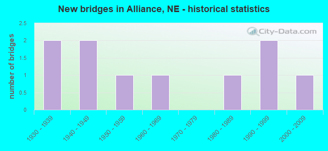
- New bridges - historical statistics
- 21930-1939
- 21940-1949
- 11950-1959
- 11960-1969
- 11980-1989
- 21990-1999
- 12000-2009
FCC Registered Antenna Towers: 87 (See the full list of FCC Registered Antenna Towers)
FCC Registered Commercial Land Mobile Towers: 1 (See the full list of FCC Registered Commercial Land Mobile Towers in Alliance, NE)
FCC Registered Private Land Mobile Towers: 2 (See the full list of FCC Registered Private Land Mobile Towers)
FCC Registered Broadcast Land Mobile Towers: 43 (See the full list of FCC Registered Broadcast Land Mobile Towers)
FCC Registered Microwave Towers: 40 (See the full list of FCC Registered Microwave Towers in this town)
FCC Registered Paging Towers: 4 (See the full list of FCC Registered Paging Towers)
FCC Registered Maritime Coast & Aviation Ground Towers: 5 (See the full list of FCC Registered Maritime Coast & Aviation Ground Towers)
FCC Registered Amateur Radio Licenses: 31 (See the full list of FCC Registered Amateur Radio Licenses in Alliance)
FAA Registered Aircraft Manufacturers and Dealers: 2 (See the full list of FAA Registered Manufacturers and Dealers in Alliance)
FAA Registered Aircraft: 44 (See the full list of FAA Registered Aircraft)
2002 - 2016 National Fire Incident Reporting System (NFIRS) incidents
- Fire incident types reported to NFIRS in Alliance, NE
- 28756.4%Outside Fires
- 14428.3%Structure Fires
- 7013.8%Mobile Property/Vehicle Fires
- 81.6%Other
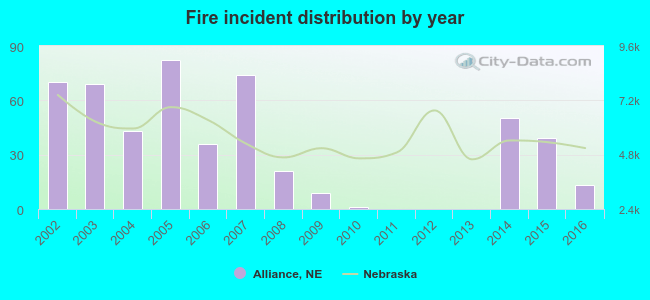 According to the data from the years 2002 - 2016 the average number of fires per year is 34. The highest number of reported fire incidents - 82 took place in 2005, and the least - 0 in 2011. The data has a dropping trend.
 When looking into fire subcategories, the most reports belonged to: Outside Fires (56.4%), and Structure Fires (28.3%).
Fire-safe hotels and motels in Alliance, Nebraska:
- Quality Inn, 1420 W 3RD St, Alliance, Nebraska 69301 , Phone: (308) 762-7600, Fax: (308) 762-6468
- Holiday Inn Express Alliance, 1630 Holsten Dr, Alliance, Nebraska 69301 , Phone: (308) 761-0970
| Most common first names in Alliance, NE among deceased individuals | ||
| Name | Count | Lived (average) |
|---|---|---|
| John | 79 | 78.0 years |
| William | 63 | 79.9 years |
| Mary | 59 | 81.8 years |
| Robert | 38 | 72.4 years |
| Helen | 37 | 85.3 years |
| Charles | 37 | 78.8 years |
| James | 36 | 73.9 years |
| George | 35 | 79.3 years |
| Margaret | 33 | 82.5 years |
| Anna | 31 | 85.7 years |
| Most common last names in Alliance, NE among deceased individuals | ||
| Last name | Count | Lived (average) |
|---|---|---|
| Johnson | 38 | 80.3 years |
| Smith | 24 | 82.2 years |
| Miller | 20 | 85.9 years |
| Hashman | 19 | 82.4 years |
| Jensen | 18 | 74.0 years |
| Mundt | 18 | 76.0 years |
| Walker | 17 | 81.6 years |
| Nelson | 16 | 82.3 years |
| Taylor | 15 | 78.3 years |
| Wright | 13 | 79.8 years |
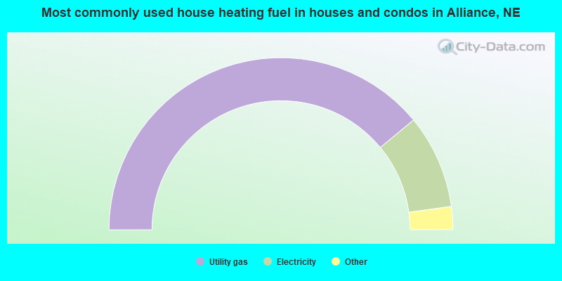
- 78.0%Utility gas
- 17.7%Electricity
- 2.1%Wood
- 1.8%Bottled, tank, or LP gas
- 0.4%No fuel used
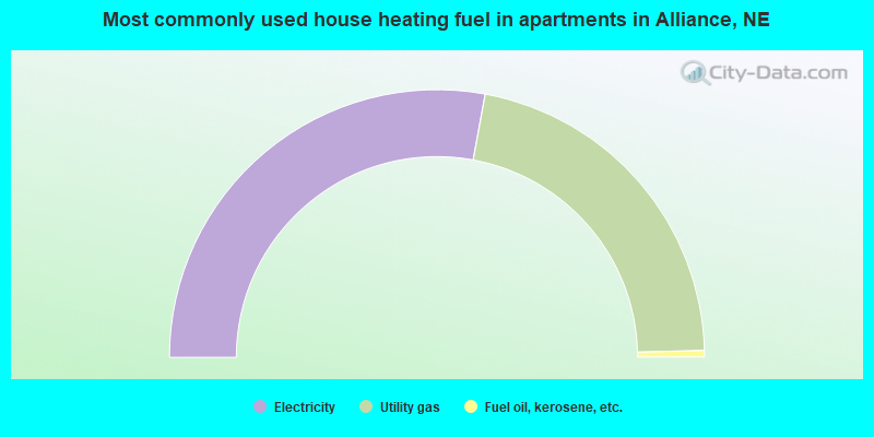
- 55.8%Electricity
- 43.4%Utility gas
- 0.8%Fuel oil, kerosene, etc.
Alliance compared to Nebraska state average:
- Unemployed percentage below state average.
- Number of college students significantly below state average.
Alliance on our top lists:
- #1 on the list of "Top 101 cities with largest percentage of males in industries: transportation and warehousing (population 5,000+)"
- #3 on the list of "Top 101 cities with largest percentage of males in occupations: transportation occupations (population 5,000+)"

|
Total of 4 patent applications in 2008-2024.