Bridge Statistics for Winston, Florida (FL)
Condition, Traffic, Stress, Structural Evaluation, Project Costs
- National Bridge Inventory (NBI) Statistics
- 32Number of bridges
- 302ft / 91.8mTotal length
- 874,526Total average daily traffic
- 129,404Total average daily truck traffic
- National Bridge Inventory (NBI) Registered Bridges for Winston
- No street view available for this location
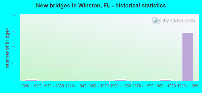
- New bridges - historical statistics
- 11920-1929
- 11960-1969
- 11980-1989
- 291990-1999


- Bridge Condition - Deck
- 93.8%Good
- 6.3%Satisfactory

- Bridge Condition - Superstructure
- 62.5%Very good
- 31.3%Good
- 6.3%Fair

- Bridge Condition - Substructure
- 12.5%Very good
- 81.3%Good
- 6.3%Satisfactory

- Bridge Condition - Channel
- 50.0%Good
- 50.0%Satisfactory
Find on map >> Show street view
Structure Number: 160026, Location: 1 MI E OF N GALLOWAY RD (Lat: 28.037403, Lng: -82.010153), Route carried "on" structure: US 92, Year Built: 1926, Year Reconstructed: 1945, Status: Open, Structure Length: 1.41m (4.63ft), Average Daily Traffic: 17,300 (year 2020), Truck Traffic: 10%, Average Future Daily Traffic: 30,016 (year 2042), Design Load: H 15, Features Intersected: WINSTON CREEK
Minimum Vertical Clearance: 30+ m (98+ ft), Kilometerpoint: 4.619, Lanes on structure: 2, Base Highway Network: Yes, Owner: State Highway Agency, Approaching Roadway Width: 8.5m (27.9ft), Material/Design: Concrete, Design/Construction: Slab, Number Of Spans In Main Unit: 2, Length of Maximum Span: 7.0m (23.0ft), Curb-To-Curb Width: 9.1m (29.9ft), Out-to-Out Width: 10.7m (35.1ft)
Condition: Deck: Good, Superstructure: Good, Substructure: Good, Channel: Satisfactory, Operating Rating: 72.6 metric tons, Method Used To Determine Operating Rating: Load Factor (LF), Inventory Rating: 43.5 metric tons, Method Used To Determine Inventory Rating: Load Factor (LF), Structural Evaluation: Better than present minimum criteria, Deck Geometry: High priority of corrective action, Waterway Adequacy: Equal to present desirable criteria, Approach Roadway Alignment: Equal to present desirable criteria, Designated Inspection Frequency: Every 24 months, Underwater Inspection Frequency: Every 23 months, Inspection Date: September 2020, Underwater Inspection Date: September 2020, Deck Structure Type: Concrete Cast-file-Place, Wearing Surface/Protective System: Wearing Surface: Bituminous
Find on map >> Show street view
Structure Number: 160234, Location: I-4 WEST INTERCHANGE (Lat: 28.036758, Lng: -82.040203), Route carried "on" structure: State highway 570, Year Built: 1998, Status: Open, Structure Length: 9.66m (31.69ft), Average Daily Traffic: 14,800 (year 2020), Truck Traffic: 17%, Average Future Daily Traffic: 25,678 (year 2042), Design Load: HS 20+Mod, Features Intersected: I-4 SR 400
Minimum Vertical Clearance: 30+ m (98+ ft), Kilometerpoint: 0.000, Lanes on structure: 1, Lanes under structure: 7, Base Highway Network: Yes, Toll: On toll road, Owner: State Toll Authority, Approaching Roadway Width: 8.8m (28.9ft), Material/Design: Prestressed concrete, Design/Construction: Stringer/Multi-beam, Number Of Spans In Main Unit: 3, Length of Maximum Span: 42.2m (138.5ft), Curb-To-Curb Width: 8.3m (27.2ft), Out-to-Out Width: 9.3m (30.5ft)
Condition: Deck: Good, Superstructure: Very good, Substructure: Good, Operating Rating: 37.2 metric tons, Method Used To Determine Operating Rating: Load and Resistance Factor (LRFR), Inventory Rating: 28.7 metric tons, Method Used To Determine Inventory Rating: Load and Resistance Factor (LRFR), Structural Evaluation: Better than present minimum criteria, Deck Geometry: High priority of corrective action, Underclear: Equal to present minimum criteria, Approach Roadway Alignment: Equal to present minimum criteria, Designated Inspection Frequency: Every 24 months, Inspection Date: May 2020, Deck Structure Type: Concrete Cast-file-Place
Find on map >> Show street view
Structure Number: 160235, Location: I-4 WEST INTERCHANGE (Lat: 28.036686, Lng: -82.039983), Route carried "on" structure: State highway 570, Year Built: 1998, Status: Open, Structure Length: 9.64m (31.63ft), Average Daily Traffic: 14,800 (year 2020), Truck Traffic: 17%, Average Future Daily Traffic: 25,678 (year 2042), Design Load: HS 20+Mod, Features Intersected: I-4 SR 400
Minimum Vertical Clearance: 30+ m (98+ ft), Kilometerpoint: 0.000, Lanes on structure: 1, Lanes under structure: 7, Base Highway Network: Yes, Toll: On toll road, Owner: State Toll Authority, Approaching Roadway Width: 11.6m (38.1ft), Material/Design: Prestressed concrete, Design/Construction: Stringer/Multi-beam, Number Of Spans In Main Unit: 3, Length of Maximum Span: 42.2m (138.5ft), Curb-To-Curb Width: 12.2m (40.0ft), Out-to-Out Width: 13.2m (43.3ft)
Condition: Deck: Good, Superstructure: Very good, Substructure: Good, Operating Rating: 42.3 metric tons, Method Used To Determine Operating Rating: Load and Resistance Factor (LRFR), Inventory Rating: 34.2 metric tons, Method Used To Determine Inventory Rating: Load and Resistance Factor (LRFR), Structural Evaluation: Better than present minimum criteria, Deck Geometry: Somewhat better than minimum adequacy, Underclear: Equal to present minimum criteria, Approach Roadway Alignment: Somewhat better than minimum adequacy, Designated Inspection Frequency: Every 24 months, Inspection Date: May 2020, Deck Structure Type: Concrete Cast-file-Place
Find on map >> Show street view
Structure Number: 160236, Location: I-4 WEST INTERCHANGE (Lat: 28.036753, Lng: -82.039411), Route carried "on" structure: City street , Year Built: 1998, Status: Open, Structure Length: 9.65m (31.66ft), Average Daily Traffic: 7,000 (year 1998), Truck Traffic: 3%, Average Future Daily Traffic: 14,200 (year 2035), Design Load: HS 20+Mod, Features Intersected: I-4 SR 400, Facility Carried by Structure: CLARK ROAD 0.0
Minimum Vertical Clearance: 30+ m (98+ ft), Kilometerpoint: 0.000, Lanes on structure: 2, Lanes under structure: 7, Owner: State Toll Authority, Approaching Roadway Width: 13.4m (44.0ft), Material/Design: Prestressed concrete, Design/Construction: Stringer/Multi-beam, Number Of Spans In Main Unit: 3, Length of Maximum Span: 42.0m (137.8ft), Curb-To-Curb Width: 13.4m (44.0ft), Out-to-Out Width: 14.3m (46.9ft)
Condition: Deck: Good, Superstructure: Very good, Substructure: Good, Operating Rating: 41.2 metric tons, Method Used To Determine Operating Rating: Load and Resistance Factor (LRFR), Inventory Rating: 31.8 metric tons, Method Used To Determine Inventory Rating: Load and Resistance Factor (LRFR), Structural Evaluation: Better than present minimum criteria, Deck Geometry: Equal to present minimum criteria, Underclear: Equal to present minimum criteria, Approach Roadway Alignment: Equal to present desirable criteria, Designated Inspection Frequency: Every 24 months, Inspection Date: May 2020, Deck Structure Type: Concrete Cast-file-Place
Find on map >> Show street view
Structure Number: 160237, Location: RAMP I-4 EB TO SR 570 EB (Lat: 28.034981, Lng: -82.040906), Route carried "on" structure: Ramp State highway 570, Year Built: 1998, Status: Open, Structure Length: 2.67m (8.76ft), Average Daily Traffic: 8,100 (year 2020), Truck Traffic: 17%, Average Future Daily Traffic: 14,054 (year 2042), Design Load: HS 20+Mod, Features Intersected: SW FRONTAGE ROAD
Minimum Vertical Clearance: 30+ m (98+ ft), Kilometerpoint: 0.295, Lanes on structure: 2, Lanes under structure: 2, Toll: On toll road, Owner: State Toll Authority, Approaching Roadway Width: 13.8m (45.3ft), Skew: 3 degrees, Material/Design: Prestressed concrete, Design/Construction: Stringer/Multi-beam, Number Of Spans In Main Unit: 1, Length of Maximum Span: 26.7m (87.6ft), Curb-To-Curb Width: 13.1m (43.0ft), Out-to-Out Width: 14.1m (46.3ft)
Condition: Deck: Good, Superstructure: Very good, Substructure: Good, Operating Rating: 48.7 metric tons, Method Used To Determine Operating Rating: Load and Resistance Factor (LRFR), Inventory Rating: 37.6 metric tons, Method Used To Determine Inventory Rating: Load and Resistance Factor (LRFR), Structural Evaluation: Better than present minimum criteria, Deck Geometry: Superior to present desirable criteria, Underclear: Superior to present desirable criteria, Approach Roadway Alignment: Equal to present desirable criteria, Designated Inspection Frequency: Every 24 months, Inspection Date: May 2020, Deck Structure Type: Concrete Cast-file-Place
Find on map >> Show street view
Structure Number: 160238, Location: 0.1MI S OF I-4 WEST INT (Lat: 28.034967, Lng: -82.040211), Route carried "on" structure: State highway 570, Year Built: 1998, Status: Open, Structure Length: 2.48m (8.14ft), Average Daily Traffic: 14,800 (year 2020), Truck Traffic: 17%, Average Future Daily Traffic: 25,678 (year 2042), Design Load: HS 20, Features Intersected: SW FRONTAGE ROAD
Minimum Vertical Clearance: 30+ m (98+ ft), Kilometerpoint: 0.235, Lanes on structure: 1, Lanes under structure: 3, Base Highway Network: Yes, Toll: On toll road, Owner: State Toll Authority, Approaching Roadway Width: 8.2m (26.9ft), Material/Design: Prestressed concrete, Design/Construction: Stringer/Multi-beam, Number Of Spans In Main Unit: 1, Length of Maximum Span: 24.8m (81.4ft), Curb-To-Curb Width: 8.2m (26.9ft), Out-to-Out Width: 9.2m (30.2ft)
Condition: Deck: Good, Superstructure: Good, Substructure: Good, Operating Rating: 60.3 metric tons, Method Used To Determine Operating Rating: Load and Resistance Factor (LRFR), Inventory Rating: 46.5 metric tons, Method Used To Determine Inventory Rating: Load and Resistance Factor (LRFR), Structural Evaluation: Better than present minimum criteria, Deck Geometry: High priority of replacement, Underclear: Superior to present desirable criteria, Approach Roadway Alignment: Equal to present desirable criteria, Designated Inspection Frequency: Every 24 months, Inspection Date: May 2020, Deck Structure Type: Concrete Cast-file-Place
Find on map >> Show street view
Structure Number: 160239, Location: 0.1 MI S OF I-4 WEST INT (Lat: 28.034978, Lng: -82.039997), Route carried "on" structure: State highway 570, Year Built: 1998, Status: Open, Structure Length: 2.48m (8.14ft), Average Daily Traffic: 14,800 (year 2020), Truck Traffic: 17%, Average Future Daily Traffic: 25,678 (year 2042), Design Load: HS 20+Mod, Features Intersected: SW FRONTAGE RD
Minimum Vertical Clearance: 30+ m (98+ ft), Kilometerpoint: 0.235, Lanes on structure: 2, Lanes under structure: 3, Base Highway Network: Yes, Toll: On toll road, Owner: State Toll Authority, Approaching Roadway Width: 11.4m (37.4ft), Material/Design: Prestressed concrete, Design/Construction: Stringer/Multi-beam, Number Of Spans In Main Unit: 1, Length of Maximum Span: 24.8m (81.4ft), Curb-To-Curb Width: 12.2m (40.0ft), Out-to-Out Width: 13.2m (43.3ft)
Condition: Deck: Good, Superstructure: Very good, Substructure: Good, Operating Rating: 48.4 metric tons, Method Used To Determine Operating Rating: Load and Resistance Factor (LRFR), Inventory Rating: 37.9 metric tons, Method Used To Determine Inventory Rating: Load and Resistance Factor (LRFR), Structural Evaluation: Better than present minimum criteria, Deck Geometry: Better than present minimum criteria, Underclear: Superior to present desirable criteria, Approach Roadway Alignment: Equal to present desirable criteria, Designated Inspection Frequency: Every 24 months, Inspection Date: May 2020, Deck Structure Type: Concrete Cast-file-Place
Find on map >> Show street view
Structure Number: 16024, Location: RMP SR 570 WB TO I-4 EB W (Lat: 28.034922, Lng: -82.039419), Route carried "on" structure: Ramp State highway 570, Year Built: 1998, Status: Open, Structure Length: 15.15m (49.70ft), Average Daily Traffic: 4,600 (year 2020), Truck Traffic: 17%, Average Future Daily Traffic: 7,981 (year 2042), Design Load: HS 20+Mod, Features Intersected: CLARK ROAD
Minimum Vertical Clearance: 30+ m (98+ ft), Kilometerpoint: 0.048, Lanes on structure: 1, Lanes under structure: 3, Base Highway Network: Yes (Inventory Route: 164700, Subroute: 4), Toll: On toll road, Owner: State Toll Authority, Approaching Roadway Width: 8.8m (28.9ft), Skew: 9 degrees, Material/Design: Steel continuous, Design/Construction: Stringer/Multi-beam, Number Of Spans In Main Unit: 3, Length of Maximum Span: 65.2m (213.9ft), Curb-To-Curb Width: 9.4m (30.8ft), Out-to-Out Width: 10.4m (34.1ft)
Condition: Deck: Good, Superstructure: Good, Substructure: Good, Inventory Rating: 64.0 metric tons, Method Used To Determine Inventory Rating: Load Factor (LF), Structural Evaluation: Better than present minimum criteria, Deck Geometry: Superior to present desirable criteria, Underclear: Superior to present desirable criteria, Approach Roadway Alignment: Equal to present desirable criteria, Designated Inspection Frequency: Every 24 months, Inspection Date: May 2020, Deck Structure Type: Concrete Cast-file-Place
Find on map >> Show street view
Structure Number: 160241, Location: 0.3 MI S OF I-4 WEST INT (Lat: 28.031269, Lng: -82.040231), Route carried "on" structure: State highway 570, Year Built: 1998, Status: Open, Structure Length: 3.60m (11.81ft), Average Daily Traffic: 14,800 (year 2020), Truck Traffic: 17%, Average Future Daily Traffic: 25,678 (year 2042), Design Load: HS 20+Mod, Features Intersected: US 92 NEW TPA HWY
Minimum Vertical Clearance: 30+ m (98+ ft), Kilometerpoint: 0.647, Lanes on structure: 3, Lanes under structure: 3, Base Highway Network: Yes, Toll: On toll road, Owner: State Toll Authority, Approaching Roadway Width: 15.2m (49.9ft), Skew: 1 degrees, Material/Design: Prestressed concrete, Design/Construction: Stringer/Multi-beam, Number Of Spans In Main Unit: 1, Length of Maximum Span: 36.0m (118.1ft), Curb-To-Curb Width: 15.8m (51.8ft), Out-to-Out Width: 16.8m (55.1ft)
Condition: Deck: Good, Superstructure: Very good, Substructure: Very good, Operating Rating: 50.3 metric tons, Method Used To Determine Operating Rating: Load and Resistance Factor (LRFR), Inventory Rating: 43.7 metric tons, Method Used To Determine Inventory Rating: Load and Resistance Factor (LRFR), Structural Evaluation: Equal to present desirable criteria, Deck Geometry: Somewhat better than minimum adequacy, Underclear: Superior to present desirable criteria, Approach Roadway Alignment: Equal to present desirable criteria, Designated Inspection Frequency: Every 24 months, Inspection Date: May 2020, Deck Structure Type: Concrete Cast-file-Place
Find on map >> Show street view
Structure Number: 160242, Location: 0.3 MI S OF I-4 WEST INT (Lat: 28.031308, Lng: -82.039964), Route carried "on" structure: State highway 570, Year Built: 1998, Status: Open, Structure Length: 3.60m (11.81ft), Average Daily Traffic: 14,800 (year 2020), Truck Traffic: 17%, Average Future Daily Traffic: 25,678 (year 2042), Design Load: HS 20+Mod, Features Intersected: US 92 NEW TPA HWY
Minimum Vertical Clearance: 30+ m (98+ ft), Kilometerpoint: 0.637, Lanes on structure: 2, Lanes under structure: 3, Base Highway Network: Yes, Toll: On toll road, Owner: State Toll Authority, Approaching Roadway Width: 12.2m (40.0ft), Skew: 1 degrees, Material/Design: Prestressed concrete, Design/Construction: Stringer/Multi-beam, Number Of Spans In Main Unit: 1, Length of Maximum Span: 36.0m (118.1ft), Curb-To-Curb Width: 12.2m (40.0ft), Out-to-Out Width: 13.2m (43.3ft)
Condition: Deck: Good, Superstructure: Very good, Substructure: Very good, Operating Rating: 47.1 metric tons, Method Used To Determine Operating Rating: Load and Resistance Factor (LRFR), Inventory Rating: 43.1 metric tons, Method Used To Determine Inventory Rating: Load and Resistance Factor (LRFR), Structural Evaluation: Equal to present desirable criteria, Deck Geometry: Better than present minimum criteria, Underclear: Superior to present desirable criteria, Approach Roadway Alignment: Equal to present desirable criteria, Designated Inspection Frequency: Every 24 months, Inspection Date: May 2020, Deck Structure Type: Concrete Cast-file-Place
Find on map >> Show street view
Structure Number: 160243, Location: 0.4 MI S OF I-4 WEST INT (Lat: 28.029389, Lng: -82.040197), Route carried "on" structure: State highway 570, Year Built: 1998, Status: Open, Structure Length: 6.90m (22.64ft), Average Daily Traffic: 16,050 (year 2020), Truck Traffic: 17%, Average Future Daily Traffic: 27,847 (year 2042), Design Load: HS 20+Mod, Features Intersected: CR 542 & CSX RAILROAD
Minimum Vertical Clearance: 30+ m (98+ ft), Kilometerpoint: 0.866, Lanes on structure: 2, Lanes under structure: 3, Base Highway Network: Yes, Toll: On toll road, Owner: State Toll Authority, Approaching Roadway Width: 11.3m (37.1ft), Skew: 1 degrees, Material/Design: Prestressed concrete, Design/Construction: Stringer/Multi-beam, Number Of Spans In Main Unit: 2, Length of Maximum Span: 37.9m (124.3ft), Curb-To-Curb Width: 12.2m (40.0ft), Out-to-Out Width: 13.2m (43.3ft)
Condition: Deck: Good, Superstructure: Very good, Substructure: Good, Operating Rating: 41.5 metric tons, Method Used To Determine Operating Rating: Load and Resistance Factor (LRFR), Inventory Rating: 32.0 metric tons, Method Used To Determine Inventory Rating: Load and Resistance Factor (LRFR), Structural Evaluation: Better than present minimum criteria, Deck Geometry: Better than present minimum criteria, Underclear: Superior to present desirable criteria, Approach Roadway Alignment: Equal to present desirable criteria, Designated Inspection Frequency: Every 24 months, Inspection Date: May 2020, Deck Structure Type: Concrete Cast-file-Place
Find on map >> Show street view
Structure Number: 160244, Location: 0.4 MI S OF I-4 WEST INT (Lat: 28.029478, Lng: -82.039964), Route carried "on" structure: State highway 570, Year Built: 1998, Status: Open, Structure Length: 6.90m (22.64ft), Average Daily Traffic: 16,050 (year 2020), Truck Traffic: 17%, Average Future Daily Traffic: 27,847 (year 2042), Design Load: HS 20+Mod, Features Intersected: CR 542 & CSX RAILROAD
Minimum Vertical Clearance: 30+ m (98+ ft), Kilometerpoint: 0.863, Lanes on structure: 2, Lanes under structure: 3, Base Highway Network: Yes, Toll: On toll road, Owner: State Toll Authority, Approaching Roadway Width: 11.1m (36.4ft), Skew: 1 degrees, Material/Design: Prestressed concrete, Design/Construction: Stringer/Multi-beam, Number Of Spans In Main Unit: 2, Length of Maximum Span: 37.9m (124.3ft), Curb-To-Curb Width: 12.2m (40.0ft), Out-to-Out Width: 13.2m (43.3ft)
Condition: Deck: Good, Superstructure: Very good, Substructure: Good, Operating Rating: 41.5 metric tons, Method Used To Determine Operating Rating: Load and Resistance Factor (LRFR), Inventory Rating: 32.0 metric tons, Method Used To Determine Inventory Rating: Load and Resistance Factor (LRFR), Structural Evaluation: Better than present minimum criteria, Deck Geometry: Better than present minimum criteria, Underclear: Superior to present desirable criteria, Approach Roadway Alignment: Equal to present desirable criteria, Designated Inspection Frequency: Every 24 months, Inspection Date: May 2020, Deck Structure Type: Concrete Cast-file-Place
Find on map >> Show street view
Structure Number: 160253, Location: 5.5 MI EAST OF I-4 WEST (Lat: 27.996494, Lng: -81.975544), Route carried "on" structure: State highway 570, Year Built: 1998, Status: Open, Structure Length: 5.38m (17.65ft), Average Daily Traffic: 16,850 (year 2020), Truck Traffic: 17%, Average Future Daily Traffic: 29,235 (year 2042), Design Load: HS 20+Mod, Features Intersected: HARDEN BLVD SR 563
Minimum Vertical Clearance: 30+ m (98+ ft), Kilometerpoint: 8.913, Lanes on structure: 2, Lanes under structure: 10, Base Highway Network: Yes, Toll: On toll road, Owner: State Toll Authority, Approaching Roadway Width: 11.6m (38.1ft), Skew: 1 degrees, Material/Design: Steel, Design/Construction: Stringer/Multi-beam, Number Of Spans In Main Unit: 1, Length of Maximum Span: 53.8m (176.5ft), Curb-To-Curb Width: 12.8m (42.0ft), Out-to-Out Width: 13.7m (44.9ft)
Condition: Deck: Good, Superstructure: Very good, Substructure: Good, Operating Rating: 71.4 metric tons, Method Used To Determine Operating Rating: Load Factor (LF), Inventory Rating: 42.8 metric tons, Method Used To Determine Inventory Rating: Load Factor (LF), Structural Evaluation: Better than present minimum criteria, Deck Geometry: Equal to present desirable criteria, Underclear: Equal to present minimum criteria, Approach Roadway Alignment: Equal to present desirable criteria, Designated Inspection Frequency: Every 24 months, Inspection Date: April 2020, Deck Structure Type: Concrete Cast-file-Place
Find on map >> Show street view
Structure Number: 160254, Location: 5.5 MI EAST OF I-4 WEST (Lat: 27.996286, Lng: -81.975544), Route carried "on" structure: State highway 570, Year Built: 1998, Status: Open, Structure Length: 5.39m (17.68ft), Average Daily Traffic: 16,850 (year 2020), Truck Traffic: 17%, Average Future Daily Traffic: 29,235 (year 2042), Design Load: HS 20+Mod, Features Intersected: HARDEN BLVD SR 563
Minimum Vertical Clearance: 30+ m (98+ ft), Kilometerpoint: 8.906, Lanes on structure: 2, Lanes under structure: 10, Base Highway Network: Yes, Toll: On toll road, Owner: State Toll Authority, Approaching Roadway Width: 11.6m (38.1ft), Skew: 1 degrees, Material/Design: Steel, Design/Construction: Stringer/Multi-beam, Number Of Spans In Main Unit: 1, Length of Maximum Span: 53.9m (176.8ft), Curb-To-Curb Width: 12.8m (42.0ft), Out-to-Out Width: 13.7m (44.9ft)
Condition: Deck: Good, Superstructure: Good, Substructure: Good, Operating Rating: 71.4 metric tons, Method Used To Determine Operating Rating: Load Factor (LF), Inventory Rating: 42.8 metric tons, Method Used To Determine Inventory Rating: Load Factor (LF), Structural Evaluation: Better than present minimum criteria, Deck Geometry: Equal to present desirable criteria, Underclear: Equal to present minimum criteria, Approach Roadway Alignment: Equal to present desirable criteria, Designated Inspection Frequency: Every 24 months, Inspection Date: April 2020, Deck Structure Type: Concrete Cast-file-Place
Find on map >> Show street view
Structure Number: 160303, Location: 0.5MI E OF POLK PKWY (Lat: 28.040122, Lng: -82.032000), Route carried "on" structure: Interstate 4, Year Built: 1999, Status: Open, Structure Length: 0.67m (2.20ft), Average Daily Traffic: 102,500 (year 2020), Truck Traffic: 15%, Average Future Daily Traffic: 177,838 (year 2042), Design Load: HS 20, Features Intersected: WINSTON DRAIN
Minimum Vertical Clearance: 30+ m (98+ ft), Kilometerpoint: 2.546, Lanes on structure: 11, Base Highway Network: Yes, Owner: State Highway Agency, Approaching Roadway Width: 40.2m (131.9ft), Skew: 30 degrees, Material/Design: Concrete, Design/Construction: Culvert, Number Of Spans In Main Unit: 2, Length of Maximum Span: 3.0m (9.8ft)
Condition: Channel: Good, Culverts: Good, Operating Rating: 74.8 metric tons, Method Used To Determine Operating Rating: Load Factor (LF), Inventory Rating: 44.9 metric tons, Method Used To Determine Inventory Rating: Load Factor (LF), Structural Evaluation: Better than present minimum criteria, Waterway Adequacy: Equal to present desirable criteria, Approach Roadway Alignment: Equal to present desirable criteria, Designated Inspection Frequency: Every 24 months, Inspection Date: July 2020
Find on map >> Show street view
Structure Number: 160304, Location: 0.7MI EAST OF POLK PKWY (Lat: 28.039583, Lng: -82.031419), Route carried "on" structure: Interstate 4, Year Built: 1999, Status: Open, Structure Length: 1.08m (3.54ft), Average Daily Traffic: 102,500 (year 2020), Truck Traffic: 15%, Average Future Daily Traffic: 177,838 (year 2042), Design Load: HS 20, Features Intersected: WINSTON CREEK
Minimum Vertical Clearance: 30+ m (98+ ft), Kilometerpoint: 2.726, Lanes on structure: 11, Base Highway Network: Yes, Owner: State Highway Agency, Approaching Roadway Width: 40.2m (131.9ft), Skew: 29 degrees, Material/Design: Concrete, Design/Construction: Culvert, Number Of Spans In Main Unit: 3, Length of Maximum Span: 3.3m (10.8ft)
Condition: Channel: Satisfactory, Culverts: Good, Operating Rating: 64.7 metric tons, Method Used To Determine Operating Rating: Load Factor (LF), Inventory Rating: 38.8 metric tons, Method Used To Determine Inventory Rating: Load Factor (LF), Structural Evaluation: Better than present minimum criteria, Waterway Adequacy: Better than present minimum criteria, Approach Roadway Alignment: Equal to present desirable criteria, Designated Inspection Frequency: Every 24 months, Inspection Date: July 2020
Find on map >> Show street view
Structure Number: 164121, Location: 0.2MI NORTH OF US-92 (Lat: 28.036831, Lng: -82.029497), Route carried "on" structure: County highway , Year Built: 1960, Status: Posted for load, Structure Length: 1.49m (4.89ft), Average Daily Traffic: 313 (year 2021), Truck Traffic: 5%, Average Future Daily Traffic: 543 (year 2042), Design Load: HS 20, Features Intersected: KRAFT CANAL, Facility Carried by Structure: KRAFT ROAD
Minimum Vertical Clearance: 30+ m (98+ ft), Kilometerpoint: 0.000, Lanes on structure: 2, Owner: County Highway Agency, Approaching Roadway Width: 6.8m (22.3ft), Material/Design: Prestressed concrete, Design/Construction: Channel Beam, Number Of Spans In Main Unit: 2, Length of Maximum Span: 7.5m (24.6ft), Curb-To-Curb Width: 6.8m (22.3ft), Out-to-Out Width: 7.5m (24.6ft)
Condition: Deck: Satisfactory, Superstructure: Fair, Substructure: Satisfactory, Channel: Satisfactory, Operating Rating: 33.3 metric tons, Method Used To Determine Operating Rating: Load Factor (LF), Inventory Rating: 20.0 metric tons, Method Used To Determine Inventory Rating: Load Factor (LF), Structural Evaluation: Somewhat better than minimum adequacy, Deck Geometry: Meets minimum limits, Waterway Adequacy: Equal to present desirable criteria, Approach Roadway Alignment: Somewhat better than minimum adequacy, Bridge Posting: Required (Relationship of Operating Rating to Maximum Legal Load: 0.1 - 9.9% below), Designated Inspection Frequency: Every 24 months, Underwater Inspection Frequency: Every 23 months, Other Special Inspection Frequency: Every 12 months, Inspection Date: June 2021, Underwater Inspection Date: June 2021, Other Special Inspection Date: June 2021, Deck Structure Type: Concrete Cast-file-Place
Find on map >> Show street view
Structure Number: 164172, Location: 0.1 MI EAST OF WALKER RD (Lat: 28.051325, Lng: -82.028569), Route carried "on" structure: County highway , Year Built: 1988, Status: Open, Structure Length: 2.80m (9.19ft), Average Daily Traffic: 1,563 (year 2021), Truck Traffic: 6%, Average Future Daily Traffic: 2,712 (year 2042), Design Load: HS 20+Mod, Features Intersected: ITCHEPACKESASSA CREEK, Facility Carried by Structure: SWINDELL ROAD
Minimum Vertical Clearance: 30+ m (98+ ft), Kilometerpoint: 0.000, Lanes on structure: 2, Owner: County Highway Agency, Approaching Roadway Width: 12.2m (40.0ft), Material/Design: Concrete continuous, Design/Construction: Slab, Number Of Spans In Main Unit: 3, Length of Maximum Span: 9.3m (30.5ft), Curb-To-Curb Width: 12.2m (40.0ft), Out-to-Out Width: 13.0m (42.7ft)
Condition: Deck: Good, Superstructure: Good, Substructure: Good, Channel: Good, Operating Rating: 76.7 metric tons, Method Used To Determine Operating Rating: Load Factor (LF), Inventory Rating: 46.0 metric tons, Method Used To Determine Inventory Rating: Load Factor (LF), Structural Evaluation: Better than present minimum criteria, Deck Geometry: Better than present minimum criteria, Waterway Adequacy: Equal to present desirable criteria, Approach Roadway Alignment: Equal to present desirable criteria, Designated Inspection Frequency: Every 24 months, Inspection Date: September 2021, Deck Structure Type: Concrete Cast-file-Place
Find on map >> Show street view
Structure Number: 164502, Location: 0.3 MI SOUTH OF GOLF LANE (Lat: 28.044156, Lng: -81.999069), Route carried "on" structure: City street , Year Built: 1993, Status: Open, Structure Length: 0.82m (2.69ft), Average Daily Traffic: 450 (year 2021), Truck Traffic: 2%, Average Future Daily Traffic: 781 (year 2042), Design Load: HS 20, Features Intersected: DRAINAGE CANAL, Facility Carried by Structure: HOWARD AVENUE
Minimum Vertical Clearance: 30+ m (98+ ft), Kilometerpoint: 0.000, Lanes on structure: 2, Owner: City or Municipal Highway Agency, Approaching Roadway Width: 7.4m (24.3ft), Material/Design: Concrete, Design/Construction: Culvert, Number Of Spans In Main Unit: 1, Length of Maximum Span: 8.2m (26.9ft), Curb-To-Curb Width: 8.1m (26.6ft), Out-to-Out Width: 8.8m (28.9ft)
Condition: Channel: Good, Culverts: Good, Operating Rating: 67.9 metric tons, Method Used To Determine Operating Rating: Load Factor (LF), Inventory Rating: 40.8 metric tons, Method Used To Determine Inventory Rating: Load Factor (LF), Structural Evaluation: Better than present minimum criteria, Deck Geometry: Somewhat better than minimum adequacy, Waterway Adequacy: Better than present minimum criteria, Approach Roadway Alignment: Equal to present desirable criteria, Designated Inspection Frequency: Every 24 months, Inspection Date: May 2021, Deck Structure Type: Concrete Precast Panels, Wearing Surface/Protective System: Wearing Surface: Bituminous
Find on map >> Show street view
Structure Number: 160234, Location: I-4 WEST INTERCHANGE (Lat: 28.036758, Lng: -82.040203), Route carried "under" structure: Interstate 4, Year Built: 1998, Structure Length: 0. m, Average Daily Traffic: 118,000 (year 2020), Truck Traffic: 16%, Features Intersected: I-4 SR 400, Facility Carried by Structure: SR 570 POLK EB 0.0
Minimum Vertical Clearance: 7.29m (23.92ft), Kilometerpoint: 1.558, Lanes on structure: 1, Lanes under structure: 7, Material/Design: Prestressed concrete, Design/Construction: Stringer/Multi-beam, Length of Maximum Span: 42.2m (138.5ft)
Find on map >> Show street view
Structure Number: 160235, Location: I-4 WEST INTERCHANGE (Lat: 28.036686, Lng: -82.039983), Route carried "under" structure: Interstate 4, Year Built: 1998, Structure Length: 0. m, Average Daily Traffic: 102,500 (year 2020), Truck Traffic: 15%, Features Intersected: I-4 SR 400, Facility Carried by Structure: SR 570 POLK WB 0.0
Minimum Vertical Clearance: 7.25m (23.79ft), Kilometerpoint: 1.577, Lanes on structure: 1, Lanes under structure: 7, Material/Design: Prestressed concrete, Design/Construction: Stringer/Multi-beam, Length of Maximum Span: 42.2m (138.5ft)
Find on map >> Show street view
Structure Number: 160236, Location: I-4 WEST INTERCHANGE (Lat: 28.036753, Lng: -82.039411), Route carried "under" structure: Interstate 4, Year Built: 1998, Structure Length: 0. m, Average Daily Traffic: 102,500 (year 2020), Truck Traffic: 15%, Features Intersected: I-4 SR 400, Facility Carried by Structure: CLARK ROAD 0.0
Minimum Vertical Clearance: 6.60m (21.65ft), Kilometerpoint: 1.632, Lanes on structure: 2, Lanes under structure: 7, Material/Design: Prestressed concrete, Design/Construction: Stringer/Multi-beam, Length of Maximum Span: 42.0m (137.8ft)
Find on map >> Show street view
Structure Number: 160237, Location: RAMP I-4 EB TO SR 570 EB (Lat: 28.034981, Lng: -82.040906), Route carried "under" structure: City street , Year Built: 1998, Structure Length: 0. m, Average Daily Traffic: 8,100 (year 2020), Truck Traffic: 17%, Features Intersected: SW FRONTAGE ROAD, Facility Carried by Structure: SR570 POLK RMP 0.1
Minimum Vertical Clearance: 5.05m (16.57ft), Kilometerpoint: 0.295, Lanes on structure: 2, Lanes under structure: 2, Material/Design: Prestressed concrete, Design/Construction: Stringer/Multi-beam, Length of Maximum Span: 26.7m (87.6ft)
Find on map >> Show street view
Structure Number: 160238, Location: 0.1MI S OF I-4 WEST INT (Lat: 28.034967, Lng: -82.040211), Route carried "under" structure: City street , Year Built: 1998, Structure Length: 0. m, Average Daily Traffic: 14,800 (year 2020), Truck Traffic: 17%, Features Intersected: SW FRONTAGE ROAD, Facility Carried by Structure: SR 570 POLK EB 0.1
Minimum Vertical Clearance: 6.86m (22.51ft), Kilometerpoint: 0.235, Lanes on structure: 1, Lanes under structure: 3, Material/Design: Prestressed concrete, Design/Construction: Stringer/Multi-beam, Length of Maximum Span: 24.8m (81.4ft)
Find on map >> Show street view
Structure Number: 160239, Location: 0.1 MI S OF I-4 WEST INT (Lat: 28.034978, Lng: -82.039997), Route carried "under" structure: City street , Year Built: 1998, Structure Length: 0. m, Average Daily Traffic: 14,800 (year 2020), Truck Traffic: 17%, Features Intersected: SW FRONTAGE RD, Facility Carried by Structure: SR 570 POLK WB 0.1
Minimum Vertical Clearance: 6.65m (21.82ft), Kilometerpoint: 0.235, Lanes on structure: 2, Lanes under structure: 3, Material/Design: Prestressed concrete, Design/Construction: Stringer/Multi-beam, Length of Maximum Span: 24.8m (81.4ft)
Find on map >> Show street view
Structure Number: 16024, Location: RMP SR 570 WB TO I-4 EB W (Lat: 28.034922, Lng: -82.039419), Route carried "under" structure: City street , Year Built: 1998, Structure Length: 0. m, Average Daily Traffic: 4,600 (year 2020), Truck Traffic: 17%, Features Intersected: CLARK ROAD, Facility Carried by Structure: SR570 POLK RMP 0.2
Minimum Vertical Clearance: 5.85m (19.19ft), Kilometerpoint: 0.048, Lanes on structure: 1, Lanes under structure: 3, Material/Design: Steel continuous, Design/Construction: Stringer/Multi-beam, Length of Maximum Span: 65.2m (213.9ft)
Find on map >> Show street view
Structure Number: 160241, Location: 0.3 MI S OF I-4 WEST INT (Lat: 28.031269, Lng: -82.040231), Route carried "under" structure: US 92, Year Built: 1998, Structure Length: 0. m, Average Daily Traffic: 10,900 (year 2020), Truck Traffic: 14%, Features Intersected: US 92 NEW TPA HWY, Facility Carried by Structure: SR 570 POLK EB 0.4
Minimum Vertical Clearance: 7.67m (25.16ft), Kilometerpoint: 1.580, Lanes on structure: 3, Lanes under structure: 3, Material/Design: Prestressed concrete, Design/Construction: Stringer/Multi-beam, Length of Maximum Span: 36.0m (118.1ft)
Find on map >> Show street view
Structure Number: 160242, Location: 0.3 MI S OF I-4 WEST INT (Lat: 28.031308, Lng: -82.039964), Route carried "under" structure: US 92, Year Built: 1998, Structure Length: 0. m, Average Daily Traffic: 11,200 (year 2020), Truck Traffic: 12%, Features Intersected: US 92 NEW TPA HWY, Facility Carried by Structure: SR 570 POLK WB 0.4
Minimum Vertical Clearance: 7.67m (25.16ft), Kilometerpoint: 1.608, Lanes on structure: 2, Lanes under structure: 3, Material/Design: Prestressed concrete, Design/Construction: Stringer/Multi-beam, Length of Maximum Span: 36.0m (118.1ft)
Find on map >> Show street view
Structure Number: 160243, Location: 0.4 MI S OF I-4 WEST INT (Lat: 28.029389, Lng: -82.040197), Route carried "under" structure: County highway 542, Year Built: 1998, Structure Length: 0. m, Average Daily Traffic: 16,050 (year 2020), Truck Traffic: 17%, Features Intersected: CR 542 & CSX RAILROAD, Facility Carried by Structure: SR 570 POLK EB 0.5
Minimum Vertical Clearance: 8.17m (26.80ft), Kilometerpoint: 0.824, Lanes on structure: 2, Lanes under structure: 3, Material/Design: Prestressed concrete, Design/Construction: Stringer/Multi-beam, Length of Maximum Span: 37.9m (124.3ft)
Find on map >> Show street view
Structure Number: 160244, Location: 0.4 MI S OF I-4 WEST INT (Lat: 28.029478, Lng: -82.039964), Route carried "under" structure: County highway 542, Year Built: 1998, Structure Length: 0. m, Average Daily Traffic: 16,050 (year 2020), Truck Traffic: 17%, Features Intersected: CR 542 & CSX RAILROAD, Facility Carried by Structure: SR 570 POLK WB 0.5
Minimum Vertical Clearance: 8.26m (27.10ft), Kilometerpoint: 0.819, Lanes on structure: 2, Lanes under structure: 3, Material/Design: Prestressed concrete, Design/Construction: Stringer/Multi-beam, Length of Maximum Span: 37.9m (124.3ft)
Find on map >> Show street view
Structure Number: 160253, Location: 5.5 MI EAST OF I-4 WEST (Lat: 27.996494, Lng: -81.975544), Route carried "under" structure: State highway 563, Year Built: 1998, Structure Length: 0. m, Average Daily Traffic: 35,500 (year 2020), Truck Traffic: 5%, Features Intersected: HARDEN BLVD SR 563, Facility Carried by Structure: SR 570 POLK WB 5.5
Minimum Vertical Clearance: 5.18m (16.99ft), Kilometerpoint: 10.506, Lanes on structure: 2, Lanes under structure: 10, Material/Design: Steel, Design/Construction: Stringer/Multi-beam, Length of Maximum Span: 53.8m (176.5ft)
Find on map >> Show street view
Structure Number: 160254, Location: 5.5 MI EAST OF I-4 WEST (Lat: 27.996286, Lng: -81.975544), Route carried "under" structure: State highway 563, Year Built: 1998, Structure Length: 0. m, Average Daily Traffic: 20,600 (year 2020), Truck Traffic: 6%, Features Intersected: HARDEN BLVD SR 563, Facility Carried by Structure: SR 570 POLK EB 5.5
Minimum Vertical Clearance: 5.61m (18.41ft), Kilometerpoint: 10.486, Lanes on structure: 2, Lanes under structure: 10, Material/Design: Steel, Design/Construction: Stringer/Multi-beam, Length of Maximum Span: 53.9m (176.8ft)