Bridge Statistics for Wimberley, Texas (TX)
Condition, Traffic, Stress, Structural Evaluation, Project Costs
- National Bridge Inventory (NBI) Statistics
- 11Number of bridges
- 138ft / 42.1mTotal length
- $21,000Total costs
- 70,263Total average daily traffic
- 3,460Total average daily truck traffic
- 109,816Total future (year 2030) average daily traffic
- National Bridge Inventory (NBI) Registered Bridges for Wimberley
- No street view available for this location
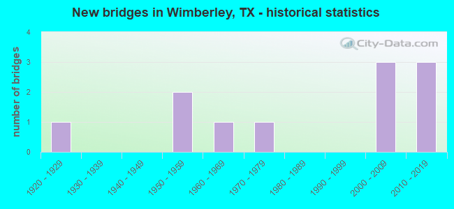
- New bridges - historical statistics
- 11920-1929
- 21950-1959
- 11960-1969
- 11970-1979
- 32000-2009
- 32010-2019

- Reconstructed bridges - Historical Statistics
- 11950-1959
- 01960-1969
- 01970-1979
- 01980-1989
- 01990-1999
- 12000-2009


- Bridge Condition - Deck
- 83.3%Good
- 16.7%Satisfactory

- Bridge Condition - Substructure
- 66.7%Good
- 33.3%Satisfactory

- Bridge Condition - Channel
- 9.1%Very good
- 63.6%Good
- 27.3%Satisfactory

- Bridge Condition - Culverts
- 60.0%Good
- 40.0%Satisfactory
Find on map >> Show street view
Structure Number: 141060028503002, Location: 16.5 MI S OF US 290 (Lat: 29.977694, Lng: -98.093397), Route carried "on" structure: State highway 12, Year Built: 1922, Year Reconstructed: 1964, Status: Open, Structure Length: 1.37m (4.49ft), Average Daily Traffic: 7,639 (year 2020), Truck Traffic: 5%, Average Future Daily Traffic: 13,830 (year 2033), Features Intersected: LEATH BRANCH
Minimum Vertical Clearance: 30+ m (98+ ft), Kilometerpoint: 26.372, Lanes on structure: 2, Owner: State Highway Agency, Approaching Roadway Width: 8.5m (27.9ft), Skew: 4 degrees, Material/Design: Concrete, Design/Construction: Culvert, Number Of Spans In Main Unit: 3, Length of Maximum Span: 2.7m (8.9ft), Curb-To-Curb Width: 9.5m (31.2ft), Out-to-Out Width: 15.5m (50.9ft)
Condition: Channel: Satisfactory, Culverts: Satisfactory, Operating Rating: 32.7 metric tons, Method Used To Determine Operating Rating: Field evaluation and documented engineering judgment, Inventory Rating: 24.5 metric tons, Method Used To Determine Inventory Rating: Field evaluation and documented engineering judgment, Structural Evaluation: Equal to present minimum criteria, Deck Geometry: High priority of corrective action, Waterway Adequacy: Equal to present minimum criteria, Approach Roadway Alignment: Equal to present desirable criteria, Length Of Structure Improvement: 1.37m (4.49ft), Designated Inspection Frequency: Every 24 months, Inspection Date: December 2020, Bridge Improvement Cost: $3,000, Roadway Improvement Cost: $1,000, Total Project Cost: $4,000, Deck Structure Type: Concrete Cast-file-Place, Wearing Surface/Protective System: Wearing Surface: Bituminous
Find on map >> Show street view
Structure Number: 141060028503003, Location: 0.2 MI S OF RM 3237 (Lat: 29.992972, Lng: -98.088117), Route carried "on" structure: State highway 12, Year Built: 1959, Status: Open, Structure Length: 13.41m (44.00ft), Average Daily Traffic: 7,639 (year 2020), Truck Traffic: 5%, Average Future Daily Traffic: 13,830 (year 2033), Design Load: H 20, Features Intersected: BLANCO RIVER
Minimum Vertical Clearance: 30+ m (98+ ft), Kilometerpoint: 24.420, Lanes on structure: 2, Owner: State Highway Agency, Approaching Roadway Width: 7.3m (24.0ft), Skew: 2 degrees, Material/Design: Prestressed concrete, Design/Construction: Stringer/Multi-beam, Number Of Spans In Main Unit: 4, Number Of Approach Spans: 5, Length of Maximum Span: 18.3m (60.0ft), Curb-To-Curb Width: 9.1m (29.9ft), Out-to-Out Width: 10.1m (33.1ft)
Condition: Deck: Satisfactory, Superstructure: Good, Substructure: Satisfactory, Channel: Satisfactory, Operating Rating: 68.0 metric tons, Method Used To Determine Operating Rating: Load Factor (LF), Inventory Rating: 40.8 metric tons, Method Used To Determine Inventory Rating: Load Factor (LF), Structural Evaluation: Equal to present minimum criteria, Deck Geometry: Meets minimum limits, Waterway Adequacy: Superior to present desirable criteria, Approach Roadway Alignment: Better than present minimum criteria, Designated Inspection Frequency: Every 24 months, Inspection Date: December 2020, Deck Structure Type: Concrete Cast-file-Place, Wearing Surface/Protective System: Wearing Surface: Bituminous
Find on map >> Show street view
Structure Number: 141060028503006, Location: 3.15 MI W OF SH 80 (Lat: 29.915317, Lng: -98.035122), Route carried "on" structure: State highway 12, Year Built: 2011, Status: Open, Structure Length: 6.86m (22.51ft), Average Daily Traffic: 11,656 (year 2020), Truck Traffic: 5%, Average Future Daily Traffic: 14,500 (year 2033), Design Load: HL 93, Features Intersected: SINK CREEK
Minimum Vertical Clearance: 30+ m (98+ ft), Kilometerpoint: 37.174, Lanes on structure: 2, Owner: State Highway Agency, Approaching Roadway Width: 13.4m (44.0ft), Material/Design: Prestressed concrete, Design/Construction: Stringer/Multi-beam, Number Of Spans In Main Unit: 3, Length of Maximum Span: 22.9m (75.1ft), Curb-To-Curb Width: 13.2m (43.3ft), Out-to-Out Width: 14.0m (45.9ft)
Condition: Deck: Good, Superstructure: Good, Substructure: Good, Channel: Satisfactory, Operating Rating: 54.4 metric tons, Method Used To Determine Operating Rating: Assigned ratings based on Load and Resistance Factor Design (LRFD) reported in metric tons, Inventory Rating: 32.7 metric tons, Method Used To Determine Inventory Rating: Assigned ratings based on Load and Resistance Factor Design (LRFD) reported in metric tons, Structural Evaluation: Better than present minimum criteria, Deck Geometry: Somewhat better than minimum adequacy, Waterway Adequacy: Equal to present minimum criteria, Approach Roadway Alignment: Equal to present desirable criteria, Designated Inspection Frequency: Every 24 months, Inspection Date: December 2020, Deck Structure Type: Concrete Precast Panels, Wearing Surface/Protective System: Wearing Surface: Monolithic Concrete
Find on map >> Show street view
Structure Number: 141060028503007, Location: 4.0 MI W OF SH 80 (Lat: 29.916397, Lng: -98.047919), Route carried "on" structure: State highway 12, Year Built: 2011, Status: Open, Structure Length: 0.70m (2.30ft), Average Daily Traffic: 11,656 (year 2020), Truck Traffic: 5%, Average Future Daily Traffic: 17,668 (year 2039), Design Load: HL 93, Features Intersected: BRANCH OF SINK CREEK
Minimum Vertical Clearance: 30+ m (98+ ft), Kilometerpoint: 35.806, Lanes on structure: 3, Owner: State Highway Agency, Approaching Roadway Width: 20.1m (65.9ft), Skew: 4 degrees, Material/Design: Concrete, Design/Construction: Culvert, Number Of Spans In Main Unit: 3, Length of Maximum Span: 1.2m (3.9ft)
Condition: Channel: Good, Culverts: Good, Operating Rating: 54.4 metric tons, Method Used To Determine Operating Rating: Assigned ratings based on Load and Resistance Factor Design (LRFD) reported in metric tons, Inventory Rating: 32.7 metric tons, Method Used To Determine Inventory Rating: Assigned ratings based on Load and Resistance Factor Design (LRFD) reported in metric tons, Structural Evaluation: Better than present minimum criteria, Waterway Adequacy: Equal to present minimum criteria, Approach Roadway Alignment: Equal to present desirable criteria, Designated Inspection Frequency: Every 48 months, Inspection Date: December 2020
Find on map >> Show street view
Structure Number: 141060028503008, Location: 3.75 MI W OF SH 80 (Lat: 29.917369, Lng: -98.043711), Route carried "on" structure: State highway 12, Year Built: 1950, Year Reconstructed: 2011, Status: Open, Structure Length: 0.70m (2.30ft), Average Daily Traffic: 11,656 (year 2020), Truck Traffic: 5%, Average Future Daily Traffic: 17,668 (year 2039), Features Intersected: DRAW
Minimum Vertical Clearance: 30+ m (98+ ft), Kilometerpoint: 36.238, Lanes on structure: 2, Owner: State Highway Agency, Approaching Roadway Width: 13.4m (44.0ft), Material/Design: Concrete, Design/Construction: Culvert, Number Of Spans In Main Unit: 3, Length of Maximum Span: 1.8m (5.9ft)
Condition: Channel: Good, Culverts: Good, Operating Rating: 32.7 metric tons, Method Used To Determine Operating Rating: Field evaluation and documented engineering judgment, Inventory Rating: 24.5 metric tons, Method Used To Determine Inventory Rating: Field evaluation and documented engineering judgment, Structural Evaluation: Equal to present minimum criteria, Waterway Adequacy: Meets minimum limits, Approach Roadway Alignment: Equal to present desirable criteria, Designated Inspection Frequency: Every 24 months, Inspection Date: December 2020
Find on map >> Show street view
Structure Number: 141060068303011, Location: 1.6 MI N OF RM 3237 (Lat: 30.012467, Lng: -98.103936), Route carried "on" structure: State highway 12, Year Built: 1961, Status: Open, Structure Length: 4.88m (16.01ft), Average Daily Traffic: 5,126 (year 2020), Truck Traffic: 5%, Average Future Daily Traffic: 10,480 (year 2033), Design Load: H 15, Features Intersected: CYPRESS CREEK
Minimum Vertical Clearance: 30+ m (98+ ft), Kilometerpoint: 21.512, Lanes on structure: 2, Owner: State Highway Agency, Approaching Roadway Width: 7.3m (24.0ft), Material/Design: Concrete continuous, Design/Construction: Slab, Number Of Spans In Main Unit: 4, Number Of Approach Spans: 2, Length of Maximum Span: 9.1m (29.9ft), Curb-To-Curb Width: 8.5m (27.9ft), Out-to-Out Width: 8.6m (28.2ft)
Condition: Deck: Good, Superstructure: Good, Substructure: Satisfactory, Channel: Good, Operating Rating: 48.1 metric tons, Method Used To Determine Operating Rating: Load and Resistance Factor (LRFR), Inventory Rating: 29.0 metric tons, Method Used To Determine Inventory Rating: Load and Resistance Factor (LRFR), Structural Evaluation: Equal to present minimum criteria, Deck Geometry: High priority of replacement, Waterway Adequacy: Equal to present desirable criteria, Approach Roadway Alignment: Equal to present desirable criteria, Length Of Structure Improvement: 4.88m (16.01ft), Designated Inspection Frequency: Every 24 months, Inspection Date: December 2020, Bridge Improvement Cost: $9,000, Roadway Improvement Cost: $2,000, Total Project Cost: $11,000, Deck Structure Type: Concrete Cast-file-Place, Wearing Surface/Protective System: Wearing Surface: Bituminous
Find on map >> Show street view
Structure Number: 141060068303075, Location: 0.45 MI NW OF RM 3237 (Lat: 29.996897, Lng: -98.097833), Route carried "on" structure: State highway 12, Year Built: 2005, Status: Open, Structure Length: 5.85m (19.19ft), Average Daily Traffic: 8,657 (year 2020), Truck Traffic: 5%, Average Future Daily Traffic: 12,180 (year 2033), Design Load: HS 20, Features Intersected: CYPRESS CREEK
Minimum Vertical Clearance: 30+ m (98+ ft), Kilometerpoint: 23.389, Lanes on structure: 3, Owner: State Highway Agency, Approaching Roadway Width: 12.8m (42.0ft), Skew: 1 degrees, Material/Design: Prestressed concrete, Design/Construction: Box Beam or Girders - Multiple, Number Of Spans In Main Unit: 4, Length of Maximum Span: 14.6m (47.9ft), Curb or Sidewalk Widths: Left: 1.8m (5.9ft), Right: 1.8m (5.9ft), Curb-To-Curb Width: 12.8m (42.0ft), Out-to-Out Width: 17.7m (58.1ft)
Condition: Deck: Good, Superstructure: Good, Substructure: Good, Channel: Good, Operating Rating: 54.4 metric tons, Method Used To Determine Operating Rating: Assigned rating based on Load Factor Design (LFD) reported in metric tons, Inventory Rating: 32.7 metric tons, Method Used To Determine Inventory Rating: Assigned rating based on Load Factor Design (LFD) reported in metric tons, Structural Evaluation: Better than present minimum criteria, Deck Geometry: Meets minimum limits, Waterway Adequacy: Equal to present minimum criteria, Approach Roadway Alignment: Meets minimum limits, Designated Inspection Frequency: Every 24 months, Inspection Date: December 2020, Deck Structure Type: Concrete Cast-file-Place, Wearing Surface/Protective System: Wearing Surface: Monolithic Concrete
Find on map >> Show street view
Structure Number: 14106008050401, Location: 4.1 MI E OF RM 12 (Lat: 30.014836, Lng: -98.044517), Route carried "on" structure: State highway 3237, Year Built: 1977, Status: Open, Structure Length: 2.93m (9.61ft), Average Daily Traffic: 2,880 (year 2020), Truck Traffic: 5%, Average Future Daily Traffic: 5,160 (year 2033), Design Load: H 15, Features Intersected: LONE MAN CREEK
Minimum Vertical Clearance: 30+ m (98+ ft), Kilometerpoint: 24.158, Lanes on structure: 2, Owner: State Highway Agency, Approaching Roadway Width: 7.3m (24.0ft), Skew: 2 degrees, Material/Design: Concrete, Design/Construction: Stringer/Multi-beam, Number Of Spans In Main Unit: 3, Length of Maximum Span: 9.8m (32.2ft), Curb-To-Curb Width: 6.7m (22.0ft), Out-to-Out Width: 7.9m (25.9ft)
Condition: Deck: Good, Superstructure: Good, Substructure: Good, Channel: Very good, Operating Rating: 65.3 metric tons, Method Used To Determine Operating Rating: Load Factor (LF), Inventory Rating: 39.0 metric tons, Method Used To Determine Inventory Rating: Load Factor (LF), Structural Evaluation: Better than present minimum criteria, Deck Geometry: High priority of replacement, Waterway Adequacy: Equal to present minimum criteria, Approach Roadway Alignment: Equal to present desirable criteria, Length Of Structure Improvement: 2.93m (9.61ft), Designated Inspection Frequency: Every 24 months, Inspection Date: November 2020, Bridge Improvement Cost: $5,000, Roadway Improvement Cost: $1,000, Total Project Cost: $6,000, Deck Structure Type: Concrete Cast-file-Place, Wearing Surface/Protective System: Wearing Surface: Bituminous
Find on map >> Show street view
Structure Number: 141060AA0279001, Location: 1.10 MI SW OF RM 2325 (Lat: 29.990975, Lng: -98.111286), Route carried "on" structure: County highway , Year Built: 2010, Status: Open, Structure Length: 1.04m (3.41ft), Average Daily Traffic: 1,354 (year 2020), Average Future Daily Traffic: 500 (year 2030), Features Intersected: WILSON CREEK, Facility Carried by Structure: GREEN ACRES DR
Minimum Vertical Clearance: 30+ m (98+ ft), Kilometerpoint: 1.690, Lanes on structure: 2, Owner: County Highway Agency, Approaching Roadway Width: 6.7m (22.0ft), Material/Design: Concrete, Design/Construction: Arch - Deck, Number Of Spans In Main Unit: 1, Length of Maximum Span: 10.1m (33.1ft), Curb-To-Curb Width: 9.6m (31.5ft), Out-to-Out Width: 11.3m (37.1ft)
Condition: Deck: Good, Superstructure: Good, Substructure: Good, Channel: Good, Operating Rating: 32.7 metric tons, Method Used To Determine Operating Rating: Field evaluation and documented engineering judgment, Inventory Rating: 24.5 metric tons, Method Used To Determine Inventory Rating: Field evaluation and documented engineering judgment, Structural Evaluation: Equal to present minimum criteria, Deck Geometry: Somewhat better than minimum adequacy, Waterway Adequacy: Better than present minimum criteria, Approach Roadway Alignment: Equal to present minimum criteria, Designated Inspection Frequency: Every 24 months, Inspection Date: April 2020, Deck Structure Type: Concrete Precast Panels
Find on map >> Show street view
Structure Number: 141060AA3000001, Location: 0.40 MI E OF RM 12 (Lat: 30.027050, Lng: -98.094953), Route carried "on" structure: County highway , Year Built: 2006, Status: Open, Structure Length: 2.77m (9.09ft), Average Daily Traffic: 1,000 (year 2014), Truck Traffic: 6%, Average Future Daily Traffic: 2,000 (year 2034), Features Intersected: TRIB OF CYPRESS CREEK, Facility Carried by Structure: WINTERS MILL PKWY
Minimum Vertical Clearance: 30+ m (98+ ft), Kilometerpoint: 0.819, Lanes on structure: 2, Owner: County Highway Agency, Approaching Roadway Width: 9.8m (32.2ft), Skew: 4 degrees, Material/Design: Concrete, Design/Construction: Culvert, Number Of Spans In Main Unit: 6, Length of Maximum Span: 3.0m (9.8ft), Curb-To-Curb Width: 9.7m (31.8ft), Out-to-Out Width: 22.0m (72.2ft)
Condition: Channel: Good, Culverts: Satisfactory, Operating Rating: 32.7 metric tons, Method Used To Determine Operating Rating: Field evaluation and documented engineering judgment, Inventory Rating: 24.5 metric tons, Method Used To Determine Inventory Rating: Field evaluation and documented engineering judgment, Structural Evaluation: Equal to present minimum criteria, Deck Geometry: Equal to present minimum criteria, Waterway Adequacy: Better than present minimum criteria, Approach Roadway Alignment: Equal to present desirable criteria, Designated Inspection Frequency: Every 24 months, Inspection Date: April 2020, Deck Structure Type: Concrete Cast-file-Place, Wearing Surface/Protective System: Wearing Surface: Bituminous
Find on map >> Show street view
Structure Number: 141060AA3000002, Location: 1.50 MI SE OF RM 12 (Lat: 30.013692, Lng: -98.085064), Route carried "on" structure: County highway , Year Built: 2006, Status: Open, Structure Length: 1.62m (5.31ft), Average Daily Traffic: 1,000 (year 2014), Truck Traffic: 6%, Average Future Daily Traffic: 2,000 (year 2034), Features Intersected: TRIB OF CYPRESS CREEK, Facility Carried by Structure: WINTERS MILL PKWY
Minimum Vertical Clearance: 30+ m (98+ ft), Kilometerpoint: 2.540, Lanes on structure: 2, Owner: County Highway Agency, Approaching Roadway Width: 9.8m (32.2ft), Skew: 4 degrees, Material/Design: Concrete, Design/Construction: Culvert, Number Of Spans In Main Unit: 5, Length of Maximum Span: 2.4m (7.9ft), Curb-To-Curb Width: 9.9m (32.5ft), Out-to-Out Width: 15.6m (51.2ft)
Condition: Channel: Good, Culverts: Good, Operating Rating: 44.4 metric tons, Method Used To Determine Operating Rating: Field evaluation and documented engineering judgment, Inventory Rating: 32.7 metric tons, Method Used To Determine Inventory Rating: Field evaluation and documented engineering judgment, Structural Evaluation: Better than present minimum criteria, Deck Geometry: Equal to present minimum criteria, Waterway Adequacy: Better than present minimum criteria, Approach Roadway Alignment: Equal to present desirable criteria, Designated Inspection Frequency: Every 24 months, Inspection Date: April 2020, Deck Structure Type: Concrete Cast-file-Place, Wearing Surface/Protective System: Wearing Surface: Bituminous