Bridge Statistics for Wikieup, Arizona (AZ)
Condition, Traffic, Stress, Structural Evaluation, Project Costs
- National Bridge Inventory (NBI) Statistics
- 22Number of bridges
- 377ft / 115mTotal length
- $8,000Total costs
- 133,306Total average daily traffic
- 24,436Total average daily truck traffic
- 133,526Total future (year 2038) average daily traffic
- National Bridge Inventory (NBI) Registered Bridges for Wikieup
- No street view available for this location
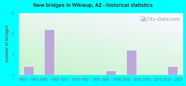
- New bridges - historical statistics
- 21950-1959
- 111960-1969
- 11990-1999
- 62000-2009
- 22020-2022

- Reconstructed bridges - Historical Statistics
- 31980-1989
- 51990-1999


- Bridge Condition - Deck
- 7.7%Very good
- 61.5%Good
- 30.8%Satisfactory

- Bridge Condition - Superstructure
- 53.8%Very good
- 23.1%Good
- 23.1%Satisfactory

- Bridge Condition - Substructure
- 30.8%Very good
- 61.5%Good
- 7.7%Satisfactory

- Bridge Condition - Channel
- 9.1%Excellent
- 63.6%Good
- 27.3%Satisfactory

- Bridge Condition - Culverts
- 88.9%Good
- 11.1%Satisfactory
Find on map >> Show street view
Structure Number: 639, Location: 30.3 mi S Jct I-40 (Lat: 34.736200, Lng: -113.615300), Route carried "on" structure: US 93, Year Built: 1961, Status: Open, Structure Length: 5.24m (17.19ft), Average Daily Traffic: 8,668 (year 2017), Truck Traffic: 21%, Average Future Daily Traffic: 8,678 (year 2038), Design Load: HS 20, Features Intersected: Natural Corral Wash
Minimum Vertical Clearance: 30+ m (98+ ft), Kilometerpoint: 195.503, Lanes on structure: 2, Owner: State Highway Agency, Approaching Roadway Width: 10.4m (34.1ft), Material/Design: Concrete continuous, Design/Construction: Slab, Number Of Spans In Main Unit: 6, Length of Maximum Span: 9.1m (29.9ft), Curb-To-Curb Width: 9.7m (31.8ft), Out-to-Out Width: 10.7m (35.1ft)
Condition: Deck: Satisfactory, Superstructure: Satisfactory, Substructure: Good, Channel: Satisfactory, Operating Rating: 37.2 metric tons, Method Used To Determine Operating Rating: Load Factor (LF), Inventory Rating: 21.8 metric tons, Method Used To Determine Inventory Rating: Load Factor (LF), Structural Evaluation: Somewhat better than minimum adequacy, Deck Geometry: High priority of corrective action, Waterway Adequacy: Equal to present desirable criteria, Approach Roadway Alignment: Equal to present desirable criteria, Length Of Structure Improvement: 6.13m (20.11ft), Designated Inspection Frequency: Every 24 months, Inspection Date: December 2020, Total Project Cost: $1,000 ( Estimate for 2016), Deck Structure Type: Concrete Cast-file-Place, Wearing Surface/Protective System: Wearing Surface: Bituminous
Find on map >> Show street view
Structure Number: 64, Location: 36.4 mi S Jct I-40 (Lat: 34.655600, Lng: -113.575000), Route carried "on" structure: US 93, Year Built: 1961, Status: Open, Structure Length: 5.24m (17.19ft), Average Daily Traffic: 3,346 (year 2017), Truck Traffic: 15%, Average Future Daily Traffic: 3,356 (year 2038), Design Load: HS 20, Features Intersected: Sycamore Creek
Minimum Vertical Clearance: 30+ m (98+ ft), Kilometerpoint: 205.401, Lanes on structure: 2, Owner: State Highway Agency, Approaching Roadway Width: 10.4m (34.1ft), Skew: 1 degrees, Material/Design: Concrete continuous, Design/Construction: Slab, Number Of Spans In Main Unit: 6, Length of Maximum Span: 9.1m (29.9ft), Curb-To-Curb Width: 9.7m (31.8ft), Out-to-Out Width: 10.7m (35.1ft)
Condition: Deck: Satisfactory, Superstructure: Satisfactory, Substructure: Good, Channel: Good, Operating Rating: 39.9 metric tons, Method Used To Determine Operating Rating: Load Factor (LF), Inventory Rating: 24.5 metric tons, Method Used To Determine Inventory Rating: Load Factor (LF), Structural Evaluation: Equal to present minimum criteria, Deck Geometry: Meets minimum limits, Waterway Adequacy: Equal to present desirable criteria, Approach Roadway Alignment: Equal to present desirable criteria, Length Of Structure Improvement: 5.24m (17.19ft), Designated Inspection Frequency: Every 24 months, Inspection Date: December 2020, Bridge Improvement Cost: $1,000, Roadway Improvement Cost: $1,000, Total Project Cost: $2,000 ( Estimate for 2020), Deck Structure Type: Concrete Cast-file-Place, Wearing Surface/Protective System: Wearing Surface: Monolithic Concrete
Find on map >> Show street view
Structure Number: 641, Location: 37.4 mi S Jct I-40 (Lat: 34.643900, Lng: -113.566300), Route carried "on" structure: US 93, Year Built: 1961, Status: Open, Structure Length: 3.41m (11.19ft), Average Daily Traffic: 3,748 (year 2017), Truck Traffic: 15%, Average Future Daily Traffic: 3,758 (year 2038), Design Load: HS 20, Features Intersected: Gray Wash
Minimum Vertical Clearance: 30+ m (98+ ft), Kilometerpoint: 207.010, Lanes on structure: 2, Owner: State Highway Agency, Approaching Roadway Width: 10.4m (34.1ft), Skew: 2 degrees, Material/Design: Concrete continuous, Design/Construction: Slab, Number Of Spans In Main Unit: 4, Length of Maximum Span: 9.1m (29.9ft), Curb-To-Curb Width: 10.9m (35.8ft), Out-to-Out Width: 11.9m (39.0ft)
Condition: Deck: Satisfactory, Superstructure: Satisfactory, Substructure: Satisfactory, Channel: Good, Operating Rating: 40.8 metric tons, Method Used To Determine Operating Rating: Load Factor (LF), Inventory Rating: 24.5 metric tons, Method Used To Determine Inventory Rating: Load Factor (LF), Structural Evaluation: Equal to present minimum criteria, Deck Geometry: Somewhat better than minimum adequacy, Waterway Adequacy: Equal to present desirable criteria, Approach Roadway Alignment: Equal to present minimum criteria, Designated Inspection Frequency: Every 24 months, Inspection Date: December 2020, Deck Structure Type: Concrete Cast-file-Place, Wearing Surface/Protective System: Wearing Surface: Monolithic Concrete
Find on map >> Show street view
Structure Number: 666, Location: 34.8 mi S Jct I-40 (Lat: 34.676300, Lng: -113.591500), Route carried "on" structure: US 93, Year Built: 1961, Status: Open, Structure Length: 5.67m (18.60ft), Average Daily Traffic: 3,748 (year 2017), Truck Traffic: 15%, Average Future Daily Traffic: 3,758 (year 2038), Design Load: HS 20, Features Intersected: Bronco Wash
Minimum Vertical Clearance: 30+ m (98+ ft), Kilometerpoint: 202.697, Lanes on structure: 2, Owner: State Highway Agency, Approaching Roadway Width: 9.8m (32.2ft), Skew: 3 degrees, Material/Design: Prestressed concrete, Design/Construction: Stringer/Multi-beam, Number Of Spans In Main Unit: 3, Length of Maximum Span: 18.6m (61.0ft), Curb-To-Curb Width: 9.7m (31.8ft), Out-to-Out Width: 10.7m (35.1ft)
Condition: Deck: Good, Superstructure: Very good, Substructure: Good, Channel: Satisfactory, Operating Rating: 89.8 metric tons, Method Used To Determine Operating Rating: Load Factor (LF), Inventory Rating: 39.9 metric tons, Method Used To Determine Inventory Rating: Load Factor (LF), Structural Evaluation: Better than present minimum criteria, Deck Geometry: Meets minimum limits, Waterway Adequacy: Equal to present desirable criteria, Approach Roadway Alignment: Equal to present desirable criteria, Designated Inspection Frequency: Every 24 months, Inspection Date: December 2020, Deck Structure Type: Concrete Cast-file-Place, Wearing Surface/Protective System: Wearing Surface: Monolithic Concrete
Find on map >> Show street view
Structure Number: 2355, Location: 35.7 mi S Jct I-40 (Lat: 34.662800, Lng: -113.580700), Route carried "on" structure: US 93, Year Built: 1993, Status: Open, Structure Length: 26.85m (88.09ft), Average Daily Traffic: 3,346 (year 2017), Truck Traffic: 15%, Average Future Daily Traffic: 3,356 (year 2038), Design Load: HS 20, Features Intersected: Big Sandy River
Minimum Vertical Clearance: 30+ m (98+ ft), Kilometerpoint: 204.387, Lanes on structure: 2, Owner: State Highway Agency, Approaching Roadway Width: 12.2m (40.0ft), Material/Design: Prestressed concrete continuous, Design/Construction: Stringer/Multi-beam, Number Of Spans In Main Unit: 7, Length of Maximum Span: 38.1m (125.0ft), Curb-To-Curb Width: 13.4m (44.0ft), Out-to-Out Width: 14.4m (47.2ft)
Condition: Deck: Satisfactory, Superstructure: Very good, Substructure: Good, Channel: Satisfactory, Operating Rating: 89.8 metric tons, Method Used To Determine Operating Rating: Load Factor (LF), Inventory Rating: 40.8 metric tons, Method Used To Determine Inventory Rating: Load Factor (LF), Structural Evaluation: Better than present minimum criteria, Deck Geometry: Superior to present desirable criteria, Waterway Adequacy: Equal to present desirable criteria, Approach Roadway Alignment: Equal to present desirable criteria, Designated Inspection Frequency: Every 24 months, Inspection Date: December 2020, Deck Structure Type: Concrete Cast-file-Place, Wearing Surface/Protective System: Wearing Surface: Monolithic Concrete
Find on map >> Show street view
Structure Number: 2621, Location: 35.7 mi S Jct I-40 (Lat: 34.662700, Lng: -113.580900), Route carried "on" structure: US 93, Year Built: 2004, Status: Open, Structure Length: 26.76m (87.80ft), Average Daily Traffic: 3,748 (year 2017), Truck Traffic: 17%, Average Future Daily Traffic: 3,758 (year 2038), Design Load: HS 20, Features Intersected: Big Sandy River
Minimum Vertical Clearance: 30+ m (98+ ft), Kilometerpoint: 204.065, Lanes on structure: 2, Owner: State Highway Agency, Approaching Roadway Width: 11.6m (38.1ft), Material/Design: Prestressed concrete continuous, Design/Construction: Stringer/Multi-beam, Number Of Spans In Main Unit: 7, Length of Maximum Span: 38.1m (125.0ft), Curb-To-Curb Width: 12.8m (42.0ft), Out-to-Out Width: 13.7m (44.9ft)
Condition: Deck: Good, Superstructure: Very good, Substructure: Good, Channel: Satisfactory, Operating Rating: 89.8 metric tons, Method Used To Determine Operating Rating: Load Factor (LF), Inventory Rating: 34.5 metric tons, Method Used To Determine Inventory Rating: Load Factor (LF), Structural Evaluation: Better than present minimum criteria, Deck Geometry: Equal to present desirable criteria, Waterway Adequacy: Equal to present desirable criteria, Approach Roadway Alignment: Equal to present desirable criteria, Designated Inspection Frequency: Every 24 months, Inspection Date: December 2020, Deck Structure Type: Concrete Cast-file-Place, Wearing Surface/Protective System: Wearing Surface: Monolithic Concrete
Find on map >> Show street view
Structure Number: 2623, Location: 37.4 mi S Jct I-40 (Lat: 34.643600, Lng: -113.566300), Route carried "on" structure: US 93, Year Built: 2003, Status: Open, Structure Length: 7.44m (24.41ft), Average Daily Traffic: 3,748 (year 2017), Truck Traffic: 15%, Average Future Daily Traffic: 3,758 (year 2038), Design Load: HS 20, Features Intersected: Gray Wash
Minimum Vertical Clearance: 30+ m (98+ ft), Kilometerpoint: 207.010, Lanes on structure: 2, Owner: State Highway Agency, Approaching Roadway Width: 11.6m (38.1ft), Material/Design: Prestressed concrete continuous, Design/Construction: Stringer/Multi-beam, Number Of Spans In Main Unit: 3, Length of Maximum Span: 24.4m (80.1ft), Curb-To-Curb Width: 12.8m (42.0ft), Out-to-Out Width: 13.7m (44.9ft)
Condition: Deck: Good, Superstructure: Good, Substructure: Good, Channel: Good, Operating Rating: 81.6 metric tons, Method Used To Determine Operating Rating: Load Factor (LF), Inventory Rating: 38.1 metric tons, Method Used To Determine Inventory Rating: Load Factor (LF), Structural Evaluation: Better than present minimum criteria, Deck Geometry: Equal to present desirable criteria, Waterway Adequacy: Equal to present desirable criteria, Approach Roadway Alignment: Equal to present desirable criteria, Designated Inspection Frequency: Every 24 months, Inspection Date: January 2022, Deck Structure Type: Concrete Cast-file-Place, Wearing Surface/Protective System: Wearing Surface: Monolithic Concrete
Find on map >> Show street view
Structure Number: 2624, Location: 34.8 mi S Jct I-40 (Lat: 34.676100, Lng: -113.590900), Route carried "on" structure: US 93, Year Built: 2004, Status: Open, Structure Length: 9.27m (30.41ft), Average Daily Traffic: 3,346 (year 2017), Truck Traffic: 15%, Average Future Daily Traffic: 3,356 (year 2038), Design Load: HS 20, Features Intersected: Bronco Wash
Minimum Vertical Clearance: 30+ m (98+ ft), Kilometerpoint: 202.697, Lanes on structure: 2, Owner: State Highway Agency, Approaching Roadway Width: 11.6m (38.1ft), Material/Design: Prestressed concrete continuous, Design/Construction: Stringer/Multi-beam, Number Of Spans In Main Unit: 3, Length of Maximum Span: 30.5m (100.1ft), Curb-To-Curb Width: 12.8m (42.0ft), Out-to-Out Width: 13.7m (44.9ft)
Condition: Deck: Good, Superstructure: Very good, Substructure: Good, Channel: Good, Operating Rating: 89.8 metric tons, Method Used To Determine Operating Rating: Load Factor (LF), Inventory Rating: 35.4 metric tons, Method Used To Determine Inventory Rating: Load Factor (LF), Structural Evaluation: Better than present minimum criteria, Deck Geometry: Equal to present desirable criteria, Waterway Adequacy: Equal to present desirable criteria, Approach Roadway Alignment: Equal to present desirable criteria, Designated Inspection Frequency: Every 24 months, Inspection Date: December 2020, Deck Structure Type: Concrete Cast-file-Place, Wearing Surface/Protective System: Wearing Surface: Monolithic Concrete
Find on map >> Show street view
Structure Number: 2633, Location: 29.1 mi S Jct I-40 (Lat: 34.753700, Lng: -113.615700), Route carried "on" structure: US 93, Year Built: 2008, Status: Open, Structure Length: 2.26m (7.41ft), Average Daily Traffic: 4,254 (year 2017), Truck Traffic: 21%, Average Future Daily Traffic: 4,264 (year 2038), Design Load: HS 20, Features Intersected: Tompkins Canyon
Minimum Vertical Clearance: 30+ m (98+ ft), Kilometerpoint: 193.604, Lanes on structure: 2, Owner: State Highway Agency, Approaching Roadway Width: 11.6m (38.1ft), Material/Design: Concrete continuous, Design/Construction: Slab, Number Of Spans In Main Unit: 2, Length of Maximum Span: 11.0m (36.1ft), Curb-To-Curb Width: 12.8m (42.0ft), Out-to-Out Width: 13.7m (44.9ft)
Condition: Deck: Good, Superstructure: Good, Substructure: Very good, Channel: Good, Operating Rating: 89.8 metric tons, Method Used To Determine Operating Rating: Load Factor (LF), Inventory Rating: 65.3 metric tons, Method Used To Determine Inventory Rating: Load Factor (LF), Structural Evaluation: Better than present minimum criteria, Deck Geometry: Equal to present desirable criteria, Waterway Adequacy: Equal to present desirable criteria, Approach Roadway Alignment: Equal to present desirable criteria, Designated Inspection Frequency: Every 24 months, Inspection Date: December 2020, Deck Structure Type: Concrete Cast-file-Place, Wearing Surface/Protective System: Wearing Surface: Monolithic Concrete
Find on map >> Show street view
Structure Number: 2649, Location: 41.0 mi SE Jct I-40 (Lat: 34.631300, Lng: -113.546100), Route carried "on" structure: US 93, Year Built: 2001, Status: Open, Structure Length: 1.98m (6.50ft), Average Daily Traffic: 3,748 (year 2017), Truck Traffic: 15%, Average Future Daily Traffic: 3,758 (year 2038), Design Load: HS 20, Features Intersected: Wash
Minimum Vertical Clearance: 30+ m (98+ ft), Kilometerpoint: 209.408, Lanes on structure: 2, Owner: State Highway Agency, Approaching Roadway Width: 11.6m (38.1ft), Skew: 1 degrees, Material/Design: Prestressed concrete, Design/Construction: Stringer/Multi-beam, Number Of Spans In Main Unit: 1, Length of Maximum Span: 18.6m (61.0ft), Curb-To-Curb Width: 12.8m (42.0ft), Out-to-Out Width: 13.7m (44.9ft)
Condition: Deck: Good, Superstructure: Very good, Substructure: Very good, Channel: Satisfactory, Operating Rating: 83.5 metric tons, Method Used To Determine Operating Rating: Load Factor (LF), Inventory Rating: 39.9 metric tons, Method Used To Determine Inventory Rating: Load Factor (LF), Structural Evaluation: Equal to present desirable criteria, Deck Geometry: Equal to present desirable criteria, Waterway Adequacy: Equal to present desirable criteria, Approach Roadway Alignment: Equal to present desirable criteria, Designated Inspection Frequency: Every 24 months, Inspection Date: December 2020, Deck Structure Type: Concrete Cast-file-Place, Wearing Surface/Protective System: Wearing Surface: Monolithic Concrete
Find on map >> Show street view
Structure Number: 2861, Location: 29.1 mi S Jct I-40 (Lat: 34.753700, Lng: -113.616300), Route carried "on" structure: US 93, Year Built: 2008, Status: Open, Structure Length: 2.26m (7.41ft), Average Daily Traffic: 4,226 (year 2017), Truck Traffic: 21%, Average Future Daily Traffic: 4,236 (year 2038), Design Load: HS 20, Features Intersected: Tompkins Canyon
Minimum Vertical Clearance: 30+ m (98+ ft), Kilometerpoint: 193.604, Lanes on structure: 2, Owner: State Highway Agency, Approaching Roadway Width: 11.6m (38.1ft), Material/Design: Concrete continuous, Design/Construction: Slab, Number Of Spans In Main Unit: 2, Length of Maximum Span: 11.0m (36.1ft), Curb-To-Curb Width: 12.8m (42.0ft), Out-to-Out Width: 13.7m (44.9ft)
Condition: Deck: Good, Superstructure: Good, Substructure: Good, Channel: Good, Operating Rating: 89.8 metric tons, Method Used To Determine Operating Rating: Load Factor (LF), Inventory Rating: 65.3 metric tons, Method Used To Determine Inventory Rating: Load Factor (LF), Structural Evaluation: Better than present minimum criteria, Deck Geometry: Equal to present desirable criteria, Waterway Adequacy: Equal to present desirable criteria, Approach Roadway Alignment: Equal to present desirable criteria, Designated Inspection Frequency: Every 24 months, Inspection Date: December 2020, Deck Structure Type: Concrete Cast-file-Place, Wearing Surface/Protective System: Wearing Surface: Monolithic Concrete
Find on map >> Show street view
Structure Number: 4965, Location: 31.4 mi to 91 MP (Lat: 34.729000, Lng: -113.615100), Route carried "on" structure: US 93, Year Built: 1953, Year Reconstructed: 1994, Status: Open, Structure Length: 1.31m (4.30ft), Average Daily Traffic: 8,527 (year 2021), Truck Traffic: 19%, Average Future Daily Traffic: 8,537 (year 2041), Design Load: HS 20, Features Intersected: Wash
Minimum Vertical Clearance: 30+ m (98+ ft), Kilometerpoint: 197.145, Lanes on structure: 2, Owner: State Highway Agency, Approaching Roadway Width: 15.5m (50.9ft), Material/Design: Concrete continuous, Design/Construction: Culvert, Number Of Spans In Main Unit: 4, Length of Maximum Span: 3.0m (9.8ft), Curb or Sidewalk Widths: Left: 0.3m (1.0ft), Right: 0.3m (1.0ft), Curb-To-Curb Width: 15.5m (50.9ft), Out-to-Out Width: 27.1m (88.9ft)
Condition: Channel: Good, Culverts: Good, Operating Rating: 53.5 metric tons, Method Used To Determine Operating Rating: Load Factor (LF), Inventory Rating: 32.7 metric tons, Method Used To Determine Inventory Rating: Load Factor (LF), Structural Evaluation: Better than present minimum criteria, Deck Geometry: Superior to present desirable criteria, Waterway Adequacy: Equal to present desirable criteria, Approach Roadway Alignment: Equal to present desirable criteria, Designated Inspection Frequency: Every 48 months, Inspection Date: April 2021, Deck Structure Type: Concrete Cast-file-Place, Wearing Surface/Protective System: Wearing Surface: Bituminous
Find on map >> Show street view
Structure Number: 4966, Location: 31.5 mi S Jct W/ I 40 (Lat: 34.725100, Lng: -113.615000), Route carried "on" structure: US 93, Year Built: 1953, Year Reconstructed: 1994, Status: Open, Structure Length: 1.31m (4.30ft), Average Daily Traffic: 9,582 (year 2019), Truck Traffic: 19%, Average Future Daily Traffic: 9,592 (year 2039), Design Load: HS 20, Features Intersected: Wash
Minimum Vertical Clearance: 30+ m (98+ ft), Kilometerpoint: 197.610, Lanes on structure: 2, Owner: State Highway Agency, Approaching Roadway Width: 7.9m (25.9ft), Material/Design: Concrete continuous, Design/Construction: Culvert, Number Of Spans In Main Unit: 4, Length of Maximum Span: 3.0m (9.8ft), Curb or Sidewalk Widths: Left: 0.3m (1.0ft), Right: 0.3m (1.0ft), Curb-To-Curb Width: 25.9m (85.0ft), Out-to-Out Width: 26.5m (86.9ft)
Condition: Channel: Good, Culverts: Good, Operating Rating: 49.9 metric tons, Method Used To Determine Operating Rating: Load Factor (LF), Inventory Rating: 29.9 metric tons, Method Used To Determine Inventory Rating: Load Factor (LF), Structural Evaluation: Better than present minimum criteria, Deck Geometry: Superior to present desirable criteria, Waterway Adequacy: Equal to present desirable criteria, Approach Roadway Alignment: Equal to present desirable criteria, Length Of Structure Improvement: 2.07m (6.79ft), Designated Inspection Frequency: Every 48 months, Inspection Date: April 2021, Total Project Cost: $1,000 ( Estimate for 2021), Deck Structure Type: Concrete Cast-file-Place, Wearing Surface/Protective System: Wearing Surface: Bituminous
Find on map >> Show street view
Structure Number: 4967, Location: 32.9 mi S Jct W/ I 40 (Lat: 34.699300, Lng: -113.609400), Route carried "on" structure: US 93, Year Built: 1962, Year Reconstructed: 1994, Status: Open, Structure Length: 0.64m (2.10ft), Average Daily Traffic: 8,527 (year 2021), Truck Traffic: 19%, Average Future Daily Traffic: 8,537 (year 2041), Design Load: HS 20, Features Intersected: Wash
Minimum Vertical Clearance: 30+ m (98+ ft), Kilometerpoint: 199.800, Lanes on structure: 3, Owner: State Highway Agency, Approaching Roadway Width: 12.2m (40.0ft), Material/Design: Concrete continuous, Design/Construction: Culvert, Number Of Spans In Main Unit: 2, Length of Maximum Span: 3.0m (9.8ft), Curb or Sidewalk Widths: Left: 1.5m (4.9ft), Right: 1.5m (4.9ft)
Condition: Channel: Good, Culverts: Good, Operating Rating: 64.4 metric tons, Method Used To Determine Operating Rating: Load Factor (LF), Inventory Rating: 38.1 metric tons, Method Used To Determine Inventory Rating: Load Factor (LF), Structural Evaluation: Better than present minimum criteria, Waterway Adequacy: Equal to present desirable criteria, Approach Roadway Alignment: Equal to present desirable criteria, Length Of Structure Improvement: 1.22m (4.00ft), Designated Inspection Frequency: Every 48 months, Inspection Date: April 2021
Find on map >> Show street view
Structure Number: 4968, Location: 33.0 mi S Jct W/ I 40 (Lat: 34.697700, Lng: -113.608600), Route carried "on" structure: US 93, Year Built: 1962, Year Reconstructed: 2004, Status: Open, Structure Length: 0.64m (2.10ft), Average Daily Traffic: 8,527 (year 2021), Truck Traffic: 19%, Average Future Daily Traffic: 8,537 (year 2041), Design Load: HS 20, Features Intersected: Wash
Minimum Vertical Clearance: 30+ m (98+ ft), Kilometerpoint: 199.960, Lanes on structure: 2, Owner: State Highway Agency, Approaching Roadway Width: 12.2m (40.0ft), Material/Design: Concrete continuous, Design/Construction: Culvert, Number Of Spans In Main Unit: 2, Length of Maximum Span: 3.0m (9.8ft)
Condition: Channel: Good, Culverts: Good, Operating Rating: 60.8 metric tons, Method Used To Determine Operating Rating: Load Factor (LF), Inventory Rating: 36.3 metric tons, Method Used To Determine Inventory Rating: Load Factor (LF), Structural Evaluation: Better than present minimum criteria, Waterway Adequacy: Equal to present desirable criteria, Approach Roadway Alignment: Equal to present desirable criteria, Designated Inspection Frequency: Every 48 months, Inspection Date: April 2021
Find on map >> Show street view
Structure Number: 4969, Location: 33.1 mi S Jct W/ I 40 (Lat: 34.696400, Lng: -113.607900), Route carried "on" structure: US 93, Year Built: 1962, Year Reconstructed: 2004, Status: Open, Structure Length: 0.98m (3.22ft), Average Daily Traffic: 8,527 (year 2021), Truck Traffic: 19%, Average Future Daily Traffic: 8,537 (year 2041), Design Load: HS 20, Features Intersected: Wash
Minimum Vertical Clearance: 30+ m (98+ ft), Kilometerpoint: 200.120, Lanes on structure: 2, Owner: State Highway Agency, Approaching Roadway Width: 12.2m (40.0ft), Material/Design: Concrete continuous, Design/Construction: Culvert, Number Of Spans In Main Unit: 3, Length of Maximum Span: 3.0m (9.8ft)
Condition: Channel: Good, Culverts: Good, Operating Rating: 63.5 metric tons, Method Used To Determine Operating Rating: Load Factor (LF), Inventory Rating: 38.1 metric tons, Method Used To Determine Inventory Rating: Load Factor (LF), Structural Evaluation: Better than present minimum criteria, Waterway Adequacy: Better than present minimum criteria, Approach Roadway Alignment: Equal to present desirable criteria, Designated Inspection Frequency: Every 48 months, Inspection Date: April 2021
Find on map >> Show street view
Structure Number: 497, Location: 33.6 mi S Jct W/ I 40 (Lat: 34.690500, Lng: -113.604000), Route carried "on" structure: US 93, Year Built: 1968, Year Reconstructed: 2003, Status: Open, Structure Length: 1.65m (5.41ft), Average Daily Traffic: 8,527 (year 2021), Truck Traffic: 18%, Average Future Daily Traffic: 8,537 (year 2041), Design Load: HS 20, Features Intersected: Wash
Minimum Vertical Clearance: 30+ m (98+ ft), Kilometerpoint: 200.900, Lanes on structure: 2, Owner: State Highway Agency, Approaching Roadway Width: 12.2m (40.0ft), Material/Design: Concrete continuous, Design/Construction: Culvert, Number Of Spans In Main Unit: 5, Length of Maximum Span: 3.0m (9.8ft)
Condition: Channel: Good, Culverts: Good, Operating Rating: 89.8 metric tons, Method Used To Determine Operating Rating: Load Factor (LF), Inventory Rating: 89.8 metric tons, Method Used To Determine Inventory Rating: Load Factor (LF), Structural Evaluation: Better than present minimum criteria, Waterway Adequacy: Better than present minimum criteria, Approach Roadway Alignment: Equal to present desirable criteria, Length Of Structure Improvement: 2.41m (7.91ft), Designated Inspection Frequency: Every 48 months, Inspection Date: April 2021, Total Project Cost: $1,000 ( Estimate for 2021)
Find on map >> Show street view
Structure Number: 4971, Location: 37.9 mi SE Jct I 40 (Lat: 34.644444, Lng: -113.569444), Route carried "on" structure: US 93, Year Built: 1962, Year Reconstructed: 2003, Status: Open, Structure Length: 0.64m (2.10ft), Average Daily Traffic: 8,527 (year 2021), Truck Traffic: 18%, Average Future Daily Traffic: 8,537 (year 2041), Design Load: HS 20, Features Intersected: Wash
Minimum Vertical Clearance: 30+ m (98+ ft), Kilometerpoint: 207.830, Lanes on structure: 4, Owner: State Highway Agency, Approaching Roadway Width: 12.2m (40.0ft), Material/Design: Concrete continuous, Design/Construction: Culvert, Number Of Spans In Main Unit: 2, Length of Maximum Span: 3.0m (9.8ft)
Condition: Channel: Good, Culverts: Good, Operating Rating: 89.8 metric tons, Method Used To Determine Operating Rating: Load Factor (LF), Inventory Rating: 89.8 metric tons, Method Used To Determine Inventory Rating: Load Factor (LF), Structural Evaluation: Better than present minimum criteria, Waterway Adequacy: Equal to present desirable criteria, Approach Roadway Alignment: Equal to present desirable criteria, Length Of Structure Improvement: 1.37m (4.49ft), Designated Inspection Frequency: Every 48 months, Inspection Date: April 2021, Total Project Cost: $1,000 ( Estimate for 2021)
Find on map >> Show street view
Structure Number: 4972, Location: 38.9 mi SE Jct I 40 (Lat: 34.641667, Lng: -113.555556), Route carried "on" structure: US 93, Year Built: 1962, Status: Open, Structure Length: 1.31m (4.30ft), Average Daily Traffic: 8,527 (year 2021), Truck Traffic: 18%, Average Future Daily Traffic: 8,537 (year 2041), Design Load: HS 20, Features Intersected: Wash
Minimum Vertical Clearance: 30+ m (98+ ft), Kilometerpoint: 209.460, Lanes on structure: 2, Owner: State Highway Agency, Approaching Roadway Width: 12.2m (40.0ft), Material/Design: Concrete continuous, Design/Construction: Culvert, Number Of Spans In Main Unit: 4, Length of Maximum Span: 3.0m (9.8ft)
Condition: Channel: Satisfactory, Culverts: Satisfactory, Operating Rating: 89.8 metric tons, Method Used To Determine Operating Rating: Load Factor (LF), Inventory Rating: 71.7 metric tons, Method Used To Determine Inventory Rating: Load Factor (LF), Structural Evaluation: Equal to present minimum criteria, Waterway Adequacy: Equal to present desirable criteria, Approach Roadway Alignment: Better than present minimum criteria, Designated Inspection Frequency: Every 48 months, Inspection Date: April 2021
Find on map >> Show street view
Structure Number: 4973, Location: 39.5 mi SE Jct I 40 (Lat: 34.633333, Lng: -113.541667), Route carried "on" structure: US 93, Year Built: 1962, Year Reconstructed: 2004, Status: Open, Structure Length: 0.64m (2.10ft), Average Daily Traffic: 8,527 (year 2021), Truck Traffic: 18%, Average Future Daily Traffic: 8,537 (year 2041), Design Load: HS 20, Features Intersected: Wash
Minimum Vertical Clearance: 30+ m (98+ ft), Kilometerpoint: 210.440, Lanes on structure: 4, Owner: State Highway Agency, Approaching Roadway Width: 24.4m (80.1ft), Skew: 20 degrees, Material/Design: Concrete continuous, Design/Construction: Culvert, Number Of Spans In Main Unit: 2, Length of Maximum Span: 3.0m (9.8ft)
Condition: Channel: Good, Culverts: Good, Operating Rating: 89.8 metric tons, Method Used To Determine Operating Rating: Load Factor (LF), Inventory Rating: 72.6 metric tons, Method Used To Determine Inventory Rating: Load Factor (LF), Structural Evaluation: Better than present minimum criteria, Waterway Adequacy: Equal to present desirable criteria, Approach Roadway Alignment: Equal to present desirable criteria, Length Of Structure Improvement: 1.37m (4.49ft), Designated Inspection Frequency: Every 48 months, Inspection Date: April 2021, Bridge Improvement Cost: $1,000, Total Project Cost: $2,000 ( Estimate for 2021)
Find on map >> Show street view
Structure Number: 2009, Location: 26.8 mi S Jct I 40 (Lat: 34.786300, Lng: -113.623800), Route carried "on" structure: US 93, Year Built: 2020, Status: Open, Structure Length: 4.94m (16.21ft), Average Daily Traffic: 4,791 (year 2019), Truck Traffic: 21%, Average Future Daily Traffic: 4,801 (year 2039), Design Load: HL 93, Features Intersected: Gunshight Canyon Wash
Minimum Vertical Clearance: 0.00m, Kilometerpoint: 189.903, Lanes on structure: 2, Owner: State Highway Agency, Approaching Roadway Width: 12.8m (42.0ft), Material/Design: Concrete continuous, Design/Construction: Frame, Number Of Spans In Main Unit: 4, Length of Maximum Span: 12.2m (40.0ft), Curb-To-Curb Width: 12.8m (42.0ft), Out-to-Out Width: 13.7m (44.9ft)
Condition: Deck: Very good, Superstructure: Very good, Substructure: Very good, Channel: Excellent, Operating Rating: 89.8 metric tons, Method Used To Determine Operating Rating: Load Factor (LF), Inventory Rating: 64.4 metric tons, Method Used To Determine Inventory Rating: Load Factor (LF), Structural Evaluation: Equal to present desirable criteria, Deck Geometry: High priority of corrective action, Waterway Adequacy: Equal to present desirable criteria, Approach Roadway Alignment: Equal to present desirable criteria, Designated Inspection Frequency: Every 24 months, Inspection Date: September 2020, Deck Structure Type: Concrete Cast-file-Place, Wearing Surface/Protective System: Wearing Surface: Monolithic Concrete
Find on map >> Show street view
Structure Number: 20091, Location: 26.8 mi S Jct I 40 (Lat: 34.785800, Lng: -113.624500), Route carried "on" structure: US 93, Year Built: 2020, Status: Open, Structure Length: 4.94m (16.21ft), Average Daily Traffic: 4,791 (year 2019), Truck Traffic: 21%, Average Future Daily Traffic: 4,801 (year 2039), Design Load: HL 93, Features Intersected: Gunshight Canyon Wash
Minimum Vertical Clearance: 0.00m, Kilometerpoint: 189.903, Lanes on structure: 2, Owner: State Highway Agency, Approaching Roadway Width: 12.8m (42.0ft), Material/Design: Concrete continuous, Design/Construction: Frame, Number Of Spans In Main Unit: 4, Length of Maximum Span: 12.2m (40.0ft), Curb-To-Curb Width: 12.8m (42.0ft), Out-to-Out Width: 13.7m (44.9ft)
Condition: Deck: Good, Superstructure: Very good, Substructure: Very good, Channel: Excellent, Operating Rating: 89.8 metric tons, Method Used To Determine Operating Rating: Load Factor (LF), Inventory Rating: 64.4 metric tons, Method Used To Determine Inventory Rating: Load Factor (LF), Structural Evaluation: Equal to present desirable criteria, Deck Geometry: High priority of corrective action, Waterway Adequacy: Equal to present desirable criteria, Approach Roadway Alignment: Equal to present desirable criteria, Designated Inspection Frequency: Every 24 months, Inspection Date: September 2020, Deck Structure Type: Concrete Cast-file-Place, Wearing Surface/Protective System: Wearing Surface: Monolithic Concrete