Bridge Statistics for Wetherington, Ohio (OH)
Condition, Traffic, Stress, Structural Evaluation, Project Costs
- National Bridge Inventory (NBI) Statistics
- 20Number of bridges
- 472ft / 144mTotal length
- 435,433Total average daily traffic
- 65,795Total average daily truck traffic
- National Bridge Inventory (NBI) Registered Bridges for Wetherington
- No street view available for this location
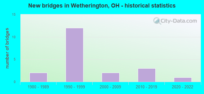
- New bridges - historical statistics
- 21980-1989
- 121990-1999
- 22000-2009
- 32010-2019
- 12020-2022


- Bridge Condition - Deck
- 9.1%Excellent
- 18.2%Very good
- 54.5%Good
- 9.1%Satisfactory
- 9.1%Fair

- Bridge Condition - Superstructure
- 9.1%Excellent
- 18.2%Very good
- 63.6%Good
- 9.1%Serious

- Bridge Condition - Substructure
- 9.1%Excellent
- 18.2%Very good
- 36.4%Good
- 36.4%Satisfactory

- Bridge Condition - Channel
- 12.5%Excellent
- 12.5%Very good
- 37.5%Good
- 37.5%Satisfactory

- Bridge Condition - Culverts
- 66.7%Excellent
- 33.3%Good
Find on map >> Show street view
Structure Number: 901733, Location: 5.35 MI NO OF HAM/BUT (Lat: 39.354650, Lng: -84.374311), Route carried "on" structure: County highway 20, Year Built: 1994, Status: Open, Structure Length: 12.65m (41.50ft), Average Daily Traffic: 41,207 (year 2016), Truck Traffic: 2%, Average Future Daily Traffic: 57,195 (year 2036), Design Load: HS 20+Mod, Features Intersected: IR-75, Facility Carried by Structure: TYLERSVILLE RD CR-
Minimum Vertical Clearance: 30+ m (98+ ft), Kilometerpoint: 16.676, Lanes on structure: 5, Lanes under structure: 6, Owner: State Highway Agency, Approaching Roadway Width: 29.3m (96.1ft), Skew: 2 degrees, Material/Design: Prestressed concrete continuous, Design/Construction: Box Beam or Girders - Multiple, Number Of Spans In Main Unit: 6, Length of Maximum Span: 23.2m (76.1ft), Curb-To-Curb Width: 28.0m (91.9ft), Out-to-Out Width: 29.4m (96.5ft)
Condition: Deck: Good, Superstructure: Good, Substructure: Good, Operating Rating: 67.4 metric tons, Method Used To Determine Operating Rating: Load Factor (LF) rating reported by rating factor (RF) method using MS18 loading, Inventory Rating: 32.4 metric tons, Method Used To Determine Inventory Rating: Load Factor (LF) rating reported by rating factor (RF) method using MS18 loading, Structural Evaluation: Better than present minimum criteria, Deck Geometry: Superior to present desirable criteria, Underclear: Meets minimum limits, Approach Roadway Alignment: Equal to present desirable criteria, Designated Inspection Frequency: Every 24 months, Inspection Date: March 2021, Deck Structure Type: Concrete Cast-file-Place, Wearing Surface/Protective System: Wearing Surface: Integral Concrete, Deck Protection: Epoxy Coated Reinforcing
Find on map >> Show street view
Structure Number: 901784, Location: 6.44 N. HAM-BUT CO LINE (Lat: 39.369269, Lng: -84.366519), Route carried "on" structure: County highway T3370, Year Built: 1998, Year Reconstructed: 2009, Status: Open, Structure Length: 10.16m (33.33ft), Average Daily Traffic: 7,320 (year 1998), Truck Traffic: 4%, Average Future Daily Traffic: 10,160 (year 2018), Design Load: HS 20+Mod, Features Intersected: IR 75, Facility Carried by Structure: LIBERTY WAY TR-337
Minimum Vertical Clearance: 30+ m (98+ ft), Kilometerpoint: 1.600, Lanes on structure: 5, Lanes under structure: 6, Owner: State Highway Agency, Approaching Roadway Width: 14.4m (47.2ft), Material/Design: Steel continuous, Design/Construction: Stringer/Multi-beam, Number Of Spans In Main Unit: 2, Length of Maximum Span: 50.5m (165.7ft), Curb-To-Curb Width: 25.6m (84.0ft), Out-to-Out Width: 26.5m (86.9ft)
Condition: Deck: Satisfactory, Superstructure: Good, Substructure: Good, Operating Rating: 42.1 metric tons, Method Used To Determine Operating Rating: Load Factor (LF) rating reported by rating factor (RF) method using MS18 loading, Inventory Rating: 32.4 metric tons, Method Used To Determine Inventory Rating: Load Factor (LF) rating reported by rating factor (RF) method using MS18 loading, Structural Evaluation: Better than present minimum criteria, Deck Geometry: Superior to present desirable criteria, Underclear: High priority of corrective action, Approach Roadway Alignment: Equal to present desirable criteria, Designated Inspection Frequency: Every 12 months, Inspection Date: March 2021, Deck Structure Type: Concrete Cast-file-Place, Wearing Surface/Protective System: Wearing Surface: Monolithic Concrete, Deck Protection: Epoxy Coated Reinforcing
Find on map >> Show street view
Structure Number: 901792, Location: I 75 RAMP HAM MASON RD (Lat: 39.368819, Lng: -84.367281), Route carried "on" structure: Ramp Interstate 75, Year Built: 2009, Status: Open, Structure Length: 0.85m (2.79ft), Average Daily Traffic: 1,157 (year 2007), Truck Traffic: 20%, Average Future Daily Traffic: 1,606 (year 2027), Design Load: HS 25 or greater, Features Intersected: ACCESS DRIVE
Minimum Vertical Clearance: 30+ m (98+ ft), Kilometerpoint: 10.300, Lanes on structure: 1, Owner: State Highway Agency, Approaching Roadway Width: 7.6m (24.9ft), Material/Design: Concrete, Design/Construction: Culvert, Number Of Spans In Main Unit: 1, Length of Maximum Span: 8.5m (27.9ft)
Condition: Culverts: Excellent, Operating Rating: 42.1 metric tons, Method Used To Determine Operating Rating: Load Factor (LF) rating reported by rating factor (RF) method using MS18 loading, Inventory Rating: 32.4 metric tons, Method Used To Determine Inventory Rating: Load Factor (LF) rating reported by rating factor (RF) method using MS18 loading, Structural Evaluation: Equal to present desirable criteria, Approach Roadway Alignment: Equal to present minimum criteria, Designated Inspection Frequency: Every 24 months, Inspection Date: March 2021
Find on map >> Show street view
Structure Number: 903612, Location: 2.4 MI. WEST OF I-75 (Lat: 39.378461, Lng: -84.407300), Route carried "on" structure: State highway 129, Year Built: 1999, Status: Open, Structure Length: 42.45m (139.27ft), Average Daily Traffic: 22,708 (year 2015), Truck Traffic: 5%, Average Future Daily Traffic: 31,519 (year 2035), Design Load: HS 20+Mod, Features Intersected: MAUD-HUGHES;NSRR;GREG.CR
Minimum Vertical Clearance: 30+ m (98+ ft), Kilometerpoint: 37.272, Lanes on structure: 2, Lanes under structure: 2, Base Highway Network: Yes, Owner: State Highway Agency, Approaching Roadway Width: 11.4m (37.4ft), Skew: 3 degrees, Material/Design: Steel continuous, Design/Construction: Stringer/Multi-beam, Number Of Spans In Main Unit: 6, Length of Maximum Span: 76.0m (249.3ft), Curb-To-Curb Width: 16.8m (55.1ft), Out-to-Out Width: 17.8m (58.4ft)
Condition: Deck: Good, Superstructure: Good, Substructure: Satisfactory, Channel: Good, Operating Rating: 42.1 metric tons, Method Used To Determine Operating Rating: Load Factor (LF) rating reported by rating factor (RF) method using MS18 loading, Inventory Rating: 32.4 metric tons, Method Used To Determine Inventory Rating: Load Factor (LF) rating reported by rating factor (RF) method using MS18 loading, Structural Evaluation: Equal to present minimum criteria, Deck Geometry: Superior to present desirable criteria, Underclear: High priority of corrective action, Waterway Adequacy: Superior to present desirable criteria, Approach Roadway Alignment: Equal to present desirable criteria, Designated Inspection Frequency: Every 12 months, Inspection Date: May 2021, Deck Structure Type: Concrete Cast-file-Place, Wearing Surface/Protective System: Wearing Surface: Monolithic Concrete, Deck Protection: Epoxy Coated Reinforcing
Find on map >> Show street view
Structure Number: 90362, Location: 2.4 MI. WEST OF I-75 (Lat: 39.378200, Lng: -84.407189), Route carried "on" structure: State highway 129, Year Built: 1999, Status: Open, Structure Length: 42.45m (139.27ft), Average Daily Traffic: 22,708 (year 2015), Truck Traffic: 5%, Average Future Daily Traffic: 31,519 (year 2035), Design Load: HS 20+Mod, Features Intersected: MAUD-HUGHES;NSRR;GREG.CR
Minimum Vertical Clearance: 30+ m (98+ ft), Kilometerpoint: 37.272, Lanes on structure: 2, Lanes under structure: 2, Base Highway Network: Yes, Owner: State Highway Agency, Approaching Roadway Width: 11.4m (37.4ft), Skew: 3 degrees, Material/Design: Steel continuous, Design/Construction: Stringer/Multi-beam, Number Of Spans In Main Unit: 6, Length of Maximum Span: 76.0m (249.3ft), Curb-To-Curb Width: 16.8m (55.1ft), Out-to-Out Width: 17.8m (58.4ft)
Condition: Deck: Good, Superstructure: Good, Substructure: Satisfactory, Channel: Satisfactory, Operating Rating: 42.1 metric tons, Method Used To Determine Operating Rating: Load Factor (LF) rating reported by rating factor (RF) method using MS18 loading, Inventory Rating: 32.4 metric tons, Method Used To Determine Inventory Rating: Load Factor (LF) rating reported by rating factor (RF) method using MS18 loading, Structural Evaluation: Equal to present minimum criteria, Deck Geometry: Superior to present desirable criteria, Underclear: High priority of corrective action, Waterway Adequacy: Superior to present desirable criteria, Approach Roadway Alignment: Equal to present desirable criteria, Designated Inspection Frequency: Every 12 months, Inspection Date: May 2021, Deck Structure Type: Concrete Cast-file-Place, Wearing Surface/Protective System: Wearing Surface: Monolithic Concrete, Deck Protection: Epoxy Coated Reinforcing
Find on map >> Show street view
Structure Number: 903639, Location: 1.0 KM W. OF I-75 (Lat: 39.374219, Lng: -84.382189), Route carried "on" structure: State highway 129, Year Built: 1999, Status: Open, Structure Length: 9.13m (29.95ft), Average Daily Traffic: 23,294 (year 2015), Truck Traffic: 6%, Average Future Daily Traffic: 32,332 (year 2035), Design Load: HS 20+Mod, Features Intersected: CINCINNATI-DAYTON ROAD
Minimum Vertical Clearance: 30+ m (98+ ft), Kilometerpoint: 39.493, Lanes on structure: 3, Lanes under structure: 4, Base Highway Network: Yes, Owner: State Highway Agency, Approaching Roadway Width: 19.2m (63.0ft), Skew: 3 degrees, Material/Design: Prestressed concrete continuous, Design/Construction: Stringer/Multi-beam, Number Of Spans In Main Unit: 3, Length of Maximum Span: 39.3m (128.9ft), Curb-To-Curb Width: 20.4m (66.9ft), Out-to-Out Width: 21.4m (70.2ft)
Condition: Deck: Good, Superstructure: Good, Substructure: Good, Operating Rating: 42.1 metric tons, Method Used To Determine Operating Rating: Load Factor (LF) rating reported by rating factor (RF) method using MS18 loading, Inventory Rating: 32.4 metric tons, Method Used To Determine Inventory Rating: Load Factor (LF) rating reported by rating factor (RF) method using MS18 loading, Structural Evaluation: Better than present minimum criteria, Deck Geometry: Superior to present desirable criteria, Underclear: Equal to present minimum criteria, Approach Roadway Alignment: Equal to present desirable criteria, Designated Inspection Frequency: Every 24 months, Inspection Date: Febuary 2021, Deck Structure Type: Concrete Cast-file-Place, Wearing Surface/Protective System: Wearing Surface: Monolithic Concrete, Deck Protection: Epoxy Coated Reinforcing
Find on map >> Show street view
Structure Number: 903655, Location: 1.0 KM W. OF I-75 (Lat: 39.373981, Lng: -84.382381), Route carried "on" structure: State highway 129, Year Built: 1999, Status: Open, Structure Length: 9.13m (29.95ft), Average Daily Traffic: 23,294 (year 2015), Truck Traffic: 6%, Average Future Daily Traffic: 32,332 (year 2035), Design Load: HS 20+Mod, Features Intersected: CINCINNATI-DAYTON ROAD
Minimum Vertical Clearance: 30+ m (98+ ft), Kilometerpoint: 39.493, Lanes on structure: 2, Lanes under structure: 4, Base Highway Network: Yes, Owner: State Highway Agency, Approaching Roadway Width: 15.6m (51.2ft), Skew: 3 degrees, Material/Design: Prestressed concrete continuous, Design/Construction: Stringer/Multi-beam, Number Of Spans In Main Unit: 3, Length of Maximum Span: 39.3m (128.9ft), Curb-To-Curb Width: 16.8m (55.1ft), Out-to-Out Width: 17.8m (58.4ft)
Condition: Deck: Good, Superstructure: Good, Substructure: Good, Operating Rating: 42.1 metric tons, Method Used To Determine Operating Rating: Load Factor (LF) rating reported by rating factor (RF) method using MS18 loading, Inventory Rating: 32.4 metric tons, Method Used To Determine Inventory Rating: Load Factor (LF) rating reported by rating factor (RF) method using MS18 loading, Structural Evaluation: Better than present minimum criteria, Deck Geometry: Superior to present desirable criteria, Underclear: Equal to present minimum criteria, Approach Roadway Alignment: Equal to present desirable criteria, Designated Inspection Frequency: Every 24 months, Inspection Date: Febuary 2021, Deck Structure Type: Concrete Cast-file-Place, Wearing Surface/Protective System: Wearing Surface: Monolithic Concrete, Deck Protection: Epoxy Coated Reinforcing
Find on map >> Show street view
Structure Number: 930995, Location: 0.15 MI S CR18 (Lat: 39.389039, Lng: -84.383761), Route carried "on" structure: County highway C0134, Year Built: 2017, Status: Open, Structure Length: 0.86m (2.82ft), Average Daily Traffic: 10,080 (year 2014), Truck Traffic: 2%, Average Future Daily Traffic: 13,560 (year 2034), Design Load: HL 93, Features Intersected: HUNTS CREEK, Facility Carried by Structure: Yankee Rd
Minimum Vertical Clearance: 30+ m (98+ ft), Kilometerpoint: 1.986, Lanes on structure: 2, Owner: County Highway Agency, Approaching Roadway Width: 9.8m (32.2ft), Skew: 3 degrees, Material/Design: Concrete, Design/Construction: Culvert, Number Of Spans In Main Unit: 1, Length of Maximum Span: 7.7m (25.3ft)
Condition: Channel: Excellent, Culverts: Excellent, Operating Rating: 61.6 metric tons, Method Used To Determine Operating Rating: Load and Resistance Factor Rating (LRFR) rating reported by rating factor(RF) method using HL-93 loadings, Inventory Rating: 48.6 metric tons, Method Used To Determine Inventory Rating: Load and Resistance Factor Rating (LRFR) rating reported by rating factor(RF) method using HL-93 loadings, Structural Evaluation: Superior to present desirable criteria, Waterway Adequacy: Superior to present desirable criteria, Approach Roadway Alignment: Equal to present desirable criteria, Designated Inspection Frequency: Every 24 months, Inspection Date: April 2020
Find on map >> Show street view
Structure Number: 931013, Location: 0.018 Mi. W of JCT T0138 (Lat: 39.371000, Lng: -84.401361), Route carried "on" structure: County highway T0021, Year Built: 2020, Status: Open, Structure Length: 2.27m (7.45ft), Average Daily Traffic: 7,440 (year 2016), Truck Traffic: 5%, Average Future Daily Traffic: 8,600 (year 2036), Design Load: HL 93, Features Intersected: Gregory Creek, Facility Carried by Structure: Hamilton Mason Rd
Minimum Vertical Clearance: 30+ m (98+ ft), Kilometerpoint: 12.056, Lanes on structure: 4, Owner: County Highway Agency, Approaching Roadway Width: 14.6m (47.9ft), Material/Design: Prestressed concrete, Design/Construction: Stringer/Multi-beam, Number Of Spans In Main Unit: 1, Length of Maximum Span: 21.9m (71.9ft), Curb or Sidewalk Widths: Left: 0.0m, Right: 1.8m (5.9ft), Curb-To-Curb Width: 14.6m (47.9ft), Out-to-Out Width: 17.3m (56.8ft)
Condition: Deck: Excellent, Superstructure: Excellent, Substructure: Excellent, Channel: Very good, Operating Rating: 48.6 metric tons, Method Used To Determine Operating Rating: Load and Resistance Factor Rating (LRFR) rating reported by rating factor(RF) method using HL-93 loadings, Inventory Rating: 35.6 metric tons, Method Used To Determine Inventory Rating: Load and Resistance Factor Rating (LRFR) rating reported by rating factor(RF) method using HL-93 loadings, Structural Evaluation: Superior to present desirable criteria, Deck Geometry: High priority of replacement, Waterway Adequacy: Equal to present desirable criteria, Approach Roadway Alignment: Equal to present minimum criteria, Designated Inspection Frequency: Every 12 months, Inspection Date: November 2021, Deck Structure Type: Concrete Cast-file-Place, Wearing Surface/Protective System: Wearing Surface: Monolithic Concrete, Membrane: Epoxy, Deck Protection: Epoxy Coated Reinforcing
Find on map >> Show street view
Structure Number: 931233, Location: .5 MI N OF CR 19 (Lat: 39.367431, Lng: -84.399769), Route carried "on" structure: County highway T0138, Year Built: 1987, Status: Open, Structure Length: 1.07m (3.51ft), Average Daily Traffic: 646 (year 2015), Truck Traffic: 4%, Average Future Daily Traffic: 897 (year 2035), Design Load: HS 20, Features Intersected: GREGORY CREEK BRANCH, Facility Carried by Structure: MAUDS HUGHES RD
Minimum Vertical Clearance: 30+ m (98+ ft), Kilometerpoint: 0.740, Lanes on structure: 2, Owner: County Highway Agency, Approaching Roadway Width: 7.3m (24.0ft), Skew: 3 degrees, Material/Design: Prestressed concrete, Design/Construction: Box Beam or Girders - Multiple, Number Of Spans In Main Unit: 1, Length of Maximum Span: 10.1m (33.1ft), Curb-To-Curb Width: 7.3m (24.0ft), Out-to-Out Width: 7.3m (24.0ft)
Condition: Deck: Good, Superstructure: Good, Substructure: Satisfactory, Channel: Satisfactory, Operating Rating: 71.3 metric tons, Method Used To Determine Operating Rating: Load Factor (LF) rating reported by rating factor (RF) method using MS18 loading, Inventory Rating: 45.4 metric tons, Method Used To Determine Inventory Rating: Load Factor (LF) rating reported by rating factor (RF) method using MS18 loading, Structural Evaluation: Equal to present minimum criteria, Deck Geometry: Meets minimum limits, Waterway Adequacy: Equal to present desirable criteria, Approach Roadway Alignment: Equal to present minimum criteria, Designated Inspection Frequency: Every 12 months, Inspection Date: November 2021, Deck Structure Type: Concrete Cast-file-Place, Wearing Surface/Protective System: Wearing Surface: Bituminous, Membrane: Preformed Fabric
Find on map >> Show street view
Structure Number: 934755, Location: 1.5 MI W OF YANKEE (Lat: 39.386689, Lng: -84.410689), Route carried "on" structure: County highway C0018, Year Built: 1981, Status: Open, Structure Length: 3.96m (12.99ft), Average Daily Traffic: 7,470 (year 2016), Truck Traffic: 8%, Average Future Daily Traffic: 2,046 (year 2036), Design Load: HS 20+Mod, Features Intersected: GREGORY CREEK, Facility Carried by Structure: PRINCETON
Minimum Vertical Clearance: 30+ m (98+ ft), Kilometerpoint: 11.072, Lanes on structure: 2, Owner: County Highway Agency, Approaching Roadway Width: 11.0m (36.1ft), Skew: 1 degrees, Material/Design: Steel, Design/Construction: Stringer/Multi-beam, Number Of Spans In Main Unit: 3, Length of Maximum Span: 15.2m (49.9ft), Curb-To-Curb Width: 11.0m (36.1ft), Out-to-Out Width: 11.0m (36.1ft)
Condition: Deck: Fair, Superstructure: Serious, Substructure: Satisfactory, Channel: Good, Operating Rating: 42.8 metric tons, Method Used To Determine Operating Rating: Load Factor (LF) rating reported by rating factor (RF) method using MS18 loading, Inventory Rating: 25.6 metric tons, Method Used To Determine Inventory Rating: Load Factor (LF) rating reported by rating factor (RF) method using MS18 loading, Structural Evaluation: High priority of corrective action, Deck Geometry: Meets minimum limits, Waterway Adequacy: Equal to present desirable criteria, Approach Roadway Alignment: Equal to present desirable criteria, Designated Inspection Frequency: Every 12 months, Inspection Date: December 2021, Deck Structure Type: Corrugated Steel, Wearing Surface/Protective System: Wearing Surface: Bituminous
Find on map >> Show street view
Structure Number: 936049, Location: 0.08 MI. NORHT OF C.R. 20 (Lat: 39.358661, Lng: -84.395039), Route carried "on" structure: County highway C0019, Year Built: 2002, Status: Open, Structure Length: 0.85m (2.79ft), Average Daily Traffic: 482 (year 2015), Truck Traffic: 7%, Average Future Daily Traffic: 669 (year 2035), Design Load: HS 20, Features Intersected: GREGORY CREEK, Facility Carried by Structure: COUNTY ROAD 19
Minimum Vertical Clearance: 30+ m (98+ ft), Kilometerpoint: 7.226, Lanes on structure: 5, Owner: County Highway Agency, Approaching Roadway Width: 23.2m (76.1ft), Skew: 1 degrees, Material/Design: Concrete, Design/Construction: Culvert, Number Of Spans In Main Unit: 1, Length of Maximum Span: 8.5m (27.9ft)
Condition: Channel: Good, Culverts: Good, Operating Rating: 81.0 metric tons, Method Used To Determine Operating Rating: Load Factor (LF) rating reported by rating factor (RF) method using MS18 loading, Inventory Rating: 58.3 metric tons, Method Used To Determine Inventory Rating: Load Factor (LF) rating reported by rating factor (RF) method using MS18 loading, Structural Evaluation: Better than present minimum criteria, Waterway Adequacy: Superior to present desirable criteria, Approach Roadway Alignment: Equal to present desirable criteria, Designated Inspection Frequency: Every 24 months, Inspection Date: April 2020
Find on map >> Show street view
Structure Number: 93696, Location: 0.58 MI S of Princeton Rd (Lat: 39.394300, Lng: -84.410419), Route carried "on" structure: County highway T0138, Year Built: 2015, Status: Open, Structure Length: 3.59m (11.78ft), Average Daily Traffic: 983 (year 2015), Truck Traffic: 5%, Average Future Daily Traffic: 1,364 (year 2035), Design Load: HL 93, Features Intersected: MAUDS HUGHES, Facility Carried by Structure: MAUDS HUGHES ROAD
Minimum Vertical Clearance: 30+ m (98+ ft), Kilometerpoint: 4.023, Lanes on structure: 2, Owner: County Highway Agency, Approaching Roadway Width: 9.8m (32.2ft), Skew: 4 degrees, Material/Design: Prestressed concrete, Design/Construction: Stringer/Multi-beam, Number Of Spans In Main Unit: 1, Length of Maximum Span: 34.4m (112.9ft), Curb-To-Curb Width: 9.8m (32.2ft), Out-to-Out Width: 10.7m (35.1ft)
Condition: Deck: Very good, Superstructure: Very good, Substructure: Very good, Operating Rating: 51.8 metric tons, Method Used To Determine Operating Rating: Load and Resistance Factor Rating (LRFR) rating reported by rating factor(RF) method using HL-93 loadings, Inventory Rating: 42.1 metric tons, Method Used To Determine Inventory Rating: Load and Resistance Factor Rating (LRFR) rating reported by rating factor(RF) method using HL-93 loadings, Structural Evaluation: Equal to present desirable criteria, Deck Geometry: Equal to present minimum criteria, Underclear: Equal to present minimum criteria, Approach Roadway Alignment: Equal to present desirable criteria, Designated Inspection Frequency: Every 24 months, Inspection Date: April 2020, Deck Structure Type: Concrete Cast-file-Place, Wearing Surface/Protective System: Wearing Surface: Monolithic Concrete
Find on map >> Show street view
Structure Number: 937207, Location: 0.55 mi. S. CR0018 (Lat: 39.379719, Lng: -84.405461), Route carried "on" structure: County highway T0138, Year Built: 2014, Status: Open, Structure Length: 4.33m (14.21ft), Average Daily Traffic: 983 (year 2015), Truck Traffic: 5%, Average Future Daily Traffic: 1,364 (year 2035), Design Load: HL 93, Features Intersected: GREGORY CRK-MAUDS HUGHES, Facility Carried by Structure: Mauds Hughes Road
Minimum Vertical Clearance: 30+ m (98+ ft), Kilometerpoint: 2.253, Lanes on structure: 2, Owner: County Highway Agency, Approaching Roadway Width: 9.8m (32.2ft), Skew: 5 degrees, Material/Design: Concrete continuous, Design/Construction: Slab, Number Of Spans In Main Unit: 3, Length of Maximum Span: 17.4m (57.1ft), Curb-To-Curb Width: 9.8m (32.2ft), Out-to-Out Width: 9.8m (32.2ft)
Condition: Deck: Very good, Superstructure: Very good, Substructure: Very good, Channel: Satisfactory, Operating Rating: 48.6 metric tons, Method Used To Determine Operating Rating: Load and Resistance Factor Rating (LRFR) rating reported by rating factor(RF) method using HL-93 loadings, Inventory Rating: 38.9 metric tons, Method Used To Determine Inventory Rating: Load and Resistance Factor Rating (LRFR) rating reported by rating factor(RF) method using HL-93 loadings, Structural Evaluation: Equal to present desirable criteria, Deck Geometry: Equal to present minimum criteria, Waterway Adequacy: Better than present minimum criteria, Approach Roadway Alignment: Meets minimum limits, Designated Inspection Frequency: Every 24 months, Inspection Date: April 2020, Deck Structure Type: Concrete Cast-file-Place, Wearing Surface/Protective System: Wearing Surface: Monolithic Concrete, Deck Protection: Epoxy Coated Reinforcing
Find on map >> Show street view
Structure Number: 901733, Location: 5.35 MI NO OF HAM/BUT (Lat: 39.354650, Lng: -84.374311), Route carried "under" structure: Interstate 75, Year Built: 1994, Structure Length: 0. m, Average Daily Traffic: 134,418 (year 2016), Truck Traffic: 21%, Features Intersected: TYLERSVILLE RD CR-20, Facility Carried by Structure: TYLERSVILLE RD CR-
Minimum Vertical Clearance: 5.04m (16.54ft), Kilometerpoint: 8.610, Lanes on structure: 5, Lanes under structure: 6, Material/Design: Prestressed concrete continuous, Design/Construction: Box Beam or Girders - Multiple, Length of Maximum Span: 23.2m (76.1ft)
Find on map >> Show street view
Structure Number: 901784, Location: 6.44 N. HAM-BUT CO LINE (Lat: 39.369269, Lng: -84.366519), Route carried "under" structure: Interstate 75, Year Built: 1998, Structure Length: 0. m, Average Daily Traffic: 129,275 (year 2016), Truck Traffic: 23%, Features Intersected: LIBERTY WAY TR-3370, Facility Carried by Structure: LIBERTY WAY TR-337
Minimum Vertical Clearance: 5.13m (16.83ft), Kilometerpoint: 10.364, Lanes on structure: 5, Lanes under structure: 6, Material/Design: Steel continuous, Design/Construction: Stringer/Multi-beam, Length of Maximum Span: 50.5m (165.7ft)
Find on map >> Show street view
Structure Number: 903612, Location: 2.4 MI. WEST OF I-75 (Lat: 39.378461, Lng: -84.407300), Route carried "under" structure: County highway T-138, Year Built: 1999, Structure Length: 0. m, Average Daily Traffic: 983 (year 2015), Truck Traffic: 5%, Features Intersected: SR 129, Facility Carried by Structure: SR 129
Minimum Vertical Clearance: 17.20m (56.43ft), Kilometerpoint: 20.921, Lanes on structure: 2, Lanes under structure: 2, Material/Design: Steel continuous, Design/Construction: Stringer/Multi-beam, Length of Maximum Span: 76.0m (249.3ft)
Find on map >> Show street view
Structure Number: 90362, Location: 2.4 MI. WEST OF I-75 (Lat: 39.378200, Lng: -84.407189), Route carried "under" structure: County highway T-138, Year Built: 1999, Structure Length: 0. m, Average Daily Traffic: 983 (year 2015), Truck Traffic: 5%, Features Intersected: SR 129, Facility Carried by Structure: SR 129
Minimum Vertical Clearance: 17.20m (56.43ft), Kilometerpoint: 20.921, Lanes on structure: 2, Lanes under structure: 2, Material/Design: Steel continuous, Design/Construction: Stringer/Multi-beam, Length of Maximum Span: 76.0m (249.3ft)
Find on map >> Show street view
Structure Number: 903639, Location: 1.0 KM W. OF I-75 (Lat: 39.374219, Lng: -84.382189), Route carried "under" structure: County highway 19, Year Built: 1999, Structure Length: 0. m, Average Daily Traffic: 1 (year 2000), Truck Traffic: 99%, Features Intersected: SR 129, Facility Carried by Structure: SR 129
Minimum Vertical Clearance: 5.21m (17.09ft), Kilometerpoint: 8.401, Lanes on structure: 3, Lanes under structure: 4, Material/Design: Prestressed concrete continuous, Design/Construction: Stringer/Multi-beam, Length of Maximum Span: 39.3m (128.9ft)
Find on map >> Show street view
Structure Number: 903655, Location: 1.0 KM W. OF I-75 (Lat: 39.373981, Lng: -84.382381), Route carried "under" structure: County highway 19, Year Built: 1999, Structure Length: 0. m, Average Daily Traffic: 1 (year 2000), Truck Traffic: 99%, Features Intersected: SR 129, Facility Carried by Structure: SR 129
Minimum Vertical Clearance: 5.21m (17.09ft), Kilometerpoint: 8.401, Lanes on structure: 2, Lanes under structure: 4, Material/Design: Prestressed concrete continuous, Design/Construction: Stringer/Multi-beam, Length of Maximum Span: 39.3m (128.9ft)