Bridge Statistics for West Portsmouth, Ohio (OH)
Condition, Traffic, Stress, Structural Evaluation, Project Costs
- National Bridge Inventory (NBI) Statistics
- 30Number of bridges
- 210ft / 63.9mTotal length
- $555,000Total costs
- 82,209Total average daily traffic
- 4,360Total average daily truck traffic
- National Bridge Inventory (NBI) Registered Bridges for West Portsmouth
- No street view available for this location
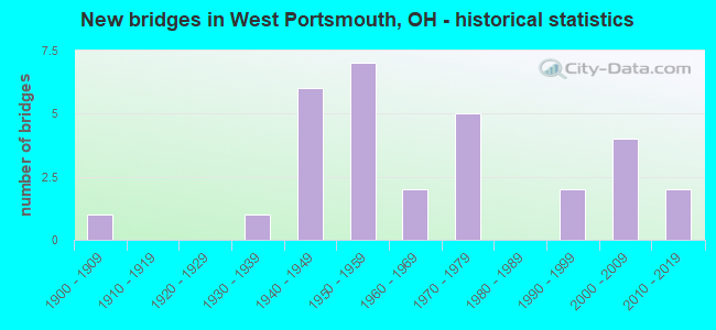
- New bridges - historical statistics
- 11900-1909
- 11930-1939
- 61940-1949
- 71950-1959
- 21960-1969
- 51970-1979
- 21990-1999
- 42000-2009
- 22010-2019

- Reconstructed bridges - Historical Statistics
- 21960-1969
- 11970-1979
- 21980-1989
- 31990-1999


- Bridge Condition - Deck
- 3.7%Excellent
- 48.1%Very good
- 7.4%Good
- 33.3%Satisfactory
- 7.4%Fair

- Bridge Condition - Superstructure
- 3.7%Excellent
- 40.7%Very good
- 18.5%Good
- 25.9%Satisfactory
- 11.1%Fair

- Bridge Condition - Substructure
- 7.4%Excellent
- 44.4%Very good
- 18.5%Good
- 18.5%Satisfactory
- 11.1%Fair

- Bridge Condition - Channel
- 3.8%Excellent
- 26.9%Very good
- 15.4%Good
- 19.2%Satisfactory
- 26.9%Poor
- 7.7%Serious
Find on map >> Show street view
Structure Number: 7300905, Location: 1.03 MI W OF SR 239 (Lat: 38.723481, Lng: -83.045481), Route carried "on" structure: US 52, Year Built: 1951, Status: Open, Structure Length: 4.45m (14.60ft), Average Daily Traffic: 11,831 (year 2015), Truck Traffic: 5%, Average Future Daily Traffic: 16,421 (year 2035), Design Load: HS 20, Features Intersected: CAREYS RUN
Minimum Vertical Clearance: 30+ m (98+ ft), Kilometerpoint: 25.910, Lanes on structure: 4, Base Highway Network: Yes, Owner: State Highway Agency, Approaching Roadway Width: 21.9m (71.9ft), Skew: 20 degrees, Material/Design: Steel continuous, Design/Construction: Stringer/Multi-beam, Number Of Spans In Main Unit: 3, Length of Maximum Span: 15.9m (52.2ft), Curb-To-Curb Width: 21.3m (69.9ft), Out-to-Out Width: 21.9m (71.9ft)
Condition: Deck: Satisfactory, Superstructure: Satisfactory, Substructure: Fair, Channel: Very good, Operating Rating: 42.1 metric tons, Method Used To Determine Operating Rating: Allowable Stress (AS) rating reported by rating factor (RF) method using MS18 loading, Inventory Rating: 32.4 metric tons, Method Used To Determine Inventory Rating: Allowable Stress (AS) rating reported by rating factor (RF) method using MS18 loading, Structural Evaluation: Somewhat better than minimum adequacy, Deck Geometry: Superior to present desirable criteria, Waterway Adequacy: Equal to present desirable criteria, Approach Roadway Alignment: Equal to present desirable criteria, Designated Inspection Frequency: Every 12 months, Inspection Date: December 2021, Deck Structure Type: Concrete Cast-file-Place, Wearing Surface/Protective System: Wearing Surface: Integral Concrete
Find on map >> Show street view
Structure Number: 7300964, Location: JCT SR 239 (Lat: 38.736139, Lng: -83.035231), Route carried "on" structure: US 52, Year Built: 1950, Year Reconstructed: 1972, Status: Open, Structure Length: 4.05m (13.29ft), Average Daily Traffic: 4,254 (year 2015), Truck Traffic: 5%, Average Future Daily Traffic: 5,905 (year 2035), Design Load: HS 20, Features Intersected: SR 239
Minimum Vertical Clearance: 30+ m (98+ ft), Kilometerpoint: 27.568, Lanes on structure: 2, Lanes under structure: 2, Base Highway Network: Yes, Owner: State Highway Agency, Approaching Roadway Width: 11.0m (36.1ft), Material/Design: Steel continuous, Design/Construction: Stringer/Multi-beam, Number Of Spans In Main Unit: 3, Length of Maximum Span: 14.6m (47.9ft), Curb-To-Curb Width: 9.1m (29.9ft), Out-to-Out Width: 11.0m (36.1ft)
Condition: Deck: Satisfactory, Superstructure: Good, Substructure: Good, Operating Rating: 42.1 metric tons, Method Used To Determine Operating Rating: Allowable Stress (AS) rating reported by rating factor (RF) method using MS18 loading, Inventory Rating: 32.4 metric tons, Method Used To Determine Inventory Rating: Allowable Stress (AS) rating reported by rating factor (RF) method using MS18 loading, Structural Evaluation: Better than present minimum criteria, Deck Geometry: Meets minimum limits, Underclear: Equal to present minimum criteria, Approach Roadway Alignment: Superior to present desirable criteria, Designated Inspection Frequency: Every 12 months, Inspection Date: December 2021, Deck Structure Type: Concrete Cast-file-Place, Wearing Surface/Protective System: Wearing Surface: Integral Concrete
Find on map >> Show street view
Structure Number: 7300999, Location: JCT SR 239 (Lat: 38.735989, Lng: -83.035131), Route carried "on" structure: US 52, Year Built: 1972, Status: Open, Structure Length: 4.42m (14.50ft), Average Daily Traffic: 4,254 (year 2015), Truck Traffic: 5%, Average Future Daily Traffic: 5,905 (year 2035), Design Load: HS 20, Features Intersected: SR 239
Minimum Vertical Clearance: 30+ m (98+ ft), Kilometerpoint: 27.568, Lanes on structure: 2, Lanes under structure: 2, Base Highway Network: Yes, Owner: State Highway Agency, Approaching Roadway Width: 12.8m (42.0ft), Material/Design: Steel continuous, Design/Construction: Stringer/Multi-beam, Number Of Spans In Main Unit: 3, Length of Maximum Span: 16.8m (55.1ft), Curb-To-Curb Width: 11.7m (38.4ft), Out-to-Out Width: 12.9m (42.3ft)
Condition: Deck: Very good, Superstructure: Very good, Substructure: Excellent, Operating Rating: 42.1 metric tons, Method Used To Determine Operating Rating: Allowable Stress (AS) rating reported by rating factor (RF) method using MS18 loading, Inventory Rating: 32.4 metric tons, Method Used To Determine Inventory Rating: Allowable Stress (AS) rating reported by rating factor (RF) method using MS18 loading, Structural Evaluation: Equal to present desirable criteria, Deck Geometry: Better than present minimum criteria, Underclear: Equal to present minimum criteria, Approach Roadway Alignment: Equal to present desirable criteria, Designated Inspection Frequency: Every 24 months, Inspection Date: October 2020, Deck Structure Type: Concrete Cast-file-Place, Wearing Surface/Protective System: Wearing Surface: Integral Concrete
Find on map >> Show street view
Structure Number: 7301022, Location: W. BOUND RAMP (Lat: 38.737400, Lng: -83.034211), Route carried "on" structure: Ramp US 52, Year Built: 1972, Status: Open, Structure Length: 6.10m (20.01ft), Average Daily Traffic: 7,550 (year 1990), Average Future Daily Traffic: 10,479 (year 2010), Design Load: HS 20, Features Intersected: LOUSY RUN
Minimum Vertical Clearance: 30+ m (98+ ft), Kilometerpoint: 27.681, Lanes on structure: 1, Owner: State Highway Agency, Approaching Roadway Width: 8.5m (27.9ft), Material/Design: Steel continuous, Design/Construction: Stringer/Multi-beam, Number Of Spans In Main Unit: 3, Length of Maximum Span: 22.9m (75.1ft), Curb-To-Curb Width: 8.5m (27.9ft), Out-to-Out Width: 8.5m (27.9ft)
Condition: Deck: Very good, Superstructure: Very good, Substructure: Very good, Channel: Very good, Operating Rating: 42.1 metric tons, Method Used To Determine Operating Rating: Allowable Stress (AS) rating reported by rating factor (RF) method using MS18 loading, Inventory Rating: 32.4 metric tons, Method Used To Determine Inventory Rating: Allowable Stress (AS) rating reported by rating factor (RF) method using MS18 loading, Structural Evaluation: Equal to present desirable criteria, Deck Geometry: Superior to present desirable criteria, Waterway Adequacy: Equal to present desirable criteria, Approach Roadway Alignment: Equal to present desirable criteria, Designated Inspection Frequency: Every 24 months, Inspection Date: October 2020, Deck Structure Type: Concrete Cast-file-Place, Wearing Surface/Protective System: Wearing Surface: Integral Concrete
Find on map >> Show street view
Structure Number: 7301057, Location: .07 MI E OF SR 239 (Lat: 38.736619, Lng: -83.034131), Route carried "on" structure: US 52, Year Built: 1950, Year Reconstructed: 1972, Status: Open, Structure Length: 6.00m (19.69ft), Average Daily Traffic: 4,254 (year 2015), Truck Traffic: 5%, Average Future Daily Traffic: 5,905 (year 2035), Design Load: HS 20, Features Intersected: LOUSY RUN
Minimum Vertical Clearance: 30+ m (98+ ft), Kilometerpoint: 27.681, Lanes on structure: 2, Base Highway Network: Yes, Owner: State Highway Agency, Approaching Roadway Width: 11.0m (36.1ft), Material/Design: Steel continuous, Design/Construction: Stringer/Multi-beam, Number Of Spans In Main Unit: 3, Length of Maximum Span: 21.9m (71.9ft), Curb-To-Curb Width: 9.1m (29.9ft), Out-to-Out Width: 11.0m (36.1ft)
Condition: Deck: Good, Superstructure: Very good, Substructure: Very good, Channel: Very good, Operating Rating: 42.1 metric tons, Method Used To Determine Operating Rating: Allowable Stress (AS) rating reported by rating factor (RF) method using MS18 loading, Inventory Rating: 32.4 metric tons, Method Used To Determine Inventory Rating: Allowable Stress (AS) rating reported by rating factor (RF) method using MS18 loading, Structural Evaluation: Equal to present desirable criteria, Deck Geometry: Meets minimum limits, Waterway Adequacy: Equal to present desirable criteria, Approach Roadway Alignment: Superior to present desirable criteria, Designated Inspection Frequency: Every 24 months, Inspection Date: October 2020, Deck Structure Type: Concrete Cast-file-Place, Wearing Surface/Protective System: Wearing Surface: Latex Concrete
Find on map >> Show street view
Structure Number: 7301081, Location: 1.86MI W OF PORTSMOUTH (Lat: 38.736450, Lng: -83.034061), Route carried "on" structure: US 52, Year Built: 1972, Status: Open, Structure Length: 6.10m (20.01ft), Average Daily Traffic: 4,254 (year 2015), Truck Traffic: 5%, Average Future Daily Traffic: 5,905 (year 2035), Design Load: HS 20, Features Intersected: LOUSY RUN
Minimum Vertical Clearance: 30+ m (98+ ft), Kilometerpoint: 27.681, Lanes on structure: 2, Base Highway Network: Yes, Owner: State Highway Agency, Approaching Roadway Width: 12.2m (40.0ft), Material/Design: Steel continuous, Design/Construction: Stringer/Multi-beam, Number Of Spans In Main Unit: 3, Length of Maximum Span: 22.9m (75.1ft), Curb-To-Curb Width: 12.2m (40.0ft), Out-to-Out Width: 12.2m (40.0ft)
Condition: Deck: Very good, Superstructure: Very good, Substructure: Very good, Channel: Very good, Operating Rating: 42.1 metric tons, Method Used To Determine Operating Rating: Allowable Stress (AS) rating reported by rating factor (RF) method using MS18 loading, Inventory Rating: 32.4 metric tons, Method Used To Determine Inventory Rating: Allowable Stress (AS) rating reported by rating factor (RF) method using MS18 loading, Structural Evaluation: Equal to present desirable criteria, Deck Geometry: Better than present minimum criteria, Waterway Adequacy: Equal to present desirable criteria, Approach Roadway Alignment: Equal to present desirable criteria, Designated Inspection Frequency: Every 24 months, Inspection Date: October 2020, Deck Structure Type: Concrete Cast-file-Place, Wearing Surface/Protective System: Wearing Surface: Integral Concrete
Find on map >> Show street view
Structure Number: 7301111, Location: 1.86MI W OF PORTSMOUTH (Lat: 38.736231, Lng: -83.033811), Route carried "on" structure: Ramp US 52, Year Built: 1972, Status: Open, Structure Length: 4.02m (13.19ft), Average Daily Traffic: 7,550 (year 1990), Average Future Daily Traffic: 10,479 (year 2010), Design Load: HS 20, Features Intersected: LOUSY RUN
Minimum Vertical Clearance: 30+ m (98+ ft), Kilometerpoint: 27.681, Lanes on structure: 1, Owner: State Highway Agency, Approaching Roadway Width: 8.5m (27.9ft), Material/Design: Steel continuous, Design/Construction: Stringer/Multi-beam, Number Of Spans In Main Unit: 3, Length of Maximum Span: 15.2m (49.9ft), Curb-To-Curb Width: 8.5m (27.9ft), Out-to-Out Width: 8.5m (27.9ft)
Condition: Deck: Good, Superstructure: Good, Substructure: Very good, Channel: Satisfactory, Operating Rating: 42.1 metric tons, Method Used To Determine Operating Rating: Allowable Stress (AS) rating reported by rating factor (RF) method using MS18 loading, Inventory Rating: 32.4 metric tons, Method Used To Determine Inventory Rating: Allowable Stress (AS) rating reported by rating factor (RF) method using MS18 loading, Structural Evaluation: Better than present minimum criteria, Deck Geometry: Superior to present desirable criteria, Waterway Adequacy: High priority of corrective action, Approach Roadway Alignment: Equal to present desirable criteria, Designated Inspection Frequency: Every 24 months, Inspection Date: March 2021, Deck Structure Type: Concrete Cast-file-Place, Wearing Surface/Protective System: Wearing Surface: Integral Concrete
Find on map >> Show street view
Structure Number: 7302797, Location: .69 MI E OF SR 104 (Lat: 38.793531, Lng: -83.014850), Route carried "on" structure: State highway 73, Year Built: 1957, Year Reconstructed: 1996, Status: Open, Structure Length: 1.04m (3.41ft), Average Daily Traffic: 7,910 (year 2015), Truck Traffic: 9%, Average Future Daily Traffic: 10,979 (year 2035), Design Load: HS 15, Features Intersected: POND CREEK
Minimum Vertical Clearance: 30+ m (98+ ft), Kilometerpoint: 33.828, Lanes on structure: 2, Owner: State Highway Agency, Approaching Roadway Width: 13.7m (44.9ft), Skew: 2 degrees, Material/Design: Steel, Design/Construction: Culvert, Number Of Spans In Main Unit: 2, Length of Maximum Span: 4.6m (15.1ft)
Condition: Channel: Satisfactory, Culverts: Satisfactory, Operating Rating: 42.1 metric tons, Method Used To Determine Operating Rating: Load Factor (LF) rating reported by rating factor (RF) method using MS18 loading, Inventory Rating: 32.4 metric tons, Method Used To Determine Inventory Rating: Load Factor (LF) rating reported by rating factor (RF) method using MS18 loading, Structural Evaluation: Equal to present minimum criteria, Waterway Adequacy: Equal to present desirable criteria, Approach Roadway Alignment: Somewhat better than minimum adequacy, Designated Inspection Frequency: Every 12 months, Inspection Date: November 2021
Find on map >> Show street view
Structure Number: 7302827, Location: 2.12 MI E OF SR 104 (Lat: 38.773111, Lng: -83.014961), Route carried "on" structure: State highway 73, Year Built: 1957, Status: Open, Structure Length: 2.62m (8.60ft), Average Daily Traffic: 11,995 (year 2015), Truck Traffic: 8%, Average Future Daily Traffic: 16,649 (year 2035), Design Load: H 15, Features Intersected: DRY RUN
Minimum Vertical Clearance: 30+ m (98+ ft), Kilometerpoint: 36.178, Lanes on structure: 2, Owner: State Highway Agency, Approaching Roadway Width: 12.2m (40.0ft), Material/Design: Concrete continuous, Design/Construction: Slab, Number Of Spans In Main Unit: 3, Length of Maximum Span: 10.1m (33.1ft), Curb-To-Curb Width: 13.0m (42.7ft), Out-to-Out Width: 13.4m (44.0ft)
Condition: Deck: Satisfactory, Superstructure: Satisfactory, Substructure: Satisfactory, Channel: Good, Operating Rating: 42.1 metric tons, Method Used To Determine Operating Rating: Load Factor (LF) rating reported by rating factor (RF) method using MS18 loading, Inventory Rating: 25.9 metric tons, Method Used To Determine Inventory Rating: Load Factor (LF) rating reported by rating factor (RF) method using MS18 loading, Structural Evaluation: Equal to present minimum criteria, Deck Geometry: Somewhat better than minimum adequacy, Waterway Adequacy: Better than present minimum criteria, Approach Roadway Alignment: Better than present minimum criteria, Designated Inspection Frequency: Every 12 months, Inspection Date: November 2021, Deck Structure Type: Concrete Cast-file-Place, Wearing Surface/Protective System: Wearing Surface: Bituminous, Membrane: Built-up
Find on map >> Show street view
Structure Number: 7304714, Location: .98 MI N OF US 52 (Lat: 38.747139, Lng: -83.031200), Route carried "on" structure: State highway 239, Year Built: 1949, Status: Open, Structure Length: 4.85m (15.91ft), Average Daily Traffic: 2,944 (year 2015), Truck Traffic: 5%, Average Future Daily Traffic: 4,086 (year 2035), Design Load: HS 20, Features Intersected: SLAB RUN
Minimum Vertical Clearance: 30+ m (98+ ft), Kilometerpoint: 1.577, Lanes on structure: 2, Owner: State Highway Agency, Approaching Roadway Width: 11.0m (36.1ft), Skew: 4 degrees, Material/Design: Steel continuous, Design/Construction: Stringer/Multi-beam, Number Of Spans In Main Unit: 3, Length of Maximum Span: 17.4m (57.1ft), Curb-To-Curb Width: 11.2m (36.7ft), Out-to-Out Width: 11.7m (38.4ft)
Condition: Deck: Fair, Superstructure: Fair, Substructure: Satisfactory, Channel: Good, Operating Rating: 42.1 metric tons, Method Used To Determine Operating Rating: Load Factor (LF) rating reported by rating factor (RF) method using MS18 loading, Inventory Rating: 32.4 metric tons, Method Used To Determine Inventory Rating: Load Factor (LF) rating reported by rating factor (RF) method using MS18 loading, Structural Evaluation: Somewhat better than minimum adequacy, Deck Geometry: Somewhat better than minimum adequacy, Waterway Adequacy: Equal to present desirable criteria, Approach Roadway Alignment: Equal to present minimum criteria, Designated Inspection Frequency: Every 12 months, Inspection Date: November 2021, Deck Structure Type: Concrete Cast-file-Place, Wearing Surface/Protective System: Wearing Surface: Bituminous
Find on map >> Show street view
Structure Number: 7331258, Location: 0.35 MI NW OF US52 (Lat: 38.726261, Lng: -83.050969), Route carried "on" structure: County highway CR049, Year Built: 1940, Status: Open, Structure Length: 0.88m (2.89ft), Average Daily Traffic: 2,339 (year 2015), Truck Traffic: 8%, Average Future Daily Traffic: 3,247 (year 2035), Design Load: HS 20+Mod, Features Intersected: CAREYS RUN RD(CAREYS RUN, Facility Carried by Structure: CAREYS RUN-POND CK
Minimum Vertical Clearance: 30+ m (98+ ft), Kilometerpoint: 0.563, Lanes on structure: 2, Owner: County Highway Agency, Approaching Roadway Width: 6.7m (22.0ft), Skew: 3 degrees, Material/Design: Concrete, Design/Construction: Tee Beam, Number Of Spans In Main Unit: 1, Length of Maximum Span: 8.2m (26.9ft), Curb or Sidewalk Widths: Left: 0.3m (1.0ft), Right: 0.3m (1.0ft), Curb-To-Curb Width: 6.2m (20.3ft), Out-to-Out Width: 6.9m (22.6ft)
Condition: Deck: Satisfactory, Superstructure: Satisfactory, Substructure: Satisfactory, Channel: Poor, Operating Rating: 58.3 metric tons, Method Used To Determine Operating Rating: Load Factor (LF) rating reported by rating factor (RF) method using MS18 loading, Inventory Rating: 35.6 metric tons, Method Used To Determine Inventory Rating: Load Factor (LF) rating reported by rating factor (RF) method using MS18 loading, Structural Evaluation: Equal to present minimum criteria, Deck Geometry: High priority of replacement, Waterway Adequacy: Meets minimum limits, Approach Roadway Alignment: Meets minimum limits, Designated Inspection Frequency: Every 12 months, Inspection Date: December 2021, Deck Structure Type: Concrete Cast-file-Place, Wearing Surface/Protective System: Wearing Surface: Bituminous
Find on map >> Show street view
Structure Number: 7331266, Location: 00.80 MI. N OF SR52 (Lat: 38.730900, Lng: -83.057239), Route carried "on" structure: County highway CR049, Year Built: 1940, Status: Posted for load, Structure Length: 0.98m (3.22ft), Average Daily Traffic: 2,339 (year 2015), Truck Traffic: 8%, Average Future Daily Traffic: 3,247 (year 2035), Design Load: HS 20+Mod, Features Intersected: CAREYS RUN RD(CAREYS RUN, Facility Carried by Structure: CAREYS RUN-POND CK
Minimum Vertical Clearance: 30+ m (98+ ft), Kilometerpoint: 1.320, Lanes on structure: 2, Owner: County Highway Agency, Approaching Roadway Width: 6.7m (22.0ft), Skew: 2 degrees, Material/Design: Concrete, Design/Construction: Tee Beam, Number Of Spans In Main Unit: 1, Length of Maximum Span: 9.1m (29.9ft), Curb-To-Curb Width: 6.1m (20.0ft), Out-to-Out Width: 6.7m (22.0ft)
Condition: Deck: Satisfactory, Superstructure: Satisfactory, Substructure: Fair, Channel: Serious, Operating Rating: 35.6 metric tons, Method Used To Determine Operating Rating: Load Factor (LF) rating reported by rating factor (RF) method using MS18 loading, Inventory Rating: 19.4 metric tons, Method Used To Determine Inventory Rating: Load Factor (LF) rating reported by rating factor (RF) method using MS18 loading, Structural Evaluation: Somewhat better than minimum adequacy, Deck Geometry: High priority of replacement, Waterway Adequacy: Meets minimum limits, Approach Roadway Alignment: Somewhat better than minimum adequacy, Bridge Posting: Required (Relationship of Operating Rating to Maximum Legal Load: 10.0 - 19.9% below), Designated Inspection Frequency: Every 12 months, Inspection Date: December 2021, Deck Structure Type: Concrete Cast-file-Place, Wearing Surface/Protective System: Wearing Surface: Bituminous
Find on map >> Show street view
Structure Number: 7331282, Location: 02.73 MI. N OF SR52 (Lat: 38.745700, Lng: -83.086100), Route carried "on" structure: County highway CR049, Year Built: 1940, Status: Open, Structure Length: 1.01m (3.31ft), Average Daily Traffic: 2,339 (year 2015), Truck Traffic: 8%, Average Future Daily Traffic: 3,247 (year 2035), Design Load: HS 20+Mod, Features Intersected: CAREYS RUN RD(CAREYS RUN, Facility Carried by Structure: CAREYS RUN-POND CK
Minimum Vertical Clearance: 30+ m (98+ ft), Kilometerpoint: 4.377, Lanes on structure: 2, Owner: County Highway Agency, Approaching Roadway Width: 6.7m (22.0ft), Skew: 4 degrees, Material/Design: Concrete, Design/Construction: Tee Beam, Number Of Spans In Main Unit: 1, Length of Maximum Span: 9.4m (30.8ft), Curb-To-Curb Width: 6.1m (20.0ft), Out-to-Out Width: 6.7m (22.0ft)
Condition: Deck: Fair, Superstructure: Fair, Substructure: Fair, Channel: Poor, Operating Rating: 48.6 metric tons, Method Used To Determine Operating Rating: Load Factor (LF) rating reported by rating factor (RF) method using MS18 loading, Inventory Rating: 29.2 metric tons, Method Used To Determine Inventory Rating: Load Factor (LF) rating reported by rating factor (RF) method using MS18 loading, Structural Evaluation: Somewhat better than minimum adequacy, Deck Geometry: High priority of replacement, Waterway Adequacy: High priority of corrective action, Approach Roadway Alignment: Somewhat better than minimum adequacy, Designated Inspection Frequency: Every 12 months, Inspection Date: December 2021, Deck Structure Type: Concrete Cast-file-Place, Wearing Surface/Protective System: Wearing Surface: Bituminous
Find on map >> Show street view
Structure Number: 7332645, Location: 01.65 MI. E OF CR49 (Lat: 38.779831, Lng: -83.049881), Route carried "on" structure: County highway CR057, Year Built: 1965, Year Reconstructed: 1992, Status: Open, Structure Length: 0.85m (2.79ft), Average Daily Traffic: 495 (year 2015), Truck Traffic: 7%, Average Future Daily Traffic: 687 (year 2035), Features Intersected: DRY RUN RD (DRY RUN), Facility Carried by Structure: DRY RUN ROAD
Minimum Vertical Clearance: 30+ m (98+ ft), Kilometerpoint: 3.251, Lanes on structure: 2, Owner: County Highway Agency, Approaching Roadway Width: 5.8m (19.0ft), Skew: 4 degrees, Material/Design: Concrete, Design/Construction: Tee Beam, Number Of Spans In Main Unit: 1, Length of Maximum Span: 7.9m (25.9ft), Curb-To-Curb Width: 6.4m (21.0ft), Out-to-Out Width: 6.4m (21.0ft)
Condition: Deck: Very good, Superstructure: Very good, Substructure: Good, Channel: Poor, Operating Rating: 64.8 metric tons, Method Used To Determine Operating Rating: Load Factor (LF) rating reported by rating factor (RF) method using MS18 loading, Inventory Rating: 38.9 metric tons, Method Used To Determine Inventory Rating: Load Factor (LF) rating reported by rating factor (RF) method using MS18 loading, Structural Evaluation: Better than present minimum criteria, Deck Geometry: High priority of corrective action, Waterway Adequacy: Meets minimum limits, Approach Roadway Alignment: Meets minimum limits, Designated Inspection Frequency: Every 24 months, Inspection Date: December 2021, Deck Structure Type: Concrete Cast-file-Place, Wearing Surface/Protective System: Wearing Surface: Bituminous
Find on map >> Show street view
Structure Number: 7333641, Location: 00.25 MI. N OF CR126 (Lat: 38.750661, Lng: -83.034289), Route carried "on" structure: County highway TR147, Year Built: 1940, Year Reconstructed: 1975, Status: Posted for load, Structure Length: 0.82m (2.69ft), Average Daily Traffic: 226 (year 2015), Truck Traffic: 5%, Average Future Daily Traffic: 314 (year 2035), Design Load: HS 20+Mod, Features Intersected: HYGEAN RUN RD (HYGEAN RU, Facility Carried by Structure: HYGEAN RUN ROAD
Minimum Vertical Clearance: 30+ m (98+ ft), Kilometerpoint: 0.354, Lanes on structure: 2, Owner: County Highway Agency, Approaching Roadway Width: 5.5m (18.0ft), Skew: 4 degrees, Material/Design: Steel, Design/Construction: Stringer/Multi-beam, Number Of Spans In Main Unit: 1, Length of Maximum Span: 7.3m (24.0ft), Curb-To-Curb Width: 6.7m (22.0ft), Out-to-Out Width: 7.3m (24.0ft)
Condition: Deck: Very good, Superstructure: Satisfactory, Substructure: Good, Channel: Poor, Operating Rating: 22.7 metric tons, Method Used To Determine Operating Rating: Load Factor (LF) rating reported by rating factor (RF) method using MS18 loading, Inventory Rating: 13.0 metric tons, Method Used To Determine Inventory Rating: Load Factor (LF) rating reported by rating factor (RF) method using MS18 loading, Structural Evaluation: Meets minimum limits, Deck Geometry: Meets minimum limits, Waterway Adequacy: Better than present minimum criteria, Approach Roadway Alignment: Equal to present minimum criteria, Bridge Posting: Required (Relationship of Operating Rating to Maximum Legal Load: 30.0 - 39.9% below), Designated Inspection Frequency: Every 12 months, Inspection Date: December 2021, Deck Structure Type: Corrugated Steel, Wearing Surface/Protective System: Wearing Surface: Bituminous
Find on map >> Show street view
Structure Number: 7334737, Location: 00.12 MI S OF CR49 (Lat: 38.785939, Lng: -83.080589), Route carried "on" structure: County highway TR319, Year Built: 1960, Year Reconstructed: 1994, Status: Open, Structure Length: 1.52m (4.99ft), Average Daily Traffic: 146 (year 2015), Truck Traffic: 8%, Average Future Daily Traffic: 203 (year 2035), Features Intersected: SPRADLIN RD (POND CREEK), Facility Carried by Structure: SPRADLIN ROAD
Minimum Vertical Clearance: 30+ m (98+ ft), Kilometerpoint: 0.225, Lanes on structure: 1, Owner: County Highway Agency, Approaching Roadway Width: 3.0m (9.8ft), Material/Design: Steel, Design/Construction: Stringer/Multi-beam, Number Of Spans In Main Unit: 1, Length of Maximum Span: 14.0m (45.9ft), Curb-To-Curb Width: 4.9m (16.1ft), Out-to-Out Width: 4.9m (16.1ft)
Condition: Deck: Very good, Superstructure: Good, Substructure: Good, Channel: Good, Operating Rating: 74.5 metric tons, Method Used To Determine Operating Rating: Allowable Stress (AS) rating reported by rating factor (RF) method using MS18 loading, Inventory Rating: 51.8 metric tons, Method Used To Determine Inventory Rating: Allowable Stress (AS) rating reported by rating factor (RF) method using MS18 loading, Structural Evaluation: Better than present minimum criteria, Deck Geometry: High priority of replacement, Waterway Adequacy: Meets minimum limits, Approach Roadway Alignment: Meets minimum limits, Designated Inspection Frequency: Every 24 months, Inspection Date: December 2021, Deck Structure Type: Corrugated Steel, Wearing Surface/Protective System: Wearing Surface: Bituminous
Find on map >> Show street view
Structure Number: 7335032, Location: 00.01 MI. N OF CR49 (Lat: 38.794739, Lng: -83.070361), Route carried "on" structure: County highway TR418, Year Built: 1959, Year Reconstructed: 1998, Status: Posted for load, Structure Length: 1.86m (6.10ft), Average Daily Traffic: 26 (year 2015), Truck Traffic: 8%, Average Future Daily Traffic: 36 (year 2035), Features Intersected: SWORDS ROAD (POND CREEK), Facility Carried by Structure: SWORDS ROAD
Minimum Vertical Clearance: 30+ m (98+ ft), Kilometerpoint: 0.016, Lanes on structure: 1, Owner: County Highway Agency, Approaching Roadway Width: 5.5m (18.0ft), Material/Design: Steel, Design/Construction: Truss - Thru, Number Of Spans In Main Unit: 1, Length of Maximum Span: 16.8m (55.1ft), Curb-To-Curb Width: 4.1m (13.5ft), Out-to-Out Width: 4.8m (15.7ft)
Condition: Deck: Satisfactory, Superstructure: Fair, Substructure: Good, Channel: Good, Operating Rating: 19.4 metric tons, Method Used To Determine Operating Rating: Load Factor (LF) rating reported by rating factor (RF) method using MS18 loading, Inventory Rating: 9.7 metric tons, Method Used To Determine Inventory Rating: Load Factor (LF) rating reported by rating factor (RF) method using MS18 loading, Structural Evaluation: High priority of replacement, Deck Geometry: Somewhat better than minimum adequacy, Waterway Adequacy: Better than present minimum criteria, Approach Roadway Alignment: Somewhat better than minimum adequacy, Bridge Posting: Required (Relationship of Operating Rating to Maximum Legal Load: > 39.9% below), Length Of Structure Improvement: 1.86m (6.10ft), Designated Inspection Frequency: Every 12 months, Critical Feature Inspection Frequency: Every 24 months, Inspection Date: December 2021, Critical Feature Inspection Date: December 2021, Bridge Improvement Cost: $98,000, Roadway Improvement Cost: $10,000, Total Project Cost: $122,000, Deck Structure Type: Wood or Timber, Wearing Surface/Protective System: Wearing Surface: Bituminous
Find on map >> Show street view
Structure Number: 7335059, Location: 00.52 MI. S OF CR49 (Lat: 38.779389, Lng: -83.094831), Route carried "on" structure: County highway TR450, Year Built: 1940, Status: Posted for load, Structure Length: 0.98m (3.22ft), Average Daily Traffic: 50 (year 2015), Truck Traffic: 8%, Average Future Daily Traffic: 69 (year 2035), Design Load: HS 20+Mod, Features Intersected: MERSHON RD (POND CREEK), Facility Carried by Structure: MERSHON ROAD
Minimum Vertical Clearance: 30+ m (98+ ft), Kilometerpoint: 0.225, Lanes on structure: 1, Owner: County Highway Agency, Approaching Roadway Width: 4.9m (16.1ft), Skew: 3 degrees, Material/Design: Steel, Design/Construction: Stringer/Multi-beam, Number Of Spans In Main Unit: 1, Length of Maximum Span: 9.1m (29.9ft), Curb or Sidewalk Widths: Left: 0.3m (1.0ft), Right: 0.3m (1.0ft), Curb-To-Curb Width: 4.4m (14.4ft), Out-to-Out Width: 4.6m (15.1ft)
Condition: Deck: Satisfactory, Superstructure: Good, Substructure: Satisfactory, Channel: Poor, Operating Rating: 35.6 metric tons, Method Used To Determine Operating Rating: Load Factor (LF) rating reported by rating factor (RF) method using MS18 loading, Inventory Rating: 22.7 metric tons, Method Used To Determine Inventory Rating: Load Factor (LF) rating reported by rating factor (RF) method using MS18 loading, Structural Evaluation: Equal to present minimum criteria, Deck Geometry: Equal to present minimum criteria, Waterway Adequacy: Equal to present minimum criteria, Approach Roadway Alignment: Equal to present minimum criteria, Bridge Posting: Required (Relationship of Operating Rating to Maximum Legal Load: 20.0 - 29.9% below), Length Of Structure Improvement: 0.98m (3.22ft), Designated Inspection Frequency: Every 12 months, Inspection Date: December 2021, Bridge Improvement Cost: $52,000, Roadway Improvement Cost: $5,000, Total Project Cost: $64,000, Deck Structure Type: Wood or Timber, Wearing Surface/Protective System: Wearing Surface: Bituminous
Find on map >> Show street view
Structure Number: 7336039, Location: 00.90 MI. N OF SR239 (Lat: 38.745600, Lng: -83.048500), Route carried "on" structure: County highway CR126, Year Built: 1937, Status: Posted for load, Structure Length: 0.91m (2.99ft), Average Daily Traffic: 101 (year 2015), Truck Traffic: 7%, Average Future Daily Traffic: 140 (year 2035), Design Load: H 15, Features Intersected: SLAB RUN ROAD (SLAB RUN), Facility Carried by Structure: SLAB RUN RD
Minimum Vertical Clearance: 30+ m (98+ ft), Kilometerpoint: 1.609, Lanes on structure: 2, Owner: County Highway Agency, Approaching Roadway Width: 5.5m (18.0ft), Skew: 4 degrees, Material/Design: Concrete continuous, Design/Construction: Slab, Number Of Spans In Main Unit: 2, Length of Maximum Span: 4.0m (13.1ft), Curb-To-Curb Width: 6.7m (22.0ft), Out-to-Out Width: 7.3m (24.0ft)
Condition: Deck: Satisfactory, Superstructure: Satisfactory, Substructure: Satisfactory, Channel: Serious, Operating Rating: 32.4 metric tons, Method Used To Determine Operating Rating: Load Factor (LF) rating reported by rating factor (RF) method using MS18 loading, Inventory Rating: 19.4 metric tons, Method Used To Determine Inventory Rating: Load Factor (LF) rating reported by rating factor (RF) method using MS18 loading, Structural Evaluation: Somewhat better than minimum adequacy, Deck Geometry: Meets minimum limits, Waterway Adequacy: Meets minimum limits, Approach Roadway Alignment: Meets minimum limits, Bridge Posting: Required (Relationship of Operating Rating to Maximum Legal Load: 20.0 - 29.9% below), Designated Inspection Frequency: Every 12 months, Inspection Date: December 2021, Deck Structure Type: Concrete Cast-file-Place, Wearing Surface/Protective System: Wearing Surface: Bituminous
Find on map >> Show street view
Structure Number: 7336934, Location: 0.25 MI E OF TR146 (Lat: 38.777489, Lng: -83.033769), Route carried "on" structure: County highway CR057, Year Built: 2013, Status: Open, Structure Length: 0.94m (3.08ft), Average Daily Traffic: 495 (year 2015), Truck Traffic: 7%, Average Future Daily Traffic: 687 (year 2035), Design Load: HL 93, Features Intersected: DRY RUN RD (DRY RUN), Facility Carried by Structure: DRY RUN-POND CK RD
Minimum Vertical Clearance: 30+ m (98+ ft), Kilometerpoint: 1.786, Lanes on structure: 2, Owner: County Highway Agency, Approaching Roadway Width: 6.1m (20.0ft), Skew: 4 degrees, Material/Design: Concrete, Design/Construction: Frame, Number Of Spans In Main Unit: 1, Length of Maximum Span: 8.8m (28.9ft), Curb-To-Curb Width: 7.3m (24.0ft), Out-to-Out Width: 20.7m (67.9ft)
Condition: Deck: Excellent, Superstructure: Excellent, Substructure: Excellent, Channel: Excellent, Operating Rating: 84.2 metric tons, Method Used To Determine Operating Rating: Load and Resistance Factor Rating (LRFR) rating reported by rating factor(RF) method using HL-93 loadings, Inventory Rating: 64.8 metric tons, Method Used To Determine Inventory Rating: Load and Resistance Factor Rating (LRFR) rating reported by rating factor(RF) method using HL-93 loadings, Structural Evaluation: Superior to present desirable criteria, Deck Geometry: Meets minimum limits, Waterway Adequacy: Equal to present desirable criteria, Approach Roadway Alignment: Equal to present desirable criteria, Designated Inspection Frequency: Every 24 months, Inspection Date: December 2021, Deck Structure Type: Concrete Cast-file-Place, Wearing Surface/Protective System: Wearing Surface: Bituminous
Find on map >> Show street view
Structure Number: 7337108, Location: 0.15 MI. E CR 49 (Lat: 38.779919, Lng: -83.089769), Route carried "on" structure: County highway CR181, Year Built: 1991, Status: Open, Structure Length: 1.83m (6.00ft), Average Daily Traffic: 145 (year 2015), Truck Traffic: 7%, Average Future Daily Traffic: 201 (year 2035), Design Load: HS 20+Mod, Features Intersected: NAUVOO POND CK (POND CK), Facility Carried by Structure: NAUVOO-POND CK RD
Minimum Vertical Clearance: 30+ m (98+ ft), Kilometerpoint: 0.274, Lanes on structure: 2, Owner: County Highway Agency, Approaching Roadway Width: 5.5m (18.0ft), Skew: 3 degrees, Material/Design: Prestressed concrete, Design/Construction: Box Beam or Girders - Multiple, Number Of Spans In Main Unit: 1, Length of Maximum Span: 16.5m (54.1ft), Curb-To-Curb Width: 6.1m (20.0ft), Out-to-Out Width: 6.1m (20.0ft)
Condition: Deck: Satisfactory, Superstructure: Satisfactory, Substructure: Very good, Channel: Very good, Operating Rating: 71.3 metric tons, Method Used To Determine Operating Rating: Load Factor (LF) rating reported by rating factor (RF) method using MS18 loading, Inventory Rating: 42.1 metric tons, Method Used To Determine Inventory Rating: Load Factor (LF) rating reported by rating factor (RF) method using MS18 loading, Structural Evaluation: Equal to present minimum criteria, Deck Geometry: Meets minimum limits, Waterway Adequacy: Better than present minimum criteria, Approach Roadway Alignment: Equal to present minimum criteria, Length Of Structure Improvement: 5.33m (17.49ft), Designated Inspection Frequency: Every 12 months, Inspection Date: December 2021, Bridge Improvement Cost: $66,000, Roadway Improvement Cost: $3,000, Total Project Cost: $69,000, Deck Structure Type: Concrete Cast-file-Place, Wearing Surface/Protective System: Wearing Surface: Bituminous
Find on map >> Show street view
Structure Number: 733731, Location: 00.10 MI. N OF SR52 (Lat: 38.724069, Lng: -83.047731), Route carried "on" structure: County highway CR049, Year Built: 1990, Status: Open, Structure Length: 1.01m (3.31ft), Average Daily Traffic: 2,339 (year 2015), Truck Traffic: 8%, Average Future Daily Traffic: 3,247 (year 2035), Design Load: HS 20+Mod, Features Intersected: CAREYS RUN RD(CAREYS RUN, Facility Carried by Structure: CAREYS RUN-POND CK
Minimum Vertical Clearance: 30+ m (98+ ft), Kilometerpoint: 0.177, Lanes on structure: 2, Owner: County Highway Agency, Approaching Roadway Width: 8.2m (26.9ft), Skew: 1 degrees, Material/Design: Prestressed concrete, Design/Construction: Box Beam or Girders - Multiple, Number Of Spans In Main Unit: 1, Length of Maximum Span: 8.5m (27.9ft), Curb-To-Curb Width: 9.1m (29.9ft), Out-to-Out Width: 9.1m (29.9ft)
Condition: Deck: Very good, Superstructure: Good, Substructure: Very good, Channel: Satisfactory, Operating Rating: 42.1 metric tons, Method Used To Determine Operating Rating: Load Factor (LF) rating reported by rating factor (RF) method using MS18 loading, Inventory Rating: 32.4 metric tons, Method Used To Determine Inventory Rating: Load Factor (LF) rating reported by rating factor (RF) method using MS18 loading, Structural Evaluation: Better than present minimum criteria, Deck Geometry: Meets minimum limits, Waterway Adequacy: Better than present minimum criteria, Approach Roadway Alignment: Better than present minimum criteria, Length Of Structure Improvement: 6.10m (20.01ft), Designated Inspection Frequency: Every 24 months, Inspection Date: December 2021, Bridge Improvement Cost: $100,000, Roadway Improvement Cost: $10,000, Total Project Cost: $300,000, Deck Structure Type: Concrete Cast-file-Place, Wearing Surface/Protective System: Wearing Surface: Bituminous
Find on map >> Show street view
Structure Number: 7337566, Location: 0.25 MI. S OF SR 73 (Lat: 38.805869, Lng: -83.029139), Route carried "on" structure: County highway TR417, Year Built: 2000, Status: Open, Structure Length: 1.43m (4.69ft), Average Daily Traffic: 40 (year 2015), Truck Traffic: 8%, Average Future Daily Traffic: 56 (year 2035), Design Load: HS 20+Mod, Features Intersected: PRIMROSE LN (POND CREEK), Facility Carried by Structure: PRIMROSE LANE
Minimum Vertical Clearance: 30+ m (98+ ft), Kilometerpoint: 0.402, Lanes on structure: 2, Owner: County Highway Agency, Approaching Roadway Width: 5.5m (18.0ft), Material/Design: Prestressed concrete, Design/Construction: Box Beam or Girders - Multiple, Number Of Spans In Main Unit: 1, Length of Maximum Span: 13.4m (44.0ft), Curb-To-Curb Width: 5.5m (18.0ft), Out-to-Out Width: 5.5m (18.0ft)
Condition: Deck: Very good, Superstructure: Very good, Substructure: Very good, Channel: Satisfactory, Operating Rating: 42.1 metric tons, Method Used To Determine Operating Rating: Load Factor (LF) rating reported by rating factor (RF) method using MS18 loading, Inventory Rating: 32.4 metric tons, Method Used To Determine Inventory Rating: Load Factor (LF) rating reported by rating factor (RF) method using MS18 loading, Structural Evaluation: Equal to present desirable criteria, Deck Geometry: Meets minimum limits, Waterway Adequacy: Equal to present desirable criteria, Approach Roadway Alignment: Equal to present desirable criteria, Designated Inspection Frequency: Every 24 months, Inspection Date: December 2021, Deck Structure Type: Concrete Cast-file-Place, Wearing Surface/Protective System: Wearing Surface: Bituminous, Membrane: Built-up
Find on map >> Show street view
Structure Number: 7337949, Location: 0.34 MI N OF CR 126 (Lat: 38.752119, Lng: -83.034889), Route carried "on" structure: County highway TR147, Year Built: 2000, Status: Open, Structure Length: 0.91m (2.99ft), Average Daily Traffic: 226 (year 2015), Truck Traffic: 5%, Average Future Daily Traffic: 314 (year 2035), Design Load: HS 20, Features Intersected: HYGEAN RUN RD (HYGEAN RU, Facility Carried by Structure: HYGEAN RUN ROAD
Minimum Vertical Clearance: 30+ m (98+ ft), Kilometerpoint: 0.547, Lanes on structure: 2, Owner: County Highway Agency, Approaching Roadway Width: 5.5m (18.0ft), Skew: 4 degrees, Material/Design: Concrete, Design/Construction: Tee Beam, Number Of Spans In Main Unit: 1, Length of Maximum Span: 7.6m (24.9ft), Curb-To-Curb Width: 5.5m (18.0ft), Out-to-Out Width: 5.5m (18.0ft)
Condition: Deck: Very good, Superstructure: Very good, Substructure: Very good, Channel: Poor, Operating Rating: 42.1 metric tons, Method Used To Determine Operating Rating: Load Factor (LF) rating reported by rating factor (RF) method using MS18 loading, Inventory Rating: 32.4 metric tons, Method Used To Determine Inventory Rating: Load Factor (LF) rating reported by rating factor (RF) method using MS18 loading, Structural Evaluation: Equal to present desirable criteria, Deck Geometry: High priority of corrective action, Waterway Adequacy: Equal to present desirable criteria, Approach Roadway Alignment: Equal to present minimum criteria, Designated Inspection Frequency: Every 24 months, Inspection Date: December 2021, Deck Structure Type: Concrete Cast-file-Place, Wearing Surface/Protective System: Wearing Surface: Bituminous, Membrane: Built-up
Find on map >> Show street view
Structure Number: 7338414, Location: 5.85 MI N OF US52 (Lat: 38.779339, Lng: -83.108911), Route carried "on" structure: County highway CR049, Year Built: 2008, Status: Open, Structure Length: 0.91m (2.99ft), Average Daily Traffic: 153 (year 2015), Truck Traffic: 8%, Average Future Daily Traffic: 212 (year 2035), Design Load: HS 20, Features Intersected: CAREYS RUN RD (POND CRK), Facility Carried by Structure: CAREYS RUN ROAD
Minimum Vertical Clearance: 30+ m (98+ ft), Kilometerpoint: 9.415, Lanes on structure: 2, Owner: County Highway Agency, Approaching Roadway Width: 5.8m (19.0ft), Skew: 2 degrees, Material/Design: Concrete, Design/Construction: Tee Beam, Number Of Spans In Main Unit: 1, Length of Maximum Span: 8.5m (27.9ft), Curb-To-Curb Width: 7.3m (24.0ft), Out-to-Out Width: 7.3m (24.0ft)
Condition: Deck: Very good, Superstructure: Very good, Substructure: Very good, Channel: Very good, Operating Rating: 42.1 metric tons, Method Used To Determine Operating Rating: Load Factor (LF) rating reported by rating factor (RF) method using MS18 loading, Inventory Rating: 32.4 metric tons, Method Used To Determine Inventory Rating: Load Factor (LF) rating reported by rating factor (RF) method using MS18 loading, Structural Evaluation: Equal to present desirable criteria, Deck Geometry: Somewhat better than minimum adequacy, Waterway Adequacy: Equal to present desirable criteria, Approach Roadway Alignment: Better than present minimum criteria, Designated Inspection Frequency: Every 24 months, Inspection Date: December 2021, Deck Structure Type: Concrete Cast-file-Place, Wearing Surface/Protective System: Wearing Surface: Bituminous, Deck Protection: Other
Find on map >> Show street view
Structure Number: 7338996, Location: 7.75 MI. N OF SR 52 (Lat: 38.790119, Lng: -83.078231), Route carried "on" structure: County highway CR049, Year Built: 1900, Year Reconstructed: 2001, Status: Open, Structure Length: 1.55m (5.09ft), Average Daily Traffic: 153 (year 2015), Truck Traffic: 8%, Average Future Daily Traffic: 212 (year 2035), Design Load: HS 20+Mod, Features Intersected: CAREYS RUN RD (POND CRK), Facility Carried by Structure: CAREYS RUN-POND CK
Minimum Vertical Clearance: 30+ m (98+ ft), Kilometerpoint: 12.472, Lanes on structure: 2, Owner: County Highway Agency, Approaching Roadway Width: 5.5m (18.0ft), Material/Design: Prestressed concrete, Design/Construction: Box Beam or Girders - Multiple, Number Of Spans In Main Unit: 1, Length of Maximum Span: 13.7m (44.9ft), Curb-To-Curb Width: 8.5m (27.9ft), Out-to-Out Width: 8.5m (27.9ft)
Condition: Deck: Very good, Superstructure: Very good, Substructure: Very good, Channel: Very good, Operating Rating: 42.1 metric tons, Method Used To Determine Operating Rating: Load Factor (LF) rating reported by rating factor (RF) method using MS18 loading, Inventory Rating: 32.4 metric tons, Method Used To Determine Inventory Rating: Load Factor (LF) rating reported by rating factor (RF) method using MS18 loading, Structural Evaluation: Equal to present desirable criteria, Deck Geometry: Equal to present minimum criteria, Waterway Adequacy: Superior to present desirable criteria, Approach Roadway Alignment: Equal to present minimum criteria, Designated Inspection Frequency: Every 24 months, Inspection Date: December 2021, Deck Structure Type: Concrete Cast-file-Place, Wearing Surface/Protective System: Wearing Surface: Bituminous, Membrane: Built-up, Deck Protection: Galvanized Reinforcing
Find on map >> Show street view
Structure Number: 7339054, Location: 0.10 MI N OF CR49 (Lat: 38.791161, Lng: -83.081061), Route carried "on" structure: County highway TR125, Year Built: 2001, Status: Open, Structure Length: 0.91m (2.99ft), Average Daily Traffic: 157 (year 2015), Truck Traffic: 8%, Average Future Daily Traffic: 218 (year 2035), Design Load: HS 20, Features Intersected: CAVE LICK ROAD (STREAM), Facility Carried by Structure: CAVE LICK ROAD
Minimum Vertical Clearance: 30+ m (98+ ft), Kilometerpoint: 0.161, Lanes on structure: 2, Owner: County Highway Agency, Approaching Roadway Width: 3.7m (12.1ft), Skew: 3 degrees, Material/Design: Concrete, Design/Construction: Tee Beam, Number Of Spans In Main Unit: 1, Length of Maximum Span: 7.9m (25.9ft), Curb-To-Curb Width: 5.5m (18.0ft), Out-to-Out Width: 5.5m (18.0ft)
Condition: Deck: Very good, Superstructure: Very good, Substructure: Very good, Channel: Poor, Operating Rating: 42.1 metric tons, Method Used To Determine Operating Rating: Load Factor (LF) rating reported by rating factor (RF) method using MS18 loading, Inventory Rating: 32.4 metric tons, Method Used To Determine Inventory Rating: Load Factor (LF) rating reported by rating factor (RF) method using MS18 loading, Structural Evaluation: Equal to present desirable criteria, Deck Geometry: High priority of corrective action, Waterway Adequacy: Superior to present desirable criteria, Approach Roadway Alignment: Equal to present minimum criteria, Designated Inspection Frequency: Every 24 months, Inspection Date: December 2021, Deck Structure Type: Concrete Cast-file-Place, Wearing Surface/Protective System: Wearing Surface: Bituminous, Membrane: Built-up, Deck Protection: Other Coated Reinforcing
Find on map >> Show street view
Structure Number: 7339917, Location: 0.20 MI W OF TR387 (Lat: 38.746550, Lng: -83.088781), Route carried "on" structure: County highway CR049, Year Built: 2010, Status: Open, Structure Length: 0.91m (2.99ft), Average Daily Traffic: 564 (year 2015), Truck Traffic: 7%, Average Future Daily Traffic: 783 (year 2035), Design Load: HS 20+Mod, Features Intersected: CAREYS RUN RD(CAREYS RUN, Facility Carried by Structure: CAREYS RUN
Minimum Vertical Clearance: 30+ m (98+ ft), Kilometerpoint: 4.619, Lanes on structure: 2, Owner: County Highway Agency, Approaching Roadway Width: 5.8m (19.0ft), Skew: 4 degrees, Material/Design: Concrete, Design/Construction: Tee Beam, Number Of Spans In Main Unit: 1, Length of Maximum Span: 7.6m (24.9ft), Curb-To-Curb Width: 7.3m (24.0ft), Out-to-Out Width: 7.3m (24.0ft)
Condition: Deck: Very good, Superstructure: Very good, Substructure: Very good, Channel: Satisfactory, Operating Rating: 77.8 metric tons, Method Used To Determine Operating Rating: Load Factor (LF) rating reported by rating factor (RF) method using MS18 loading, Inventory Rating: 48.6 metric tons, Method Used To Determine Inventory Rating: Load Factor (LF) rating reported by rating factor (RF) method using MS18 loading, Structural Evaluation: Equal to present desirable criteria, Deck Geometry: Meets minimum limits, Waterway Adequacy: Better than present minimum criteria, Approach Roadway Alignment: Better than present minimum criteria, Designated Inspection Frequency: Every 24 months, Inspection Date: December 2021, Deck Structure Type: Concrete Cast-file-Place, Wearing Surface/Protective System: Wearing Surface: Bituminous, Deck Protection: Other
Find on map >> Show street view
Structure Number: 7300964, Location: JCT SR 239 (Lat: 38.736139, Lng: -83.035231), Route carried "under" structure: State highway 239, Year Built: 1950, Structure Length: 0. m, Average Daily Traffic: 1,540 (year 2015), Truck Traffic: 5%, Features Intersected: WEST BOUND US 52
Minimum Vertical Clearance: 4.80m (15.75ft), Kilometerpoint: 0.277, Lanes on structure: 2, Lanes under structure: 2, Material/Design: Steel continuous, Design/Construction: Stringer/Multi-beam, Length of Maximum Span: 14.6m (47.9ft)
Find on map >> Show street view
Structure Number: 7300999, Location: JCT SR 239 (Lat: 38.735989, Lng: -83.035131), Route carried "under" structure: State highway 239, Year Built: 1972, Structure Length: 0. m, Average Daily Traffic: 1,540 (year 2015), Truck Traffic: 5%, Features Intersected: E.B. US 52
Minimum Vertical Clearance: 4.65m (15.26ft), Kilometerpoint: 0.256, Lanes on structure: 2, Lanes under structure: 2, Material/Design: Steel continuous, Design/Construction: Stringer/Multi-beam, Length of Maximum Span: 16.8m (55.1ft)