Bridge Statistics for Wells, Nevada (NV)
Condition, Traffic, Stress, Structural Evaluation, Project Costs
- National Bridge Inventory (NBI) Statistics
- 34Number of bridges
- 338ft / 103mTotal length
- $750,000Total costs
- 113,830Total average daily traffic
- 30,472Total average daily truck traffic
- National Bridge Inventory (NBI) Registered Bridges for Wells
- No street view available for this location
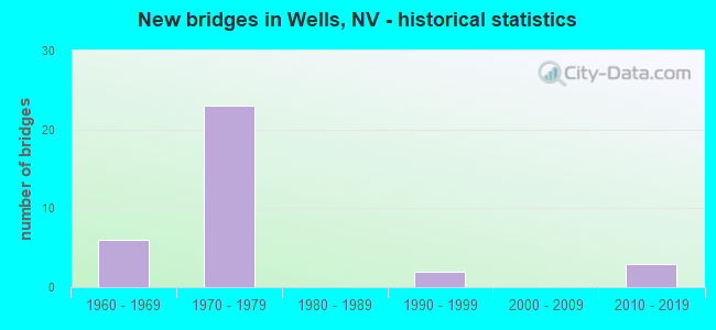
- New bridges - historical statistics
- 61960-1969
- 231970-1979
- 21990-1999
- 32010-2019


- Bridge Condition - Deck
- 66.7%Good
- 33.3%Satisfactory

- Bridge Condition - Superstructure
- 8.3%Very good
- 45.8%Good
- 41.7%Satisfactory
- 4.2%Fair

- Bridge Condition - Substructure
- 70.8%Good
- 29.2%Satisfactory

- Bridge Condition - Culverts
- 50.0%Good
- 50.0%Satisfactory
Find on map >> Show street view
Structure Number: B1438, Location: WELLS (Lat: 41.100228, Lng: -114.959433), Route carried "on" structure: Interstate 80, Year Built: 1977, Status: Open, Structure Length: 0.67m (2.20ft), Average Daily Traffic: 7,300 (year 2017), Truck Traffic: 40%, Average Future Daily Traffic: 7,500 (year 2040), Design Load: HS 20+Mod, Features Intersected: DRY WASH
Minimum Vertical Clearance: 30+ m (98+ ft), Kilometerpoint: 566.833, Lanes on structure: 6, Owner: State Highway Agency, Approaching Roadway Width: 35.4m (116.1ft), Skew: 20 degrees, Material/Design: Concrete, Design/Construction: Culvert, Number Of Spans In Main Unit: 2, Length of Maximum Span: 3.0m (9.8ft)
Condition: Channel: Good, Culverts: Satisfactory, Operating Rating: 61.0 metric tons, Method Used To Determine Operating Rating: Load Factor (LF), Inventory Rating: 36.6 metric tons, Method Used To Determine Inventory Rating: Load Factor (LF), Structural Evaluation: Equal to present minimum criteria, Waterway Adequacy: Equal to present desirable criteria, Approach Roadway Alignment: Equal to present desirable criteria, Designated Inspection Frequency: Every 48 months, Inspection Date: August 2020
Find on map >> Show street view
Structure Number: B2937, Location: NORTH OF WELLS (Lat: 41.195031, Lng: -114.866044), Route carried "on" structure: US 93, Year Built: 2010, Status: Open, Structure Length: 0.82m (2.69ft), Average Daily Traffic: 2,800 (year 2017), Truck Traffic: 25%, Average Future Daily Traffic: 4,000 (year 2040), Design Load: HS 25 or greater, Features Intersected: WILDLIFE UNDERPASS
Minimum Vertical Clearance: 30+ m (98+ ft), Kilometerpoint: 132.283, Lanes on structure: 2, Base Highway Network: Yes, Owner: State Highway Agency, Approaching Roadway Width: 9.7m (31.8ft), Material/Design: Steel, Design/Construction: Culvert, Number Of Spans In Main Unit: 1, Length of Maximum Span: 8.2m (26.9ft)
Condition: Culverts: Good, Inventory Rating: 86.4 metric tons, Method Used To Determine Inventory Rating: Load Factor (LF), Structural Evaluation: Better than present minimum criteria, Waterway Adequacy: Equal to present desirable criteria, Approach Roadway Alignment: Equal to present desirable criteria, Designated Inspection Frequency: Every 48 months, Inspection Date: August 2020
Find on map >> Show street view
Structure Number: G 229, Location: NEAR WELLS (Lat: 41.104725, Lng: -114.953247), Route carried "on" structure: US 93, Year Built: 1992, Status: Open, Structure Length: 4.45m (14.60ft), Average Daily Traffic: 2,800 (year 2017), Truck Traffic: 28%, Average Future Daily Traffic: 4,000 (year 2040), Design Load: HS 20, Features Intersected: SPRR
Minimum Vertical Clearance: 30+ m (98+ ft), Kilometerpoint: 615.096, Lanes on structure: 2, Base Highway Network: Yes, Owner: State Highway Agency, Approaching Roadway Width: 13.4m (44.0ft), Material/Design: Steel continuous, Design/Construction: Stringer/Multi-beam, Number Of Spans In Main Unit: 3, Length of Maximum Span: 21.3m (69.9ft), Curb-To-Curb Width: 13.4m (44.0ft), Out-to-Out Width: 14.3m (46.9ft)
Condition: Deck: Good, Superstructure: Very good, Substructure: Good, Operating Rating: 80.3 metric tons, Method Used To Determine Operating Rating: Load Factor (LF), Inventory Rating: 48.0 metric tons, Method Used To Determine Inventory Rating: Load Factor (LF), Structural Evaluation: Better than present minimum criteria, Deck Geometry: Better than present minimum criteria, Underclear: Better than present minimum criteria, Approach Roadway Alignment: Equal to present desirable criteria, Designated Inspection Frequency: Every 24 months, Inspection Date: August 2020, Bridge Improvement Cost: $500,000, Roadway Improvement Cost: $50,000, Total Project Cost: $750,000, Deck Structure Type: Concrete Cast-file-Place, Wearing Surface/Protective System: Wearing Surface: Bituminous
Find on map >> Show street view
Structure Number: G 323, Location: WELLS (Lat: 41.117103, Lng: -114.974364), Route carried "on" structure: Other road , Year Built: 1995, Status: Open, Structure Length: 5.30m (17.39ft), Average Daily Traffic: 470 (year 2017), Truck Traffic: 4%, Average Future Daily Traffic: 519 (year 2040), Design Load: HS 20+Mod, Features Intersected: UPRR, Facility Carried by Structure: OLD US 40
Minimum Vertical Clearance: 30+ m (98+ ft), Kilometerpoint: 0.360, Lanes on structure: 2, Owner: City or Municipal Highway Agency, Approaching Roadway Width: 11.0m (36.1ft), Material/Design: Steel, Design/Construction: Stringer/Multi-beam, Number Of Spans In Main Unit: 3, Length of Maximum Span: 19.5m (64.0ft), Curb-To-Curb Width: 11.0m (36.1ft), Out-to-Out Width: 11.9m (39.0ft)
Condition: Deck: Satisfactory, Superstructure: Very good, Substructure: Good, Operating Rating: 90.5 metric tons, Method Used To Determine Operating Rating: Load Factor (LF), Inventory Rating: 56.8 metric tons, Method Used To Determine Inventory Rating: Load Factor (LF), Structural Evaluation: Better than present minimum criteria, Deck Geometry: Better than present minimum criteria, Underclear: Superior to present desirable criteria, Approach Roadway Alignment: Equal to present desirable criteria, Designated Inspection Frequency: Every 24 months, Inspection Date: August 2020, Deck Structure Type: Concrete Cast-file-Place, Wearing Surface/Protective System: Wearing Surface: Monolithic Concrete, Deck Protection: Epoxy Coated Reinforcing
Find on map >> Show street view
Structure Number: G 919E, Location: WELLS (Lat: 41.104561, Lng: -114.978761), Route carried "on" structure: Interstate 80, Year Built: 1977, Status: Open, Structure Length: 4.94m (16.21ft), Average Daily Traffic: 3,750 (year 2017), Truck Traffic: 40%, Average Future Daily Traffic: 4,143 (year 2040), Design Load: HS 20+Mod, Features Intersected: UPRR
Minimum Vertical Clearance: 30+ m (98+ ft), Kilometerpoint: 564.931, Lanes on structure: 3, Base Highway Network: Yes, Owner: State Highway Agency, Approaching Roadway Width: 16.5m (54.1ft), Skew: 1 degrees, Material/Design: Steel continuous, Design/Construction: Stringer/Multi-beam, Number Of Spans In Main Unit: 3, Length of Maximum Span: 19.2m (63.0ft), Curb-To-Curb Width: 17.1m (56.1ft), Out-to-Out Width: 17.7m (58.1ft)
Condition: Deck: Good, Superstructure: Satisfactory, Substructure: Good, Operating Rating: 50.2 metric tons, Method Used To Determine Operating Rating: Load Factor (LF), Inventory Rating: 30.0 metric tons, Method Used To Determine Inventory Rating: Load Factor (LF), Structural Evaluation: Equal to present minimum criteria, Deck Geometry: Equal to present minimum criteria, Underclear: Superior to present desirable criteria, Approach Roadway Alignment: Equal to present desirable criteria, Designated Inspection Frequency: Every 24 months, Inspection Date: August 2020, Deck Structure Type: Concrete Cast-file-Place, Wearing Surface/Protective System: Wearing Surface: Bituminous
Find on map >> Show street view
Structure Number: G 919W, Location: WELLS (Lat: 41.104908, Lng: -114.978722), Route carried "on" structure: Interstate 80, Year Built: 1977, Status: Open, Structure Length: 4.94m (16.21ft), Average Daily Traffic: 3,750 (year 2017), Truck Traffic: 40%, Average Future Daily Traffic: 4,143 (year 2040), Design Load: HS 20+Mod, Features Intersected: UPRR
Minimum Vertical Clearance: 30+ m (98+ ft), Kilometerpoint: 564.931, Lanes on structure: 3, Base Highway Network: Yes, Owner: State Highway Agency, Approaching Roadway Width: 19.2m (63.0ft), Skew: 1 degrees, Material/Design: Steel continuous, Design/Construction: Stringer/Multi-beam, Number Of Spans In Main Unit: 3, Length of Maximum Span: 19.2m (63.0ft), Curb-To-Curb Width: 19.5m (64.0ft), Out-to-Out Width: 20.5m (67.3ft)
Condition: Deck: Good, Superstructure: Good, Substructure: Good, Operating Rating: 50.2 metric tons, Method Used To Determine Operating Rating: Load Factor (LF), Inventory Rating: 30.0 metric tons, Method Used To Determine Inventory Rating: Load Factor (LF), Structural Evaluation: Better than present minimum criteria, Deck Geometry: Superior to present desirable criteria, Underclear: Superior to present desirable criteria, Approach Roadway Alignment: Equal to present desirable criteria, Designated Inspection Frequency: Every 24 months, Inspection Date: August 2020, Deck Structure Type: Concrete Cast-file-Place, Wearing Surface/Protective System: Wearing Surface: Bituminous
Find on map >> Show street view
Structure Number: G1296, Location: WELLS (Lat: 41.104092, Lng: -114.978919), Route carried "on" structure: State highway 231, Year Built: 1977, Status: Open, Structure Length: 4.94m (16.21ft), Average Daily Traffic: 910 (year 2017), Truck Traffic: 2%, Average Future Daily Traffic: 1,005 (year 2040), Design Load: HS 20+Mod, Features Intersected: UPRR
Minimum Vertical Clearance: 30+ m (98+ ft), Kilometerpoint: 18.416, Lanes on structure: 2, Owner: State Highway Agency, Approaching Roadway Width: 9.8m (32.2ft), Material/Design: Steel continuous, Design/Construction: Stringer/Multi-beam, Number Of Spans In Main Unit: 3, Length of Maximum Span: 19.2m (63.0ft), Curb-To-Curb Width: 9.8m (32.2ft), Out-to-Out Width: 10.8m (35.4ft)
Condition: Deck: Good, Superstructure: Good, Substructure: Good, Operating Rating: 63.9 metric tons, Method Used To Determine Operating Rating: Load Factor (LF), Inventory Rating: 33.3 metric tons, Method Used To Determine Inventory Rating: Load Factor (LF), Structural Evaluation: Better than present minimum criteria, Deck Geometry: Equal to present minimum criteria, Underclear: Equal to present minimum criteria, Approach Roadway Alignment: Equal to present desirable criteria, Designated Inspection Frequency: Every 24 months, Inspection Date: August 2020, Deck Structure Type: Concrete Cast-file-Place, Wearing Surface/Protective System: Wearing Surface: Bituminous, Membrane: Preformed Fabric
Find on map >> Show street view
Structure Number: H 909E, Location: WEST OF WELLS (Lat: 41.081858, Lng: -115.272597), Route carried "on" structure: Interstate 80, Year Built: 1965, Status: Open, Structure Length: 2.87m (9.42ft), Average Daily Traffic: 3,700 (year 2017), Truck Traffic: 31%, Average Future Daily Traffic: 4,088 (year 2040), Design Load: HS 20+Mod, Features Intersected: CROSS ROAD
Minimum Vertical Clearance: 30+ m (98+ ft), Kilometerpoint: 539.727, Lanes on structure: 2, Lanes under structure: 2, Base Highway Network: Yes, Owner: State Highway Agency, Approaching Roadway Width: 11.9m (39.0ft), Material/Design: Concrete continuous, Design/Construction: Slab, Number Of Spans In Main Unit: 3, Length of Maximum Span: 10.7m (35.1ft), Curb-To-Curb Width: 11.9m (39.0ft), Out-to-Out Width: 12.8m (42.0ft)
Condition: Deck: Satisfactory, Superstructure: Satisfactory, Substructure: Good, Operating Rating: 81.9 metric tons, Method Used To Determine Operating Rating: Load Factor (LF), Inventory Rating: 49.3 metric tons, Method Used To Determine Inventory Rating: Load Factor (LF), Structural Evaluation: Equal to present minimum criteria, Deck Geometry: Equal to present minimum criteria, Underclear: Meets minimum limits, Approach Roadway Alignment: Equal to present desirable criteria, Designated Inspection Frequency: Every 24 months, Inspection Date: August 2020, Deck Structure Type: Concrete Cast-file-Place, Wearing Surface/Protective System: Wearing Surface: Bituminous, Membrane: Other
Find on map >> Show street view
Structure Number: H 917, Location: WEST OF WELLS (Lat: 41.109750, Lng: -115.052147), Route carried "on" structure: Interstate 80, Year Built: 1968, Status: Open, Structure Length: 0.67m (2.20ft), Average Daily Traffic: 8,300 (year 2017), Truck Traffic: 35%, Average Future Daily Traffic: 9,171 (year 2040), Design Load: HS 20+Mod, Features Intersected: CROSS ROAD
Minimum Vertical Clearance: 30+ m (98+ ft), Kilometerpoint: 558.681, Lanes on structure: 4, Lanes under structure: 1, Base Highway Network: Yes, Owner: State Highway Agency, Approaching Roadway Width: 24.3m (79.7ft), Skew: 10 degrees, Material/Design: Concrete, Design/Construction: Frame, Number Of Spans In Main Unit: 1, Length of Maximum Span: 6.1m (20.0ft), Curb-To-Curb Width: 24.3m (79.7ft), Out-to-Out Width: 45.0m (147.6ft)
Condition: Deck: Satisfactory, Superstructure: Satisfactory, Substructure: Satisfactory, Operating Rating: 76.7 metric tons, Method Used To Determine Operating Rating: Load Factor (LF), Inventory Rating: 46.0 metric tons, Method Used To Determine Inventory Rating: Load Factor (LF), Structural Evaluation: Equal to present minimum criteria, Deck Geometry: Superior to present desirable criteria, Underclear: High priority of corrective action, Approach Roadway Alignment: Equal to present desirable criteria, Designated Inspection Frequency: Every 24 months, Inspection Date: August 2020, Deck Structure Type: Concrete Cast-file-Place
Find on map >> Show street view
Structure Number: H1512E, Location: WELLS (Lat: 41.102744, Lng: -114.968283), Route carried "on" structure: Interstate 80, Year Built: 1977, Status: Open, Structure Length: 3.72m (12.20ft), Average Daily Traffic: 3,950 (year 2017), Truck Traffic: 40%, Average Future Daily Traffic: 4,364 (year 2040), Design Load: HS 20+Mod, Features Intersected: SHOSHONE ST
Minimum Vertical Clearance: 30+ m (98+ ft), Kilometerpoint: 565.832, Lanes on structure: 2, Lanes under structure: 2, Base Highway Network: Yes, Owner: State Highway Agency, Approaching Roadway Width: 12.8m (42.0ft), Material/Design: Prestressed concrete, Design/Construction: Box Beam or Girders - Multiple, Number Of Spans In Main Unit: 1, Length of Maximum Span: 36.6m (120.1ft), Curb-To-Curb Width: 12.8m (42.0ft), Out-to-Out Width: 13.9m (45.6ft)
Condition: Deck: Good, Superstructure: Good, Substructure: Good, Inventory Rating: 56.4 metric tons, Method Used To Determine Inventory Rating: Load Factor (LF), Structural Evaluation: Better than present minimum criteria, Deck Geometry: Equal to present desirable criteria, Underclear: Equal to present minimum criteria, Approach Roadway Alignment: Equal to present desirable criteria, Designated Inspection Frequency: Every 24 months, Inspection Date: July 2020, Deck Structure Type: Concrete Cast-file-Place, Wearing Surface/Protective System: Wearing Surface: Bituminous
Find on map >> Show street view
Structure Number: H1512W, Location: WELLS (Lat: 41.103019, Lng: -114.968156), Route carried "on" structure: Interstate 80, Year Built: 1977, Status: Open, Structure Length: 3.72m (12.20ft), Average Daily Traffic: 3,950 (year 2017), Truck Traffic: 40%, Average Future Daily Traffic: 4,364 (year 2040), Design Load: HS 20+Mod, Features Intersected: SHOSHONE ST
Minimum Vertical Clearance: 30+ m (98+ ft), Kilometerpoint: 565.832, Lanes on structure: 2, Lanes under structure: 2, Base Highway Network: Yes, Owner: State Highway Agency, Approaching Roadway Width: 12.7m (41.7ft), Material/Design: Prestressed concrete, Design/Construction: Box Beam or Girders - Multiple, Number Of Spans In Main Unit: 1, Length of Maximum Span: 36.6m (120.1ft), Curb-To-Curb Width: 12.8m (42.0ft), Out-to-Out Width: 13.9m (45.6ft)
Condition: Deck: Good, Superstructure: Good, Substructure: Good, Inventory Rating: 56.4 metric tons, Method Used To Determine Inventory Rating: Load Factor (LF), Structural Evaluation: Better than present minimum criteria, Deck Geometry: Equal to present desirable criteria, Underclear: Equal to present minimum criteria, Approach Roadway Alignment: Equal to present desirable criteria, Designated Inspection Frequency: Every 24 months, Inspection Date: July 2020, Deck Structure Type: Concrete Cast-file-Place, Wearing Surface/Protective System: Wearing Surface: Bituminous
Find on map >> Show street view
Structure Number: I 906W, Location: WEST OF WELLS (Lat: 40.852586, Lng: -115.747453), Route carried "on" structure: Interstate 80, Year Built: 1977, Status: Open, Structure Length: 4.44m (14.57ft), Average Daily Traffic: 6,000 (year 2017), Truck Traffic: 40%, Average Future Daily Traffic: 6,629 (year 2040), Design Load: HS 20+Mod, Features Intersected: SR535 IDAHO ST
Minimum Vertical Clearance: 30+ m (98+ ft), Kilometerpoint: 488.557, Lanes on structure: 2, Lanes under structure: 4, Base Highway Network: Yes, Owner: State Highway Agency, Approaching Roadway Width: 12.0m (39.4ft), Material/Design: Prestressed concrete, Design/Construction: Box Beam or Girders - Multiple, Number Of Spans In Main Unit: 1, Length of Maximum Span: 43.8m (143.7ft), Curb-To-Curb Width: 12.8m (42.0ft), Out-to-Out Width: 13.7m (44.9ft)
Condition: Deck: Good, Superstructure: Good, Substructure: Good, Inventory Rating: 71.8 metric tons, Method Used To Determine Inventory Rating: Load Factor (LF), Structural Evaluation: Better than present minimum criteria, Deck Geometry: Equal to present desirable criteria, Underclear: Meets minimum limits, Approach Roadway Alignment: Equal to present desirable criteria, Designated Inspection Frequency: Every 24 months, Inspection Date: July 2020, Deck Structure Type: Concrete Cast-file-Place, Wearing Surface/Protective System: Wearing Surface: Bituminous
Find on map >> Show street view
Structure Number: I 920E, Location: WELLS (Lat: 41.104119, Lng: -114.974144), Route carried "on" structure: Interstate 80, Year Built: 1977, Status: Open, Structure Length: 4.85m (15.91ft), Average Daily Traffic: 3,750 (year 2017), Truck Traffic: 4%, Average Future Daily Traffic: 4,143 (year 2040), Design Load: HS 20+Mod, Features Intersected: SR223 HUMBOLDT AV
Minimum Vertical Clearance: 30+ m (98+ ft), Kilometerpoint: 565.319, Lanes on structure: 2, Lanes under structure: 4, Base Highway Network: Yes, Owner: State Highway Agency, Approaching Roadway Width: 11.6m (38.1ft), Skew: 1 degrees, Material/Design: Prestressed concrete, Design/Construction: Box Beam or Girders - Single/Spread, Number Of Spans In Main Unit: 1, Length of Maximum Span: 47.9m (157.2ft), Curb-To-Curb Width: 12.8m (42.0ft), Out-to-Out Width: 13.9m (45.6ft)
Condition: Deck: Good, Superstructure: Good, Substructure: Good, Operating Rating: 87.2 metric tons, Method Used To Determine Operating Rating: Load Factor (LF), Inventory Rating: 52.2 metric tons, Method Used To Determine Inventory Rating: Load Factor (LF), Structural Evaluation: Better than present minimum criteria, Deck Geometry: Equal to present desirable criteria, Underclear: Meets minimum limits, Approach Roadway Alignment: Equal to present desirable criteria, Designated Inspection Frequency: Every 24 months, Inspection Date: July 2020, Deck Structure Type: Concrete Cast-file-Place, Wearing Surface/Protective System: Wearing Surface: Bituminous
Find on map >> Show street view
Structure Number: I 920W, Location: WELLS (Lat: 41.104431, Lng: -114.974144), Route carried "on" structure: Interstate 80, Year Built: 1977, Status: Open, Structure Length: 4.85m (15.91ft), Average Daily Traffic: 3,750 (year 2017), Truck Traffic: 3%, Average Future Daily Traffic: 4,143 (year 2040), Design Load: HS 20+Mod, Features Intersected: SR223 HUMBOLDT AV
Minimum Vertical Clearance: 30+ m (98+ ft), Kilometerpoint: 565.319, Lanes on structure: 2, Lanes under structure: 4, Base Highway Network: Yes, Owner: State Highway Agency, Approaching Roadway Width: 11.6m (38.1ft), Skew: 1 degrees, Material/Design: Prestressed concrete, Design/Construction: Box Beam or Girders - Single/Spread, Number Of Spans In Main Unit: 1, Length of Maximum Span: 47.9m (157.2ft), Curb-To-Curb Width: 12.8m (42.0ft), Out-to-Out Width: 13.9m (45.6ft)
Condition: Deck: Good, Superstructure: Satisfactory, Substructure: Good, Operating Rating: 87.2 metric tons, Method Used To Determine Operating Rating: Load Factor (LF), Inventory Rating: 52.2 metric tons, Method Used To Determine Inventory Rating: Load Factor (LF), Structural Evaluation: Equal to present minimum criteria, Deck Geometry: Equal to present desirable criteria, Underclear: Meets minimum limits, Approach Roadway Alignment: Equal to present desirable criteria, Designated Inspection Frequency: Every 24 months, Inspection Date: July 2020, Deck Structure Type: Concrete Cast-file-Place, Wearing Surface/Protective System: Wearing Surface: Bituminous
Find on map >> Show street view
Structure Number: I 921E, Location: WELLS (Lat: 41.099503, Lng: -114.958047), Route carried "on" structure: Interstate 80, Year Built: 1977, Status: Open, Structure Length: 4.60m (15.09ft), Average Daily Traffic: 1,800 (year 2017), Truck Traffic: 40%, Average Future Daily Traffic: 3,000 (year 2040), Design Load: HS 20+Mod, Features Intersected: US 93
Minimum Vertical Clearance: 30+ m (98+ ft), Kilometerpoint: 566.771, Lanes on structure: 2, Lanes under structure: 5, Base Highway Network: Yes, Owner: State Highway Agency, Approaching Roadway Width: 12.8m (42.0ft), Material/Design: Prestressed concrete, Design/Construction: Box Beam or Girders - Single/Spread, Number Of Spans In Main Unit: 1, Length of Maximum Span: 45.4m (149.0ft), Curb-To-Curb Width: 12.8m (42.0ft), Out-to-Out Width: 13.9m (45.6ft)
Condition: Deck: Good, Superstructure: Good, Substructure: Good, Inventory Rating: 74.0 metric tons, Method Used To Determine Inventory Rating: Load Factor (LF), Structural Evaluation: Better than present minimum criteria, Deck Geometry: Equal to present desirable criteria, Underclear: Meets minimum limits, Approach Roadway Alignment: Equal to present desirable criteria, Designated Inspection Frequency: Every 24 months, Inspection Date: July 2020, Deck Structure Type: Concrete Cast-file-Place, Wearing Surface/Protective System: Wearing Surface: Bituminous
Find on map >> Show street view
Structure Number: I 921W, Location: WELLS (Lat: 41.099756, Lng: -114.957900), Route carried "on" structure: Interstate 80, Year Built: 1977, Status: Open, Structure Length: 4.60m (15.09ft), Average Daily Traffic: 2,300 (year 2017), Truck Traffic: 4%, Average Future Daily Traffic: 2,541 (year 2040), Design Load: HS 20+Mod, Features Intersected: US 93
Minimum Vertical Clearance: 30+ m (98+ ft), Kilometerpoint: 566.771, Lanes on structure: 2, Lanes under structure: 5, Base Highway Network: Yes, Owner: State Highway Agency, Approaching Roadway Width: 12.8m (42.0ft), Material/Design: Prestressed concrete, Design/Construction: Box Beam or Girders - Single/Spread, Number Of Spans In Main Unit: 1, Length of Maximum Span: 45.4m (149.0ft), Curb-To-Curb Width: 12.8m (42.0ft), Out-to-Out Width: 13.9m (45.6ft)
Condition: Deck: Good, Superstructure: Good, Substructure: Good, Inventory Rating: 74.0 metric tons, Method Used To Determine Inventory Rating: Load Factor (LF), Structural Evaluation: Better than present minimum criteria, Deck Geometry: Equal to present desirable criteria, Underclear: Meets minimum limits, Approach Roadway Alignment: Equal to present desirable criteria, Designated Inspection Frequency: Every 24 months, Inspection Date: July 2020, Deck Structure Type: Concrete Cast-file-Place, Wearing Surface/Protective System: Wearing Surface: Bituminous
Find on map >> Show street view
Structure Number: I 922E, Location: EAST OF WELLS (Lat: 41.112542, Lng: -114.803361), Route carried "on" structure: Interstate 80, Year Built: 1965, Status: Open, Structure Length: 2.83m (9.28ft), Average Daily Traffic: 2,925 (year 2017), Truck Traffic: 40%, Average Future Daily Traffic: 3,232 (year 2040), Design Load: HS 20, Features Intersected: MOOR EXIT 360
Minimum Vertical Clearance: 30+ m (98+ ft), Kilometerpoint: 579.934, Lanes on structure: 2, Lanes under structure: 2, Base Highway Network: Yes, Owner: State Highway Agency, Approaching Roadway Width: 11.6m (38.1ft), Material/Design: Concrete continuous, Design/Construction: Slab, Number Of Spans In Main Unit: 3, Length of Maximum Span: 10.7m (35.1ft), Curb-To-Curb Width: 11.9m (39.0ft), Out-to-Out Width: 12.8m (42.0ft)
Condition: Deck: Satisfactory, Superstructure: Satisfactory, Substructure: Satisfactory, Operating Rating: 48.3 metric tons, Method Used To Determine Operating Rating: Load Factor (LF), Inventory Rating: 29.0 metric tons, Method Used To Determine Inventory Rating: Load Factor (LF), Structural Evaluation: Equal to present minimum criteria, Deck Geometry: Equal to present minimum criteria, Underclear: High priority of corrective action, Approach Roadway Alignment: Equal to present desirable criteria, Designated Inspection Frequency: Every 24 months, Inspection Date: July 2020, Deck Structure Type: Concrete Cast-file-Place, Wearing Surface/Protective System: Wearing Surface: Other
Find on map >> Show street view
Structure Number: I 922W, Location: EAST OF WELLS (Lat: 41.112889, Lng: -114.803353), Route carried "on" structure: Interstate 80, Year Built: 1965, Status: Open, Structure Length: 2.83m (9.28ft), Average Daily Traffic: 2,925 (year 2017), Truck Traffic: 40%, Average Future Daily Traffic: 3,232 (year 2040), Design Load: HS 20, Features Intersected: MOOR EXIT 360
Minimum Vertical Clearance: 30+ m (98+ ft), Kilometerpoint: 579.934, Lanes on structure: 2, Lanes under structure: 2, Base Highway Network: Yes, Owner: State Highway Agency, Approaching Roadway Width: 11.6m (38.1ft), Material/Design: Concrete continuous, Design/Construction: Slab, Number Of Spans In Main Unit: 3, Length of Maximum Span: 10.7m (35.1ft), Curb-To-Curb Width: 11.9m (39.0ft), Out-to-Out Width: 12.8m (42.0ft)
Condition: Deck: Satisfactory, Superstructure: Satisfactory, Substructure: Satisfactory, Operating Rating: 48.3 metric tons, Method Used To Determine Operating Rating: Load Factor (LF), Inventory Rating: 29.0 metric tons, Method Used To Determine Inventory Rating: Load Factor (LF), Structural Evaluation: Equal to present minimum criteria, Deck Geometry: Equal to present minimum criteria, Underclear: High priority of corrective action, Approach Roadway Alignment: Equal to present desirable criteria, Designated Inspection Frequency: Every 24 months, Inspection Date: July 2020, Deck Structure Type: Concrete Cast-file-Place, Wearing Surface/Protective System: Wearing Surface: Other
Find on map >> Show street view
Structure Number: I 923E, Location: EAST OF WELLS (Lat: 41.090028, Lng: -114.710303), Route carried "on" structure: Interstate 80, Year Built: 1965, Status: Open, Structure Length: 2.83m (9.28ft), Average Daily Traffic: 2,700 (year 2017), Truck Traffic: 40%, Average Future Daily Traffic: 5,550 (year 2040), Design Load: HS 20+Mod, Features Intersected: INDEPENDENCE EXIT365
Minimum Vertical Clearance: 30+ m (98+ ft), Kilometerpoint: 588.270, Lanes on structure: 2, Lanes under structure: 2, Base Highway Network: Yes, Owner: State Highway Agency, Approaching Roadway Width: 12.2m (40.0ft), Material/Design: Concrete continuous, Design/Construction: Slab, Number Of Spans In Main Unit: 3, Length of Maximum Span: 10.7m (35.1ft), Curb-To-Curb Width: 12.2m (40.0ft), Out-to-Out Width: 12.9m (42.3ft)
Condition: Deck: Satisfactory, Superstructure: Satisfactory, Substructure: Satisfactory, Operating Rating: 48.3 metric tons, Method Used To Determine Operating Rating: Load Factor (LF), Inventory Rating: 28.7 metric tons, Method Used To Determine Inventory Rating: Load Factor (LF), Structural Evaluation: Equal to present minimum criteria, Deck Geometry: Better than present minimum criteria, Underclear: Meets minimum limits, Approach Roadway Alignment: Equal to present desirable criteria, Designated Inspection Frequency: Every 24 months, Inspection Date: August 2020, Deck Structure Type: Concrete Cast-file-Place, Wearing Surface/Protective System: Wearing Surface: Other
Find on map >> Show street view
Structure Number: I 923W, Location: EAST OF WELLS (Lat: 41.090339, Lng: -114.710136), Route carried "on" structure: Interstate 80, Year Built: 1965, Status: Open, Structure Length: 2.83m (9.28ft), Average Daily Traffic: 2,700 (year 2017), Truck Traffic: 40%, Average Future Daily Traffic: 5,550 (year 2040), Design Load: HS 20+Mod, Features Intersected: INDEPENDENCE EXIT 365
Minimum Vertical Clearance: 30+ m (98+ ft), Kilometerpoint: 588.270, Lanes on structure: 2, Lanes under structure: 2, Base Highway Network: Yes, Owner: State Highway Agency, Approaching Roadway Width: 12.2m (40.0ft), Material/Design: Concrete continuous, Design/Construction: Slab, Number Of Spans In Main Unit: 3, Length of Maximum Span: 10.7m (35.1ft), Curb-To-Curb Width: 12.2m (40.0ft), Out-to-Out Width: 12.9m (42.3ft)
Condition: Deck: Satisfactory, Superstructure: Satisfactory, Substructure: Satisfactory, Operating Rating: 48.3 metric tons, Method Used To Determine Operating Rating: Load Factor (LF), Inventory Rating: 28.7 metric tons, Method Used To Determine Inventory Rating: Load Factor (LF), Structural Evaluation: Equal to present minimum criteria, Deck Geometry: Better than present minimum criteria, Underclear: Meets minimum limits, Approach Roadway Alignment: Equal to present desirable criteria, Designated Inspection Frequency: Every 24 months, Inspection Date: August 2020, Deck Structure Type: Concrete Cast-file-Place, Wearing Surface/Protective System: Wearing Surface: Other
Find on map >> Show street view
Structure Number: I 926, Location: EAST OF WELLS (Lat: 40.945950, Lng: -114.365508), Route carried "on" structure: ServiceCounty highway , Year Built: 1974, Status: Open, Structure Length: 12.41m (40.72ft), Average Daily Traffic: 100 (year 2017), Truck Traffic: 3%, Average Future Daily Traffic: 100 (year 2040), Design Load: HS 20+Mod, Features Intersected: I 80, Facility Carried by Structure: COUNTY ROAD
Minimum Vertical Clearance: 30+ m (98+ ft), Kilometerpoint: 624.005, Lanes on structure: 2, Lanes under structure: 4, Owner: State Highway Agency, Approaching Roadway Width: 9.1m (29.9ft), Material/Design: Prestressed concrete, Design/Construction: Box Beam or Girders - Multiple, Number Of Spans In Main Unit: 3, Number Of Approach Spans: 2, Length of Maximum Span: 30.5m (100.1ft), Curb-To-Curb Width: 9.8m (32.2ft), Out-to-Out Width: 10.7m (35.1ft)
Condition: Deck: Good, Superstructure: Fair, Substructure: Satisfactory, Operating Rating: 62.0 metric tons, Method Used To Determine Operating Rating: Load Factor (LF), Inventory Rating: 37.2 metric tons, Method Used To Determine Inventory Rating: Load Factor (LF), Structural Evaluation: Somewhat better than minimum adequacy, Deck Geometry: Equal to present desirable criteria, Underclear: Somewhat better than minimum adequacy, Approach Roadway Alignment: Equal to present desirable criteria, Designated Inspection Frequency: Every 24 months, Inspection Date: August 2020, Deck Structure Type: Concrete Cast-file-Place, Wearing Surface/Protective System: Wearing Surface: Bituminous, Membrane: Preformed Fabric
Find on map >> Show street view
Structure Number: I 930W, Location: WEST OF WENDOVER (Lat: 40.843247, Lng: -114.208681), Route carried "on" structure: Interstate 80, Year Built: 1978, Status: Open, Structure Length: 2.93m (9.61ft), Average Daily Traffic: 2,900 (year 2017), Truck Traffic: 40%, Average Future Daily Traffic: 3,204 (year 2040), Design Load: HS 20+Mod, Features Intersected: CROSS ROAD
Minimum Vertical Clearance: 30+ m (98+ ft), Kilometerpoint: 641.943, Lanes on structure: 2, Lanes under structure: 2, Base Highway Network: Yes, Owner: State Highway Agency, Approaching Roadway Width: 11.6m (38.1ft), Material/Design: Concrete continuous, Design/Construction: Slab, Number Of Spans In Main Unit: 3, Length of Maximum Span: 12.8m (42.0ft), Curb-To-Curb Width: 12.8m (42.0ft), Out-to-Out Width: 13.9m (45.6ft)
Condition: Deck: Satisfactory, Superstructure: Satisfactory, Substructure: Satisfactory, Operating Rating: 59.7 metric tons, Method Used To Determine Operating Rating: Load Factor (LF), Inventory Rating: 35.9 metric tons, Method Used To Determine Inventory Rating: Load Factor (LF), Structural Evaluation: Equal to present minimum criteria, Deck Geometry: Equal to present desirable criteria, Underclear: Meets minimum limits, Approach Roadway Alignment: Equal to present desirable criteria, Designated Inspection Frequency: Every 48 months, Inspection Date: July 2020, Deck Structure Type: Concrete Cast-file-Place, Wearing Surface/Protective System: Wearing Surface: Other
Find on map >> Show street view
Structure Number: I1159E, Location: EAST OF WELLS (Lat: 41.061311, Lng: -114.524589), Route carried "on" structure: Interstate 80, Year Built: 1973, Status: Open, Structure Length: 4.57m (14.99ft), Average Daily Traffic: 2,500 (year 2017), Truck Traffic: 40%, Average Future Daily Traffic: 2,762 (year 2040), Design Load: HS 20+Mod, Features Intersected: CROSS ROAD
Minimum Vertical Clearance: 30+ m (98+ ft), Kilometerpoint: 605.430, Lanes on structure: 2, Lanes under structure: 2, Base Highway Network: Yes, Owner: State Highway Agency, Approaching Roadway Width: 12.7m (41.7ft), Skew: 3 degrees, Material/Design: Concrete continuous, Design/Construction: Box Beam or Girders - Multiple, Number Of Spans In Main Unit: 3, Length of Maximum Span: 17.7m (58.1ft), Curb-To-Curb Width: 12.8m (42.0ft), Out-to-Out Width: 13.7m (44.9ft)
Condition: Deck: Good, Superstructure: Satisfactory, Substructure: Good, Operating Rating: 54.8 metric tons, Method Used To Determine Operating Rating: Load Factor (LF), Inventory Rating: 32.9 metric tons, Method Used To Determine Inventory Rating: Load Factor (LF), Structural Evaluation: Equal to present minimum criteria, Deck Geometry: Equal to present desirable criteria, Underclear: Equal to present minimum criteria, Approach Roadway Alignment: Equal to present desirable criteria, Designated Inspection Frequency: Every 48 months, Inspection Date: July 2020, Deck Structure Type: Concrete Cast-file-Place, Wearing Surface/Protective System: Wearing Surface: Other
Find on map >> Show street view
Structure Number: I1159W, Location: EAST OF WELLS (Lat: 41.061775, Lng: -114.523553), Route carried "on" structure: Interstate 80, Year Built: 1973, Status: Open, Structure Length: 4.57m (14.99ft), Average Daily Traffic: 2,500 (year 2017), Truck Traffic: 40%, Average Future Daily Traffic: 2,762 (year 2040), Design Load: HS 20+Mod, Features Intersected: CROSS ROAD
Minimum Vertical Clearance: 30+ m (98+ ft), Kilometerpoint: 605.430, Lanes on structure: 3, Lanes under structure: 2, Base Highway Network: Yes, Owner: State Highway Agency, Approaching Roadway Width: 15.2m (49.9ft), Skew: 3 degrees, Material/Design: Concrete continuous, Design/Construction: Box Beam or Girders - Multiple, Number Of Spans In Main Unit: 3, Length of Maximum Span: 17.7m (58.1ft), Curb-To-Curb Width: 15.2m (49.9ft), Out-to-Out Width: 15.8m (51.8ft)
Condition: Deck: Good, Superstructure: Good, Substructure: Good, Operating Rating: 54.8 metric tons, Method Used To Determine Operating Rating: Load Factor (LF), Inventory Rating: 32.9 metric tons, Method Used To Determine Inventory Rating: Load Factor (LF), Structural Evaluation: Better than present minimum criteria, Deck Geometry: Meets minimum limits, Underclear: Equal to present minimum criteria, Approach Roadway Alignment: Equal to present desirable criteria, Designated Inspection Frequency: Every 48 months, Inspection Date: July 2020, Deck Structure Type: Concrete Cast-file-Place, Wearing Surface/Protective System: Wearing Surface: Other
Find on map >> Show street view
Structure Number: I1511E, Location: WEST OF WELLS (Lat: 41.110881, Lng: -115.039017), Route carried "on" structure: Interstate 80, Year Built: 1977, Status: Open, Structure Length: 3.20m (10.50ft), Average Daily Traffic: 4,150 (year 2017), Truck Traffic: 40%, Average Future Daily Traffic: 4,585 (year 2040), Design Load: HS 20+Mod, Features Intersected: ALAZON RD
Minimum Vertical Clearance: 30+ m (98+ ft), Kilometerpoint: 559.276, Lanes on structure: 2, Lanes under structure: 2, Base Highway Network: Yes, Owner: State Highway Agency, Approaching Roadway Width: 11.6m (38.1ft), Material/Design: Prestressed concrete, Design/Construction: Box Beam or Girders - Multiple, Number Of Spans In Main Unit: 1, Length of Maximum Span: 31.4m (103.0ft), Curb-To-Curb Width: 12.8m (42.0ft), Out-to-Out Width: 13.9m (45.6ft)
Condition: Deck: Good, Superstructure: Good, Substructure: Good, Operating Rating: 89.4 metric tons, Method Used To Determine Operating Rating: Load Factor (LF), Inventory Rating: 53.5 metric tons, Method Used To Determine Inventory Rating: Load Factor (LF), Structural Evaluation: Better than present minimum criteria, Deck Geometry: Equal to present desirable criteria, Underclear: High priority of corrective action, Approach Roadway Alignment: Equal to present desirable criteria, Designated Inspection Frequency: Every 24 months, Inspection Date: July 2020, Deck Structure Type: Concrete Cast-file-Place, Wearing Surface/Protective System: Wearing Surface: Bituminous
Find on map >> Show street view
Structure Number: I1511W, Location: WEST OF WELLS (Lat: 41.111347, Lng: -115.038986), Route carried "on" structure: Interstate 80, Year Built: 1977, Status: Open, Structure Length: 3.20m (10.50ft), Average Daily Traffic: 4,150 (year 2017), Truck Traffic: 40%, Average Future Daily Traffic: 4,585 (year 2040), Design Load: HS 20+Mod, Features Intersected: ALAZON RD
Minimum Vertical Clearance: 30+ m (98+ ft), Kilometerpoint: 559.276, Lanes on structure: 2, Lanes under structure: 2, Base Highway Network: Yes, Owner: State Highway Agency, Approaching Roadway Width: 11.6m (38.1ft), Material/Design: Prestressed concrete, Design/Construction: Box Beam or Girders - Multiple, Number Of Spans In Main Unit: 1, Length of Maximum Span: 31.4m (103.0ft), Curb-To-Curb Width: 12.8m (42.0ft), Out-to-Out Width: 13.9m (45.6ft)
Condition: Deck: Good, Superstructure: Good, Substructure: Good, Operating Rating: 89.4 metric tons, Method Used To Determine Operating Rating: Load Factor (LF), Inventory Rating: 53.5 metric tons, Method Used To Determine Inventory Rating: Load Factor (LF), Structural Evaluation: Better than present minimum criteria, Deck Geometry: Equal to present desirable criteria, Underclear: High priority of corrective action, Approach Roadway Alignment: Equal to present desirable criteria, Designated Inspection Frequency: Every 24 months, Inspection Date: July 2020, Deck Structure Type: Concrete Cast-file-Place, Wearing Surface/Protective System: Wearing Surface: Bituminous
Find on map >> Show street view
Structure Number: I 906W, Location: WEST OF WELLS (Lat: 40.852586, Lng: -115.747453), Route carried "under" structure: State highway 535, Year Built: 1977, Structure Length: 0. m, Average Daily Traffic: 10,700 (year 2009), Truck Traffic: 4%, Features Intersected: SR535 IDAHO ST, Facility Carried by Structure: I 80W
Minimum Vertical Clearance: 5.15m (16.90ft), Kilometerpoint: 488.557, Lanes on structure: 2, Lanes under structure: 4, Material/Design: Prestressed concrete, Design/Construction: Box Beam or Girders - Multiple, Length of Maximum Span: 43.8m (143.7ft)
Find on map >> Show street view
Structure Number: I 920E, Location: WELLS (Lat: 41.104119, Lng: -114.974144), Route carried "under" structure: State highway 223, Year Built: 1977, Structure Length: 0. m, Average Daily Traffic: 1,050 (year 2009), Truck Traffic: 3%, Features Intersected: SR223 HUMBOLDT AV, Facility Carried by Structure: I 80E
Minimum Vertical Clearance: 5.49m (18.01ft), Kilometerpoint: 565.319, Lanes on structure: 2, Lanes under structure: 4, Material/Design: Prestressed concrete, Design/Construction: Box Beam or Girders - Single/Spread, Length of Maximum Span: 47.9m (157.2ft)
Find on map >> Show street view
Structure Number: I 920W, Location: WELLS (Lat: 41.104431, Lng: -114.974144), Route carried "under" structure: State highway 223, Year Built: 1977, Structure Length: 0. m, Average Daily Traffic: 1,050 (year 2009), Truck Traffic: 3%, Features Intersected: SR223 HUMBOLDT AV, Facility Carried by Structure: I 80W
Minimum Vertical Clearance: 5.49m (18.01ft), Kilometerpoint: 565.319, Lanes on structure: 2, Lanes under structure: 4, Material/Design: Prestressed concrete, Design/Construction: Box Beam or Girders - Single/Spread, Length of Maximum Span: 47.9m (157.2ft)
Find on map >> Show street view
Structure Number: I 921E, Location: WELLS (Lat: 41.099503, Lng: -114.958047), Route carried "under" structure: US 93, Year Built: 1977, Structure Length: 0. m, Average Daily Traffic: 3,250 (year 2009), Truck Traffic: 3%, Features Intersected: US 93, Facility Carried by Structure: I 80E
Minimum Vertical Clearance: 5.03m (16.50ft), Kilometerpoint: 566.771, Lanes on structure: 2, Lanes under structure: 5, Material/Design: Prestressed concrete, Design/Construction: Box Beam or Girders - Single/Spread, Length of Maximum Span: 45.4m (149.0ft)
Find on map >> Show street view
Structure Number: I 921W, Location: WELLS (Lat: 41.099756, Lng: -114.957900), Route carried "under" structure: US 93, Year Built: 1977, Structure Length: 0. m, Average Daily Traffic: 3,250 (year 2009), Truck Traffic: 3%, Features Intersected: US 93, Facility Carried by Structure: I 80W
Minimum Vertical Clearance: 5.03m (16.50ft), Kilometerpoint: 566.771, Lanes on structure: 2, Lanes under structure: 5, Material/Design: Prestressed concrete, Design/Construction: Box Beam or Girders - Single/Spread, Length of Maximum Span: 45.4m (149.0ft)
Find on map >> Show street view
Structure Number: I 926, Location: EAST OF WELLS (Lat: 40.945950, Lng: -114.365508), Route carried "under" structure: Interstate 80, Year Built: 1974, Structure Length: 0. m, Average Daily Traffic: 4,900 (year 2009), Truck Traffic: 3%, Features Intersected: I 80, Facility Carried by Structure: COUNTY ROAD
Minimum Vertical Clearance: 5.03m (16.50ft), Kilometerpoint: 624.005, Lanes on structure: 2, Lanes under structure: 4, Material/Design: Prestressed concrete, Design/Construction: Box Beam or Girders - Multiple, Length of Maximum Span: 30.5m (100.1ft)
Find on map >> Show street view
Structure Number: P2934, Location: NORTH OF WELLS (Lat: 41.207669, Lng: -114.850997), Route carried "under" structure: US 93, Year Built: 2010, Structure Length: 0. m, Average Daily Traffic: 1,400 (year 2017), Truck Traffic: 25%, Features Intersected: US 93, Facility Carried by Structure: WILDLIFE OVERPASS
Minimum Vertical Clearance: 6.19m (20.31ft), Kilometerpoint: 134.184, Lanes under structure: 2, Material/Design: Concrete, Design/Construction: Arch - Deck, Length of Maximum Span: 20.0m (65.6ft)
Find on map >> Show street view
Structure Number: P294, Location: NORTH OF WELLS (Lat: 41.348386, Lng: -114.805672), Route carried "under" structure: US 93, Year Built: 2011, Structure Length: 0. m, Average Daily Traffic: 1,400 (year 2017), Truck Traffic: 13%, Features Intersected: US 93, Facility Carried by Structure: WILDLIFE OVERPASS
Minimum Vertical Clearance: 6.68m (21.92ft), Kilometerpoint: 150.347, Lanes under structure: 2, Material/Design: Concrete, Design/Construction: Arch - Deck, Length of Maximum Span: 18.2m (59.7ft)