Bridge Statistics for Welcome, Minnesota (MN)
Condition, Traffic, Stress, Structural Evaluation, Project Costs
- National Bridge Inventory (NBI) Statistics
- 16Number of bridges
- 138ft / 42.5mTotal length
- 41,643Total average daily traffic
- 10,289Total average daily truck traffic
- National Bridge Inventory (NBI) Registered Bridges for Welcome
- No street view available for this location
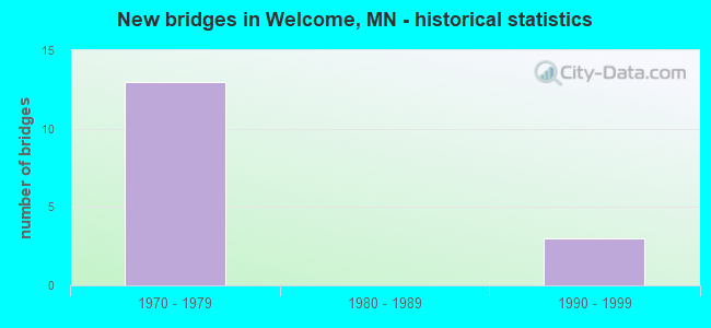
- New bridges - historical statistics
- 131970-1979
- 31990-1999


- Bridge Condition - Deck
- 57.1%Good
- 42.9%Satisfactory

- Bridge Condition - Superstructure
- 85.7%Good
- 14.3%Satisfactory

- Bridge Condition - Substructure
- 85.7%Good
- 14.3%Satisfactory

- Bridge Condition - Channel
- 66.7%Very good
- 16.7%Good
- 16.7%Satisfactory

- Bridge Condition - Culverts
- 25.0%Very good
- 50.0%Good
- 25.0%Satisfactory
Find on map >> Show street view
Structure Number: 46516, Location: 1.1 MI N OF JCT CSAH 32 (Lat: 43.704569, Lng: -94.552156), Route carried "on" structure: County highway 33, Year Built: 1972, Status: Open, Structure Length: 1.93m (6.33ft), Average Daily Traffic: 125 (year 2014), Average Future Daily Traffic: 125 (year 2039), Design Load: HS 20, Features Intersected: LILY CREEK
Minimum Vertical Clearance: 30+ m (98+ ft), Kilometerpoint: 0.000, Lanes on structure: 2, Owner: County Highway Agency, Approaching Roadway Width: 11.0m (36.1ft), Material/Design: Prestressed concrete, Design/Construction: Channel Beam, Number Of Spans In Main Unit: 3, Length of Maximum Span: 7.7m (25.3ft), Curb-To-Curb Width: 10.3m (33.8ft), Out-to-Out Width: 11.6m (38.1ft)
Condition: Deck: Satisfactory, Superstructure: Satisfactory, Substructure: Satisfactory, Channel: Good, Operating Rating: 76.7 metric tons, Method Used To Determine Operating Rating: Load Factor (LF), Inventory Rating: 46.1 metric tons, Method Used To Determine Inventory Rating: Load Factor (LF), Structural Evaluation: Equal to present minimum criteria, Deck Geometry: Better than present minimum criteria, Waterway Adequacy: Equal to present desirable criteria, Approach Roadway Alignment: Equal to present desirable criteria, Designated Inspection Frequency: Every 24 months, Inspection Date: October 2021, Deck Structure Type: Concrete Cast-file-Place, Wearing Surface/Protective System: Wearing Surface: Bituminous
Find on map >> Show street view
Structure Number: 46517, Location: 0.6 MI W OF JCT CSAH 33 (Lat: 43.702897, Lng: -94.566667), Route carried "on" structure: County highway 298, Year Built: 1973, Status: Open, Structure Length: 2.11m (6.92ft), Average Daily Traffic: 40 (year 1986), Average Future Daily Traffic: 40 (year 2029), Design Load: H 20, Features Intersected: LILY CREEK
Minimum Vertical Clearance: 30+ m (98+ ft), Kilometerpoint: 0.000, Lanes on structure: 2, Owner: Town or Township Highway Agency, Approaching Roadway Width: 7.9m (25.9ft), Material/Design: Prestressed concrete, Design/Construction: Channel Beam, Number Of Spans In Main Unit: 3, Length of Maximum Span: 9.4m (30.8ft), Curb-To-Curb Width: 9.0m (29.5ft), Out-to-Out Width: 9.6m (31.5ft)
Condition: Deck: Satisfactory, Superstructure: Good, Substructure: Good, Channel: Satisfactory, Operating Rating: 52.2 metric tons, Method Used To Determine Operating Rating: Field evaluation and documented engineering judgment, Inventory Rating: 32.7 metric tons, Method Used To Determine Inventory Rating: Field evaluation and documented engineering judgment, Structural Evaluation: Better than present minimum criteria, Deck Geometry: Better than present minimum criteria, Waterway Adequacy: Equal to present desirable criteria, Approach Roadway Alignment: Equal to present desirable criteria, Designated Inspection Frequency: Every 24 months, Inspection Date: October 2021, Deck Structure Type: Concrete Cast-file-Place, Wearing Surface/Protective System: Wearing Surface: Gravel
Find on map >> Show street view
Structure Number: 46811, Location: 6.3 MI E OF JCT TH 4 (Lat: 43.681222, Lng: -94.614731), Route carried "on" structure: Interstate 90, Year Built: 1973, Status: Open, Structure Length: 6.19m (20.31ft), Average Daily Traffic: 4,500 (year 2016), Truck Traffic: 22%, Average Future Daily Traffic: 4,500 (year 2039), Design Load: HS 20+Mod, Features Intersected: TH 263
Minimum Vertical Clearance: 30+ m (98+ ft), Kilometerpoint: 0.000, Lanes on structure: 2, Lanes under structure: 2, Base Highway Network: Yes, Owner: State Highway Agency, Approaching Roadway Width: 11.3m (37.1ft), Material/Design: Prestressed concrete, Design/Construction: Stringer/Multi-beam, Number Of Spans In Main Unit: 3, Length of Maximum Span: 26.5m (86.9ft), Curb-To-Curb Width: 12.3m (40.4ft), Out-to-Out Width: 13.5m (44.3ft)
Condition: Deck: Good, Superstructure: Good, Substructure: Good, Operating Rating: 67.4 metric tons, Method Used To Determine Operating Rating: Load Factor (LF), Inventory Rating: 37.7 metric tons, Method Used To Determine Inventory Rating: Load Factor (LF), Structural Evaluation: Better than present minimum criteria, Deck Geometry: Better than present minimum criteria, Underclear: Better than present minimum criteria, Approach Roadway Alignment: Equal to present desirable criteria, Designated Inspection Frequency: Every 24 months, Inspection Date: June 2021, Deck Structure Type: Concrete Cast-file-Place, Wearing Surface/Protective System: Wearing Surface: Low Slump Concrete
Find on map >> Show street view
Structure Number: 46812, Location: 6.3 MI E OF JCT TH 4 (Lat: 43.680992, Lng: -94.614739), Route carried "on" structure: Interstate 90, Year Built: 1973, Status: Open, Structure Length: 6.19m (20.31ft), Average Daily Traffic: 4,089 (year 2019), Truck Traffic: 30%, Average Future Daily Traffic: 4,500 (year 2039), Design Load: HS 20+Mod, Features Intersected: TH 263
Minimum Vertical Clearance: 30+ m (98+ ft), Kilometerpoint: 0.000, Lanes on structure: 2, Lanes under structure: 2, Base Highway Network: Yes, Owner: State Highway Agency, Approaching Roadway Width: 11.3m (37.1ft), Material/Design: Prestressed concrete, Design/Construction: Stringer/Multi-beam, Number Of Spans In Main Unit: 3, Length of Maximum Span: 26.5m (86.9ft), Curb-To-Curb Width: 12.3m (40.4ft), Out-to-Out Width: 13.5m (44.3ft)
Condition: Deck: Good, Superstructure: Good, Substructure: Good, Operating Rating: 67.4 metric tons, Method Used To Determine Operating Rating: Load Factor (LF), Inventory Rating: 37.7 metric tons, Method Used To Determine Inventory Rating: Load Factor (LF), Structural Evaluation: Better than present minimum criteria, Deck Geometry: Better than present minimum criteria, Underclear: Superior to present desirable criteria, Approach Roadway Alignment: Equal to present desirable criteria, Designated Inspection Frequency: Every 24 months, Inspection Date: June 2021, Deck Structure Type: Concrete Cast-file-Place, Wearing Surface/Protective System: Wearing Surface: Low Slump Concrete
Find on map >> Show street view
Structure Number: 46813, Location: 5.3 MI W OF JCT TH 15 (Lat: 43.680806, Lng: -94.552100), Route carried "on" structure: County highway 130, Year Built: 1973, Status: Open, Structure Length: 8.52m (27.95ft), Average Daily Traffic: 2,550 (year 2014), Average Future Daily Traffic: 2,550 (year 2039), Design Load: HS 20, Features Intersected: I 90
Minimum Vertical Clearance: 30+ m (98+ ft), Kilometerpoint: 0.000, Lanes on structure: 2, Lanes under structure: 4, Owner: State Highway Agency, Approaching Roadway Width: 12.2m (40.0ft), Material/Design: Prestressed concrete, Design/Construction: Stringer/Multi-beam, Number Of Spans In Main Unit: 4, Length of Maximum Span: 26.1m (85.6ft), Curb-To-Curb Width: 9.8m (32.2ft), Out-to-Out Width: 10.9m (35.8ft)
Condition: Deck: Good, Superstructure: Good, Substructure: Good, Operating Rating: 62.9 metric tons, Method Used To Determine Operating Rating: Load Factor (LF), Inventory Rating: 32.5 metric tons, Method Used To Determine Inventory Rating: Load Factor (LF), Structural Evaluation: Better than present minimum criteria, Deck Geometry: Meets minimum limits, Underclear: Equal to present minimum criteria, Approach Roadway Alignment: Equal to present desirable criteria, Designated Inspection Frequency: Every 24 months, Inspection Date: September 2020, Deck Structure Type: Concrete Cast-file-Place, Wearing Surface/Protective System: Wearing Surface: Monolithic Concrete
Find on map >> Show street view
Structure Number: 4683, Location: 4.5 MI E OF JCT TH 4 (Lat: 43.669736, Lng: -94.643631), Route carried "on" structure: , Year Built: 1973, Status: Open, Structure Length: 5.58m (18.31ft), Features Intersected: I 90, Facility Carried by Structure: RAILROAD
Lanes under structure: 4, Owner: State Highway Agency, Skew: 3 degrees, Material/Design: Steel, Design/Construction: Girder and Floorbeam System, Number Of Spans In Main Unit: 2, Length of Maximum Span: 26.8m (87.9ft), Out-to-Out Width: 5.5m (18.0ft)
Condition: Deck: Good, Superstructure: Good, Substructure: Good, Underclear: Equal to present minimum criteria, Bridge Posting: Required (Relationship of Operating Rating to Maximum Legal Load: > 39.9% below), Designated Inspection Frequency: Every 12 months, Inspection Date: June 2021
Find on map >> Show street view
Structure Number: 46832, Location: 3.9 MI E OF JCT TH 4 (Lat: 43.666836, Lng: -94.654617), Route carried "on" structure: County highway 23, Year Built: 1973, Status: Open, Structure Length: 8.49m (27.85ft), Average Daily Traffic: 410 (year 2014), Average Future Daily Traffic: 410 (year 2039), Design Load: HS 20, Features Intersected: I 90
Minimum Vertical Clearance: 30+ m (98+ ft), Kilometerpoint: 0.000, Lanes on structure: 2, Lanes under structure: 4, Owner: State Highway Agency, Approaching Roadway Width: 11.0m (36.1ft), Material/Design: Prestressed concrete, Design/Construction: Stringer/Multi-beam, Number Of Spans In Main Unit: 4, Length of Maximum Span: 26.0m (85.3ft), Curb-To-Curb Width: 11.0m (36.1ft), Out-to-Out Width: 12.1m (39.7ft)
Condition: Deck: Satisfactory, Superstructure: Good, Substructure: Good, Operating Rating: 68.4 metric tons, Method Used To Determine Operating Rating: Load Factor (LF), Inventory Rating: 27.6 metric tons, Method Used To Determine Inventory Rating: Load Factor (LF), Structural Evaluation: Equal to present minimum criteria, Deck Geometry: Better than present minimum criteria, Underclear: Somewhat better than minimum adequacy, Approach Roadway Alignment: Equal to present desirable criteria, Designated Inspection Frequency: Every 24 months, Inspection Date: June 2021, Deck Structure Type: Concrete Cast-file-Place, Wearing Surface/Protective System: Wearing Surface: Monolithic Concrete
Find on map >> Show street view
Structure Number: 46J01, Location: 1.9 MI S OF JCT CSAH 38 (Lat: 43.703931, Lng: -94.592053), Route carried "on" structure: County highway 20, Year Built: 1997, Status: Open, Structure Length: 0.84m (2.76ft), Average Daily Traffic: 20 (year 1986), Average Future Daily Traffic: 20 (year 2029), Design Load: HS 25 or greater, Features Intersected: LILY CREEK (CD #52)
Minimum Vertical Clearance: 30+ m (98+ ft), Kilometerpoint: 0.000, Lanes on structure: 2, Owner: Town or Township Highway Agency, Approaching Roadway Width: 7.3m (24.0ft), Material/Design: Concrete, Design/Construction: Culvert, Number Of Spans In Main Unit: 2, Length of Maximum Span: 3.7m (12.1ft)
Condition: Channel: Very good, Culverts: Very good, Operating Rating: 58.8 metric tons, Method Used To Determine Operating Rating: Assigned rating based on Load Factor Design (LFD) reported in metric tons, Inventory Rating: 39.2 metric tons, Method Used To Determine Inventory Rating: Assigned rating based on Load Factor Design (LFD) reported in metric tons, Structural Evaluation: Equal to present desirable criteria, Waterway Adequacy: Superior to present desirable criteria, Approach Roadway Alignment: Equal to present desirable criteria, Designated Inspection Frequency: Every 24 months, Inspection Date: October 2021
Find on map >> Show street view
Structure Number: 46J05, Location: 0.5 MI N OF JCT CR 132 (Lat: 43.695708, Lng: -94.572014), Route carried "on" structure: County highway 22, Year Built: 1999, Status: Open, Structure Length: 0.90m (2.95ft), Average Daily Traffic: 43 (year 1999), Average Future Daily Traffic: 43 (year 2029), Design Load: HS 25 or greater, Features Intersected: LILY CREEK (CO DITCH #52
Minimum Vertical Clearance: 30+ m (98+ ft), Kilometerpoint: 0.000, Lanes on structure: 2, Owner: Town or Township Highway Agency, Approaching Roadway Width: 7.3m (24.0ft), Material/Design: Concrete, Design/Construction: Culvert, Number Of Spans In Main Unit: 2, Length of Maximum Span: 3.7m (12.1ft)
Condition: Channel: Very good, Culverts: Good, Operating Rating: 58.8 metric tons, Method Used To Determine Operating Rating: Assigned rating based on Load Factor Design (LFD) reported in metric tons, Inventory Rating: 39.2 metric tons, Method Used To Determine Inventory Rating: Assigned rating based on Load Factor Design (LFD) reported in metric tons, Structural Evaluation: Better than present minimum criteria, Waterway Adequacy: Superior to present desirable criteria, Approach Roadway Alignment: Equal to present desirable criteria, Designated Inspection Frequency: Every 24 months, Inspection Date: October 2021
Find on map >> Show street view
Structure Number: 9171, Location: 0.8 MI E OF JCT CSAH 27 (Lat: 43.688644, Lng: -94.599097), Route carried "on" structure: County highway 132, Year Built: 1977, Status: Open, Structure Length: 0.90m (2.95ft), Average Daily Traffic: 120 (year 2010), Average Future Daily Traffic: 120 (year 2039), Design Load: HS 20, Features Intersected: LILY CREEK
Minimum Vertical Clearance: 30+ m (98+ ft), Kilometerpoint: 0.000, Lanes on structure: 2, Owner: County Highway Agency, Approaching Roadway Width: 11.0m (36.1ft), Material/Design: Concrete, Design/Construction: Culvert, Number Of Spans In Main Unit: 2, Length of Maximum Span: 3.5m (11.5ft)
Condition: Channel: Very good, Culverts: Satisfactory, Operating Rating: 53.9 metric tons, Method Used To Determine Operating Rating: Assigned ratings based on Allowable Stress Design (ASD) reported in metric tons, Inventory Rating: 35.9 metric tons, Method Used To Determine Inventory Rating: Assigned ratings based on Allowable Stress Design (ASD) reported in metric tons, Structural Evaluation: Equal to present minimum criteria, Waterway Adequacy: Equal to present desirable criteria, Approach Roadway Alignment: Equal to present desirable criteria, Designated Inspection Frequency: Every 24 months, Inspection Date: October 2021
Find on map >> Show street view
Structure Number: 97887, Location: 1.6 MI W OF JCT CSAH 33 (Lat: 43.702950, Lng: -94.583653), Route carried "on" structure: County highway 298, Year Built: 1994, Status: Open, Structure Length: 0.84m (2.76ft), Average Daily Traffic: 20 (year 1986), Average Future Daily Traffic: 20 (year 2029), Design Load: HS 25 or greater, Features Intersected: LILY CREEK (CD # 52)
Minimum Vertical Clearance: 30+ m (98+ ft), Kilometerpoint: 0.000, Lanes on structure: 2, Owner: Town or Township Highway Agency, Approaching Roadway Width: 7.3m (24.0ft), Material/Design: Concrete, Design/Construction: Culvert, Number Of Spans In Main Unit: 2, Length of Maximum Span: 3.7m (12.1ft)
Condition: Channel: Very good, Culverts: Good, Operating Rating: 58.8 metric tons, Method Used To Determine Operating Rating: Assigned rating based on Load Factor Design (LFD) reported in metric tons, Inventory Rating: 39.2 metric tons, Method Used To Determine Inventory Rating: Assigned rating based on Load Factor Design (LFD) reported in metric tons, Structural Evaluation: Better than present minimum criteria, Waterway Adequacy: Equal to present desirable criteria, Approach Roadway Alignment: Equal to present desirable criteria, Designated Inspection Frequency: Every 24 months, Inspection Date: October 2021
Find on map >> Show street view
Structure Number: 46811, Location: 6.3 MI E OF JCT TH 4 (Lat: 43.681222, Lng: -94.614731), Route carried "under" structure: State highway 263, Year Built: 1973, Structure Length: 0. m, Average Daily Traffic: 2,365 (year 2019), Truck Traffic: 14%, Features Intersected: TH 263, Facility Carried by Structure: I 90
Minimum Vertical Clearance: 5.00m (16.40ft), Kilometerpoint: 0.000, Lanes on structure: 2, Lanes under structure: 2, Material/Design: Prestressed concrete, Design/Construction: Stringer/Multi-beam, Length of Maximum Span: 26.5m (86.9ft)
Find on map >> Show street view
Structure Number: 46812, Location: 6.3 MI E OF JCT TH 4 (Lat: 43.680992, Lng: -94.614739), Route carried "under" structure: State highway 263, Year Built: 1973, Structure Length: 0. m, Average Daily Traffic: 2,365 (year 2019), Truck Traffic: 14%, Features Intersected: TH 263, Facility Carried by Structure: I 90
Minimum Vertical Clearance: 5.27m (17.29ft), Kilometerpoint: 0.000, Lanes on structure: 2, Lanes under structure: 2, Material/Design: Prestressed concrete, Design/Construction: Stringer/Multi-beam, Length of Maximum Span: 26.5m (86.9ft)
Find on map >> Show street view
Structure Number: 46813, Location: 5.3 MI W OF JCT TH 15 (Lat: 43.680806, Lng: -94.552100), Route carried "under" structure: Interstate 90, Year Built: 1973, Structure Length: 0. m, Average Daily Traffic: 8,640 (year 2019), Truck Traffic: 29%, Features Intersected: I 90, Facility Carried by Structure: CSAH 130
Minimum Vertical Clearance: 5.03m (16.50ft), Kilometerpoint: 0.000, Lanes on structure: 2, Lanes under structure: 4, Material/Design: Prestressed concrete, Design/Construction: Stringer/Multi-beam, Length of Maximum Span: 26.1m (85.6ft)
Find on map >> Show street view
Structure Number: 4683, Location: 4.5 MI E OF JCT TH 4 (Lat: 43.669736, Lng: -94.643631), Route carried "under" structure: Interstate 90, Year Built: 1973, Structure Length: 0. m, Average Daily Traffic: 8,178 (year 2019), Truck Traffic: 30%, Features Intersected: I 90, Facility Carried by Structure: RAILROAD
Minimum Vertical Clearance: 5.18m (16.99ft), Kilometerpoint: 0.000, Lanes on structure: 4, Lanes under structure: 4, Material/Design: Steel, Design/Construction: Girder and Floorbeam System, Length of Maximum Span: 26.8m (87.9ft)
Find on map >> Show street view
Structure Number: 46832, Location: 3.9 MI E OF JCT TH 4 (Lat: 43.666836, Lng: -94.654617), Route carried "under" structure: Interstate 90, Year Built: 1973, Structure Length: 0. m, Average Daily Traffic: 8,178 (year 2019), Truck Traffic: 30%, Features Intersected: I 90, Facility Carried by Structure: CSAH 23
Minimum Vertical Clearance: 5.03m (16.50ft), Kilometerpoint: 0.000, Lanes on structure: 2, Lanes under structure: 4, Material/Design: Prestressed concrete, Design/Construction: Stringer/Multi-beam, Length of Maximum Span: 26.0m (85.3ft)