Bridge Statistics for Wasilla, Alaska (AK)
Condition, Traffic, Stress, Structural Evaluation, Project Costs
- National Bridge Inventory (NBI) Statistics
- 37Number of bridges
- 640ft / 195mTotal length
- 229,956Total average daily traffic
- 14,521Total average daily truck traffic
- National Bridge Inventory (NBI) Registered Bridges for Wasilla
- No street view available for this location
- New bridges - historical statistics
- 21960-1969
- 11980-1989
- 61990-1999
- 222000-2009
- 62010-2019
- Bridge Condition - Deck
- 13.8%Excellent
- 51.7%Very good
- 17.2%Good
- 17.2%Satisfactory
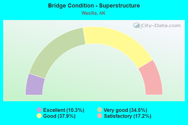
- Bridge Condition - Superstructure
- 10.3%Excellent
- 34.5%Very good
- 37.9%Good
- 17.2%Satisfactory
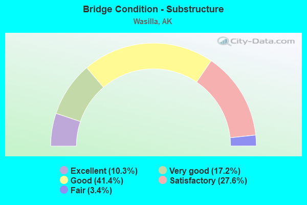
- Bridge Condition - Substructure
- 10.3%Excellent
- 17.2%Very good
- 41.4%Good
- 27.6%Satisfactory
- 3.4%Fair
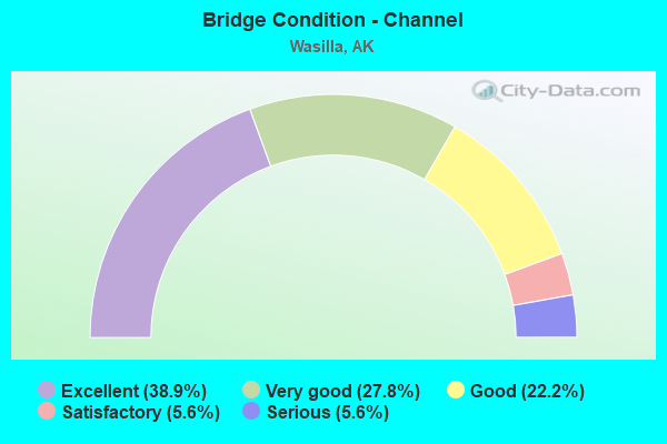
- Bridge Condition - Channel
- 38.9%Excellent
- 27.8%Very good
- 22.2%Good
- 5.6%Satisfactory
- 5.6%Serious
Find on map >> Show street view
Structure Number: 212, Location: MILE POINT 48.3 (Lat: 61.923933, Lng: -150.071469), Route carried "on" structure: Interstate A41, Year Built: 1962, Status: Open, Structure Length: 6.60m (21.65ft), Average Daily Traffic: 2,640 (year 2020), Truck Traffic: 17%, Average Future Daily Traffic: 3,080 (year 2039), Design Load: HS 20, Features Intersected: KASHWITNA RIVER, Facility Carried by Structure: PARKS HIGHWAY
Minimum Vertical Clearance: 5.42m (17.78ft), Kilometerpoint: 77.715, Lanes on structure: 2, Base Highway Network: Yes, Owner: State Highway Agency, Approaching Roadway Width: 9.8m (32.2ft), Material/Design: Prestressed concrete, Design/Construction: Stringer/Multi-beam, Number Of Spans In Main Unit: 3, Length of Maximum Span: 21.3m (69.9ft), Curb or Sidewalk Widths: Left: 0.5m (1.6ft), Right: 0.5m (1.6ft), Curb-To-Curb Width: 8.5m (27.9ft), Out-to-Out Width: 10.1m (33.1ft)
Condition: Deck: Good, Superstructure: Satisfactory, Substructure: Good, Channel: Very good, Operating Rating: 55.2 metric tons, Method Used To Determine Operating Rating: Load Factor (LF), Inventory Rating: 25.5 metric tons, Method Used To Determine Inventory Rating: Load Factor (LF), Structural Evaluation: Equal to present minimum criteria, Deck Geometry: Meets minimum limits, Waterway Adequacy: Equal to present desirable criteria, Approach Roadway Alignment: Equal to present desirable criteria, Designated Inspection Frequency: Every 24 months, Inspection Date: June 2020, Deck Structure Type: Concrete Cast-file-Place, Wearing Surface/Protective System: Wearing Surface: Bituminous
Find on map >> Show street view
Structure Number: 103, Location: MILE POINT 6.8 (Lat: 61.642311, Lng: -149.526767), Route carried "on" structure: Spur State highway NSP00, Year Built: 1993, Status: Open, Structure Length: 6.71m (22.01ft), Average Daily Traffic: 875 (year 2018), Truck Traffic: 7%, Average Future Daily Traffic: 1,100 (year 2035), Design Load: HS 20+Mod, Features Intersected: LITTLE SUSITNA RIVER, Facility Carried by Structure: SCHROCK RD SPUR
Minimum Vertical Clearance: 30+ m (98+ ft), Kilometerpoint: 10.924, Lanes on structure: 2, Owner: State Highway Agency, Approaching Roadway Width: 8.5m (27.9ft), Skew: 1 degrees, Material/Design: Prestressed concrete, Design/Construction: Tee Beam, Number Of Spans In Main Unit: 2, Length of Maximum Span: 32.9m (107.9ft), Curb-To-Curb Width: 8.6m (28.2ft), Out-to-Out Width: 9.4m (30.8ft)
Condition: Deck: Good, Superstructure: Good, Substructure: Satisfactory, Channel: Excellent, Operating Rating: 74.4 metric tons, Method Used To Determine Operating Rating: Load Factor (LF), Inventory Rating: 38.6 metric tons, Method Used To Determine Inventory Rating: Load Factor (LF), Structural Evaluation: Equal to present minimum criteria, Deck Geometry: Somewhat better than minimum adequacy, Waterway Adequacy: Superior to present desirable criteria, Approach Roadway Alignment: Equal to present desirable criteria, Designated Inspection Frequency: Every 24 months, Inspection Date: June 2020, Deck Structure Type: Other, Wearing Surface/Protective System: Wearing Surface: Bituminous, Deck Protection: Epoxy Coated Reinforcing
Find on map >> Show street view
Structure Number: 1124, Location: MILE POINT 30.4 (Lat: 61.503889, Lng: -149.249444), Route carried "on" structure: Interstate A16, Year Built: 1965, Year Reconstructed: 1993, Status: Open, Structure Length: 34.36m (112.73ft), Average Daily Traffic: 13,300 (year 2020), Truck Traffic: 8%, Average Future Daily Traffic: 15,400 (year 2039), Design Load: HS 25 or greater, Features Intersected: MATANUSKA RIV NORTHBOUND, Facility Carried by Structure: GLENN HIGHWAY
Minimum Vertical Clearance: 4.98m (16.34ft), Kilometerpoint: 48.911, Lanes on structure: 2, Base Highway Network: Yes, Owner: State Highway Agency, Approaching Roadway Width: 11.6m (38.1ft), Material/Design: Steel continuous, Design/Construction: Stringer/Multi-beam, Number Of Spans In Main Unit: 6, Length of Maximum Span: 61.6m (202.1ft), Curb-To-Curb Width: 11.6m (38.1ft), Out-to-Out Width: 12.2m (40.0ft)
Condition: Deck: Satisfactory, Superstructure: Satisfactory, Substructure: Satisfactory, Channel: Very good, Inventory Rating: 37.4 metric tons, Method Used To Determine Inventory Rating: Load Factor (LF), Structural Evaluation: Equal to present minimum criteria, Deck Geometry: Equal to present minimum criteria, Waterway Adequacy: Equal to present desirable criteria, Approach Roadway Alignment: Better than present minimum criteria, Designated Inspection Frequency: Every 24 months, Critical Feature Inspection Frequency: Every 24 months, Inspection Date: July 2021, Critical Feature Inspection Date: June 2020, Deck Structure Type: Concrete Cast-file-Place, Wearing Surface/Protective System: Wearing Surface: Bituminous, Membrane: Preformed Fabric, Deck Protection: Epoxy Coated Reinforcing
Find on map >> Show street view
Structure Number: 1698, Location: WASILLA (Lat: 61.655911, Lng: -149.463847), Route carried "on" structure: Spur County highway NSPCY, Year Built: 1984, Status: Open, Structure Length: 5.64m (18.50ft), Average Daily Traffic: 10 (year 2018), Truck Traffic: 1%, Average Future Daily Traffic: 12 (year 2035), Design Load: HS 20, Features Intersected: LITTLE SUSITNA RIVER, Facility Carried by Structure: N SUSHANA ST
Minimum Vertical Clearance: 30+ m (98+ ft), Kilometerpoint: 0.000, Lanes on structure: 2, Owner: County Highway Agency, Approaching Roadway Width: 9.1m (29.9ft), Skew: 1 degrees, Material/Design: Prestressed concrete, Design/Construction: Tee Beam, Number Of Spans In Main Unit: 2, Length of Maximum Span: 27.7m (90.9ft), Curb-To-Curb Width: 9.1m (29.9ft), Out-to-Out Width: 9.4m (30.8ft)
Condition: Deck: Satisfactory, Superstructure: Good, Substructure: Good, Channel: Excellent, Operating Rating: 86.2 metric tons, Method Used To Determine Operating Rating: Load Factor (LF), Inventory Rating: 30.4 metric tons, Method Used To Determine Inventory Rating: Load Factor (LF), Structural Evaluation: Better than present minimum criteria, Deck Geometry: Better than present minimum criteria, Waterway Adequacy: Equal to present desirable criteria, Approach Roadway Alignment: Better than present minimum criteria, Designated Inspection Frequency: Every 24 months, Inspection Date: June 2020, Deck Structure Type: Other, Wearing Surface/Protective System: Wearing Surface: Monolithic Concrete
Find on map >> Show street view
Structure Number: 1708, Location: WASILLA (Lat: 61.572278, Lng: -149.308894), Route carried "on" structure: County highway , Year Built: 2010, Status: Open, Structure Length: 1.59m (5.22ft), Average Daily Traffic: 50 (year 2018), Truck Traffic: 1%, Average Future Daily Traffic: 60 (year 2035), Design Load: Greater than HL93, Features Intersected: WASILLA CREEK, Facility Carried by Structure: GRANTHAM ROAD
Minimum Vertical Clearance: 30+ m (98+ ft), Kilometerpoint: 0.193, Lanes on structure: 2, Owner: County Highway Agency, Approaching Roadway Width: 8.5m (27.9ft), Material/Design: Steel, Design/Construction: Stringer/Multi-beam, Number Of Spans In Main Unit: 1, Length of Maximum Span: 15.0m (49.2ft), Curb-To-Curb Width: 8.5m (27.9ft), Out-to-Out Width: 8.5m (27.9ft)
Condition: Deck: Very good, Superstructure: Very good, Substructure: Very good, Channel: Good, Operating Rating: 98.8 metric tons, Method Used To Determine Operating Rating: Load Factor (LF), Inventory Rating: 46.0 metric tons, Method Used To Determine Inventory Rating: Load Factor (LF), Structural Evaluation: Equal to present desirable criteria, Deck Geometry: Better than present minimum criteria, Waterway Adequacy: Equal to present desirable criteria, Approach Roadway Alignment: Equal to present desirable criteria, Designated Inspection Frequency: Every 24 months, Inspection Date: June 2020, Deck Structure Type: Corrugated Steel, Wearing Surface/Protective System: Wearing Surface: Monolithic Concrete, Deck Protection: Galvanized Reinforcing
Find on map >> Show street view
Structure Number: 1709, Location: WASILLA (Lat: 61.651675, Lng: -149.430789), Route carried "on" structure: Spur County highway , Year Built: 2012, Status: Open, Structure Length: 1.89m (6.20ft), Average Daily Traffic: 30 (year 2018), Truck Traffic: 1%, Average Future Daily Traffic: 40 (year 2035), Design Load: HL 93, Features Intersected: LITTLE SUSITNA RIV TRIB, Facility Carried by Structure: N MOOSE MEADOWS RD
Minimum Vertical Clearance: 30+ m (98+ ft), Kilometerpoint: 0.000, Lanes on structure: 1, Owner: County Highway Agency, Approaching Roadway Width: 4.9m (16.1ft), Material/Design: Steel, Design/Construction: Stringer/Multi-beam, Number Of Spans In Main Unit: 1, Length of Maximum Span: 17.6m (57.7ft), Curb-To-Curb Width: 4.9m (16.1ft), Out-to-Out Width: 4.9m (16.1ft)
Condition: Deck: Excellent, Superstructure: Excellent, Substructure: Good, Channel: Good, Inventory Rating: 62.7 metric tons, Method Used To Determine Inventory Rating: Load Factor (LF), Structural Evaluation: Better than present minimum criteria, Deck Geometry: High priority of corrective action, Waterway Adequacy: Meets minimum limits, Approach Roadway Alignment: Meets minimum limits, Designated Inspection Frequency: Every 24 months, Inspection Date: June 2020, Deck Structure Type: Concrete Cast-file-Place, Wearing Surface/Protective System: Wearing Surface: Monolithic Concrete
Find on map >> Show street view
Structure Number: 1712, Location: WASILLA (Lat: 61.608033, Lng: -149.292469), Route carried "on" structure: Spur County highway , Year Built: 2013, Status: Open, Structure Length: 1.89m (6.20ft), Average Daily Traffic: 10 (year 2018), Truck Traffic: 1%, Average Future Daily Traffic: 15 (year 2035), Design Load: HL 93, Features Intersected: COTTONWOOD CREEK, Facility Carried by Structure: EARL DRIVE
Minimum Vertical Clearance: 30+ m (98+ ft), Kilometerpoint: 0.000, Lanes on structure: 1, Owner: County Highway Agency, Approaching Roadway Width: 4.9m (16.1ft), Material/Design: Steel, Design/Construction: Stringer/Multi-beam, Number Of Spans In Main Unit: 1, Length of Maximum Span: 18.0m (59.1ft), Curb-To-Curb Width: 4.9m (16.1ft), Out-to-Out Width: 4.9m (16.1ft)
Condition: Deck: Very good, Superstructure: Excellent, Substructure: Excellent, Channel: Excellent, Inventory Rating: 63.2 metric tons, Method Used To Determine Inventory Rating: Load Factor (LF), Structural Evaluation: Superior to present desirable criteria, Deck Geometry: High priority of corrective action, Waterway Adequacy: Superior to present desirable criteria, Approach Roadway Alignment: Equal to present minimum criteria, Designated Inspection Frequency: Every 24 months, Inspection Date: June 2020, Deck Structure Type: Concrete Cast-file-Place, Wearing Surface/Protective System: Wearing Surface: Monolithic Concrete
Find on map >> Show street view
Structure Number: 1887, Location: MILE POINT 29.6 (Lat: 61.494800, Lng: -149.244600), Route carried "on" structure: Interstate A1, Year Built: 1993, Status: Open, Structure Length: 7.62m (25.00ft), Average Daily Traffic: 13,300 (year 2020), Truck Traffic: 8%, Average Future Daily Traffic: 15,400 (year 2039), Design Load: HS 25 or greater, Features Intersected: KNIK RIV. OVERFLOW S.B., Facility Carried by Structure: GLENN HIGHWAY
Minimum Vertical Clearance: 4.98m (16.34ft), Kilometerpoint: 47.692, Lanes on structure: 2, Base Highway Network: Yes, Owner: State Highway Agency, Approaching Roadway Width: 12.8m (42.0ft), Material/Design: Prestressed concrete, Design/Construction: Tee Beam, Number Of Spans In Main Unit: 2, Length of Maximum Span: 37.5m (123.0ft), Curb-To-Curb Width: 11.6m (38.1ft), Out-to-Out Width: 12.3m (40.4ft)
Condition: Deck: Satisfactory, Superstructure: Good, Substructure: Satisfactory, Channel: Excellent, Operating Rating: 87.7 metric tons, Method Used To Determine Operating Rating: Load Factor (LF), Inventory Rating: 40.4 metric tons, Method Used To Determine Inventory Rating: Load Factor (LF), Structural Evaluation: Equal to present minimum criteria, Deck Geometry: Equal to present minimum criteria, Waterway Adequacy: Superior to present desirable criteria, Approach Roadway Alignment: Superior to present desirable criteria, Designated Inspection Frequency: Every 24 months, Underwater Inspection Frequency: Every 60 months, Inspection Date: July 2021, Underwater Inspection Date: June 2021, Deck Structure Type: Other, Wearing Surface/Protective System: Wearing Surface: Bituminous, Deck Protection: Epoxy Coated Reinforcing
Find on map >> Show street view
Structure Number: 1888, Location: MILE POINT 29.6 (Lat: 61.494722, Lng: -149.244167), Route carried "on" structure: Interstate A1, Year Built: 1993, Status: Open, Structure Length: 7.62m (25.00ft), Average Daily Traffic: 13,300 (year 2020), Truck Traffic: 8%, Average Future Daily Traffic: 15,400 (year 2039), Design Load: HS 25 or greater, Features Intersected: KNIK RIV. OVERFLOW N.B., Facility Carried by Structure: GLENN HIGHWAY
Minimum Vertical Clearance: 4.98m (16.34ft), Kilometerpoint: 47.692, Lanes on structure: 2, Base Highway Network: Yes, Owner: State Highway Agency, Approaching Roadway Width: 13.4m (44.0ft), Material/Design: Prestressed concrete, Design/Construction: Tee Beam, Number Of Spans In Main Unit: 2, Length of Maximum Span: 37.5m (123.0ft), Curb-To-Curb Width: 11.6m (38.1ft), Out-to-Out Width: 13.0m (42.7ft)
Condition: Deck: Satisfactory, Superstructure: Good, Substructure: Satisfactory, Channel: Excellent, Operating Rating: 85.6 metric tons, Method Used To Determine Operating Rating: Load Factor (LF), Inventory Rating: 45.9 metric tons, Method Used To Determine Inventory Rating: Load Factor (LF), Structural Evaluation: Equal to present minimum criteria, Deck Geometry: Equal to present minimum criteria, Waterway Adequacy: Superior to present desirable criteria, Approach Roadway Alignment: Superior to present desirable criteria, Designated Inspection Frequency: Every 24 months, Underwater Inspection Frequency: Every 60 months, Inspection Date: July 2021, Underwater Inspection Date: June 2021, Deck Structure Type: Other, Wearing Surface/Protective System: Wearing Surface: Bituminous, Deck Protection: Epoxy Coated Reinforcing
Find on map >> Show street view
Structure Number: 1889, Location: MILE POINT 30.5 (Lat: 61.503800, Lng: -149.249900), Route carried "on" structure: Interstate A1, Year Built: 1993, Status: Open, Structure Length: 34.36m (112.73ft), Average Daily Traffic: 13,300 (year 2020), Truck Traffic: 8%, Average Future Daily Traffic: 15,400 (year 2039), Design Load: HS 25 or greater, Features Intersected: MATANUSKA RIV SOUTHBOUND, Facility Carried by Structure: GLENN HIGHWAY
Minimum Vertical Clearance: 4.98m (16.34ft), Kilometerpoint: 49.018, Lanes on structure: 2, Base Highway Network: Yes, Owner: State Highway Agency, Approaching Roadway Width: 11.6m (38.1ft), Material/Design: Steel continuous, Design/Construction: Stringer/Multi-beam, Number Of Spans In Main Unit: 6, Length of Maximum Span: 61.6m (202.1ft), Curb or Sidewalk Widths: Left: 0.0m, Right: 1.2m (3.9ft), Curb-To-Curb Width: 11.6m (38.1ft), Out-to-Out Width: 12.2m (40.0ft)
Condition: Deck: Satisfactory, Superstructure: Satisfactory, Substructure: Satisfactory, Channel: Very good, Inventory Rating: 35.3 metric tons, Method Used To Determine Inventory Rating: Load Factor (LF), Structural Evaluation: Equal to present minimum criteria, Deck Geometry: Equal to present minimum criteria, Waterway Adequacy: Superior to present desirable criteria, Approach Roadway Alignment: Superior to present desirable criteria, Designated Inspection Frequency: Every 24 months, Inspection Date: July 2021, Deck Structure Type: Concrete Cast-file-Place, Wearing Surface/Protective System: Wearing Surface: Bituminous, Deck Protection: Epoxy Coated Reinforcing
Find on map >> Show street view
Structure Number: 1897, Location: MILE POINT 10.2 (Lat: 61.575119, Lng: -149.412969), Route carried "on" structure: State highway , Year Built: 2002, Status: Open, Structure Length: 2.80m (9.19ft), Average Daily Traffic: 14,000 (year 2020), Truck Traffic: 5%, Average Future Daily Traffic: 16,300 (year 2039), Design Load: HS 25 or greater, Features Intersected: COTTONWOOD OVERHEAD, Facility Carried by Structure: PALMER-WASILL EXT
Minimum Vertical Clearance: 30+ m (98+ ft), Kilometerpoint: 16.470, Lanes on structure: 3, Base Highway Network: Yes, Owner: State Highway Agency, Approaching Roadway Width: 29.0m (95.1ft), Skew: 25 degrees, Material/Design: Prestressed concrete, Design/Construction: Tee Beam, Number Of Spans In Main Unit: 1, Length of Maximum Span: 26.6m (87.3ft), Curb or Sidewalk Widths: Left: 0.0m, Right: 3.4m (11.2ft), Curb-To-Curb Width: 20.9m (68.6ft), Out-to-Out Width: 29.0m (95.1ft)
Condition: Deck: Good, Superstructure: Good, Substructure: Fair, Operating Rating: 85.5 metric tons, Method Used To Determine Operating Rating: Load Factor (LF), Inventory Rating: 30.4 metric tons, Method Used To Determine Inventory Rating: Load Factor (LF), Structural Evaluation: Somewhat better than minimum adequacy, Deck Geometry: Superior to present desirable criteria, Underclear: Superior to present desirable criteria, Approach Roadway Alignment: Better than present minimum criteria, Designated Inspection Frequency: Every 24 months, Inspection Date: June 2020, Deck Structure Type: Other, Wearing Surface/Protective System: Wearing Surface: Bituminous, Membrane: Preformed Fabric, Deck Protection: Epoxy Coated Reinforcing
Find on map >> Show street view
Structure Number: 1903, Location: MILE POINT 1.2 (Lat: 61.562744, Lng: -149.266203), Route carried "on" structure: Ramp State highway , Year Built: 2000, Status: Open, Structure Length: 8.88m (29.13ft), Average Daily Traffic: 6,780 (year 2020), Truck Traffic: 8%, Average Future Daily Traffic: 9,760 (year 2039), Design Load: HS 20+Mod, Features Intersected: TRUNK ROAD O.C., Facility Carried by Structure: TRUNK ROAD
Minimum Vertical Clearance: 30+ m (98+ ft), Kilometerpoint: 1.931, Lanes on structure: 3, Lanes under structure: 4, Owner: State Highway Agency, Approaching Roadway Width: 18.3m (60.0ft), Skew: 22 degrees, Material/Design: Prestressed concrete, Design/Construction: Tee Beam, Number Of Spans In Main Unit: 2, Length of Maximum Span: 43.6m (143.0ft), Curb or Sidewalk Widths: Left: 0.0m, Right: 3.9m (12.8ft), Curb-To-Curb Width: 16.3m (53.5ft), Out-to-Out Width: 22.5m (73.8ft)
Condition: Deck: Very good, Superstructure: Good, Substructure: Good, Inventory Rating: 54.0 metric tons, Method Used To Determine Inventory Rating: Load Factor (LF), Structural Evaluation: Better than present minimum criteria, Deck Geometry: Superior to present desirable criteria, Underclear: Equal to present minimum criteria, Approach Roadway Alignment: Equal to present desirable criteria, Designated Inspection Frequency: Every 24 months, Inspection Date: June 2020, Deck Structure Type: Other, Wearing Surface/Protective System: Wearing Surface: Bituminous, Membrane: Preformed Fabric, Deck Protection: Epoxy Coated Reinforcing
Find on map >> Show street view
Structure Number: 1922, Location: MILE POINT 11.5 (Lat: 61.580644, Lng: -149.571214), Route carried "on" structure: Interstate A40, Year Built: 1995, Status: Open, Structure Length: 4.50m (14.76ft), Average Daily Traffic: 9,700 (year 2020), Truck Traffic: 6%, Average Future Daily Traffic: 11,300 (year 2039), Design Load: HS 25 or greater, Features Intersected: WASILLA OVERHEAD SB, Facility Carried by Structure: PARKS HIGHWAY
Minimum Vertical Clearance: 5.42m (17.78ft), Kilometerpoint: 18.459, Lanes on structure: 2, Base Highway Network: Yes, Owner: State Highway Agency, Approaching Roadway Width: 12.2m (40.0ft), Skew: 3 degrees, Material/Design: Prestressed concrete, Design/Construction: Tee Beam, Number Of Spans In Main Unit: 1, Length of Maximum Span: 34.7m (113.8ft), Curb-To-Curb Width: 12.2m (40.0ft), Out-to-Out Width: 13.1m (43.0ft)
Condition: Deck: Good, Superstructure: Very good, Substructure: Good, Operating Rating: 80.1 metric tons, Method Used To Determine Operating Rating: Load Factor (LF), Inventory Rating: 36.9 metric tons, Method Used To Determine Inventory Rating: Load Factor (LF), Structural Evaluation: Better than present minimum criteria, Deck Geometry: Better than present minimum criteria, Underclear: Superior to present desirable criteria, Approach Roadway Alignment: Equal to present desirable criteria, Designated Inspection Frequency: Every 24 months, Inspection Date: June 2020, Deck Structure Type: Other, Wearing Surface/Protective System: Wearing Surface: Bituminous, Membrane: Preformed Fabric, Deck Protection: Epoxy Coated Reinforcing
Find on map >> Show street view
Structure Number: 1989, Location: MILE POINT 4.2 (Lat: 61.571172, Lng: -149.359767), Route carried "on" structure: Interstate , Year Built: 2005, Status: Open, Structure Length: 5.89m (19.32ft), Average Daily Traffic: 32,100 (year 2020), Truck Traffic: 6%, Average Future Daily Traffic: 48,300 (year 2039), Design Load: HL 93, Features Intersected: SEWARD MERIDIAN U.C., Facility Carried by Structure: PARKS HIGHWAY
Minimum Vertical Clearance: 5.42m (17.78ft), Kilometerpoint: 6.695, Lanes on structure: 4, Lanes under structure: 5, Base Highway Network: Yes, Owner: State Highway Agency, Approaching Roadway Width: 25.8m (84.6ft), Skew: 31 degrees, Material/Design: Prestressed concrete, Design/Construction: Box Beam or Girders - Multiple, Number Of Spans In Main Unit: 1, Length of Maximum Span: 57.2m (187.7ft), Curb-To-Curb Width: 24.6m (80.7ft), Out-to-Out Width: 26.0m (85.3ft)
Condition: Deck: Very good, Superstructure: Very good, Substructure: Very good, Operating Rating: 81.6 metric tons, Method Used To Determine Operating Rating: Load Factor (LF), Inventory Rating: 37.6 metric tons, Method Used To Determine Inventory Rating: Load Factor (LF), Structural Evaluation: Equal to present desirable criteria, Deck Geometry: Superior to present desirable criteria, Underclear: Superior to present desirable criteria, Approach Roadway Alignment: Better than present minimum criteria, Designated Inspection Frequency: Every 24 months, Inspection Date: June 2020, Deck Structure Type: Other, Wearing Surface/Protective System: Wearing Surface: Bituminous, Membrane: Preformed Fabric, Deck Protection: Epoxy Coated Reinforcing
Find on map >> Show street view
Structure Number: 2031, Location: MILE POINT 2.6 (Lat: 61.567806, Lng: -149.313881), Route carried "on" structure: State highway , Year Built: 2002, Status: Open, Structure Length: 2.60m (8.53ft), Average Daily Traffic: 13,200 (year 2020), Truck Traffic: 5%, Average Future Daily Traffic: 15,300 (year 2039), Design Load: HS 25 or greater, Features Intersected: WASILLA CR SOUTHBOUND, Facility Carried by Structure: PARKS HIGHWAY
Minimum Vertical Clearance: 5.42m (17.78ft), Kilometerpoint: 4.184, Lanes on structure: 2, Base Highway Network: Yes, Owner: State Highway Agency, Approaching Roadway Width: 11.6m (38.1ft), Skew: 1 degrees, Material/Design: Prestressed concrete, Design/Construction: Tee Beam, Number Of Spans In Main Unit: 1, Length of Maximum Span: 24.5m (80.4ft), Curb-To-Curb Width: 11.4m (37.4ft), Out-to-Out Width: 12.3m (40.4ft)
Condition: Deck: Very good, Superstructure: Good, Substructure: Good, Channel: Very good, Inventory Rating: 48.6 metric tons, Method Used To Determine Inventory Rating: Load Factor (LF), Structural Evaluation: Better than present minimum criteria, Deck Geometry: Somewhat better than minimum adequacy, Waterway Adequacy: Better than present minimum criteria, Approach Roadway Alignment: Better than present minimum criteria, Designated Inspection Frequency: Every 24 months, Inspection Date: June 2020, Deck Structure Type: Other, Wearing Surface/Protective System: Wearing Surface: Bituminous, Membrane: Preformed Fabric, Deck Protection: Epoxy Coated Reinforcing
Find on map >> Show street view
Structure Number: 2032, Location: MILE POINT 2.6 (Lat: 61.568042, Lng: -149.313742), Route carried "on" structure: State highway , Year Built: 2002, Status: Open, Structure Length: 2.60m (8.53ft), Average Daily Traffic: 13,200 (year 2020), Truck Traffic: 5%, Average Future Daily Traffic: 15,300 (year 2039), Design Load: HS 25 or greater, Features Intersected: WASILLA CR NORTHBOUND, Facility Carried by Structure: PARKS HIGHWAY
Minimum Vertical Clearance: 5.42m (17.78ft), Kilometerpoint: 4.184, Lanes on structure: 2, Base Highway Network: Yes, Owner: State Highway Agency, Approaching Roadway Width: 11.6m (38.1ft), Skew: 1 degrees, Material/Design: Prestressed concrete, Design/Construction: Tee Beam, Number Of Spans In Main Unit: 1, Length of Maximum Span: 24.5m (80.4ft), Curb-To-Curb Width: 11.4m (37.4ft), Out-to-Out Width: 12.3m (40.4ft)
Condition: Deck: Very good, Superstructure: Good, Substructure: Good, Channel: Very good, Inventory Rating: 48.6 metric tons, Method Used To Determine Inventory Rating: Load Factor (LF), Structural Evaluation: Better than present minimum criteria, Deck Geometry: Somewhat better than minimum adequacy, Waterway Adequacy: Better than present minimum criteria, Approach Roadway Alignment: Better than present minimum criteria, Designated Inspection Frequency: Every 24 months, Inspection Date: June 2020, Deck Structure Type: Other, Wearing Surface/Protective System: Wearing Surface: Bituminous, Membrane: Preformed Fabric, Deck Protection: Epoxy Coated Reinforcing
Find on map >> Show street view
Structure Number: 2033, Location: MILE POINT 2.6 (Lat: 61.567614, Lng: -149.313344), Route carried "on" structure: State highway , Year Built: 2002, Status: Open, Structure Length: 2.60m (8.53ft), Average Daily Traffic: 13,200 (year 2020), Truck Traffic: 5%, Average Future Daily Traffic: 15,300 (year 2039), Design Load: HS 25 or greater, Features Intersected: HYER RD UC SOUTHBOUND, Facility Carried by Structure: PARKS HIGHWAY
Minimum Vertical Clearance: 5.42m (17.78ft), Kilometerpoint: 4.184, Lanes on structure: 2, Lanes under structure: 2, Base Highway Network: Yes, Owner: State Highway Agency, Approaching Roadway Width: 11.6m (38.1ft), Skew: 1 degrees, Material/Design: Prestressed concrete, Design/Construction: Tee Beam, Number Of Spans In Main Unit: 1, Length of Maximum Span: 24.5m (80.4ft), Curb-To-Curb Width: 11.4m (37.4ft), Out-to-Out Width: 12.3m (40.4ft)
Condition: Deck: Good, Superstructure: Very good, Substructure: Good, Inventory Rating: 48.6 metric tons, Method Used To Determine Inventory Rating: Load Factor (LF), Structural Evaluation: Better than present minimum criteria, Deck Geometry: Somewhat better than minimum adequacy, Underclear: Superior to present desirable criteria, Approach Roadway Alignment: Better than present minimum criteria, Designated Inspection Frequency: Every 24 months, Inspection Date: June 2020, Deck Structure Type: Other, Wearing Surface/Protective System: Wearing Surface: Bituminous, Membrane: Preformed Fabric, Deck Protection: Epoxy Coated Reinforcing
Find on map >> Show street view
Structure Number: 2037, Location: MILE POINT 2.0 (Lat: 61.569675, Lng: -149.313622), Route carried "on" structure: ServiceState highway , Year Built: 2002, Status: Open, Structure Length: 2.35m (7.71ft), Average Daily Traffic: 1,480 (year 2020), Truck Traffic: 5%, Average Future Daily Traffic: 1,930 (year 2039), Design Load: HS 25 or greater, Features Intersected: WASILLA CR N FRONTAGE #2, Facility Carried by Structure: EAST BLUE LUPINE
Minimum Vertical Clearance: 30+ m (98+ ft), Kilometerpoint: 3.217, Lanes on structure: 2, Owner: State Highway Agency, Approaching Roadway Width: 10.2m (33.5ft), Material/Design: Prestressed concrete, Design/Construction: Tee Beam, Number Of Spans In Main Unit: 1, Length of Maximum Span: 22.0m (72.2ft), Curb-To-Curb Width: 10.2m (33.5ft), Out-to-Out Width: 14.7m (48.2ft)
Condition: Deck: Very good, Superstructure: Very good, Substructure: Very good, Channel: Good, Inventory Rating: 54.5 metric tons, Method Used To Determine Inventory Rating: Load Factor (LF), Structural Evaluation: Equal to present desirable criteria, Deck Geometry: Somewhat better than minimum adequacy, Waterway Adequacy: Better than present minimum criteria, Approach Roadway Alignment: Better than present minimum criteria, Designated Inspection Frequency: Every 24 months, Inspection Date: June 2020, Deck Structure Type: Other, Wearing Surface/Protective System: Wearing Surface: Bituminous, Membrane: Preformed Fabric, Deck Protection: Epoxy Coated Reinforcing
Find on map >> Show street view
Structure Number: 2116, Location: MILE POINT 0.9 (Lat: 61.552411, Lng: -149.247189), Route carried "on" structure: Interstate , Year Built: 2004, Status: Open, Structure Length: 24.99m (81.99ft), Average Daily Traffic: 3,272 (year 2018), Truck Traffic: 8%, Average Future Daily Traffic: 27,000 (year 2035), Design Load: HS 25 or greater, Features Intersected: SPRING CREEK NB, Facility Carried by Structure: PARKS HIGHWAY
Minimum Vertical Clearance: 5.42m (17.78ft), Kilometerpoint: 1.493, Lanes on structure: 2, Lanes under structure: 4, Base Highway Network: Yes, Owner: State Highway Agency, Approaching Roadway Width: 12.2m (40.0ft), Skew: 2 degrees, Material/Design: Prestressed concrete, Design/Construction: Tee Beam, Number Of Spans In Main Unit: 5, Length of Maximum Span: 50.3m (165.0ft), Curb-To-Curb Width: 11.4m (37.4ft), Out-to-Out Width: 12.3m (40.4ft)
Condition: Deck: Very good, Superstructure: Satisfactory, Substructure: Good, Channel: Excellent, Operating Rating: 86.3 metric tons, Method Used To Determine Operating Rating: Load Factor (LF), Inventory Rating: 39.3 metric tons, Method Used To Determine Inventory Rating: Load Factor (LF), Structural Evaluation: Equal to present minimum criteria, Deck Geometry: Somewhat better than minimum adequacy, Underclear: Equal to present minimum criteria, Waterway Adequacy: Superior to present desirable criteria, Approach Roadway Alignment: Equal to present minimum criteria, Designated Inspection Frequency: Every 24 months, Inspection Date: June 2020, Deck Structure Type: Concrete Cast-file-Place, Wearing Surface/Protective System: Wearing Surface: Bituminous, Membrane: Epoxy, Deck Protection: Epoxy Coated Reinforcing
Find on map >> Show street view
Structure Number: 2117, Location: MILE POINT 0.3 (Lat: 61.549056, Lng: -149.249172), Route carried "on" structure: Interstate , Year Built: 2004, Status: Open, Structure Length: 2.77m (9.09ft), Average Daily Traffic: 2,857 (year 2018), Truck Traffic: 8%, Average Future Daily Traffic: 27,000 (year 2035), Design Load: HS 25 or greater, Features Intersected: GLENN PARKS OVERHEAD SB, Facility Carried by Structure: PARKS HIGHWAY
Minimum Vertical Clearance: 5.42m (17.78ft), Kilometerpoint: 0.517, Lanes on structure: 2, Base Highway Network: Yes, Owner: State Highway Agency, Approaching Roadway Width: 12.2m (40.0ft), Material/Design: Prestressed concrete, Design/Construction: Box Beam or Girders - Multiple, Number Of Spans In Main Unit: 1, Length of Maximum Span: 26.8m (87.9ft), Curb-To-Curb Width: 11.4m (37.4ft), Out-to-Out Width: 12.3m (40.4ft)
Condition: Deck: Very good, Superstructure: Good, Substructure: Satisfactory, Operating Rating: 72.6 metric tons, Method Used To Determine Operating Rating: Load Factor (LF), Inventory Rating: 43.5 metric tons, Method Used To Determine Inventory Rating: Load Factor (LF), Structural Evaluation: Equal to present minimum criteria, Deck Geometry: Somewhat better than minimum adequacy, Underclear: Superior to present desirable criteria, Approach Roadway Alignment: Equal to present minimum criteria, Designated Inspection Frequency: Every 24 months, Inspection Date: June 2020, Deck Structure Type: Other, Wearing Surface/Protective System: Wearing Surface: Bituminous, Membrane: Epoxy, Deck Protection: Epoxy Coated Reinforcing
Find on map >> Show street view
Structure Number: 2118, Location: MILE POINT 0.7 (Lat: 61.548978, Lng: -149.248639), Route carried "on" structure: Interstate , Year Built: 2004, Status: Open, Structure Length: 2.77m (9.09ft), Average Daily Traffic: 3,272 (year 2018), Truck Traffic: 8%, Average Future Daily Traffic: 27,000 (year 2035), Design Load: HS 25 or greater, Features Intersected: GLENN PARKS OVERHEAD NB, Facility Carried by Structure: PARKS HIGHWAY
Minimum Vertical Clearance: 5.42m (17.78ft), Kilometerpoint: 1.101, Lanes on structure: 2, Base Highway Network: Yes, Owner: State Highway Agency, Approaching Roadway Width: 12.2m (40.0ft), Material/Design: Prestressed concrete, Design/Construction: Box Beam or Girders - Multiple, Number Of Spans In Main Unit: 1, Length of Maximum Span: 26.8m (87.9ft), Curb-To-Curb Width: 11.4m (37.4ft), Out-to-Out Width: 12.3m (40.4ft)
Condition: Deck: Very good, Superstructure: Good, Substructure: Satisfactory, Operating Rating: 72.6 metric tons, Method Used To Determine Operating Rating: Load Factor (LF), Inventory Rating: 43.5 metric tons, Method Used To Determine Inventory Rating: Load Factor (LF), Structural Evaluation: Equal to present minimum criteria, Deck Geometry: Somewhat better than minimum adequacy, Underclear: Superior to present desirable criteria, Approach Roadway Alignment: Equal to present minimum criteria, Designated Inspection Frequency: Every 24 months, Inspection Date: June 2020, Deck Structure Type: Other, Wearing Surface/Protective System: Wearing Surface: Bituminous, Membrane: Preformed Fabric, Deck Protection: Epoxy Coated Reinforcing
Find on map >> Show street view
Structure Number: 2119, Location: MILE POINT 33.7 (Lat: 61.549300, Lng: -149.251000), Route carried "on" structure: Ramp Interstate A1, Year Built: 2004, Status: Open, Structure Length: 2.83m (9.28ft), Average Daily Traffic: 1,245 (year 2020), Truck Traffic: 9%, Average Future Daily Traffic: 1,450 (year 2039), Design Load: HS 25 or greater, Features Intersected: PALMER-ANCHORAGE RAMP OH, Facility Carried by Structure: GLENN HIGHWAY
Minimum Vertical Clearance: 4.98m (16.34ft), Kilometerpoint: 54.235, Lanes on structure: 2, Base Highway Network: Yes, Owner: State Highway Agency, Approaching Roadway Width: 11.6m (38.1ft), Skew: 1 degrees, Material/Design: Prestressed concrete, Design/Construction: Box Beam or Girders - Multiple, Number Of Spans In Main Unit: 1, Length of Maximum Span: 27.4m (89.9ft), Curb-To-Curb Width: 10.8m (35.4ft), Out-to-Out Width: 11.7m (38.4ft)
Condition: Deck: Very good, Superstructure: Good, Substructure: Good, Operating Rating: 72.6 metric tons, Method Used To Determine Operating Rating: Load Factor (LF), Inventory Rating: 43.5 metric tons, Method Used To Determine Inventory Rating: Load Factor (LF), Structural Evaluation: Better than present minimum criteria, Deck Geometry: Better than present minimum criteria, Underclear: Superior to present desirable criteria, Approach Roadway Alignment: Equal to present minimum criteria, Designated Inspection Frequency: Every 24 months, Inspection Date: July 2021, Deck Structure Type: Other, Wearing Surface/Protective System: Wearing Surface: Bituminous, Membrane: Preformed Fabric, Deck Protection: Epoxy Coated Reinforcing
Find on map >> Show street view
Structure Number: 212, Location: MILE POINT 33.7 (Lat: 61.549300, Lng: -149.250800), Route carried "on" structure: Ramp Interstate A1, Year Built: 2004, Status: Open, Structure Length: 2.83m (9.28ft), Average Daily Traffic: 1,245 (year 2020), Truck Traffic: 9%, Average Future Daily Traffic: 1,450 (year 2039), Design Load: HS 25 or greater, Features Intersected: ANCHORAGE-PALMER RAMP OH, Facility Carried by Structure: GLENN HIGHWAY
Minimum Vertical Clearance: 4.98m (16.34ft), Kilometerpoint: 54.235, Lanes on structure: 2, Base Highway Network: Yes, Owner: State Highway Agency, Approaching Roadway Width: 11.6m (38.1ft), Skew: 1 degrees, Material/Design: Prestressed concrete, Design/Construction: Box Beam or Girders - Multiple, Number Of Spans In Main Unit: 1, Length of Maximum Span: 27.4m (89.9ft), Curb-To-Curb Width: 10.8m (35.4ft), Out-to-Out Width: 11.7m (38.4ft)
Condition: Deck: Very good, Superstructure: Satisfactory, Substructure: Satisfactory, Operating Rating: 72.6 metric tons, Method Used To Determine Operating Rating: Load Factor (LF), Inventory Rating: 43.5 metric tons, Method Used To Determine Inventory Rating: Load Factor (LF), Structural Evaluation: Equal to present minimum criteria, Deck Geometry: Better than present minimum criteria, Underclear: Superior to present desirable criteria, Approach Roadway Alignment: Equal to present minimum criteria, Designated Inspection Frequency: Every 24 months, Inspection Date: July 2021, Deck Structure Type: Other, Wearing Surface/Protective System: Wearing Surface: Bituminous, Membrane: Preformed Fabric, Deck Protection: Epoxy Coated Reinforcing
Find on map >> Show street view
Structure Number: 2138, Location: MILE POINT 1.5 (Lat: 61.649906, Lng: -149.512614), Route carried "on" structure: Spur County highway NSP00, Year Built: 2004, Status: Open, Structure Length: 1.43m (4.69ft), Average Daily Traffic: 10 (year 2018), Truck Traffic: 1%, Average Future Daily Traffic: 13 (year 2035), Design Load: HS 20, Features Intersected: SWIFTWATER CREEK, Facility Carried by Structure: SWIFTWATER ROAD
Minimum Vertical Clearance: 30+ m (98+ ft), Kilometerpoint: 2.414, Lanes on structure: 2, Owner: County Highway Agency, Approaching Roadway Width: 8.5m (27.9ft), Material/Design: Steel, Design/Construction: Stringer/Multi-beam, Number Of Spans In Main Unit: 1, Length of Maximum Span: 14.1m (46.3ft), Curb-To-Curb Width: 8.5m (27.9ft), Out-to-Out Width: 8.5m (27.9ft)
Condition: Deck: Excellent, Superstructure: Very good, Substructure: Good, Channel: Good, Operating Rating: 54.5 metric tons, Method Used To Determine Operating Rating: Load Factor (LF), Inventory Rating: 32.7 metric tons, Method Used To Determine Inventory Rating: Load Factor (LF), Structural Evaluation: Better than present minimum criteria, Deck Geometry: Better than present minimum criteria, Waterway Adequacy: Better than present minimum criteria, Approach Roadway Alignment: Equal to present desirable criteria, Designated Inspection Frequency: Every 24 months, Inspection Date: June 2020, Deck Structure Type: Steel plate, Wearing Surface/Protective System: Wearing Surface: Bituminous
Find on map >> Show street view
Structure Number: 2225, Location: MILE POINT 0.1 (Lat: 61.665592, Lng: -149.339486), Route carried "on" structure: Spur County highway , Year Built: 2016, Status: Open, Structure Length: 2.67m (8.76ft), Average Daily Traffic: 10 (year 2018), Truck Traffic: 1%, Average Future Daily Traffic: 12 (year 2035), Design Load: HL 93, Features Intersected: LITTLE SUSITNA RIV TRIB, Facility Carried by Structure: E SHORTY STREET
Minimum Vertical Clearance: 30+ m (98+ ft), Kilometerpoint: 0.161, Lanes on structure: 1, Owner: City or Municipal Highway Agency, Approaching Roadway Width: 6.1m (20.0ft), Material/Design: Prestressed concrete, Design/Construction: Tee Beam, Number Of Spans In Main Unit: 1, Length of Maximum Span: 23.2m (76.1ft), Curb-To-Curb Width: 4.9m (16.1ft), Out-to-Out Width: 5.8m (19.0ft)
Condition: Deck: Excellent, Superstructure: Excellent, Substructure: Excellent, Channel: Excellent, Operating Rating: 87.7 metric tons, Method Used To Determine Operating Rating: Load Factor (LF), Inventory Rating: 40.4 metric tons, Method Used To Determine Inventory Rating: Load Factor (LF), Structural Evaluation: Superior to present desirable criteria, Deck Geometry: High priority of corrective action, Waterway Adequacy: Superior to present desirable criteria, Approach Roadway Alignment: Equal to present minimum criteria, Designated Inspection Frequency: Every 24 months, Inspection Date: June 2020, Deck Structure Type: Other, Wearing Surface/Protective System: Wearing Surface: Monolithic Concrete, Deck Protection: Epoxy Coated Reinforcing
Find on map >> Show street view
Structure Number: 2227, Location: MILE POINT 0.7 (Lat: 61.550617, Lng: -149.294019), Route carried "on" structure: Alternate County highway , Year Built: 2006, Status: Open, Structure Length: 1.28m (4.20ft), Average Daily Traffic: 850 (year 2020), Truck Traffic: 2%, Average Future Daily Traffic: 1,060 (year 2039), Design Load: HS 20, Features Intersected: WASILLA CREEK, Facility Carried by Structure: E NELSON ROAD
Minimum Vertical Clearance: 30+ m (98+ ft), Kilometerpoint: 1.127, Lanes on structure: 2, Owner: County Highway Agency, Approaching Roadway Width: 8.5m (27.9ft), Material/Design: Steel, Design/Construction: Stringer/Multi-beam, Number Of Spans In Main Unit: 1, Length of Maximum Span: 12.5m (41.0ft), Curb-To-Curb Width: 7.3m (24.0ft), Out-to-Out Width: 7.9m (25.9ft)
Condition: Deck: Very good, Superstructure: Very good, Substructure: Good, Channel: Serious, Operating Rating: 73.6 metric tons, Method Used To Determine Operating Rating: Load Factor (LF), Inventory Rating: 26.7 metric tons, Method Used To Determine Inventory Rating: Load Factor (LF), Structural Evaluation: Equal to present minimum criteria, Deck Geometry: Meets minimum limits, Waterway Adequacy: Better than present minimum criteria, Approach Roadway Alignment: Equal to present desirable criteria, Designated Inspection Frequency: Every 24 months, Inspection Date: June 2020, Deck Structure Type: Concrete Cast-file-Place, Wearing Surface/Protective System: Wearing Surface: Monolithic Concrete, Deck Protection: Galvanized Reinforcing
Find on map >> Show street view
Structure Number: 2238, Location: MILE POINT 0.1 (Lat: 61.552406, Lng: -149.316339), Route carried "on" structure: Alternate County highway , Year Built: 2006, Status: Open, Structure Length: 1.25m (4.10ft), Average Daily Traffic: 100 (year 2018), Truck Traffic: 1%, Average Future Daily Traffic: 110 (year 2035), Design Load: HS 20, Features Intersected: WASILLA CREEK, Facility Carried by Structure: FETLOCK DRIVE
Minimum Vertical Clearance: 30+ m (98+ ft), Kilometerpoint: 0.161, Lanes on structure: 2, Owner: County Highway Agency, Approaching Roadway Width: 7.3m (24.0ft), Material/Design: Steel, Design/Construction: Stringer/Multi-beam, Number Of Spans In Main Unit: 1, Length of Maximum Span: 12.5m (41.0ft), Curb or Sidewalk Widths: Left: 0.3m (1.0ft), Right: 0.3m (1.0ft), Curb-To-Curb Width: 7.3m (24.0ft), Out-to-Out Width: 7.9m (25.9ft)
Condition: Deck: Very good, Superstructure: Very good, Substructure: Very good, Channel: Satisfactory, Operating Rating: 68.9 metric tons, Method Used To Determine Operating Rating: Load Factor (LF), Inventory Rating: 24.9 metric tons, Method Used To Determine Inventory Rating: Load Factor (LF), Structural Evaluation: Equal to present minimum criteria, Deck Geometry: Equal to present minimum criteria, Waterway Adequacy: Better than present minimum criteria, Approach Roadway Alignment: Equal to present desirable criteria, Designated Inspection Frequency: Every 24 months, Inspection Date: June 2020, Deck Structure Type: Concrete Cast-file-Place, Wearing Surface/Protective System: Wearing Surface: Bituminous, Deck Protection: Galvanized Reinforcing
Find on map >> Show street view
Structure Number: 2291, Location: MILE POINT 11.5 (Lat: 61.580681, Lng: -149.571947), Route carried "on" structure: Interstate A40, Year Built: 2017, Status: Open, Structure Length: 6.86m (22.51ft), Average Daily Traffic: 9,700 (year 2020), Truck Traffic: 5%, Average Future Daily Traffic: 11,300 (year 2039), Design Load: HL 93, Features Intersected: WASILLA OVERHEAD NB, Facility Carried by Structure: PARKS HIGHWAY
Minimum Vertical Clearance: 5.42m (17.78ft), Kilometerpoint: 18.459, Lanes on structure: 2, Base Highway Network: Yes, Owner: State Highway Agency, Approaching Roadway Width: 12.2m (40.0ft), Skew: 3 degrees, Material/Design: Steel, Design/Construction: Stringer/Multi-beam, Number Of Spans In Main Unit: 1, Length of Maximum Span: 67.1m (220.1ft), Curb-To-Curb Width: 11.0m (36.1ft), Out-to-Out Width: 11.7m (38.4ft)
Condition: Deck: Excellent, Superstructure: Very good, Substructure: Excellent, Inventory Rating: 53.9 metric tons, Method Used To Determine Inventory Rating: Load Factor (LF), Structural Evaluation: Equal to present desirable criteria, Deck Geometry: Somewhat better than minimum adequacy, Underclear: Superior to present desirable criteria, Approach Roadway Alignment: Equal to present desirable criteria, Designated Inspection Frequency: Every 24 months, Inspection Date: June 2020, Deck Structure Type: Concrete Cast-file-Place, Wearing Surface/Protective System: Wearing Surface: Bituminous, Membrane: Preformed Fabric, Deck Protection: Epoxy Coated Reinforcing
Find on map >> Show street view
Structure Number: 2307, Location: MILE POINT 0.2 (Lat: 61.551578, Lng: -149.281500), Route carried "on" structure: Alternate County highway , Year Built: 2017, Status: Open, Structure Length: 5.03m (16.50ft), Average Daily Traffic: 200 (year 2018), Truck Traffic: 1%, Average Future Daily Traffic: 300 (year 2036), Design Load: HL 93, Features Intersected: TRUNK ROAD OVERHEAD, Facility Carried by Structure: TRUNK ROAD
Minimum Vertical Clearance: 30+ m (98+ ft), Kilometerpoint: 0.322, Lanes on structure: 2, Owner: County Highway Agency, Approaching Roadway Width: 12.2m (40.0ft), Skew: 33 degrees, Material/Design: Prestressed concrete, Design/Construction: Tee Beam, Number Of Spans In Main Unit: 1, Length of Maximum Span: 48.9m (160.4ft), Curb or Sidewalk Widths: Left: 0.0m, Right: 3.0m (9.8ft), Curb-To-Curb Width: 12.2m (40.0ft), Out-to-Out Width: 16.4m (53.8ft)
Condition: Deck: Very good, Superstructure: Very good, Substructure: Very good, Inventory Rating: 54.0 metric tons, Method Used To Determine Inventory Rating: Load Factor (LF), Structural Evaluation: Equal to present desirable criteria, Deck Geometry: Superior to present desirable criteria, Underclear: Superior to present desirable criteria, Approach Roadway Alignment: Equal to present desirable criteria, Designated Inspection Frequency: Every 24 months, Inspection Date: June 2020, Deck Structure Type: Other, Wearing Surface/Protective System: Wearing Surface: Bituminous, Deck Protection: Epoxy Coated Reinforcing
Find on map >> Show street view
Structure Number: 1903, Location: MILE POINT 1.2 (Lat: 61.562744, Lng: -149.266203), Route carried "under" structure: State highway , Year Built: 2000, Structure Length: 0. m, Average Daily Traffic: 26,100 (year 2020), Truck Traffic: 4%, Features Intersected: TRUNK ROAD O.C., Facility Carried by Structure: TRUNK ROAD
Minimum Vertical Clearance: 5.42m (17.78ft), Kilometerpoint: 0.644, Lanes on structure: 3, Lanes under structure: 4, Material/Design: Prestressed concrete, Design/Construction: Tee Beam, Length of Maximum Span: 43.6m (143.0ft)
Find on map >> Show street view
Structure Number: 1989, Location: MILE POINT 4.2 (Lat: 61.571172, Lng: -149.359767), Route carried "under" structure: County highway , Year Built: 2005, Structure Length: 0. m, Average Daily Traffic: 2,900 (year 2020), Truck Traffic: 1%, Features Intersected: SEWARD MERIDIAN U.C., Facility Carried by Structure: PARKS HIGHWAY
Minimum Vertical Clearance: 5.49m (18.01ft), Kilometerpoint: 0.000, Lanes on structure: 4, Lanes under structure: 5, Material/Design: Prestressed concrete, Design/Construction: Box Beam or Girders - Multiple, Length of Maximum Span: 57.2m (187.7ft)
Find on map >> Show street view
Structure Number: 2033, Location: MILE POINT 2.6 (Lat: 61.567614, Lng: -149.313344), Route carried "under" structure: ServiceState highway , Year Built: 2002, Structure Length: 0. m, Average Daily Traffic: 860 (year 2020), Truck Traffic: 5%, Features Intersected: HYER RD UC SOUTHBOUND, Facility Carried by Structure: PARKS HIGHWAY
Minimum Vertical Clearance: 5.18m (16.99ft), Kilometerpoint: 0.000, Lanes on structure: 2, Lanes under structure: 2, Material/Design: Prestressed concrete, Design/Construction: Tee Beam, Length of Maximum Span: 24.5m (80.4ft)
Find on map >> Show street view
Structure Number: 2034, Location: MILE POINT 2.6 (Lat: 61.567897, Lng: -149.313208), Route carried "under" structure: ServiceState highway , Year Built: 2003, Structure Length: 0. m, Average Daily Traffic: 860 (year 2020), Truck Traffic: 5%, Features Intersected: HYER RD UC NORTHBOUND, Facility Carried by Structure: PARKS HIGHWAY
Minimum Vertical Clearance: 5.18m (16.99ft), Kilometerpoint: 0.000, Lanes on structure: 2, Lanes under structure: 2, Material/Design: Prestressed concrete, Design/Construction: Tee Beam, Length of Maximum Span: 24.5m (80.4ft)
Find on map >> Show street view
Structure Number: 2115, Location: MILE POINT 0.1 (Lat: 61.552483, Lng: -149.247675), Route carried "under" structure: Interstate A1, Year Built: 2004, Structure Length: 0. m, Average Daily Traffic: 2,490 (year 2020), Truck Traffic: 9%, Features Intersected: SPRING CREEK SB, Facility Carried by Structure: PARKS HIGHWAY
Minimum Vertical Clearance: 4.98m (16.34ft), Kilometerpoint: 54.557, Lanes on structure: 2, Lanes under structure: 4, Material/Design: Prestressed concrete, Design/Construction: Tee Beam, Length of Maximum Span: 49.8m (163.4ft)
Find on map >> Show street view
Structure Number: 2116, Location: MILE POINT 0.9 (Lat: 61.552411, Lng: -149.247189), Route carried "under" structure: Interstate A1, Year Built: 2004, Structure Length: 0. m, Average Daily Traffic: 2,490 (year 2020), Truck Traffic: 9%, Features Intersected: SPRING CREEK NB, Facility Carried by Structure: PARKS HIGHWAY
Minimum Vertical Clearance: 4.82m (15.81ft), Kilometerpoint: 54.557, Lanes on structure: 2, Lanes under structure: 4, Material/Design: Prestressed concrete, Design/Construction: Tee Beam, Length of Maximum Span: 50.3m (165.0ft)
Find on map >> Show street view
Structure Number: 2121, Location: MILE POINT 33.6 (Lat: 61.546389, Lng: -149.250278), Route carried "under" structure: Interstate , Year Built: 2004, Structure Length: 0. m, Average Daily Traffic: 10,810 (year 2020), Truck Traffic: 8%, Features Intersected: ANC-PALMER FLYOVER RAMP, Facility Carried by Structure: GLENN HIGHWAY
Minimum Vertical Clearance: 4.98m (16.34ft), Kilometerpoint: 0.161, Lanes on structure: 2, Lanes under structure: 4, Material/Design: Prestressed concrete, Design/Construction: Tee Beam, Length of Maximum Span: 39.5m (129.6ft)
Find on map >> Show street view
Structure Number: 4032, Location: MILE POINT 29.7 (Lat: 61.489300, Lng: -149.245100), Route carried "under" structure: ServiceCounty highway , Year Built: 1993, Structure Length: 0. m, Average Daily Traffic: 210 (year 2020), Truck Traffic: 1%, Features Intersected: KNIK RIVER ACCESS U.C., Facility Carried by Structure: GLENN HIGHWAY
Minimum Vertical Clearance: 4.92m (16.14ft), Kilometerpoint: 0.000, Lanes on structure: 4, Lanes under structure: 2, Material/Design: Steel, Design/Construction: Culvert, Length of Maximum Span: 7.7m (25.3ft)