Bridge Statistics for Truxton, New York (NY)
Condition, Traffic, Stress, Structural Evaluation, Project Costs
- National Bridge Inventory (NBI) Statistics
- 15Number of bridges
- 72ft / 21.5mTotal length
- $10,807,000Total costs
- 10,425Total average daily traffic
- 1,562Total average daily truck traffic
- National Bridge Inventory (NBI) Registered Bridges for Truxton
- No street view available for this location
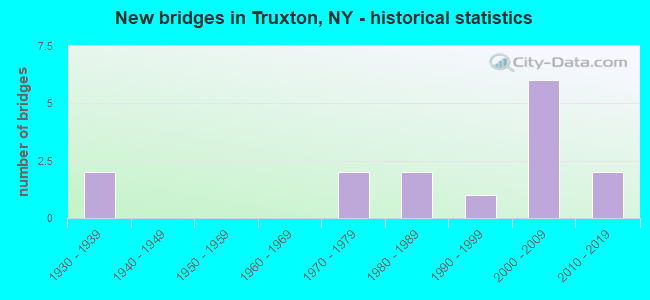
- New bridges - historical statistics
- 21930-1939
- 21970-1979
- 21980-1989
- 11990-1999
- 62000-2009
- 22010-2019

- Reconstructed bridges - Historical Statistics
- 11990-1999
- 12000-2009


- Bridge Condition - Deck
- 9.1%Excellent
- 27.3%Very good
- 27.3%Good
- 27.3%Satisfactory
- 9.1%Poor

- Bridge Condition - Superstructure
- 9.1%Excellent
- 18.2%Very good
- 45.5%Good
- 18.2%Fair
- 9.1%Poor

- Bridge Condition - Substructure
- 36.4%Very good
- 27.3%Good
- 18.2%Satisfactory
- 9.1%Fair
- 9.1%Poor

- Bridge Condition - Channel
- 20.0%Good
- 13.3%Satisfactory
- 46.7%Fair
- 20.0%Poor

- Bridge Condition - Culverts
- 75.0%Very good
- 25.0%Poor
Find on map >> Show street view
Structure Number: 101047, Location: 1.5 MI S JCT RTS 13 + 91 (Lat: 42.696194, Lng: -76.046056), Route carried "on" structure: State highway 13, Year Built: 2007, Status: Open, Structure Length: 1.83m (6.00ft), Average Daily Traffic: 3,005 (year 2020), Truck Traffic: 15%, Average Future Daily Traffic: 3,023 (year 2040), Design Load: HS 25 or greater, Features Intersected: KENNEY BROOK
Minimum Vertical Clearance: 30+ m (98+ ft), Kilometerpoint: 25.647, Lanes on structure: 2, Base Highway Network: Yes, Owner: State Highway Agency, Approaching Roadway Width: 10.4m (34.1ft), Skew: 4 degrees, Material/Design: Prestressed concrete, Design/Construction: Box Beam or Girders - Multiple, Number Of Spans In Main Unit: 1, Length of Maximum Span: 16.8m (55.1ft), Curb-To-Curb Width: 10.4m (34.1ft), Out-to-Out Width: 11.4m (37.4ft)
Condition: Deck: Good, Superstructure: Good, Substructure: Very good, Channel: Fair, Operating Rating: 98.9 metric tons, Method Used To Determine Operating Rating: Load Factor (LF), Inventory Rating: 58.1 metric tons, Method Used To Determine Inventory Rating: Load Factor (LF), Structural Evaluation: Better than present minimum criteria, Deck Geometry: Somewhat better than minimum adequacy, Waterway Adequacy: Meets minimum limits, Approach Roadway Alignment: Equal to present desirable criteria, Length Of Structure Improvement: 1.82m (5.97ft), Designated Inspection Frequency: Every 24 months, Inspection Date: December 2021, Bridge Improvement Cost: $732,000, Roadway Improvement Cost: $428,000, Total Project Cost: $1,160,000 ( Estimate for 2021), Deck Structure Type: Concrete Cast-file-Place, Wearing Surface/Protective System: Wearing Surface: Integral Concrete, Deck Protection: Epoxy Coated Reinforcing
Find on map >> Show street view
Structure Number: 101048, Location: 0.1 MI W JCT RTS 13 & 91 (Lat: 42.711939, Lng: -76.030597), Route carried "on" structure: State highway 13, Year Built: 1999, Status: Open, Structure Length: 1.01m (3.31ft), Average Daily Traffic: 3,005 (year 2020), Truck Traffic: 15%, Average Future Daily Traffic: 3,023 (year 2040), Design Load: HS 25 or greater, Features Intersected: LABRADOR CREEK
Minimum Vertical Clearance: 30+ m (98+ ft), Kilometerpoint: 27.884, Lanes on structure: 2, Base Highway Network: Yes, Owner: State Highway Agency, Approaching Roadway Width: 14.0m (45.9ft), Skew: 1 degrees, Material/Design: Concrete, Design/Construction: Frame, Number Of Spans In Main Unit: 1, Length of Maximum Span: 9.1m (29.9ft), Curb or Sidewalk Widths: Left: 1.5m (4.9ft), Right: 1.5m (4.9ft), Curb-To-Curb Width: 14.0m (45.9ft), Out-to-Out Width: 18.1m (59.4ft)
Condition: Deck: Good, Superstructure: Good, Substructure: Very good, Channel: Satisfactory, Operating Rating: 71.7 metric tons, Method Used To Determine Operating Rating: Load Factor (LF), Inventory Rating: 42.6 metric tons, Method Used To Determine Inventory Rating: Load Factor (LF), Structural Evaluation: Better than present minimum criteria, Deck Geometry: Superior to present desirable criteria, Waterway Adequacy: Meets minimum limits, Approach Roadway Alignment: Equal to present desirable criteria, Length Of Structure Improvement: 1.00m (3.28ft), Designated Inspection Frequency: Every 24 months, Inspection Date: August 2021, Bridge Improvement Cost: $578,000, Roadway Improvement Cost: $339,000, Total Project Cost: $917,000 ( Estimate for 2021), Wearing Surface/Protective System: Wearing Surface: Bituminous
Find on map >> Show street view
Structure Number: 101049, Location: 1.2 MI E JCT RTS 13 + 91 (Lat: 42.712214, Lng: -76.003083), Route carried "on" structure: State highway 13, Year Built: 2007, Status: Open, Structure Length: 0.85m (2.79ft), Average Daily Traffic: 1,703 (year 2020), Truck Traffic: 23%, Average Future Daily Traffic: 1,713 (year 2040), Design Load: HS 25 or greater, Features Intersected: MORGAN HILL CREEK
Minimum Vertical Clearance: 30+ m (98+ ft), Kilometerpoint: 30.153, Lanes on structure: 2, Base Highway Network: Yes, Owner: State Highway Agency, Approaching Roadway Width: 11.0m (36.1ft), Skew: 2 degrees, Material/Design: Concrete, Design/Construction: Culvert, Number Of Spans In Main Unit: 1, Length of Maximum Span: 7.3m (24.0ft), Curb or Sidewalk Widths: Left: 0.0m, Right: 4.2m (13.8ft), Curb-To-Curb Width: 10.9m (35.8ft), Out-to-Out Width: 16.2m (53.1ft)
Condition: Channel: Satisfactory, Culverts: Very good, Operating Rating: 78.0 metric tons, Method Used To Determine Operating Rating: Load Factor (LF), Inventory Rating: 46.3 metric tons, Method Used To Determine Inventory Rating: Load Factor (LF), Structural Evaluation: Equal to present desirable criteria, Deck Geometry: Equal to present minimum criteria, Waterway Adequacy: Somewhat better than minimum adequacy, Approach Roadway Alignment: Equal to present desirable criteria, Length Of Structure Improvement: 0.85m (2.79ft), Designated Inspection Frequency: Every 24 months, Inspection Date: September 2021, Bridge Improvement Cost: $320,000, Roadway Improvement Cost: $187,000, Total Project Cost: $507,000 ( Estimate for 2021), Wearing Surface/Protective System: Wearing Surface: Bituminous
Find on map >> Show street view
Structure Number: 103457, Location: AT CHENINGO (Lat: 42.658969, Lng: -75.997936), Route carried "on" structure: County highway , Year Built: 1934, Status: Open, Structure Length: 1.22m (4.00ft), Average Daily Traffic: 90 (year 2018), Truck Traffic: 8%, Average Future Daily Traffic: 126 (year 2038), Design Load: HS 20, Features Intersected: E BR CHENINGO CRK, Facility Carried by Structure: TAYLOR VALLEY RD
Minimum Vertical Clearance: 30+ m (98+ ft), Kilometerpoint: 15.269, Lanes on structure: 2, Owner: County Highway Agency, Approaching Roadway Width: 7.0m (23.0ft), Material/Design: Steel, Design/Construction: Stringer/Multi-beam, Number Of Spans In Main Unit: 1, Length of Maximum Span: 11.8m (38.7ft), Curb-To-Curb Width: 7.9m (25.9ft), Out-to-Out Width: 8.8m (28.9ft)
Condition: Deck: Satisfactory, Superstructure: Fair, Substructure: Fair, Channel: Fair, Operating Rating: 38.6 metric tons, Method Used To Determine Operating Rating: Load and Resistance Factor Rating (LRFR) rating reported by rating factor(RF) method using HL-93 loadings, Inventory Rating: 29.8 metric tons, Method Used To Determine Inventory Rating: Load and Resistance Factor Rating (LRFR) rating reported by rating factor(RF) method using HL-93 loadings, Structural Evaluation: Somewhat better than minimum adequacy, Deck Geometry: Equal to present minimum criteria, Waterway Adequacy: Meets minimum limits, Approach Roadway Alignment: Equal to present desirable criteria, Length Of Structure Improvement: 1.21m (3.97ft), Designated Inspection Frequency: Every 24 months, Inspection Date: March 2021, Bridge Improvement Cost: $390,000, Roadway Improvement Cost: $228,000, Total Project Cost: $618,000 ( Estimate for 2021), Deck Structure Type: Concrete Cast-file-Place, Wearing Surface/Protective System: Wearing Surface: Bituminous
Find on map >> Show street view
Structure Number: 103458, Location: AT TRUXTON (Lat: 42.709525, Lng: -76.028475), Route carried "on" structure: County highway , Year Built: 2013, Status: Open, Structure Length: 3.47m (11.38ft), Average Daily Traffic: 375 (year 2017), Truck Traffic: 8%, Average Future Daily Traffic: 525 (year 2037), Design Load: HL 93, Features Intersected: E B TIOUGHNIOGA R, Facility Carried by Structure: CHENINGO ROAD
Minimum Vertical Clearance: 30+ m (98+ ft), Kilometerpoint: 5.551, Lanes on structure: 2, Owner: County Highway Agency, Approaching Roadway Width: 9.1m (29.9ft), Material/Design: Steel, Design/Construction: Stringer/Multi-beam, Number Of Spans In Main Unit: 1, Length of Maximum Span: 34.1m (111.9ft), Curb-To-Curb Width: 9.1m (29.9ft), Out-to-Out Width: 10.1m (33.1ft)
Condition: Deck: Excellent, Superstructure: Excellent, Substructure: Good, Channel: Fair, Operating Rating: 90.7 metric tons, Method Used To Determine Operating Rating: Load Factor (LF), Inventory Rating: 54.4 metric tons, Method Used To Determine Inventory Rating: Load Factor (LF), Structural Evaluation: Better than present minimum criteria, Deck Geometry: Equal to present minimum criteria, Waterway Adequacy: Equal to present minimum criteria, Approach Roadway Alignment: Equal to present desirable criteria, Length Of Structure Improvement: 3.47m (11.38ft), Designated Inspection Frequency: Every 24 months, Inspection Date: November 2021, Bridge Improvement Cost: $772,000, Roadway Improvement Cost: $452,000, Total Project Cost: $1,224,000 ( Estimate for 2021), Deck Structure Type: Concrete Cast-file-Place, Wearing Surface/Protective System: Wearing Surface: Integral Concrete, Deck Protection: Galvanized Reinforcing
Find on map >> Show street view
Structure Number: 103459, Location: JCT RTS 13 + 91 (Lat: 42.713317, Lng: -76.025931), Route carried "on" structure: State highway 91, Year Built: 2006, Status: Open, Structure Length: 1.89m (6.20ft), Average Daily Traffic: 448 (year 2016), Truck Traffic: 13%, Average Future Daily Traffic: 627 (year 2036), Design Load: HL 93, Features Intersected: LABRADOR CREEK
Minimum Vertical Clearance: 30+ m (98+ ft), Kilometerpoint: 0.145, Lanes on structure: 2, Base Highway Network: Yes, Owner: State Highway Agency, Approaching Roadway Width: 9.1m (29.9ft), Skew: 3 degrees, Material/Design: Prestressed concrete, Design/Construction: Box Beam or Girders - Multiple, Number Of Spans In Main Unit: 1, Length of Maximum Span: 17.6m (57.7ft), Curb-To-Curb Width: 9.2m (30.2ft), Out-to-Out Width: 10.2m (33.5ft)
Condition: Deck: Good, Superstructure: Very good, Substructure: Very good, Channel: Good, Operating Rating: 95.9 metric tons, Method Used To Determine Operating Rating: Load and Resistance Factor Rating (LRFR) rating reported by rating factor(RF) method using HL-93 loadings, Inventory Rating: 72.9 metric tons, Method Used To Determine Inventory Rating: Load and Resistance Factor Rating (LRFR) rating reported by rating factor(RF) method using HL-93 loadings, Structural Evaluation: Equal to present desirable criteria, Deck Geometry: Equal to present minimum criteria, Waterway Adequacy: Somewhat better than minimum adequacy, Approach Roadway Alignment: Equal to present desirable criteria, Length Of Structure Improvement: 1.88m (6.17ft), Designated Inspection Frequency: Every 24 months, Inspection Date: July 2020, Bridge Improvement Cost: $529,000, Roadway Improvement Cost: $310,000, Total Project Cost: $839,000 ( Estimate for 2021), Wearing Surface/Protective System: Wearing Surface: Monolithic Concrete
Find on map >> Show street view
Structure Number: 10346, Location: 3.1 MI N JCT RTS 91 + 13 (Lat: 42.755458, Lng: -76.030311), Route carried "on" structure: State highway 91, Year Built: 2006, Status: Open, Structure Length: 0.91m (2.99ft), Average Daily Traffic: 448 (year 2016), Truck Traffic: 13%, Average Future Daily Traffic: 627 (year 2036), Design Load: HS 25 or greater, Features Intersected: LABRADOR CREEK
Minimum Vertical Clearance: 30+ m (98+ ft), Kilometerpoint: 4.924, Lanes on structure: 2, Base Highway Network: Yes, Owner: State Highway Agency, Approaching Roadway Width: 9.1m (29.9ft), Skew: 3 degrees, Material/Design: Concrete, Design/Construction: Culvert, Number Of Spans In Main Unit: 1, Length of Maximum Span: 7.0m (23.0ft), Curb-To-Curb Width: 9.2m (30.2ft), Out-to-Out Width: 10.2m (33.5ft)
Condition: Channel: Poor, Culverts: Very good, Operating Rating: 82.0 metric tons, Method Used To Determine Operating Rating: Load Factor (LF), Inventory Rating: 49.0 metric tons, Method Used To Determine Inventory Rating: Load Factor (LF), Structural Evaluation: Equal to present desirable criteria, Deck Geometry: Equal to present minimum criteria, Waterway Adequacy: Meets minimum limits, Approach Roadway Alignment: Meets minimum limits, Length Of Structure Improvement: 0.91m (2.99ft), Designated Inspection Frequency: Every 24 months, Inspection Date: July 2020, Bridge Improvement Cost: $549,000, Roadway Improvement Cost: $322,000, Total Project Cost: $871,000 ( Estimate for 2021), Wearing Surface/Protective System: Wearing Surface: Bituminous, Membrane: Other
Find on map >> Show street view
Structure Number: 103461, Location: 3.4 MI N JCT RTS 91 + 13 (Lat: 42.760253, Lng: -76.026911), Route carried "on" structure: State highway 91, Year Built: 2006, Status: Open, Structure Length: 1.16m (3.81ft), Average Daily Traffic: 448 (year 2016), Truck Traffic: 13%, Average Future Daily Traffic: 627 (year 2036), Design Load: HS 25 or greater, Features Intersected: SHACKHAM BROOK
Minimum Vertical Clearance: 30+ m (98+ ft), Kilometerpoint: 5.519, Lanes on structure: 2, Base Highway Network: Yes, Owner: State Highway Agency, Approaching Roadway Width: 9.1m (29.9ft), Skew: 1 degrees, Material/Design: Concrete, Design/Construction: Culvert, Number Of Spans In Main Unit: 1, Length of Maximum Span: 8.5m (27.9ft), Curb-To-Curb Width: 9.1m (29.9ft), Out-to-Out Width: 10.1m (33.1ft)
Condition: Channel: Poor, Culverts: Very good, Operating Rating: 82.0 metric tons, Method Used To Determine Operating Rating: Load Factor (LF), Inventory Rating: 52.0 metric tons, Method Used To Determine Inventory Rating: Load Factor (LF), Structural Evaluation: Equal to present desirable criteria, Deck Geometry: Equal to present minimum criteria, Waterway Adequacy: Meets minimum limits, Approach Roadway Alignment: Equal to present desirable criteria, Length Of Structure Improvement: 1.15m (3.77ft), Designated Inspection Frequency: Every 24 months, Inspection Date: July 2020, Bridge Improvement Cost: $540,000, Roadway Improvement Cost: $316,000, Total Project Cost: $855,000 ( Estimate for 2021), Wearing Surface/Protective System: Wearing Surface: Monolithic Concrete
Find on map >> Show street view
Structure Number: 220757, Location: 9.0 MI E OF HOMER (Lat: 42.656633, Lng: -76.004886), Route carried "on" structure: Other road , Year Built: 1970, Year Reconstructed: 2001, Status: Open, Structure Length: 0.82m (2.69ft), Average Daily Traffic: 129 (year 2018), Truck Traffic: 1%, Average Future Daily Traffic: 181 (year 2038), Features Intersected: CHENINGO CREEK, Facility Carried by Structure: WEST CHENINGO RD
Minimum Vertical Clearance: 30+ m (98+ ft), Kilometerpoint: 4.570, Lanes on structure: 2, Owner: Town or Township Highway Agency, Approaching Roadway Width: 5.2m (17.1ft), Material/Design: Steel, Design/Construction: Stringer/Multi-beam, Number Of Spans In Main Unit: 1, Length of Maximum Span: 7.9m (25.9ft), Curb-To-Curb Width: 6.1m (20.0ft), Out-to-Out Width: 6.5m (21.3ft)
Condition: Deck: Very good, Superstructure: Good, Substructure: Satisfactory, Channel: Poor, Operating Rating: 47.2 metric tons, Method Used To Determine Operating Rating: Allowable Stress (AS), Inventory Rating: 34.5 metric tons, Method Used To Determine Inventory Rating: Allowable Stress (AS), Structural Evaluation: Equal to present minimum criteria, Deck Geometry: Meets minimum limits, Waterway Adequacy: Superior to present desirable criteria, Approach Roadway Alignment: Better than present minimum criteria, Length Of Structure Improvement: 0.82m (2.69ft), Designated Inspection Frequency: Every 24 months, Underwater Inspection Frequency: Every 60 months, Inspection Date: May 2020, Underwater Inspection Date: July 2021, Bridge Improvement Cost: $255,000, Roadway Improvement Cost: $150,000, Total Project Cost: $405,000 ( Estimate for 2021), Deck Structure Type: Wood or Timber, Wearing Surface/Protective System: Wearing Surface: Wood or Timber
Find on map >> Show street view
Structure Number: 220758, Location: 0.4 MI. E. OF CHENINGO (Lat: 42.661886, Lng: -75.991467), Route carried "on" structure: Other road , Year Built: 1986, Status: Open, Structure Length: 0.79m (2.59ft), Average Daily Traffic: 11 (year 2017), Truck Traffic: 8%, Average Future Daily Traffic: 15 (year 2037), Features Intersected: CHENINGO CREEK, Facility Carried by Structure: ANGEL ROAD
Minimum Vertical Clearance: 30+ m (98+ ft), Kilometerpoint: 0.032, Lanes on structure: 1, Owner: Town or Township Highway Agency, Approaching Roadway Width: 5.5m (18.0ft), Skew: 3 degrees, Material/Design: Wood or Timber, Number Of Spans In Main Unit: 1, Length of Maximum Span: 7.6m (24.9ft), Curb-To-Curb Width: 4.8m (15.7ft), Out-to-Out Width: 5.3m (17.4ft)
Condition: Deck: Satisfactory, Superstructure: Good, Substructure: Good, Channel: Good, Operating Rating: 78.0 metric tons, Method Used To Determine Operating Rating: Field evaluation and documented engineering judgment, Inventory Rating: 32.7 metric tons, Method Used To Determine Inventory Rating: Field evaluation and documented engineering judgment, Structural Evaluation: Better than present minimum criteria, Deck Geometry: Equal to present desirable criteria, Waterway Adequacy: Meets minimum limits, Approach Roadway Alignment: Meets minimum limits, Length Of Structure Improvement: 0.79m (2.59ft), Designated Inspection Frequency: Every 24 months, Inspection Date: October 2020, Bridge Improvement Cost: $212,000, Roadway Improvement Cost: $124,000, Total Project Cost: $337,000 ( Estimate for 2021), Wearing Surface/Protective System: Wearing Surface: Wood or Timber
Find on map >> Show street view
Structure Number: 22686, Location: 1.5 MI N TRUXTON ON 91 (Lat: 42.733081, Lng: -76.027500), Route carried "on" structure: ServiceOther road , Year Built: 1981, Status: Open, Structure Length: 0.70m (2.30ft), Average Daily Traffic: 42 (year 2017), Truck Traffic: 8%, Average Future Daily Traffic: 59 (year 2037), Features Intersected: LABRADOR CREEK, Facility Carried by Structure: ROBINS ROAD
Minimum Vertical Clearance: 30+ m (98+ ft), Kilometerpoint: 0.097, Lanes on structure: 2, Owner: Town or Township Highway Agency, Approaching Roadway Width: 6.7m (22.0ft), Material/Design: Steel, Design/Construction: Culvert, Number Of Spans In Main Unit: 3, Length of Maximum Span: 2.4m (7.9ft), Curb-To-Curb Width: 8.8m (28.9ft), Out-to-Out Width: 9.8m (32.2ft)
Condition: Channel: Fair, Culverts: Poor, Operating Rating: 73.3 metric tons, Method Used To Determine Operating Rating: Field evaluation and documented engineering judgment, Inventory Rating: 19.6 metric tons, Method Used To Determine Inventory Rating: Field evaluation and documented engineering judgment, Structural Evaluation: Meets minimum limits, Deck Geometry: Better than present minimum criteria, Waterway Adequacy: Equal to present minimum criteria, Approach Roadway Alignment: Equal to present desirable criteria, Length Of Structure Improvement: 0.70m (2.30ft), Designated Inspection Frequency: Every 12 months, Inspection Date: August 2021, Bridge Improvement Cost: $158,000, Roadway Improvement Cost: $93,000, Total Project Cost: $251,000 ( Estimate for 2021)
Find on map >> Show street view
Structure Number: 331228, Location: 2.4 MILES SW OF TRUXTON (Lat: 42.678608, Lng: -76.045944), Route carried "on" structure: County highway , Year Built: 2006, Status: Open, Structure Length: 2.13m (6.99ft), Average Daily Traffic: 260 (year 2019), Truck Traffic: 8%, Average Future Daily Traffic: 364 (year 2039), Features Intersected: CHENINGO CREEK, Facility Carried by Structure: COUNTY ROAD 114
Minimum Vertical Clearance: 30+ m (98+ ft), Kilometerpoint: 13.805, Lanes on structure: 2, Owner: County Highway Agency, Approaching Roadway Width: 10.1m (33.1ft), Skew: 3 degrees, Material/Design: Steel, Design/Construction: Stringer/Multi-beam, Number Of Spans In Main Unit: 1, Length of Maximum Span: 19.8m (65.0ft), Curb-To-Curb Width: 9.1m (29.9ft), Out-to-Out Width: 9.8m (32.2ft)
Condition: Deck: Very good, Superstructure: Good, Substructure: Very good, Channel: Good, Operating Rating: 79.8 metric tons, Method Used To Determine Operating Rating: Load Factor (LF), Inventory Rating: 48.1 metric tons, Method Used To Determine Inventory Rating: Load Factor (LF), Structural Evaluation: Better than present minimum criteria, Deck Geometry: Equal to present minimum criteria, Waterway Adequacy: Better than present minimum criteria, Approach Roadway Alignment: Equal to present desirable criteria, Length Of Structure Improvement: 2.13m (6.99ft), Designated Inspection Frequency: Every 24 months, Inspection Date: October 2020, Bridge Improvement Cost: $552,000, Roadway Improvement Cost: $323,000, Total Project Cost: $875,000 ( Estimate for 2021), Deck Structure Type: Concrete Cast-file-Place, Wearing Surface/Protective System: Wearing Surface: Integral Concrete, Deck Protection: Epoxy Coated Reinforcing
Find on map >> Show street view
Structure Number: 33124, Location: 1.3 MI E OF TRUXTON (Lat: 42.710439, Lng: -76.005264), Route carried "on" structure: County highway , Year Built: 1973, Year Reconstructed: 2012, Status: Open, Structure Length: 3.14m (10.30ft), Average Daily Traffic: 344 (year 2020), Truck Traffic: 8%, Average Future Daily Traffic: 482 (year 2040), Features Intersected: E B TIOUGHNIOGA R, Facility Carried by Structure: CRAINS MILL ROAD
Minimum Vertical Clearance: 30+ m (98+ ft), Kilometerpoint: 0.209, Lanes on structure: 2, Owner: County Highway Agency, Approaching Roadway Width: 6.4m (21.0ft), Material/Design: Steel, Design/Construction: Stringer/Multi-beam, Number Of Spans In Main Unit: 2, Length of Maximum Span: 15.2m (49.9ft), Curb-To-Curb Width: 7.3m (24.0ft), Out-to-Out Width: 7.5m (24.6ft)
Condition: Deck: Satisfactory, Superstructure: Fair, Substructure: Satisfactory, Channel: Fair, Operating Rating: 35.4 metric tons, Method Used To Determine Operating Rating: Load Testing, Inventory Rating: 20.9 metric tons, Method Used To Determine Inventory Rating: Load Testing, Structural Evaluation: Somewhat better than minimum adequacy, Deck Geometry: Somewhat better than minimum adequacy, Waterway Adequacy: Better than present minimum criteria, Approach Roadway Alignment: Equal to present desirable criteria, Length Of Structure Improvement: 3.13m (10.27ft), Designated Inspection Frequency: Every 24 months, Inspection Date: June 2021, Bridge Improvement Cost: $610,000, Roadway Improvement Cost: $357,000, Total Project Cost: $967,000 ( Estimate for 2021), Deck Structure Type: Wood or Timber, Wearing Surface/Protective System: Wearing Surface: Bituminous
Find on map >> Show street view
Structure Number: 336748, Location: VILLAGE OF TRUXTON (Lat: 42.712419, Lng: -76.029458), Route carried "on" structure: Other road , Year Built: 1931, Status: Open, Structure Length: 0.76m (2.49ft), Average Daily Traffic: 117 (year 2019), Truck Traffic: 8%, Average Future Daily Traffic: 164 (year 2039), Features Intersected: LABRADOR CREEK, Facility Carried by Structure: PROSPECT STREET
Minimum Vertical Clearance: 30+ m (98+ ft), Kilometerpoint: 0.032, Lanes on structure: 2, Owner: County Highway Agency, Approaching Roadway Width: 6.1m (20.0ft), Material/Design: Concrete, Design/Construction: Slab, Number Of Spans In Main Unit: 1, Length of Maximum Span: 7.3m (24.0ft), Curb or Sidewalk Widths: Left: 2.5m (8.2ft), Right: 0.0m, Curb-To-Curb Width: 6.5m (21.3ft), Out-to-Out Width: 9.7m (31.8ft)
Condition: Deck: Poor, Superstructure: Poor, Substructure: Poor, Channel: Fair, Operating Rating: 74.4 metric tons, Method Used To Determine Operating Rating: Field evaluation and documented engineering judgment, Inventory Rating: 29.4 metric tons, Method Used To Determine Inventory Rating: Field evaluation and documented engineering judgment, Structural Evaluation: Meets minimum limits, Deck Geometry: Meets minimum limits, Waterway Adequacy: Better than present minimum criteria, Approach Roadway Alignment: Equal to present desirable criteria, Length Of Structure Improvement: 0.76m (2.49ft), Designated Inspection Frequency: Every 24 months, Inspection Date: September 2021, Bridge Improvement Cost: $289,000, Roadway Improvement Cost: $169,000, Total Project Cost: $458,000 ( Estimate for 2021), Wearing Surface/Protective System: Wearing Surface: Bituminous
Find on map >> Show street view
Structure Number: 337104, Location: 4.6 mi SE Jct Cheningo Rd (Lat: 42.660772, Lng: -75.997483), Route carried "on" structure: County highway , Year Built: 2013, Status: Open, Structure Length: 0.82m (2.69ft), Design Load: HS 25 or greater, Features Intersected: CHENINGO CREEK TR, Facility Carried by Structure: CHENINGO SOLON PO
Minimum Vertical Clearance: 30+ m (98+ ft), Kilometerpoint: 16.685, Lanes on structure: 2, Owner: County Highway Agency, Approaching Roadway Width: 9.4m (30.8ft), Material/Design: Prestressed concrete, Design/Construction: Box Beam or Girders - Multiple, Number Of Spans In Main Unit: 1, Length of Maximum Span: 7.6m (24.9ft), Curb-To-Curb Width: 9.5m (31.2ft), Out-to-Out Width: 10.5m (34.4ft)
Condition: Deck: Very good, Superstructure: Very good, Substructure: Good, Channel: Fair, Operating Rating: 93.4 metric tons, Method Used To Determine Operating Rating: Load Factor (LF), Inventory Rating: 56.2 metric tons, Method Used To Determine Inventory Rating: Load Factor (LF), Structural Evaluation: Better than present minimum criteria, Deck Geometry: Better than present minimum criteria, Waterway Adequacy: Somewhat better than minimum adequacy, Approach Roadway Alignment: Equal to present minimum criteria, Length Of Structure Improvement: 0.82m (2.69ft), Designated Inspection Frequency: Every 24 months, Inspection Date: October 2021, Bridge Improvement Cost: $330,000, Roadway Improvement Cost: $193,000, Total Project Cost: $523,000 ( Estimate for 2021), Wearing Surface/Protective System: Wearing Surface: Bituminous, Membrane: Other