Bridge Statistics for Thompson, North Dakota (ND)
Condition, Traffic, Stress, Structural Evaluation, Project Costs
- National Bridge Inventory (NBI) Statistics
- 33Number of bridges
- 167ft / 50.9mTotal length
- $825,000Total costs
- 122,937Total average daily traffic
- 20,590Total average daily truck traffic
- National Bridge Inventory (NBI) Registered Bridges for Thompson
- No street view available for this location
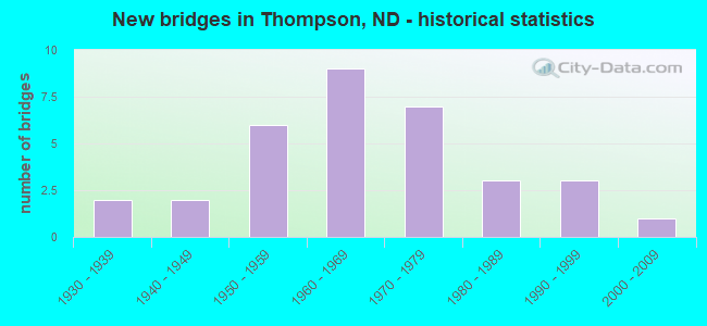
- New bridges - historical statistics
- 21930-1939
- 21940-1949
- 61950-1959
- 91960-1969
- 71970-1979
- 31980-1989
- 31990-1999
- 12000-2009

- Reconstructed bridges - Historical Statistics
- 11970-1979
- 31980-1989
- 01990-1999
- 22000-2009


- Bridge Condition - Deck
- 7.1%Very good
- 57.1%Good
- 28.6%Satisfactory
- 7.1%Fair

- Bridge Condition - Superstructure
- 14.3%Very good
- 42.9%Good
- 28.6%Satisfactory
- 7.1%Fair
- 7.1%Poor

- Bridge Condition - Substructure
- 7.1%Very good
- 42.9%Good
- 28.6%Satisfactory
- 21.4%Fair

- Bridge Condition - Channel
- 52.4%Good
- 33.3%Satisfactory
- 14.3%Fair

- Bridge Condition - Culverts
- 9.1%Very good
- 54.5%Good
- 36.4%Satisfactory
Find on map >> Show street view
Structure Number: 1813428, Location: 3 WEST 3 SOUTH MERRIFIELD (Lat: 47.799731, Lng: -97.174631), Route carried "on" structure: County highway 1833, Year Built: 1995, Status: Open, Structure Length: 0.67m (2.20ft), Average Daily Traffic: 120 (year 2013), Truck Traffic: 10%, Average Future Daily Traffic: 120 (year 2033), Design Load: HS 25 or greater, Features Intersected: DRAIN, Facility Carried by Structure: COUNTY HIGHWAY
Minimum Vertical Clearance: 30+ m (98+ ft), Kilometerpoint: 14.159, Lanes on structure: 2, Owner: County Highway Agency, Approaching Roadway Width: 7.9m (25.9ft), Material/Design: Concrete, Design/Construction: Culvert, Number Of Spans In Main Unit: 2, Length of Maximum Span: 3.0m (9.8ft)
Condition: Channel: Good, Culverts: Good, Operating Rating: 67.5 metric tons, Method Used To Determine Operating Rating: Load Factor (LF), Inventory Rating: 40.5 metric tons, Method Used To Determine Inventory Rating: Load Factor (LF), Structural Evaluation: Better than present minimum criteria, Waterway Adequacy: Equal to present desirable criteria, Approach Roadway Alignment: Equal to present desirable criteria, Designated Inspection Frequency: Every 48 months, Inspection Date: June 2021
Find on map >> Show street view
Structure Number: 181343, Location: 3 WEST 1 SOUTH THOMPSON (Lat: 47.761308, Lng: -97.174211), Route carried "on" structure: County highway 1833, Year Built: 1958, Status: Open, Structure Length: 0.91m (2.99ft), Average Daily Traffic: 90 (year 2019), Average Future Daily Traffic: 45 (year 2039), Design Load: H 15, Features Intersected: CREEK, Facility Carried by Structure: COUNTY HIGHWAY
Minimum Vertical Clearance: 30+ m (98+ ft), Kilometerpoint: 9.815, Lanes on structure: 2, Owner: County Highway Agency, Approaching Roadway Width: 7.9m (25.9ft), Material/Design: Steel, Design/Construction: Culvert, Number Of Spans In Main Unit: 2, Length of Maximum Span: 3.7m (12.1ft)
Condition: Channel: Satisfactory, Culverts: Satisfactory, Operating Rating: 40.5 metric tons, Method Used To Determine Operating Rating: Load Factor (LF), Inventory Rating: 24.3 metric tons, Method Used To Determine Inventory Rating: Load Factor (LF), Structural Evaluation: Equal to present minimum criteria, Waterway Adequacy: Better than present minimum criteria, Approach Roadway Alignment: Better than present minimum criteria, Designated Inspection Frequency: Every 24 months, Inspection Date: June 2021
Find on map >> Show street view
Structure Number: 1813527, Location: 2 NORTH 3 WEST THOMPSON (Lat: 47.802472, Lng: -97.171219), Route carried "on" structure: County highway , Year Built: 1995, Status: Open, Structure Length: 0.73m (2.40ft), Average Daily Traffic: 24 (year 2019), Average Future Daily Traffic: 24 (year 2039), Design Load: HS 20, Features Intersected: COULEE, Facility Carried by Structure: COUNTY HIGHWAY
Minimum Vertical Clearance: 30+ m (98+ ft), Kilometerpoint: 0.000, Lanes on structure: 2, Owner: County Highway Agency, Approaching Roadway Width: 5.8m (19.0ft), Material/Design: Steel, Design/Construction: Culvert, Number Of Spans In Main Unit: 2, Length of Maximum Span: 7.3m (24.0ft)
Condition: Channel: Good, Culverts: Satisfactory, Operating Rating: 54.0 metric tons, Method Used To Determine Operating Rating: Load Factor (LF), Inventory Rating: 32.4 metric tons, Method Used To Determine Inventory Rating: Load Factor (LF), Structural Evaluation: Equal to present minimum criteria, Waterway Adequacy: Equal to present minimum criteria, Approach Roadway Alignment: Equal to present desirable criteria, Designated Inspection Frequency: Every 24 months, Inspection Date: June 2021
Find on map >> Show street view
Structure Number: 181353, Location: 1 SOUTH 2 WEST THOMPSON (Lat: 47.760411, Lng: -97.152875), Route carried "on" structure: County highway , Year Built: 1936, Status: Posted for load, Structure Length: 0.91m (2.99ft), Average Daily Traffic: 35 (year 2019), Average Future Daily Traffic: 35 (year 2039), Features Intersected: COULEE, Facility Carried by Structure: COUNTY HIGHWAY
Minimum Vertical Clearance: 30+ m (98+ ft), Kilometerpoint: 0.000, Lanes on structure: 2, Owner: County Highway Agency, Approaching Roadway Width: 6.7m (22.0ft), Material/Design: Steel, Design/Construction: Stringer/Multi-beam, Number Of Spans In Main Unit: 1, Length of Maximum Span: 8.2m (26.9ft), Curb or Sidewalk Widths: Left: 0.2m (0.7ft), Right: 0.2m (0.7ft), Curb-To-Curb Width: 7.0m (23.0ft), Out-to-Out Width: 7.3m (24.0ft)
Condition: Deck: Good, Superstructure: Good, Substructure: Good, Channel: Good, Operating Rating: 22.1 metric tons, Method Used To Determine Operating Rating: Load Factor (LF), Inventory Rating: 13.2 metric tons, Method Used To Determine Inventory Rating: Load Factor (LF), Structural Evaluation: Meets minimum limits, Deck Geometry: Somewhat better than minimum adequacy, Waterway Adequacy: Equal to present desirable criteria, Approach Roadway Alignment: Equal to present desirable criteria, Bridge Posting: Required (Relationship of Operating Rating to Maximum Legal Load: 30.0 - 39.9% below), Length Of Structure Improvement: 0.91m (2.99ft), Designated Inspection Frequency: Every 24 months, Inspection Date: June 2021, Bridge Improvement Cost: $40,000, Roadway Improvement Cost: $4,000, Total Project Cost: $60,000, Deck Structure Type: Wood or Timber, Wearing Surface/Protective System: Wearing Surface: Gravel
Find on map >> Show street view
Structure Number: 181363, Location: 1 SOUTH 1 WEST THOMPSON (Lat: 47.767619, Lng: -97.131403), Route carried "on" structure: County highway , Year Built: 1940, Year Reconstructed: 1986, Status: Posted for load, Structure Length: 1.10m (3.61ft), Average Daily Traffic: 69 (year 2019), Average Future Daily Traffic: 69 (year 2039), Features Intersected: COULEE, Facility Carried by Structure: COUNTY HIGHWAY
Minimum Vertical Clearance: 30+ m (98+ ft), Kilometerpoint: 0.000, Lanes on structure: 2, Owner: County Highway Agency, Approaching Roadway Width: 6.7m (22.0ft), Material/Design: Steel, Design/Construction: Stringer/Multi-beam, Number Of Spans In Main Unit: 1, Length of Maximum Span: 10.1m (33.1ft), Curb or Sidewalk Widths: Left: 0.2m (0.7ft), Right: 0.2m (0.7ft), Curb-To-Curb Width: 8.7m (28.5ft), Out-to-Out Width: 9.1m (29.9ft)
Condition: Deck: Good, Superstructure: Good, Substructure: Fair, Channel: Good, Operating Rating: 28.4 metric tons, Method Used To Determine Operating Rating: Load Factor (LF), Inventory Rating: 17.0 metric tons, Method Used To Determine Inventory Rating: Load Factor (LF), Structural Evaluation: Somewhat better than minimum adequacy, Deck Geometry: Better than present minimum criteria, Waterway Adequacy: Equal to present desirable criteria, Approach Roadway Alignment: Equal to present desirable criteria, Bridge Posting: Required (Relationship of Operating Rating to Maximum Legal Load: 10.0 - 19.9% below), Length Of Structure Improvement: 1.10m (3.61ft), Designated Inspection Frequency: Every 24 months, Inspection Date: June 2021, Bridge Improvement Cost: $27,000, Roadway Improvement Cost: $3,000, Total Project Cost: $41,000, Deck Structure Type: Wood or Timber, Wearing Surface/Protective System: Wearing Surface: Gravel
Find on map >> Show street view
Structure Number: 181373, Location: CITY THOMPSON (Lat: 47.769794, Lng: -97.109908), Route carried "on" structure: County highway , Year Built: 1986, Status: Open, Structure Length: 0.94m (3.08ft), Average Daily Traffic: 275 (year 2013), Truck Traffic: 10%, Average Future Daily Traffic: 275 (year 2033), Design Load: HS 20, Features Intersected: ELM COULEE, Facility Carried by Structure: COUNTY HIGHWAY
Minimum Vertical Clearance: 30+ m (98+ ft), Kilometerpoint: 0.000, Lanes on structure: 2, Owner: County Highway Agency, Approaching Roadway Width: 7.3m (24.0ft), Material/Design: Concrete, Design/Construction: Culvert, Number Of Spans In Main Unit: 3, Length of Maximum Span: 3.0m (9.8ft)
Condition: Channel: Good, Culverts: Good, Operating Rating: 54.0 metric tons, Method Used To Determine Operating Rating: Load Factor (LF), Inventory Rating: 32.4 metric tons, Method Used To Determine Inventory Rating: Load Factor (LF), Structural Evaluation: Better than present minimum criteria, Waterway Adequacy: Equal to present desirable criteria, Approach Roadway Alignment: Equal to present desirable criteria, Designated Inspection Frequency: Every 48 months, Inspection Date: June 2021
Find on map >> Show street view
Structure Number: 18137331, Location: 3 SOUTH THOMPSON (Lat: 47.730022, Lng: -97.109386), Route carried "on" structure: County highway 1817, Year Built: 1950, Status: Open, Structure Length: 1.22m (4.00ft), Average Daily Traffic: 180 (year 2019), Truck Traffic: 12%, Average Future Daily Traffic: 180 (year 2039), Features Intersected: COLE CREEK, Facility Carried by Structure: COUNTY HIGHWAY
Minimum Vertical Clearance: 30+ m (98+ ft), Kilometerpoint: 0.000, Lanes on structure: 2, Owner: County Highway Agency, Approaching Roadway Width: 7.3m (24.0ft), Material/Design: Concrete, Design/Construction: Tee Beam, Number Of Spans In Main Unit: 1, Length of Maximum Span: 10.1m (33.1ft), Curb-To-Curb Width: 9.0m (29.5ft), Out-to-Out Width: 9.1m (29.9ft)
Condition: Deck: Good, Superstructure: Poor, Substructure: Satisfactory, Channel: Satisfactory, Operating Rating: 65.4 metric tons, Method Used To Determine Operating Rating: Load Factor (LF), Inventory Rating: 39.2 metric tons, Method Used To Determine Inventory Rating: Load Factor (LF), Structural Evaluation: Meets minimum limits, Deck Geometry: Equal to present minimum criteria, Waterway Adequacy: Somewhat better than minimum adequacy, Approach Roadway Alignment: Somewhat better than minimum adequacy, Designated Inspection Frequency: Every 24 months, Inspection Date: June 2021, Deck Structure Type: Concrete Cast-file-Place, Wearing Surface/Protective System: Wearing Surface: Gravel
Find on map >> Show street view
Structure Number: 1813829, Location: 1 EAST OF THOMPSON (Lat: 47.775019, Lng: -97.088547), Route carried "on" structure: County highway , Year Built: 2003, Status: Open, Structure Length: 1.22m (4.00ft), Average Daily Traffic: 40 (year 2019), Average Future Daily Traffic: 40 (year 2039), Design Load: HS 25 or greater, Features Intersected: COULEE, Facility Carried by Structure: COUNTY HIGHWAY
Minimum Vertical Clearance: 30+ m (98+ ft), Kilometerpoint: 0.000, Lanes on structure: 2, Owner: County Highway Agency, Approaching Roadway Width: 6.4m (21.0ft), Material/Design: Prestressed concrete, Design/Construction: Box Beam or Girders - Multiple, Number Of Spans In Main Unit: 1, Length of Maximum Span: 11.3m (37.1ft), Curb or Sidewalk Widths: Left: 0.2m (0.7ft), Right: 0.2m (0.7ft), Curb-To-Curb Width: 9.7m (31.8ft), Out-to-Out Width: 10.1m (33.1ft)
Condition: Deck: Satisfactory, Superstructure: Satisfactory, Substructure: Good, Channel: Satisfactory, Operating Rating: 52.1 metric tons, Method Used To Determine Operating Rating: Load Factor (LF), Inventory Rating: 31.2 metric tons, Method Used To Determine Inventory Rating: Load Factor (LF), Structural Evaluation: Equal to present minimum criteria, Deck Geometry: Better than present minimum criteria, Waterway Adequacy: Better than present minimum criteria, Approach Roadway Alignment: Better than present minimum criteria, Designated Inspection Frequency: Every 24 months, Inspection Date: June 2021
Find on map >> Show street view
Structure Number: 1813832, Location: 1 EAST 2 SOUTH THOMPSON (Lat: 47.737744, Lng: -97.088572), Route carried "on" structure: County highway , Year Built: 1955, Status: Open, Structure Length: 0.79m (2.59ft), Average Daily Traffic: 120 (year 2019), Truck Traffic: 12%, Average Future Daily Traffic: 120 (year 2039), Features Intersected: COLE CREEK, Facility Carried by Structure: COUNTY ROAD
Minimum Vertical Clearance: 30+ m (98+ ft), Kilometerpoint: 0.000, Lanes on structure: 2, Owner: County Highway Agency, Approaching Roadway Width: 5.2m (17.1ft), Material/Design: Wood or Timber, Design/Construction: Slab, Number Of Spans In Main Unit: 1, Length of Maximum Span: 7.3m (24.0ft), Curb or Sidewalk Widths: Left: 0.1m (0.3ft), Right: 0.1m (0.3ft), Curb-To-Curb Width: 7.9m (25.9ft), Out-to-Out Width: 8.2m (26.9ft)
Condition: Deck: Satisfactory, Superstructure: Satisfactory, Substructure: Fair, Channel: Fair, Operating Rating: 56.3 metric tons, Method Used To Determine Operating Rating: Allowable Stress (AS), Inventory Rating: 41.2 metric tons, Method Used To Determine Inventory Rating: Allowable Stress (AS), Structural Evaluation: Somewhat better than minimum adequacy, Deck Geometry: Somewhat better than minimum adequacy, Waterway Adequacy: Equal to present minimum criteria, Approach Roadway Alignment: Equal to present desirable criteria, Designated Inspection Frequency: Every 24 months, Inspection Date: June 2021, Deck Structure Type: Wood or Timber, Wearing Surface/Protective System: Wearing Surface: Gravel
Find on map >> Show street view
Structure Number: 1813929, Location: 10 SOUTH OF GRAND FORKS (Lat: 47.785764, Lng: -97.067036), Route carried "on" structure: County highway 1837, Year Built: 1970, Status: Open, Structure Length: 0.64m (2.10ft), Average Daily Traffic: 570 (year 2013), Truck Traffic: 6%, Average Future Daily Traffic: 570 (year 2033), Design Load: HS 20, Features Intersected: CREEK, Facility Carried by Structure: COUNTY HIGHWAY
Minimum Vertical Clearance: 30+ m (98+ ft), Kilometerpoint: 12.550, Lanes on structure: 2, Owner: County Highway Agency, Approaching Roadway Width: 14.6m (47.9ft), Material/Design: Concrete, Design/Construction: Culvert, Number Of Spans In Main Unit: 2, Length of Maximum Span: 3.0m (9.8ft)
Condition: Channel: Satisfactory, Culverts: Satisfactory, Operating Rating: 54.0 metric tons, Method Used To Determine Operating Rating: Load Factor (LF), Inventory Rating: 32.4 metric tons, Method Used To Determine Inventory Rating: Load Factor (LF), Structural Evaluation: Equal to present minimum criteria, Waterway Adequacy: Better than present minimum criteria, Approach Roadway Alignment: Better than present minimum criteria, Designated Inspection Frequency: Every 48 months, Inspection Date: June 2021
Find on map >> Show street view
Structure Number: 1813931, Location: 2 EAST 2 SOUTH THOMPSON (Lat: 47.744742, Lng: -97.070042), Route carried "on" structure: County highway , Year Built: 1989, Status: Posted for load, Structure Length: 1.11m (3.64ft), Average Daily Traffic: 50 (year 2019), Average Future Daily Traffic: 50 (year 2039), Features Intersected: COLE CREEK, Facility Carried by Structure: COUNTY ROAD
Minimum Vertical Clearance: 30+ m (98+ ft), Kilometerpoint: 0.000, Lanes on structure: 2, Owner: County Highway Agency, Approaching Roadway Width: 4.3m (14.1ft), Material/Design: Steel, Design/Construction: Stringer/Multi-beam, Number Of Spans In Main Unit: 1, Length of Maximum Span: 10.7m (35.1ft), Curb-To-Curb Width: 8.6m (28.2ft), Out-to-Out Width: 8.6m (28.2ft)
Condition: Deck: Good, Superstructure: Satisfactory, Substructure: Satisfactory, Channel: Fair, Operating Rating: 24.5 metric tons, Method Used To Determine Operating Rating: Allowable Stress (AS), Inventory Rating: 14.4 metric tons, Method Used To Determine Inventory Rating: Allowable Stress (AS), Structural Evaluation: Meets minimum limits, Deck Geometry: Better than present minimum criteria, Waterway Adequacy: Equal to present desirable criteria, Approach Roadway Alignment: Equal to present desirable criteria, Bridge Posting: Required (Relationship of Operating Rating to Maximum Legal Load: 20.0 - 29.9% below), Length Of Structure Improvement: 1.10m (3.61ft), Designated Inspection Frequency: Every 24 months, Inspection Date: June 2021, Bridge Improvement Cost: $25,000, Roadway Improvement Cost: $3,000, Total Project Cost: $38,000, Deck Structure Type: Wood or Timber, Wearing Surface/Protective System: Wearing Surface: Gravel
Find on map >> Show street view
Structure Number: 18139311, Location: 2 EAST 2 SOUTH THOMPSON (Lat: 47.746719, Lng: -97.066997), Route carried "on" structure: County highway 1837, Year Built: 1936, Status: Open, Structure Length: 0.64m (2.10ft), Average Daily Traffic: 570 (year 2013), Truck Traffic: 12%, Average Future Daily Traffic: 2,250 (year 2033), Design Load: H 15, Features Intersected: COLE CREEK, Facility Carried by Structure: COUNTY HIGHWAY
Minimum Vertical Clearance: 30+ m (98+ ft), Kilometerpoint: 8.206, Lanes on structure: 2, Owner: County Highway Agency, Approaching Roadway Width: 7.0m (23.0ft), Material/Design: Concrete, Design/Construction: Culvert, Number Of Spans In Main Unit: 2, Length of Maximum Span: 3.0m (9.8ft)
Condition: Channel: Good, Culverts: Good, Operating Rating: 40.5 metric tons, Method Used To Determine Operating Rating: Load Factor (LF), Inventory Rating: 24.3 metric tons, Method Used To Determine Inventory Rating: Load Factor (LF), Structural Evaluation: Equal to present minimum criteria, Waterway Adequacy: Better than present minimum criteria, Approach Roadway Alignment: Better than present minimum criteria, Designated Inspection Frequency: Every 24 months, Inspection Date: October 2020
Find on map >> Show street view
Structure Number: 1814028, Location: 2 EAST 1 NORTH THOMPSON (Lat: 47.788303, Lng: -97.063914), Route carried "on" structure: County highway , Year Built: 1999, Status: Open, Structure Length: 0.98m (3.22ft), Average Daily Traffic: 45 (year 2013), Average Future Daily Traffic: 45 (year 2033), Design Load: HS 25 or greater, Features Intersected: COULEE, Facility Carried by Structure: COUNTY HIGHWAY
Minimum Vertical Clearance: 30+ m (98+ ft), Kilometerpoint: 0.000, Lanes on structure: 2, Owner: County Highway Agency, Approaching Roadway Width: 5.5m (18.0ft), Skew: 4 degrees, Material/Design: Concrete, Design/Construction: Culvert, Number Of Spans In Main Unit: 2, Length of Maximum Span: 3.0m (9.8ft)
Condition: Channel: Satisfactory, Culverts: Good, Operating Rating: 67.5 metric tons, Method Used To Determine Operating Rating: Load Factor (LF), Inventory Rating: 40.5 metric tons, Method Used To Determine Inventory Rating: Load Factor (LF), Structural Evaluation: Better than present minimum criteria, Waterway Adequacy: Better than present minimum criteria, Approach Roadway Alignment: Equal to present desirable criteria, Designated Inspection Frequency: Every 48 months, Inspection Date: June 2021
Find on map >> Show street view
Structure Number: 18140281, Location: 3 EAST 2 NORTH THOMPSON (Lat: 47.797753, Lng: -97.045478), Route carried "on" structure: County highway , Year Built: 1989, Status: Open, Structure Length: 0.94m (3.08ft), Average Daily Traffic: 35 (year 2019), Average Future Daily Traffic: 35 (year 2039), Design Load: H 20, Features Intersected: CREEK, Facility Carried by Structure: COUNTY HIGHWAY
Minimum Vertical Clearance: 30+ m (98+ ft), Kilometerpoint: 0.000, Lanes on structure: 2, Owner: County Highway Agency, Approaching Roadway Width: 5.5m (18.0ft), Material/Design: Prestressed concrete, Design/Construction: Tee Beam, Number Of Spans In Main Unit: 1, Length of Maximum Span: 8.5m (27.9ft), Curb-To-Curb Width: 8.4m (27.6ft), Out-to-Out Width: 8.5m (27.9ft)
Condition: Deck: Good, Superstructure: Good, Substructure: Very good, Channel: Satisfactory, Operating Rating: 70.5 metric tons, Method Used To Determine Operating Rating: Load Factor (LF), Inventory Rating: 42.2 metric tons, Method Used To Determine Inventory Rating: Load Factor (LF), Structural Evaluation: Better than present minimum criteria, Deck Geometry: Equal to present minimum criteria, Waterway Adequacy: Equal to present desirable criteria, Approach Roadway Alignment: Equal to present desirable criteria, Designated Inspection Frequency: Every 24 months, Inspection Date: June 2021
Find on map >> Show street view
Structure Number: 18140312, Location: 3 EAST 2 SOUTH THOMPSON (Lat: 47.744742, Lng: -97.045558), Route carried "on" structure: County highway , Year Built: 1940, Year Reconstructed: 1986, Status: Posted for load, Structure Length: 0.74m (2.43ft), Average Daily Traffic: 24 (year 2019), Average Future Daily Traffic: 24 (year 2039), Features Intersected: COUNTY DRAIN 27, Facility Carried by Structure: COUNTY ROAD
Minimum Vertical Clearance: 30+ m (98+ ft), Kilometerpoint: 0.000, Lanes on structure: 2, Owner: County Highway Agency, Approaching Roadway Width: 5.2m (17.1ft), Material/Design: Steel, Design/Construction: Stringer/Multi-beam, Number Of Spans In Main Unit: 1, Length of Maximum Span: 6.9m (22.6ft), Curb-To-Curb Width: 8.4m (27.6ft), Out-to-Out Width: 8.6m (28.2ft)
Condition: Deck: Fair, Superstructure: Fair, Substructure: Good, Channel: Good, Operating Rating: 31.2 metric tons, Method Used To Determine Operating Rating: Load Factor (LF), Inventory Rating: 18.7 metric tons, Method Used To Determine Inventory Rating: Load Factor (LF), Structural Evaluation: Somewhat better than minimum adequacy, Deck Geometry: Equal to present minimum criteria, Waterway Adequacy: Superior to present desirable criteria, Approach Roadway Alignment: Equal to present desirable criteria, Bridge Posting: Required (Relationship of Operating Rating to Maximum Legal Load: 0.1 - 9.9% below), Designated Inspection Frequency: Every 24 months, Inspection Date: June 2021, Deck Structure Type: Wood or Timber, Wearing Surface/Protective System: Wearing Surface: Gravel
Find on map >> Show street view
Structure Number: 18141314, Location: 3 EAST 1 SOUTH THOMPSON (Lat: 47.753153, Lng: -97.038858), Route carried "on" structure: County highway , Year Built: 1951, Year Reconstructed: 1980, Status: Posted for load, Structure Length: 0.92m (3.02ft), Average Daily Traffic: 10 (year 2019), Average Future Daily Traffic: 10 (year 2039), Design Load: H 20, Features Intersected: COLE CREEK, Facility Carried by Structure: COUNTY ROAD
Minimum Vertical Clearance: 30+ m (98+ ft), Kilometerpoint: 0.000, Lanes on structure: 2, Owner: County Highway Agency, Approaching Roadway Width: 4.3m (14.1ft), Material/Design: Steel, Design/Construction: Stringer/Multi-beam, Number Of Spans In Main Unit: 1, Length of Maximum Span: 8.8m (28.9ft), Curb-To-Curb Width: 7.9m (25.9ft), Out-to-Out Width: 7.9m (25.9ft)
Condition: Deck: Good, Superstructure: Satisfactory, Substructure: Good, Channel: Good, Operating Rating: 23.8 metric tons, Method Used To Determine Operating Rating: Load Factor (LF), Inventory Rating: 14.2 metric tons, Method Used To Determine Inventory Rating: Load Factor (LF), Structural Evaluation: Meets minimum limits, Deck Geometry: Equal to present minimum criteria, Waterway Adequacy: Better than present minimum criteria, Approach Roadway Alignment: Better than present minimum criteria, Bridge Posting: Required (Relationship of Operating Rating to Maximum Legal Load: 20.0 - 29.9% below), Length Of Structure Improvement: 0.91m (2.99ft), Designated Inspection Frequency: Every 24 months, Inspection Date: June 2021, Bridge Improvement Cost: $20,000, Roadway Improvement Cost: $2,000, Total Project Cost: $30,000, Deck Structure Type: Wood or Timber, Wearing Surface/Protective System: Wearing Surface: Gravel
Find on map >> Show street view
Structure Number: 15133496, Location: 1 WEST OF I-29 (Lat: 47.773333, Lng: -97.091667), Route carried "on" structure: State highway 15, Year Built: 1955, Year Reconstructed: 2014, Status: Open, Structure Length: 0.88m (2.89ft), Average Daily Traffic: 2,830 (year 2019), Truck Traffic: 11%, Average Future Daily Traffic: 2,830 (year 2039), Design Load: HS 20, Features Intersected: CREEK
Minimum Vertical Clearance: 30+ m (98+ ft), Kilometerpoint: 214.795, Lanes on structure: 2, Base Highway Network: Yes, Owner: State Highway Agency, Approaching Roadway Width: 8.5m (27.9ft), Material/Design: Concrete, Design/Construction: Culvert, Number Of Spans In Main Unit: 3, Length of Maximum Span: 2.7m (8.9ft)
Condition: Channel: Good, Culverts: Satisfactory, Operating Rating: 54.0 metric tons, Method Used To Determine Operating Rating: Load Factor (LF), Inventory Rating: 32.4 metric tons, Method Used To Determine Inventory Rating: Load Factor (LF), Structural Evaluation: Equal to present minimum criteria, Waterway Adequacy: Better than present minimum criteria, Approach Roadway Alignment: Equal to present desirable criteria, Designated Inspection Frequency: Every 48 months, Inspection Date: May 2019
Find on map >> Show street view
Structure Number: 15133708 N, Location: WEST OF I-29 (Lat: 47.773333, Lng: -97.086667), Route carried "on" structure: ServiceCounty highway , Year Built: 1955, Status: Open, Structure Length: 0.94m (3.08ft), Average Daily Traffic: 10 (year 2019), Average Future Daily Traffic: 10 (year 2039), Design Load: H 15, Features Intersected: ELM COULEE, Facility Carried by Structure: APPROACH
Minimum Vertical Clearance: 30+ m (98+ ft), Kilometerpoint: 215.136, Lanes on structure: 2, Owner: State Highway Agency, Approaching Roadway Width: 4.6m (15.1ft), Material/Design: Concrete, Design/Construction: Tee Beam, Number Of Spans In Main Unit: 1, Length of Maximum Span: 8.8m (28.9ft), Curb-To-Curb Width: 4.9m (16.1ft), Out-to-Out Width: 5.4m (17.7ft)
Condition: Deck: Very good, Superstructure: Very good, Substructure: Satisfactory, Channel: Satisfactory, Operating Rating: 64.7 metric tons, Method Used To Determine Operating Rating: Load Factor (LF), Inventory Rating: 38.7 metric tons, Method Used To Determine Inventory Rating: Load Factor (LF), Structural Evaluation: Equal to present minimum criteria, Deck Geometry: High priority of corrective action, Waterway Adequacy: Equal to present desirable criteria, Approach Roadway Alignment: Better than present minimum criteria, Length Of Structure Improvement: 0.94m (3.08ft), Designated Inspection Frequency: Every 24 months, Inspection Date: July 2021, Bridge Improvement Cost: $59,000, Roadway Improvement Cost: $6,000, Total Project Cost: $89,000, Deck Structure Type: Concrete Cast-file-Place, Wearing Surface/Protective System: Wearing Surface: Gravel
Find on map >> Show street view
Structure Number: 29115969, Location: 5 NORTH OF ND 200 (Lat: 47.737097, Lng: -97.080433), Route carried "on" structure: County highway , Year Built: 1970, Status: Open, Structure Length: 8.08m (26.51ft), Average Daily Traffic: 80 (year 2019), Average Future Daily Traffic: 80 (year 2039), Design Load: H 15, Features Intersected: I-29/BUXTON SEPARATION, Facility Carried by Structure: COUNTY HIGHWAY
Minimum Vertical Clearance: 30+ m (98+ ft), Kilometerpoint: 0.000, Lanes on structure: 2, Lanes under structure: 4, Owner: State Highway Agency, Approaching Roadway Width: 12.2m (40.0ft), Material/Design: Steel continuous, Design/Construction: Stringer/Multi-beam, Number Of Spans In Main Unit: 4, Length of Maximum Span: 29.0m (95.1ft), Curb or Sidewalk Widths: Left: 0.4m (1.3ft), Right: 0.4m (1.3ft), Curb-To-Curb Width: 9.1m (29.9ft), Out-to-Out Width: 10.6m (34.8ft)
Condition: Deck: Satisfactory, Superstructure: Good, Substructure: Fair, Operating Rating: 51.4 metric tons, Method Used To Determine Operating Rating: Load Factor (LF), Inventory Rating: 30.8 metric tons, Method Used To Determine Inventory Rating: Load Factor (LF), Structural Evaluation: Somewhat better than minimum adequacy, Deck Geometry: Better than present minimum criteria, Underclear: Somewhat better than minimum adequacy, Approach Roadway Alignment: Equal to present minimum criteria, Designated Inspection Frequency: Every 24 months, Inspection Date: April 2020, Deck Structure Type: Concrete Cast-file-Place, Wearing Surface/Protective System: Wearing Surface: Monolithic Concrete
Find on map >> Show street view
Structure Number: 29116471, Location: 6 NORTH OF ND 200 (Lat: 47.733333, Lng: -97.080000), Route carried "on" structure: Interstate 29, Year Built: 1969, Status: Open, Structure Length: 0.98m (3.22ft), Average Daily Traffic: 9,100 (year 2019), Truck Traffic: 19%, Average Future Daily Traffic: 9,100 (year 2039), Design Load: HS 20, Features Intersected: BRANCH OF BUFFALO COULEE
Minimum Vertical Clearance: 30+ m (98+ ft), Kilometerpoint: 187.402, Lanes on structure: 4, Base Highway Network: Yes, Owner: State Highway Agency, Approaching Roadway Width: 22.6m (74.1ft), Skew: 10 degrees, Material/Design: Concrete, Design/Construction: Culvert, Number Of Spans In Main Unit: 3, Length of Maximum Span: 3.0m (9.8ft)
Condition: Channel: Fair, Culverts: Very good, Operating Rating: 54.0 metric tons, Method Used To Determine Operating Rating: Load Factor (LF), Inventory Rating: 32.4 metric tons, Method Used To Determine Inventory Rating: Load Factor (LF), Structural Evaluation: Equal to present desirable criteria, Waterway Adequacy: Equal to present minimum criteria, Approach Roadway Alignment: Equal to present desirable criteria, Designated Inspection Frequency: Every 24 months, Inspection Date: August 2020
Find on map >> Show street view
Structure Number: 29127036, Location: 3 SOUTH ND 15 (Lat: 47.730000, Lng: -97.075000), Route carried "on" structure: County highway , Year Built: 1970, Status: Open, Structure Length: 8.08m (26.51ft), Average Daily Traffic: 110 (year 2019), Truck Traffic: 14%, Average Future Daily Traffic: 110 (year 2039), Design Load: HS 20, Features Intersected: I-29/NORTHWOOD SEP, Facility Carried by Structure: COUNTY HIGHWAY
Minimum Vertical Clearance: 30+ m (98+ ft), Kilometerpoint: 0.000, Lanes on structure: 2, Lanes under structure: 4, Owner: State Highway Agency, Approaching Roadway Width: 7.3m (24.0ft), Material/Design: Steel, Design/Construction: Stringer/Multi-beam, Number Of Spans In Main Unit: 4, Length of Maximum Span: 28.3m (92.8ft), Curb-To-Curb Width: 9.1m (29.9ft), Out-to-Out Width: 10.6m (34.8ft)
Condition: Deck: Good, Superstructure: Good, Substructure: Good, Operating Rating: 72.8 metric tons, Method Used To Determine Operating Rating: Load Factor (LF), Inventory Rating: 43.6 metric tons, Method Used To Determine Inventory Rating: Load Factor (LF), Structural Evaluation: Better than present minimum criteria, Deck Geometry: Equal to present minimum criteria, Underclear: Somewhat better than minimum adequacy, Approach Roadway Alignment: Better than present minimum criteria, Designated Inspection Frequency: Every 24 months, Inspection Date: April 2020, Deck Structure Type: Concrete Cast-file-Place, Wearing Surface/Protective System: Wearing Surface: Monolithic Concrete
Find on map >> Show street view
Structure Number: 29127746, Location: 2 SOUTH ND 15 (Lat: 47.740436, Lng: -97.077564), Route carried "on" structure: Interstate 29, Year Built: 1969, Year Reconstructed: 2013, Status: Open, Structure Length: 0.64m (2.10ft), Average Daily Traffic: 9,800 (year 2019), Truck Traffic: 18%, Average Future Daily Traffic: 9,800 (year 2039), Design Load: HS 20, Features Intersected: COLE CREEK
Minimum Vertical Clearance: 30+ m (98+ ft), Kilometerpoint: 205.543, Lanes on structure: 4, Base Highway Network: Yes, Owner: State Highway Agency, Approaching Roadway Width: 22.6m (74.1ft), Skew: 10 degrees, Material/Design: Concrete, Design/Construction: Culvert, Number Of Spans In Main Unit: 2, Length of Maximum Span: 3.0m (9.8ft)
Condition: Channel: Good, Culverts: Good, Operating Rating: 54.0 metric tons, Method Used To Determine Operating Rating: Load Factor (LF), Inventory Rating: 32.4 metric tons, Method Used To Determine Inventory Rating: Load Factor (LF), Structural Evaluation: Better than present minimum criteria, Waterway Adequacy: Equal to present desirable criteria, Approach Roadway Alignment: Equal to present desirable criteria, Designated Inspection Frequency: Every 48 months, Inspection Date: July 2019
Find on map >> Show street view
Structure Number: 29130043, Location: JUNCTION ND 15 (Lat: 47.773672, Lng: -97.077756), Route carried "on" structure: State highway 15, Year Built: 1967, Year Reconstructed: 1983, Status: Open, Structure Length: 8.08m (26.51ft), Average Daily Traffic: 2,850 (year 2019), Truck Traffic: 11%, Average Future Daily Traffic: 2,850 (year 2039), Design Load: HS 20, Features Intersected: I-29/THOMPSON INTERCHANG
Minimum Vertical Clearance: 30+ m (98+ ft), Kilometerpoint: 215.826, Lanes on structure: 2, Lanes under structure: 4, Base Highway Network: Yes, Owner: State Highway Agency, Approaching Roadway Width: 7.3m (24.0ft), Material/Design: Steel, Design/Construction: Stringer/Multi-beam, Number Of Spans In Main Unit: 4, Length of Maximum Span: 28.3m (92.8ft), Curb-To-Curb Width: 9.1m (29.9ft), Out-to-Out Width: 10.6m (34.8ft)
Condition: Deck: Good, Superstructure: Good, Substructure: Satisfactory, Operating Rating: 66.8 metric tons, Method Used To Determine Operating Rating: Load Factor (LF), Inventory Rating: 39.9 metric tons, Method Used To Determine Inventory Rating: Load Factor (LF), Structural Evaluation: Equal to present minimum criteria, Deck Geometry: Meets minimum limits, Underclear: Equal to present minimum criteria, Approach Roadway Alignment: Better than present minimum criteria, Length Of Structure Improvement: 8.08m (26.51ft), Designated Inspection Frequency: Every 24 months, Other Special Inspection Frequency: Every 96 months, Inspection Date: April 2020, Other Special Inspection Date: November 2021, Bridge Improvement Cost: $378,000, Roadway Improvement Cost: $38,000, Total Project Cost: $567,000, Deck Structure Type: Concrete Cast-file-Place, Wearing Surface/Protective System: Wearing Surface: Low Slump Concrete
Find on map >> Show street view
Structure Number: 29130293, Location: NORTH OF THOMPSON INTER. (Lat: 47.777350, Lng: -97.077978), Route carried "on" structure: Interstate 29, Year Built: 1967, Status: Open, Structure Length: 0.64m (2.10ft), Average Daily Traffic: 11,600 (year 2019), Truck Traffic: 16%, Average Future Daily Traffic: 11,600 (year 2039), Design Load: HS 20, Features Intersected: CREEK
Minimum Vertical Clearance: 30+ m (98+ ft), Kilometerpoint: 209.641, Lanes on structure: 4, Base Highway Network: Yes, Owner: State Highway Agency, Approaching Roadway Width: 28.3m (92.8ft), Skew: 10 degrees, Material/Design: Concrete, Design/Construction: Culvert, Number Of Spans In Main Unit: 2, Length of Maximum Span: 3.0m (9.8ft)
Condition: Channel: Good, Culverts: Good, Operating Rating: 54.0 metric tons, Method Used To Determine Operating Rating: Load Factor (LF), Inventory Rating: 32.4 metric tons, Method Used To Determine Inventory Rating: Load Factor (LF), Structural Evaluation: Better than present minimum criteria, Waterway Adequacy: Better than present minimum criteria, Approach Roadway Alignment: Equal to present desirable criteria, Designated Inspection Frequency: Every 48 months, Inspection Date: July 2019
Find on map >> Show street view
Structure Number: 2913306, Location: 3 NORTH ND 15 (Lat: 47.816667, Lng: -97.075000), Route carried "on" structure: County highway , Year Built: 1967, Status: Open, Structure Length: 8.08m (26.51ft), Average Daily Traffic: 100 (year 2019), Truck Traffic: 16%, Average Future Daily Traffic: 100 (year 2039), Design Load: HS 20, Features Intersected: I-29/WALLE SEPARATION, Facility Carried by Structure: COUNTY HIGHWAY
Minimum Vertical Clearance: 30+ m (98+ ft), Kilometerpoint: 0.000, Lanes on structure: 2, Lanes under structure: 4, Owner: State Highway Agency, Approaching Roadway Width: 7.3m (24.0ft), Material/Design: Steel, Design/Construction: Stringer/Multi-beam, Number Of Spans In Main Unit: 4, Length of Maximum Span: 28.3m (92.8ft), Curb-To-Curb Width: 7.3m (24.0ft), Out-to-Out Width: 8.8m (28.9ft)
Condition: Deck: Satisfactory, Superstructure: Very good, Substructure: Good, Operating Rating: 55.3 metric tons, Method Used To Determine Operating Rating: Load Factor (LF), Inventory Rating: 33.1 metric tons, Method Used To Determine Inventory Rating: Load Factor (LF), Structural Evaluation: Better than present minimum criteria, Deck Geometry: Equal to present minimum criteria, Underclear: Equal to present minimum criteria, Approach Roadway Alignment: Better than present minimum criteria, Designated Inspection Frequency: Every 24 months, Inspection Date: April 2020, Deck Structure Type: Concrete Cast-file-Place, Wearing Surface/Protective System: Wearing Surface: Monolithic Concrete
Find on map >> Show street view
Structure Number: 29115969, Location: 5 NORTH OF ND 200 (Lat: 47.737097, Lng: -97.080433), Route carried "under" structure: Interstate 29, Year Built: 1970, Structure Length: 0. m, Average Daily Traffic: 9,100 (year 2011), Truck Traffic: 19%, Features Intersected: I-29/BUXTON SEPARATION, Facility Carried by Structure: COUNTY HIGHWAY
Minimum Vertical Clearance: 5.07m (16.63ft), Kilometerpoint: 186.634, Lanes on structure: 2, Lanes under structure: 2, Material/Design: Steel continuous, Design/Construction: Stringer/Multi-beam, Length of Maximum Span: 29.0m (95.1ft)
Find on map >> Show street view
Structure Number: 29115969, Location: 5 NORTH OF ND 200 (Lat: 47.737097, Lng: -97.080433), Route carried "under" structure: Interstate 29, Year Built: 1970, Structure Length: 0. m, Average Daily Traffic: 9,100 (year 2011), Truck Traffic: 19%, Features Intersected: I-29/BUXTON SEPARATION, Facility Carried by Structure: COUNTY HIGHWAY
Minimum Vertical Clearance: 4.97m (16.31ft), Kilometerpoint: 186.634, Lanes on structure: 2, Lanes under structure: 2, Material/Design: Steel continuous, Design/Construction: Stringer/Multi-beam, Length of Maximum Span: 29.0m (95.1ft)
Find on map >> Show street view
Structure Number: 29127036, Location: 3 SOUTH ND 15 (Lat: 47.730000, Lng: -97.075000), Route carried "under" structure: Interstate 29, Year Built: 1970, Structure Length: 0. m, Average Daily Traffic: 9,800 (year 2011), Truck Traffic: 18%, Features Intersected: I-29/NORTHWOOD SEP, Facility Carried by Structure: COUNTY HIGHWAY
Minimum Vertical Clearance: 5.12m (16.80ft), Kilometerpoint: 198.007, Lanes on structure: 2, Lanes under structure: 2, Material/Design: Steel, Design/Construction: Stringer/Multi-beam, Length of Maximum Span: 28.3m (92.8ft)
Find on map >> Show street view
Structure Number: 29127036, Location: 3 SOUTH ND 15 (Lat: 47.730000, Lng: -97.075000), Route carried "under" structure: Interstate 29, Year Built: 1970, Structure Length: 0. m, Average Daily Traffic: 9,800 (year 2011), Truck Traffic: 18%, Features Intersected: I-29/NORTHWOOD SEP, Facility Carried by Structure: COUNTY HIGHWAY
Minimum Vertical Clearance: 5.11m (16.77ft), Kilometerpoint: 204.445, Lanes on structure: 2, Lanes under structure: 2, Material/Design: Steel, Design/Construction: Stringer/Multi-beam, Length of Maximum Span: 28.3m (92.8ft)
Find on map >> Show street view
Structure Number: 29130043, Location: JUNCTION ND 15 (Lat: 47.773672, Lng: -97.077756), Route carried "under" structure: Interstate 29, Year Built: 1967, Structure Length: 0. m, Average Daily Traffic: 11,600 (year 2011), Truck Traffic: 16%, Features Intersected: I-29/THOMPSON INTERCHANG, Facility Carried by Structure: ND HIGHWAY 15
Minimum Vertical Clearance: 5.06m (16.60ft), Kilometerpoint: 209.284, Lanes on structure: 2, Lanes under structure: 2, Material/Design: Steel, Design/Construction: Stringer/Multi-beam, Length of Maximum Span: 28.3m (92.8ft)
Find on map >> Show street view
Structure Number: 29130043, Location: JUNCTION ND 15 (Lat: 47.773672, Lng: -97.077756), Route carried "under" structure: Interstate 29, Year Built: 1967, Structure Length: 0. m, Average Daily Traffic: 11,600 (year 2011), Truck Traffic: 16%, Features Intersected: I-29/THOMPSON INTERCHANG, Facility Carried by Structure: ND HIGHWAY 15
Minimum Vertical Clearance: 5.11m (16.77ft), Kilometerpoint: 209.284, Lanes on structure: 2, Lanes under structure: 2, Material/Design: Steel, Design/Construction: Stringer/Multi-beam, Length of Maximum Span: 28.3m (92.8ft)
Find on map >> Show street view
Structure Number: 2913306, Location: 3 NORTH ND 15 (Lat: 47.816667, Lng: -97.075000), Route carried "under" structure: Interstate 29, Year Built: 1967, Structure Length: 0. m, Average Daily Traffic: 11,600 (year 2011), Truck Traffic: 16%, Features Intersected: I-29/WALLE SEPARATION, Facility Carried by Structure: COUNTY HIGHWAY
Minimum Vertical Clearance: 5.06m (16.60ft), Kilometerpoint: 214.139, Lanes on structure: 2, Lanes under structure: 2, Material/Design: Steel, Design/Construction: Stringer/Multi-beam, Length of Maximum Span: 28.3m (92.8ft)
Find on map >> Show street view
Structure Number: 2913306, Location: 3 NORTH ND 15 (Lat: 47.816667, Lng: -97.075000), Route carried "under" structure: Interstate 29, Year Built: 1967, Structure Length: 0. m, Average Daily Traffic: 11,600 (year 2011), Truck Traffic: 16%, Features Intersected: I-29/WALLE SEPARATION, Facility Carried by Structure: COUNTY HIGHWAY
Minimum Vertical Clearance: 5.07m (16.63ft), Kilometerpoint: 214.139, Lanes on structure: 2, Lanes under structure: 2, Material/Design: Steel, Design/Construction: Stringer/Multi-beam, Length of Maximum Span: 28.3m (92.8ft)