Bridge Statistics for Templeton, Virginia (VA)
Condition, Traffic, Stress, Structural Evaluation, Project Costs
- National Bridge Inventory (NBI) Statistics
- 25Number of bridges
- 177ft / 54.4mTotal length
- $1,226,000Total costs
- 283,836Total average daily traffic
- 40,248Total average daily truck traffic
- National Bridge Inventory (NBI) Registered Bridges for Templeton
- No street view available for this location
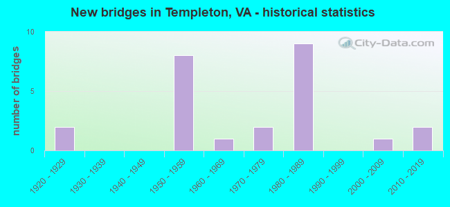
- New bridges - historical statistics
- 21920-1929
- 81950-1959
- 11960-1969
- 21970-1979
- 91980-1989
- 12000-2009
- 22010-2019

- Reconstructed bridges - Historical Statistics
- 12000-2009
- 12010-2019


- Bridge Condition - Deck
- 46.7%Good
- 26.7%Satisfactory
- 20.0%Fair
- 6.7%Poor

- Bridge Condition - Superstructure
- 6.7%Very good
- 26.7%Good
- 53.3%Satisfactory
- 13.3%Fair

- Bridge Condition - Substructure
- 6.7%Good
- 66.7%Satisfactory
- 26.7%Fair

- Bridge Condition - Channel
- 6.7%Good
- 53.3%Satisfactory
- 33.3%Fair
- 6.7%Poor

- Bridge Condition - Culverts
- 20.0%Good
- 80.0%Satisfactory
Find on map >> Show street view
Structure Number: 601, Location: 0.31 Fr PGC & 0.59 To 668 (Lat: 37.068353, Lng: -77.400586), Route carried "on" structure: County highway 604, Year Built: 1985, Status: Open, Structure Length: 5.89m (19.32ft), Average Daily Traffic: 531 (year 2020), Truck Traffic: 12%, Average Future Daily Traffic: 743 (year 2040), Design Load: HS 20+Mod, Features Intersected: CSX TRANSPORTATION, Facility Carried by Structure: HALIFAX ROAD
Minimum Vertical Clearance: 30+ m (98+ ft), Kilometerpoint: 0.505, Lanes on structure: 2, Owner: State Highway Agency, Approaching Roadway Width: 8.2m (26.9ft), Skew: 4 degrees, Material/Design: Steel, Design/Construction: Stringer/Multi-beam, Number Of Spans In Main Unit: 3, Length of Maximum Span: 23.9m (78.4ft), Curb-To-Curb Width: 7.9m (25.9ft), Out-to-Out Width: 8.9m (29.2ft)
Condition: Deck: Good, Superstructure: Fair, Substructure: Satisfactory, Operating Rating: 73.5 metric tons, Method Used To Determine Operating Rating: Load and Resistance Factor (LRFR), Inventory Rating: 56.2 metric tons, Method Used To Determine Inventory Rating: Load and Resistance Factor (LRFR), Structural Evaluation: Somewhat better than minimum adequacy, Deck Geometry: Somewhat better than minimum adequacy, Underclear: Equal to present minimum criteria, Approach Roadway Alignment: Equal to present desirable criteria, Designated Inspection Frequency: Every 24 months, Inspection Date: December 2021, Deck Structure Type: Concrete Cast-file-Place, Wearing Surface/Protective System: Deck Protection: Epoxy Coated Reinforcing
Find on map >> Show street view
Structure Number: 14016, Location: 0.38 Fr DEnd & 0.73 To 35 (Lat: 37.073089, Lng: -77.365542), Route carried "on" structure: ServiceCounty highway F121, Year Built: 1980, Status: Open, Structure Length: 0.92m (3.02ft), Average Daily Traffic: 654 (year 2017), Average Future Daily Traffic: 729 (year 2040), Design Load: HS 20+Mod, Features Intersected: JONES HOLE SWAMP, Facility Carried by Structure: PARKDALE ROAD
Minimum Vertical Clearance: 30+ m (98+ ft), Kilometerpoint: 0.636, Lanes on structure: 2, Owner: State Highway Agency, Approaching Roadway Width: 8.2m (26.9ft), Material/Design: Concrete, Design/Construction: Tee Beam, Number Of Spans In Main Unit: 1, Length of Maximum Span: 8.3m (27.2ft), Curb-To-Curb Width: 8.3m (27.2ft), Out-to-Out Width: 9.3m (30.5ft)
Condition: Deck: Good, Superstructure: Good, Substructure: Satisfactory, Channel: Fair, Operating Rating: 52.6 metric tons, Method Used To Determine Operating Rating: Load and Resistance Factor (LRFR), Inventory Rating: 40.8 metric tons, Method Used To Determine Inventory Rating: Load and Resistance Factor (LRFR), Structural Evaluation: Equal to present minimum criteria, Deck Geometry: Somewhat better than minimum adequacy, Waterway Adequacy: Equal to present desirable criteria, Approach Roadway Alignment: Equal to present desirable criteria, Designated Inspection Frequency: Every 24 months, Underwater Inspection Frequency: Every 48 months, Inspection Date: January 2022, Underwater Inspection Date: January 2022, Deck Structure Type: Concrete Cast-file-Place, Wearing Surface/Protective System: Deck Protection: Epoxy Coated Reinforcing
Find on map >> Show street view
Structure Number: 14017, Location: 0.93 Fr 605 & 0.57 To 696 (Lat: 37.108958, Lng: -77.359750), Route carried "on" structure: ServiceCounty highway F122, Year Built: 1959, Status: Open, Structure Length: 1.40m (4.59ft), Average Daily Traffic: 496 (year 2014), Average Future Daily Traffic: 560 (year 2040), Design Load: HS 20+Mod, Features Intersected: WARWICK SWAMP, Facility Carried by Structure: SUNNYBROOK ROAD
Minimum Vertical Clearance: 30+ m (98+ ft), Kilometerpoint: 3.105, Lanes on structure: 2, Owner: State Highway Agency, Approaching Roadway Width: 8.5m (27.9ft), Material/Design: Prestressed concrete, Design/Construction: Stringer/Multi-beam, Number Of Spans In Main Unit: 1, Length of Maximum Span: 13.4m (44.0ft), Curb or Sidewalk Widths: Left: 0.8m (2.6ft), Right: 0.8m (2.6ft), Curb-To-Curb Width: 7.3m (24.0ft), Out-to-Out Width: 9.0m (29.5ft)
Condition: Deck: Satisfactory, Superstructure: Satisfactory, Substructure: Satisfactory, Channel: Fair, Operating Rating: 51.2 metric tons, Method Used To Determine Operating Rating: Load and Resistance Factor (LRFR), Inventory Rating: 39.5 metric tons, Method Used To Determine Inventory Rating: Load and Resistance Factor (LRFR), Structural Evaluation: Equal to present minimum criteria, Deck Geometry: Meets minimum limits, Waterway Adequacy: Equal to present desirable criteria, Approach Roadway Alignment: Equal to present desirable criteria, Designated Inspection Frequency: Every 24 months, Inspection Date: March 2020, Deck Structure Type: Concrete Cast-file-Place
Find on map >> Show street view
Structure Number: 14033, Location: 0.10 Fr 301 & 0.13 To 156 (Lat: 37.081781, Lng: -77.358578), Route carried "on" structure: State highway 35, Year Built: 1959, Status: Open, Structure Length: 7.47m (24.51ft), Average Daily Traffic: 1,243 (year 2020), Truck Traffic: 3%, Average Future Daily Traffic: 1,367 (year 2040), Design Load: HS 20+Mod, Features Intersected: INTERSTATE-95, Facility Carried by Structure: COURTLAND ROAD
Minimum Vertical Clearance: 30+ m (98+ ft), Kilometerpoint: 77.367, Lanes on structure: 2, Lanes under structure: 5, Base Highway Network: Yes, Owner: State Highway Agency, Approaching Roadway Width: 11.0m (36.1ft), Skew: 1 degrees, Material/Design: Steel continuous, Design/Construction: Stringer/Multi-beam, Number Of Spans In Main Unit: 4, Length of Maximum Span: 22.9m (75.1ft), Curb-To-Curb Width: 9.8m (32.2ft), Out-to-Out Width: 10.8m (35.4ft)
Condition: Deck: Good, Superstructure: Satisfactory, Substructure: Satisfactory, Operating Rating: 48.5 metric tons, Method Used To Determine Operating Rating: Load and Resistance Factor (LRFR), Inventory Rating: 36.7 metric tons, Method Used To Determine Inventory Rating: Load and Resistance Factor (LRFR), Structural Evaluation: Equal to present minimum criteria, Deck Geometry: Somewhat better than minimum adequacy, Underclear: Meets minimum limits, Approach Roadway Alignment: Equal to present desirable criteria, Length Of Structure Improvement: 7.47m (24.51ft), Designated Inspection Frequency: Every 24 months, Inspection Date: March 2021, Bridge Improvement Cost: $200,000, Roadway Improvement Cost: $100,000, Total Project Cost: $340,000, Deck Structure Type: Concrete Cast-file-Place
Find on map >> Show street view
Structure Number: 14038, Location: 5.67 Fr SSX & 6.27 To295E (Lat: 37.073325, Lng: -77.366114), Route carried "on" structure: Interstate 95, Year Built: 1953, Status: Open, Structure Length: 0.90m (2.95ft), Average Daily Traffic: 14,872 (year 2020), Truck Traffic: 14%, Average Future Daily Traffic: 20,821 (year 2040), Design Load: HS 20, Features Intersected: JONES HOLE SWAMP
Minimum Vertical Clearance: 30+ m (98+ ft), Kilometerpoint: 64.971, Lanes on structure: 2, Base Highway Network: Yes, Owner: State Highway Agency, Approaching Roadway Width: 13.4m (44.0ft), Material/Design: Concrete, Design/Construction: Tee Beam, Number Of Spans In Main Unit: 1, Length of Maximum Span: 8.1m (26.6ft), Curb-To-Curb Width: 13.6m (44.6ft), Out-to-Out Width: 15.3m (50.2ft)
Condition: Deck: Fair, Superstructure: Satisfactory, Substructure: Fair, Channel: Satisfactory, Operating Rating: 53.5 metric tons, Method Used To Determine Operating Rating: Load Factor (LF), Inventory Rating: 31.8 metric tons, Method Used To Determine Inventory Rating: Load Factor (LF), Structural Evaluation: Somewhat better than minimum adequacy, Deck Geometry: Superior to present desirable criteria, Waterway Adequacy: Equal to present desirable criteria, Approach Roadway Alignment: Equal to present desirable criteria, Designated Inspection Frequency: Every 24 months, Underwater Inspection Frequency: Every 48 months, Inspection Date: November 2021, Underwater Inspection Date: November 2021, Deck Structure Type: Concrete Cast-file-Place, Wearing Surface/Protective System: Wearing Surface: Bituminous, Membrane: Preformed Fabric
Find on map >> Show street view
Structure Number: 1404, Location: 1.92 Fr 35 & 2.29 To 301 (Lat: 37.108969, Lng: -77.359278), Route carried "on" structure: Interstate 95, Year Built: 1959, Status: Open, Structure Length: 1.40m (4.59ft), Average Daily Traffic: 21,440 (year 2020), Truck Traffic: 14%, Average Future Daily Traffic: 30,016 (year 2040), Design Load: HS 20+Mod, Features Intersected: WARWICK SWAMP
Minimum Vertical Clearance: 30+ m (98+ ft), Kilometerpoint: 69.219, Lanes on structure: 2, Base Highway Network: Yes, Owner: State Highway Agency, Approaching Roadway Width: 11.0m (36.1ft), Material/Design: Prestressed concrete, Design/Construction: Stringer/Multi-beam, Number Of Spans In Main Unit: 1, Length of Maximum Span: 12.8m (42.0ft), Curb-To-Curb Width: 12.8m (42.0ft), Out-to-Out Width: 13.6m (44.6ft)
Condition: Deck: Fair, Superstructure: Satisfactory, Substructure: Satisfactory, Channel: Satisfactory, Operating Rating: 75.2 metric tons, Method Used To Determine Operating Rating: Load and Resistance Factor (LRFR), Inventory Rating: 54.9 metric tons, Method Used To Determine Inventory Rating: Load and Resistance Factor (LRFR), Structural Evaluation: Equal to present minimum criteria, Deck Geometry: Equal to present desirable criteria, Waterway Adequacy: Equal to present desirable criteria, Approach Roadway Alignment: Equal to present desirable criteria, Designated Inspection Frequency: Every 24 months, Inspection Date: March 2020, Deck Structure Type: Concrete Cast-file-Place, Wearing Surface/Protective System: Wearing Surface: Bituminous, Membrane: Preformed Fabric
Find on map >> Show street view
Structure Number: 14041, Location: 1.91 Fr 35 & 2.30 To 301 (Lat: 37.108967, Lng: -77.359472), Route carried "on" structure: Interstate 95, Year Built: 1959, Status: Open, Structure Length: 1.40m (4.59ft), Average Daily Traffic: 21,469 (year 2020), Truck Traffic: 14%, Average Future Daily Traffic: 30,057 (year 2040), Design Load: HS 20+Mod, Features Intersected: WARWICK SWAMP
Minimum Vertical Clearance: 30+ m (98+ ft), Kilometerpoint: 69.219, Lanes on structure: 2, Base Highway Network: Yes, Owner: State Highway Agency, Approaching Roadway Width: 11.0m (36.1ft), Material/Design: Prestressed concrete, Design/Construction: Stringer/Multi-beam, Number Of Spans In Main Unit: 1, Length of Maximum Span: 12.8m (42.0ft), Curb-To-Curb Width: 12.8m (42.0ft), Out-to-Out Width: 13.6m (44.6ft)
Condition: Deck: Fair, Superstructure: Satisfactory, Substructure: Satisfactory, Channel: Satisfactory, Operating Rating: 75.2 metric tons, Method Used To Determine Operating Rating: Load and Resistance Factor (LRFR), Inventory Rating: 54.9 metric tons, Method Used To Determine Inventory Rating: Load and Resistance Factor (LRFR), Structural Evaluation: Equal to present minimum criteria, Deck Geometry: Equal to present desirable criteria, Waterway Adequacy: Equal to present desirable criteria, Approach Roadway Alignment: Equal to present desirable criteria, Designated Inspection Frequency: Every 24 months, Inspection Date: March 2020, Deck Structure Type: Concrete Cast-file-Place, Wearing Surface/Protective System: Wearing Surface: Bituminous, Membrane: Preformed Fabric
Find on map >> Show street view
Structure Number: 14046, Location: 2.02 fr 623& 1.70 to 35 (Lat: 37.060883, Lng: -77.374458), Route carried "on" structure: Interstate 95, Year Built: 1980, Status: Open, Structure Length: 0.73m (2.40ft), Average Daily Traffic: 32,445 (year 2020), Truck Traffic: 14%, Average Future Daily Traffic: 45,423 (year 2040), Design Load: HS 20+Mod, Features Intersected: BABBIT'S BRANCH
Minimum Vertical Clearance: 30+ m (98+ ft), Kilometerpoint: 63.234, Lanes on structure: 6, Base Highway Network: Yes, Owner: State Highway Agency, Approaching Roadway Width: 30.5m (100.1ft), Skew: 24 degrees, Material/Design: Concrete, Design/Construction: Culvert, Number Of Spans In Main Unit: 3, Length of Maximum Span: 2.2m (7.2ft)
Condition: Channel: Fair, Culverts: Satisfactory, Operating Rating: 54.4 metric tons, Method Used To Determine Operating Rating: Field evaluation and documented engineering judgment, Inventory Rating: 32.7 metric tons, Method Used To Determine Inventory Rating: Field evaluation and documented engineering judgment, Structural Evaluation: Equal to present minimum criteria, Waterway Adequacy: Equal to present desirable criteria, Approach Roadway Alignment: Equal to present desirable criteria, Designated Inspection Frequency: Every 24 months, Inspection Date: Febuary 2021
Find on map >> Show street view
Structure Number: 1405, Location: 5.64 Fr SSX & 4.90 To 301 (Lat: 37.073203, Lng: -77.365850), Route carried "on" structure: Interstate 95, Year Built: 1980, Status: Open, Structure Length: 0.92m (3.02ft), Average Daily Traffic: 17,573 (year 2020), Truck Traffic: 14%, Average Future Daily Traffic: 24,602 (year 2040), Design Load: HS 20+Mod, Features Intersected: JONES HOLE SWAMP
Minimum Vertical Clearance: 30+ m (98+ ft), Kilometerpoint: 64.971, Lanes on structure: 2, Base Highway Network: Yes, Owner: State Highway Agency, Approaching Roadway Width: 12.2m (40.0ft), Material/Design: Concrete, Design/Construction: Tee Beam, Number Of Spans In Main Unit: 1, Length of Maximum Span: 8.3m (27.2ft), Curb-To-Curb Width: 12.4m (40.7ft), Out-to-Out Width: 13.4m (44.0ft)
Condition: Deck: Satisfactory, Superstructure: Good, Substructure: Fair, Channel: Poor, Operating Rating: 55.3 metric tons, Method Used To Determine Operating Rating: Load and Resistance Factor (LRFR), Inventory Rating: 42.6 metric tons, Method Used To Determine Inventory Rating: Load and Resistance Factor (LRFR), Structural Evaluation: Somewhat better than minimum adequacy, Deck Geometry: Better than present minimum criteria, Waterway Adequacy: Equal to present desirable criteria, Approach Roadway Alignment: Equal to present desirable criteria, Length Of Structure Improvement: 0.85m (2.79ft), Designated Inspection Frequency: Every 24 months, Underwater Inspection Frequency: Every 24 months, Inspection Date: January 2022, Underwater Inspection Date: January 2022, Bridge Improvement Cost: $200,000, Roadway Improvement Cost: $10,000, Total Project Cost: $230,000, Deck Structure Type: Concrete Cast-file-Place, Wearing Surface/Protective System: Deck Protection: Epoxy Coated Reinforcing
Find on map >> Show street view
Structure Number: 14066, Location: 0.62 Fr 638 & 1.26 To 626 (Lat: 37.110283, Lng: -77.324628), Route carried "on" structure: State highway 156, Year Built: 1969, Status: Open, Structure Length: 0.98m (3.22ft), Average Daily Traffic: 1,855 (year 2020), Truck Traffic: 8%, Average Future Daily Traffic: 2,040 (year 2040), Design Load: HS 20, Features Intersected: LEE'S MILL POND, Facility Carried by Structure: PRINCE GEORGE DR
Minimum Vertical Clearance: 30+ m (98+ ft), Kilometerpoint: 4.594, Lanes on structure: 2, Owner: State Highway Agency, Approaching Roadway Width: 9.1m (29.9ft), Material/Design: Concrete, Design/Construction: Culvert, Number Of Spans In Main Unit: 3, Length of Maximum Span: 3.0m (9.8ft)
Condition: Channel: Satisfactory, Culverts: Satisfactory, Operating Rating: 54.4 metric tons, Method Used To Determine Operating Rating: Field evaluation and documented engineering judgment, Inventory Rating: 32.7 metric tons, Method Used To Determine Inventory Rating: Field evaluation and documented engineering judgment, Structural Evaluation: Equal to present minimum criteria, Waterway Adequacy: Equal to present minimum criteria, Approach Roadway Alignment: Equal to present desirable criteria, Designated Inspection Frequency: Every 24 months, Underwater Inspection Frequency: Every 24 months, Inspection Date: January 2022, Underwater Inspection Date: January 2022
Find on map >> Show street view
Structure Number: 14072, Location: 0.57 Fr 711 & 1.56 To 608 (Lat: 37.106131, Lng: -77.354467), Route carried "on" structure: US 301, Year Built: 1927, Year Reconstructed: 2008, Status: Open, Structure Length: 0.98m (3.22ft), Average Daily Traffic: 2,130 (year 2020), Truck Traffic: 4%, Average Future Daily Traffic: 2,343 (year 2040), Design Load: HS 20+Mod, Features Intersected: WARWICK SWAMP, Facility Carried by Structure: SOUTH CRATER ROAD
Minimum Vertical Clearance: 30+ m (98+ ft), Kilometerpoint: 69.525, Lanes on structure: 2, Owner: State Highway Agency, Approaching Roadway Width: 10.4m (34.1ft), Material/Design: Prestressed concrete, Design/Construction: Box Beam or Girders - Multiple, Number Of Spans In Main Unit: 1, Length of Maximum Span: 9.5m (31.2ft), Curb-To-Curb Width: 10.2m (33.5ft), Out-to-Out Width: 11.0m (36.1ft)
Condition: Deck: Good, Superstructure: Good, Substructure: Satisfactory, Channel: Satisfactory, Operating Rating: 38.5 metric tons, Method Used To Determine Operating Rating: Load and Resistance Factor (LRFR), Inventory Rating: 29.7 metric tons, Method Used To Determine Inventory Rating: Load and Resistance Factor (LRFR), Structural Evaluation: Equal to present minimum criteria, Deck Geometry: Meets minimum limits, Waterway Adequacy: Equal to present minimum criteria, Approach Roadway Alignment: Equal to present desirable criteria, Designated Inspection Frequency: Every 24 months, Underwater Inspection Frequency: Every 60 months, Inspection Date: January 2021, Underwater Inspection Date: January 2021, Deck Structure Type: Concrete Cast-file-Place, Wearing Surface/Protective System: Wearing Surface: Bituminous, Membrane: Epoxy, Deck Protection: Epoxy Coated Reinforcing
Find on map >> Show street view
Structure Number: 14073, Location: 1.52 Fr 675 & 1.24 To 156 (Lat: 37.073419, Lng: -77.366333), Route carried "on" structure: US 301, Year Built: 1929, Status: Open, Structure Length: 0.84m (2.76ft), Average Daily Traffic: 1,664 (year 2020), Truck Traffic: 12%, Average Future Daily Traffic: 1,830 (year 2040), Design Load: HS 20+Mod, Features Intersected: JONES HOLE SWAMP, Facility Carried by Structure: SUNNYBROOK ROAD
Minimum Vertical Clearance: 30+ m (98+ ft), Kilometerpoint: 64.827, Lanes on structure: 2, Owner: State Highway Agency, Approaching Roadway Width: 8.5m (27.9ft), Material/Design: Concrete, Design/Construction: Tee Beam, Number Of Spans In Main Unit: 1, Length of Maximum Span: 8.2m (26.9ft), Curb or Sidewalk Widths: Left: 0.5m (1.6ft), Right: 0.5m (1.6ft), Curb-To-Curb Width: 8.5m (27.9ft), Out-to-Out Width: 9.0m (29.5ft)
Condition: Deck: Satisfactory, Superstructure: Satisfactory, Substructure: Satisfactory, Channel: Satisfactory, Operating Rating: 48.1 metric tons, Method Used To Determine Operating Rating: Load and Resistance Factor (LRFR), Inventory Rating: 37.2 metric tons, Method Used To Determine Inventory Rating: Load and Resistance Factor (LRFR), Structural Evaluation: Equal to present minimum criteria, Deck Geometry: Somewhat better than minimum adequacy, Waterway Adequacy: Equal to present minimum criteria, Approach Roadway Alignment: Equal to present desirable criteria, Designated Inspection Frequency: Every 24 months, Underwater Inspection Frequency: Every 48 months, Inspection Date: November 2021, Underwater Inspection Date: November 2021, Deck Structure Type: Concrete Cast-file-Place, Wearing Surface/Protective System: Wearing Surface: Bituminous
Find on map >> Show street view
Structure Number: 14086, Location: 0.05 Fr 607 & 0.96 To 628 (Lat: 37.126847, Lng: -77.361342), Route carried "on" structure: County highway 608, Year Built: 1972, Status: Open, Structure Length: 0.70m (2.30ft), Average Daily Traffic: 759 (year 2020), Average Future Daily Traffic: 848 (year 2040), Design Load: HS 20, Features Intersected: BRANCH OF WARWICK SWAMP, Facility Carried by Structure: COLLEGE ROAD
Minimum Vertical Clearance: 30+ m (98+ ft), Kilometerpoint: 0.853, Lanes on structure: 2, Owner: State Highway Agency, Approaching Roadway Width: 7.3m (24.0ft), Material/Design: Concrete, Design/Construction: Culvert, Number Of Spans In Main Unit: 2, Length of Maximum Span: 3.0m (9.8ft)
Condition: Channel: Fair, Culverts: Satisfactory, Inventory Rating: 79.5 metric tons, Method Used To Determine Inventory Rating: Load and Resistance Factor (LRFR), Structural Evaluation: Equal to present minimum criteria, Waterway Adequacy: Equal to present minimum criteria, Approach Roadway Alignment: Equal to present minimum criteria, Designated Inspection Frequency: Every 24 months, Underwater Inspection Frequency: Every 48 months, Inspection Date: October 2020, Underwater Inspection Date: August 2018
Find on map >> Show street view
Structure Number: 14087, Location: 0.29 Fr 301 & 0.24 To 607 (Lat: 37.126728, Lng: -77.357919), Route carried "on" structure: County highway 608, Year Built: 1959, Status: Open, Structure Length: 6.78m (22.24ft), Average Daily Traffic: 759 (year 2020), Truck Traffic: 3%, Average Future Daily Traffic: 848 (year 2040), Design Load: H 20, Features Intersected: INTERSTATE-95, Facility Carried by Structure: GARY'S CHURCH ROAD
Minimum Vertical Clearance: 30+ m (98+ ft), Kilometerpoint: 0.467, Lanes on structure: 2, Lanes under structure: 4, Owner: State Highway Agency, Approaching Roadway Width: 9.8m (32.2ft), Skew: 1 degrees, Material/Design: Steel continuous, Design/Construction: Stringer/Multi-beam, Number Of Spans In Main Unit: 4, Length of Maximum Span: 18.4m (60.4ft), Curb or Sidewalk Widths: Left: 0.5m (1.6ft), Right: 0.5m (1.6ft), Curb-To-Curb Width: 7.3m (24.0ft), Out-to-Out Width: 9.0m (29.5ft)
Condition: Deck: Poor, Superstructure: Fair, Substructure: Fair, Operating Rating: 40.1 metric tons, Method Used To Determine Operating Rating: Load and Resistance Factor (LRFR), Inventory Rating: 30.9 metric tons, Method Used To Determine Inventory Rating: Load and Resistance Factor (LRFR), Structural Evaluation: Somewhat better than minimum adequacy, Deck Geometry: Meets minimum limits, Underclear: Meets minimum limits, Approach Roadway Alignment: Equal to present desirable criteria, Length Of Structure Improvement: 13.72m (45.01ft), Designated Inspection Frequency: Every 12 months, Inspection Date: August 2021, Bridge Improvement Cost: $500,000, Roadway Improvement Cost: $10,000, Total Project Cost: $600,000 ( Estimate for 2014), Deck Structure Type: Concrete Cast-file-Place
Find on map >> Show street view
Structure Number: 14101, Location: 0.40 Fr 670 & 0.15 To 301 (Lat: 37.034528, Lng: -77.389717), Route carried "on" structure: County highway 623, Year Built: 1980, Status: Open, Structure Length: 7.52m (24.67ft), Average Daily Traffic: 1,135 (year 2020), Truck Traffic: 2%, Average Future Daily Traffic: 1,157 (year 2040), Design Load: HS 20+Mod, Features Intersected: INTERSTATE-95, Facility Carried by Structure: ROWANTY ROAD
Minimum Vertical Clearance: 30+ m (98+ ft), Kilometerpoint: 5.027, Lanes on structure: 2, Lanes under structure: 4, Owner: State Highway Agency, Approaching Roadway Width: 12.2m (40.0ft), Skew: 1 degrees, Material/Design: Steel continuous, Design/Construction: Stringer/Multi-beam, Number Of Spans In Main Unit: 2, Length of Maximum Span: 37.0m (121.4ft), Curb-To-Curb Width: 12.3m (40.4ft), Out-to-Out Width: 13.4m (44.0ft)
Condition: Deck: Good, Superstructure: Satisfactory, Substructure: Fair, Operating Rating: 70.6 metric tons, Method Used To Determine Operating Rating: Load and Resistance Factor (LRFR), Inventory Rating: 54.4 metric tons, Method Used To Determine Inventory Rating: Load and Resistance Factor (LRFR), Structural Evaluation: Somewhat better than minimum adequacy, Deck Geometry: Better than present minimum criteria, Underclear: Equal to present minimum criteria, Approach Roadway Alignment: Equal to present desirable criteria, Designated Inspection Frequency: Every 24 months, Inspection Date: April 2021, Deck Structure Type: Concrete Cast-file-Place, Wearing Surface/Protective System: Deck Protection: Epoxy Coated Reinforcing
Find on map >> Show street view
Structure Number: 14116, Location: 0.15 Fr 675 & 0.20 To 671 (Lat: 37.054956, Lng: -77.379656), Route carried "on" structure: County highway 631, Year Built: 1980, Status: Open, Structure Length: 9.35m (30.68ft), Average Daily Traffic: 473 (year 2014), Average Future Daily Traffic: 719 (year 2040), Design Load: HS 20+Mod, Features Intersected: INTERSTATE-95 & RTE 301, Facility Carried by Structure: LANSING ROAD
Minimum Vertical Clearance: 30+ m (98+ ft), Kilometerpoint: 0.949, Lanes on structure: 2, Lanes under structure: 6, Owner: State Highway Agency, Approaching Roadway Width: 9.1m (29.9ft), Skew: 2 degrees, Material/Design: Steel, Design/Construction: Stringer/Multi-beam, Number Of Spans In Main Unit: 3, Length of Maximum Span: 36.9m (121.1ft), Curb-To-Curb Width: 8.3m (27.2ft), Out-to-Out Width: 9.3m (30.5ft)
Condition: Deck: Satisfactory, Superstructure: Satisfactory, Substructure: Satisfactory, Operating Rating: 63.0 metric tons, Method Used To Determine Operating Rating: Load and Resistance Factor (LRFR), Inventory Rating: 48.6 metric tons, Method Used To Determine Inventory Rating: Load and Resistance Factor (LRFR), Structural Evaluation: Equal to present minimum criteria, Deck Geometry: Somewhat better than minimum adequacy, Underclear: Better than present minimum criteria, Approach Roadway Alignment: Equal to present desirable criteria, Designated Inspection Frequency: Every 24 months, Inspection Date: April 2021, Deck Structure Type: Concrete Cast-file-Place, Wearing Surface/Protective System: Deck Protection: Epoxy Coated Reinforcing
Find on map >> Show street view
Structure Number: 14131, Location: 1.40 Fr 623 & 2.10 To 638 (Lat: 37.017025, Lng: -77.354603), Route carried "on" structure: County highway 650, Year Built: 2012, Status: Open, Structure Length: 0.94m (3.08ft), Average Daily Traffic: 133 (year 2017), Average Future Daily Traffic: 149 (year 2040), Design Load: H 20, Features Intersected: INDIAN CREEK, Facility Carried by Structure: HORSE SHOE ROAD
Minimum Vertical Clearance: 30+ m (98+ ft), Kilometerpoint: 2.253, Lanes on structure: 2, Owner: State Highway Agency, Approaching Roadway Width: 6.7m (22.0ft), Material/Design: Steel, Design/Construction: Culvert, Number Of Spans In Main Unit: 3, Length of Maximum Span: 2.4m (7.9ft)
Condition: Channel: Fair, Culverts: Good, Operating Rating: 44.5 metric tons, Method Used To Determine Operating Rating: Field evaluation and documented engineering judgment, Inventory Rating: 32.7 metric tons, Method Used To Determine Inventory Rating: Field evaluation and documented engineering judgment, Structural Evaluation: Better than present minimum criteria, Waterway Adequacy: Equal to present minimum criteria, Approach Roadway Alignment: Equal to present minimum criteria, Length Of Structure Improvement: 0.70m (2.30ft), Designated Inspection Frequency: Every 24 months, Inspection Date: December 2020, Bridge Improvement Cost: $50,000, Roadway Improvement Cost: $1,000, Total Project Cost: $56,000
Find on map >> Show street view
Structure Number: 18358, Location: 1.75fr602/.30to Pr George (Lat: 37.029886, Lng: -77.314467), Route carried "on" structure: County highway 637, Year Built: 1974, Year Reconstructed: 2016, Status: Open, Structure Length: 2.66m (8.73ft), Average Daily Traffic: 72 (year 2014), Average Future Daily Traffic: 81 (year 2040), Design Load: HS 20+Mod, Features Intersected: Jones Hole Swamp, Facility Carried by Structure: Railroad Bed Road
Minimum Vertical Clearance: 30+ m (98+ ft), Kilometerpoint: 15.350, Lanes on structure: 2, Owner: State Highway Agency, Approaching Roadway Width: 5.5m (18.0ft), Material/Design: Steel, Design/Construction: Stringer/Multi-beam, Number Of Spans In Main Unit: 2, Length of Maximum Span: 13.0m (42.7ft), Curb-To-Curb Width: 7.1m (23.3ft), Out-to-Out Width: 7.7m (25.3ft)
Condition: Deck: Good, Superstructure: Very good, Substructure: Good, Channel: Good, Operating Rating: 73.5 metric tons, Method Used To Determine Operating Rating: Load and Resistance Factor (LRFR), Inventory Rating: 57.2 metric tons, Method Used To Determine Inventory Rating: Load and Resistance Factor (LRFR), Structural Evaluation: Better than present minimum criteria, Deck Geometry: Somewhat better than minimum adequacy, Waterway Adequacy: Better than present minimum criteria, Approach Roadway Alignment: Equal to present desirable criteria, Designated Inspection Frequency: Every 24 months, Underwater Inspection Frequency: Every 60 months, Inspection Date: March 2022, Underwater Inspection Date: March 2020, Deck Structure Type: Wood or Timber, Wearing Surface/Protective System: Wearing Surface: Gravel
Find on map >> Show street view
Structure Number: 26115, Location: 0.55 Fr 607 & 0.2 To 1130 (Lat: 37.116031, Lng: -77.389778), Route carried "on" structure: County highway 622, Year Built: 2000, Status: Open, Structure Length: 1.22m (4.00ft), Average Daily Traffic: 549 (year 2017), Average Future Daily Traffic: 737 (year 2040), Design Load: HS 20+Mod, Features Intersected: WARWICK SWAMP, Facility Carried by Structure: FAIRWOOD ROAD
Minimum Vertical Clearance: 30+ m (98+ ft), Kilometerpoint: 3.942, Lanes on structure: 2, Owner: State Highway Agency, Approaching Roadway Width: 6.4m (21.0ft), Material/Design: Prestressed concrete, Design/Construction: Slab, Number Of Spans In Main Unit: 1, Length of Maximum Span: 11.6m (38.1ft), Curb or Sidewalk Widths: Left: 0.2m (0.7ft), Right: 0.2m (0.7ft), Curb-To-Curb Width: 6.6m (21.7ft), Out-to-Out Width: 7.6m (24.9ft)
Condition: Deck: Good, Superstructure: Good, Substructure: Satisfactory, Channel: Satisfactory, Operating Rating: 57.3 metric tons, Method Used To Determine Operating Rating: Load and Resistance Factor (LRFR), Inventory Rating: 44.2 metric tons, Method Used To Determine Inventory Rating: Load and Resistance Factor (LRFR), Structural Evaluation: Equal to present minimum criteria, Deck Geometry: High priority of corrective action, Waterway Adequacy: Equal to present minimum criteria, Approach Roadway Alignment: Meets minimum limits, Designated Inspection Frequency: Every 24 months, Inspection Date: October 2020, Deck Structure Type: Other, Wearing Surface/Protective System: Wearing Surface: Bituminous, Membrane: Epoxy, Deck Protection: Epoxy Coated Reinforcing
Find on map >> Show street view
Structure Number: 29132, Location: 1.77 Fr 604 & 0.51 To 605 (Lat: 37.079483, Lng: -77.371850), Route carried "on" structure: County highway 621, Year Built: 2010, Status: Open, Structure Length: 1.40m (4.59ft), Average Daily Traffic: 184 (year 2017), Average Future Daily Traffic: 224 (year 2040), Design Load: H 20, Features Intersected: JONES HOLE SWAMP, Facility Carried by Structure: SHANDS ROAD
Minimum Vertical Clearance: 30+ m (98+ ft), Kilometerpoint: 2.853, Lanes on structure: 2, Owner: State Highway Agency, Approaching Roadway Width: 5.8m (19.0ft), Material/Design: Steel, Design/Construction: Culvert, Number Of Spans In Main Unit: 6, Length of Maximum Span: 1.8m (5.9ft)
Condition: Channel: Satisfactory, Culverts: Satisfactory, Operating Rating: 44.5 metric tons, Method Used To Determine Operating Rating: Field evaluation and documented engineering judgment, Inventory Rating: 32.7 metric tons, Method Used To Determine Inventory Rating: Field evaluation and documented engineering judgment, Structural Evaluation: Equal to present minimum criteria, Waterway Adequacy: Equal to present desirable criteria, Approach Roadway Alignment: Equal to present desirable criteria, Designated Inspection Frequency: Every 24 months, Inspection Date: September 2020
Find on map >> Show street view
Structure Number: 14033, Location: 0.10 Fr 301 & 0.13 To 156 (Lat: 37.081781, Lng: -77.358578), Route carried "under" structure: Interstate 95, Year Built: 1959, Structure Length: 0. m, Average Daily Traffic: 40,000 (year 2019), Truck Traffic: 14%, Features Intersected: INTERSTATE-95, Facility Carried by Structure: COURTLAND ROAD
Minimum Vertical Clearance: 4.90m (16.08ft), Kilometerpoint: 66.130, Lanes on structure: 2, Lanes under structure: 5, Material/Design: Steel continuous, Design/Construction: Stringer/Multi-beam, Length of Maximum Span: 22.9m (75.1ft)
Find on map >> Show street view
Structure Number: 14087, Location: 0.29 Fr 301 & 0.24 To 607 (Lat: 37.126728, Lng: -77.357919), Route carried "under" structure: Interstate 95, Year Built: 1959, Structure Length: 0. m, Average Daily Traffic: 43,000 (year 2020), Truck Traffic: 18%, Features Intersected: INTERSTATE-95, Facility Carried by Structure: GARY'S CHURCH ROAD
Minimum Vertical Clearance: 5.00m (16.40ft), Kilometerpoint: 71.134, Lanes on structure: 2, Lanes under structure: 4, Material/Design: Steel continuous, Design/Construction: Stringer/Multi-beam, Length of Maximum Span: 18.4m (60.4ft)
Find on map >> Show street view
Structure Number: 14101, Location: 0.40 Fr 670 & 0.15 To 301 (Lat: 37.034528, Lng: -77.389717), Route carried "under" structure: Interstate 95, Year Built: 1980, Structure Length: 0. m, Average Daily Traffic: 39,000 (year 2018), Truck Traffic: 14%, Features Intersected: INTERSTATE-95, Facility Carried by Structure: ROWANTY ROAD
Minimum Vertical Clearance: 5.28m (17.32ft), Kilometerpoint: 60.144, Lanes on structure: 2, Lanes under structure: 4, Material/Design: Steel continuous, Design/Construction: Stringer/Multi-beam, Length of Maximum Span: 37.0m (121.4ft)
Find on map >> Show street view
Structure Number: 14116, Location: 0.15 Fr 675 & 0.20 To 671 (Lat: 37.054956, Lng: -77.379656), Route carried "under" structure: Interstate 95, Year Built: 1980, Structure Length: 0. m, Average Daily Traffic: 40,000 (year 2018), Truck Traffic: 14%, Features Intersected: INTERSTATE-95 & RTE 301, Facility Carried by Structure: LANSING ROAD
Minimum Vertical Clearance: 5.39m (17.68ft), Kilometerpoint: 62.622, Lanes on structure: 2, Lanes under structure: 4, Material/Design: Steel, Design/Construction: Stringer/Multi-beam, Length of Maximum Span: 36.9m (121.1ft)
Find on map >> Show street view
Structure Number: 14116, Location: 0.15 Fr 675 & 0.20 To 671 (Lat: 37.054956, Lng: -77.379656), Route carried "under" structure: US 301, Year Built: 1980, Structure Length: 0. m, Average Daily Traffic: 1,400 (year 2018), Truck Traffic: 13%, Features Intersected: INTERSTATE-95 & RTE 301, Facility Carried by Structure: LANSING ROAD
Minimum Vertical Clearance: 5.16m (16.93ft), Kilometerpoint: 62.623, Lanes on structure: 2, Lanes under structure: 2, Material/Design: Steel, Design/Construction: Stringer/Multi-beam, Length of Maximum Span: 36.9m (121.1ft)