Bridge Statistics for Tannersville, New York (NY)
Condition, Traffic, Stress, Structural Evaluation, Project Costs
- National Bridge Inventory (NBI) Statistics
- 16Number of bridges
- 69ft / 20.9mTotal length
- $11,191,000Total costs
- 14,064Total average daily traffic
- 938Total average daily truck traffic
- 15,569Total future (year 2036) average daily traffic
- National Bridge Inventory (NBI) Registered Bridges for Tannersville
- No street view available for this location
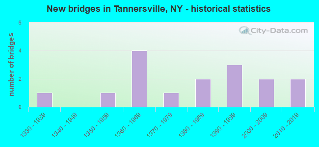
- New bridges - historical statistics
- 11930-1939
- 11950-1959
- 41960-1969
- 11970-1979
- 21980-1989
- 31990-1999
- 22000-2009
- 22010-2019

- Reconstructed bridges - Historical Statistics
- 21980-1989
- 21990-1999


- Bridge Condition - Deck
- 7.1%Excellent
- 14.3%Very good
- 35.7%Good
- 21.4%Satisfactory
- 21.4%Fair

- Bridge Condition - Superstructure
- 14.3%Excellent
- 14.3%Very good
- 28.6%Good
- 14.3%Satisfactory
- 14.3%Fair
- 14.3%Poor

- Bridge Condition - Substructure
- 7.1%Excellent
- 28.6%Very good
- 14.3%Good
- 14.3%Satisfactory
- 21.4%Fair
- 7.1%Poor
- 7.1%Critical

- Bridge Condition - Channel
- 31.3%Good
- 37.5%Satisfactory
- 31.3%Fair

- Bridge Condition - Culverts
- 50.0%Good
- 50.0%Satisfactory
Find on map >> Show street view
Structure Number: 101795, Location: 1.8 MI E JCT RT 23A & 214 (Lat: 42.196003, Lng: -74.146231), Route carried "on" structure: State highway 23A, Year Built: 1994, Status: Open, Structure Length: 1.13m (3.71ft), Average Daily Traffic: 3,747 (year 2017), Truck Traffic: 6%, Average Future Daily Traffic: 3,908 (year 2040), Design Load: HS 20, Features Intersected: ALLEN BROOK
Minimum Vertical Clearance: 30+ m (98+ ft), Kilometerpoint: 30.137, Lanes on structure: 2, Base Highway Network: Yes, Owner: State Highway Agency, Approaching Roadway Width: 10.4m (34.1ft), Skew: 1 degrees, Material/Design: Concrete, Design/Construction: Culvert, Number Of Spans In Main Unit: 1, Length of Maximum Span: 11.0m (36.1ft), Curb or Sidewalk Widths: Left: 1.5m (4.9ft), Right: 0.0m, Curb-To-Curb Width: 10.4m (34.1ft), Out-to-Out Width: 12.6m (41.3ft)
Condition: Channel: Fair, Culverts: Good, Operating Rating: 69.9 metric tons, Method Used To Determine Operating Rating: Load Factor (LF), Inventory Rating: 41.7 metric tons, Method Used To Determine Inventory Rating: Load Factor (LF), Structural Evaluation: Better than present minimum criteria, Deck Geometry: Somewhat better than minimum adequacy, Waterway Adequacy: Meets minimum limits, Approach Roadway Alignment: Equal to present desirable criteria, Length Of Structure Improvement: 1.12m (3.67ft), Designated Inspection Frequency: Every 24 months, Inspection Date: May 2020, Bridge Improvement Cost: $528,000, Roadway Improvement Cost: $309,000, Total Project Cost: $837,000 ( Estimate for 2021), Wearing Surface/Protective System: Wearing Surface: Bituminous, Membrane: Other
Find on map >> Show street view
Structure Number: 101796, Location: 2.4 MI E JCT RT 23A & 214 (Lat: 42.195694, Lng: -74.134369), Route carried "on" structure: State highway 23A, Year Built: 1953, Status: Open, Structure Length: 0.79m (2.59ft), Average Daily Traffic: 3,747 (year 2017), Truck Traffic: 6%, Average Future Daily Traffic: 3,908 (year 2040), Design Load: H 20, Features Intersected: SAWMILL CREEK
Minimum Vertical Clearance: 30+ m (98+ ft), Kilometerpoint: 31.134, Lanes on structure: 2, Base Highway Network: Yes, Owner: State Highway Agency, Approaching Roadway Width: 10.1m (33.1ft), Skew: 1 degrees, Material/Design: Concrete, Design/Construction: Slab, Number Of Spans In Main Unit: 1, Length of Maximum Span: 7.3m (24.0ft), Curb or Sidewalk Widths: Left: 1.7m (5.6ft), Right: 1.7m (5.6ft), Curb-To-Curb Width: 10.1m (33.1ft), Out-to-Out Width: 13.7m (44.9ft)
Condition: Deck: Good, Superstructure: Good, Substructure: Good, Channel: Good, Operating Rating: 79.8 metric tons, Method Used To Determine Operating Rating: Load Factor (LF), Inventory Rating: 47.2 metric tons, Method Used To Determine Inventory Rating: Load Factor (LF), Structural Evaluation: Better than present minimum criteria, Deck Geometry: Meets minimum limits, Waterway Adequacy: Somewhat better than minimum adequacy, Approach Roadway Alignment: Equal to present desirable criteria, Length Of Structure Improvement: 1.00m (3.28ft), Designated Inspection Frequency: Every 24 months, Inspection Date: May 2021, Bridge Improvement Cost: $873,000, Roadway Improvement Cost: $511,000, Total Project Cost: $1,384,000 ( Estimate for 2021)
Find on map >> Show street view
Structure Number: 101797, Location: RT 23A IN HAINES FALLS (Lat: 42.195744, Lng: -74.096800), Route carried "on" structure: State highway 23A, Year Built: 1961, Status: Open, Structure Length: 1.22m (4.00ft), Average Daily Traffic: 4,049 (year 2019), Truck Traffic: 9%, Average Future Daily Traffic: 4,223 (year 2040), Features Intersected: KAATERSKILL CREEK
Minimum Vertical Clearance: 30+ m (98+ ft), Kilometerpoint: 34.336, Lanes on structure: 2, Base Highway Network: Yes, Owner: State Highway Agency, Approaching Roadway Width: 9.8m (32.2ft), Material/Design: Concrete, Design/Construction: Culvert, Number Of Spans In Main Unit: 3, Length of Maximum Span: 3.6m (11.8ft)
Condition: Channel: Good, Culverts: Satisfactory, Operating Rating: 97.2 metric tons, Method Used To Determine Operating Rating: Load and Resistance Factor Rating (LRFR) rating reported by rating factor(RF) method using HL-93 loadings, Inventory Rating: 97.2 metric tons, Method Used To Determine Inventory Rating: Load and Resistance Factor Rating (LRFR) rating reported by rating factor(RF) method using HL-93 loadings, Structural Evaluation: Equal to present minimum criteria, Waterway Adequacy: Somewhat better than minimum adequacy, Approach Roadway Alignment: Equal to present desirable criteria, Length Of Structure Improvement: 1.21m (3.97ft), Designated Inspection Frequency: Every 24 months, Inspection Date: May 2021, Bridge Improvement Cost: $398,000, Roadway Improvement Cost: $233,000, Total Project Cost: $632,000 ( Estimate for 2021)
Find on map >> Show street view
Structure Number: 220109, Location: 1.5 MI E TANNERSVILLE (Lat: 42.201339, Lng: -74.093633), Route carried "on" structure: Other road , Year Built: 2013, Status: Open, Structure Length: 1.22m (4.00ft), Average Daily Traffic: 59 (year 2018), Truck Traffic: 6%, Average Future Daily Traffic: 83 (year 2038), Design Load: HS 25 or greater, Features Intersected: KAATERSKILL CREEK, Facility Carried by Structure: GLEN PARK ROAD
Minimum Vertical Clearance: 30+ m (98+ ft), Kilometerpoint: 0.322, Lanes on structure: 2, Owner: Town or Township Highway Agency, Approaching Roadway Width: 6.7m (22.0ft), Material/Design: Concrete, Design/Construction: Slab, Number Of Spans In Main Unit: 1, Length of Maximum Span: 11.6m (38.1ft), Curb-To-Curb Width: 6.3m (20.7ft), Out-to-Out Width: 7.3m (24.0ft)
Condition: Deck: Good, Superstructure: Good, Substructure: Very good, Channel: Satisfactory, Operating Rating: 39.2 metric tons, Method Used To Determine Operating Rating: Load and Resistance Factor Rating (LRFR) rating reported by rating factor(RF) method using HL-93 loadings, Inventory Rating: 30.5 metric tons, Method Used To Determine Inventory Rating: Load and Resistance Factor Rating (LRFR) rating reported by rating factor(RF) method using HL-93 loadings, Structural Evaluation: Better than present minimum criteria, Deck Geometry: Somewhat better than minimum adequacy, Waterway Adequacy: Equal to present minimum criteria, Approach Roadway Alignment: Equal to present desirable criteria, Length Of Structure Improvement: 1.21m (3.97ft), Designated Inspection Frequency: Every 24 months, Inspection Date: April 2021, Bridge Improvement Cost: $457,000, Roadway Improvement Cost: $268,000, Total Project Cost: $724,000 ( Estimate for 2021), Wearing Surface/Protective System: Wearing Surface: Bituminous
Find on map >> Show street view
Structure Number: 220144, Location: VILLAGE OF TANNERSVILLE. (Lat: 42.192294, Lng: -74.135031), Route carried "on" structure: Other road , Year Built: 1980, Year Reconstructed: 2003, Status: Open, Structure Length: 0.85m (2.79ft), Average Daily Traffic: 482 (year 2018), Truck Traffic: 3%, Average Future Daily Traffic: 675 (year 2038), Design Load: HS 25 or greater, Features Intersected: SAWMILL CREEK, Facility Carried by Structure: RAILROAD AVENUE
Minimum Vertical Clearance: 30+ m (98+ ft), Kilometerpoint: 0.386, Lanes on structure: 2, Owner: Town or Township Highway Agency, Approaching Roadway Width: 7.6m (24.9ft), Skew: 2 degrees, Material/Design: Wood or Timber, Design/Construction: Slab, Number Of Spans In Main Unit: 1, Length of Maximum Span: 8.2m (26.9ft), Curb or Sidewalk Widths: Left: 0.0m, Right: 1.6m (5.2ft), Curb-To-Curb Width: 7.6m (24.9ft), Out-to-Out Width: 9.6m (31.5ft)
Condition: Deck: Good, Superstructure: Good, Substructure: Fair, Channel: Fair, Operating Rating: 71.7 metric tons, Method Used To Determine Operating Rating: Allowable Stress (AS), Inventory Rating: 50.8 metric tons, Method Used To Determine Inventory Rating: Allowable Stress (AS), Structural Evaluation: Somewhat better than minimum adequacy, Deck Geometry: Meets minimum limits, Waterway Adequacy: High priority of corrective action, Approach Roadway Alignment: Equal to present minimum criteria, Length Of Structure Improvement: 0.85m (2.79ft), Designated Inspection Frequency: Every 24 months, Inspection Date: April 2021, Bridge Improvement Cost: $354,000, Roadway Improvement Cost: $207,000, Total Project Cost: $561,000 ( Estimate for 2021), Wearing Surface/Protective System: Wearing Surface: Bituminous
Find on map >> Show street view
Structure Number: 225952, Location: 1 MI NE OF PLATTE CLOVE (Lat: 42.144750, Lng: -74.103778), Route carried "on" structure: Other road , Year Built: 1992, Status: Open, Structure Length: 0.73m (2.40ft), Average Daily Traffic: 20 (year 2018), Truck Traffic: 6%, Average Future Daily Traffic: 28 (year 2038), Design Load: HS 20, Features Intersected: SCHOHARIE CREEK TRIB., Facility Carried by Structure: BYRNE ROAD
Minimum Vertical Clearance: 30+ m (98+ ft), Kilometerpoint: 0.290, Lanes on structure: 2, Owner: Town or Township Highway Agency, Approaching Roadway Width: 6.1m (20.0ft), Material/Design: Wood or Timber, Design/Construction: Slab, Number Of Spans In Main Unit: 1, Length of Maximum Span: 7.0m (23.0ft), Curb-To-Curb Width: 6.1m (20.0ft), Out-to-Out Width: 6.5m (21.3ft)
Condition: Deck: Satisfactory, Superstructure: Satisfactory, Substructure: Satisfactory, Channel: Fair, Operating Rating: 52.6 metric tons, Method Used To Determine Operating Rating: Load Factor (LF), Inventory Rating: 37.2 metric tons, Method Used To Determine Inventory Rating: Load Factor (LF), Structural Evaluation: Equal to present minimum criteria, Deck Geometry: Somewhat better than minimum adequacy, Waterway Adequacy: Somewhat better than minimum adequacy, Approach Roadway Alignment: Equal to present minimum criteria, Length Of Structure Improvement: 0.73m (2.40ft), Designated Inspection Frequency: Every 24 months, Inspection Date: June 2021, Bridge Improvement Cost: $174,000, Roadway Improvement Cost: $102,000, Total Project Cost: $276,000 ( Estimate for 2021), Deck Structure Type: Wood or Timber, Wearing Surface/Protective System: Wearing Surface: Bituminous
Find on map >> Show street view
Structure Number: 320096, Location: .2 MI W OF TANNERSVILLE (Lat: 42.185872, Lng: -74.156592), Route carried "on" structure: Other road , Year Built: 1968, Year Reconstructed: 1997, Status: Posted for load, Structure Length: 2.19m (7.19ft), Average Daily Traffic: 370 (year 2018), Truck Traffic: 7%, Average Future Daily Traffic: 518 (year 2038), Features Intersected: GOOSEBERRY CREEK, Facility Carried by Structure: BLOOMER ROAD
Minimum Vertical Clearance: 30+ m (98+ ft), Kilometerpoint: 0.113, Lanes on structure: 2, Owner: County Highway Agency, Approaching Roadway Width: 6.7m (22.0ft), Material/Design: Steel continuous, Design/Construction: Stringer/Multi-beam, Number Of Spans In Main Unit: 3, Length of Maximum Span: 12.1m (39.7ft), Curb-To-Curb Width: 6.7m (22.0ft), Out-to-Out Width: 7.8m (25.6ft)
Condition: Deck: Satisfactory, Superstructure: Poor, Substructure: Poor, Channel: Satisfactory, Operating Rating: 29.0 metric tons, Method Used To Determine Operating Rating: Allowable Stress (AS), Inventory Rating: 21.8 metric tons, Method Used To Determine Inventory Rating: Allowable Stress (AS), Structural Evaluation: Meets minimum limits, Deck Geometry: Meets minimum limits, Waterway Adequacy: Meets minimum limits, Approach Roadway Alignment: Equal to present desirable criteria, Bridge Posting: Required (Relationship of Operating Rating to Maximum Legal Load: > 39.9% below), Length Of Structure Improvement: 2.19m (7.19ft), Designated Inspection Frequency: Every 12 months, Critical Feature Inspection Frequency: Every 12 months, Inspection Date: April 2021, Critical Feature Inspection Date: April 2021, Bridge Improvement Cost: $461,000, Roadway Improvement Cost: $270,000, Total Project Cost: $731,000 ( Estimate for 2021), Deck Structure Type: Wood or Timber, Wearing Surface/Protective System: Wearing Surface: Bituminous
Find on map >> Show street view
Structure Number: 320097, Location: 3 MI S VILL TANNERSVILLE (Lat: 42.147828, Lng: -74.116192), Route carried "on" structure: Other road , Year Built: 1930, Year Reconstructed: 1993, Status: Open, Structure Length: 1.22m (4.00ft), Average Daily Traffic: 71 (year 2018), Truck Traffic: 6%, Average Future Daily Traffic: 99 (year 2038), Features Intersected: SCHOHARIE CREEK, Facility Carried by Structure: DALE LANE
Minimum Vertical Clearance: 30+ m (98+ ft), Kilometerpoint: 0.547, Lanes on structure: 2, Owner: County Highway Agency, Approaching Roadway Width: 6.7m (22.0ft), Material/Design: Prestressed concrete, Design/Construction: Box Beam or Girders - Multiple, Number Of Spans In Main Unit: 1, Length of Maximum Span: 11.2m (36.7ft), Curb-To-Curb Width: 6.6m (21.7ft), Out-to-Out Width: 7.4m (24.3ft)
Condition: Deck: Fair, Superstructure: Poor, Substructure: Fair, Channel: Good, Operating Rating: 74.4 metric tons, Method Used To Determine Operating Rating: Load Factor (LF), Inventory Rating: 48.1 metric tons, Method Used To Determine Inventory Rating: Load Factor (LF), Structural Evaluation: Meets minimum limits, Deck Geometry: Somewhat better than minimum adequacy, Waterway Adequacy: Meets minimum limits, Approach Roadway Alignment: Equal to present minimum criteria, Length Of Structure Improvement: 1.21m (3.97ft), Designated Inspection Frequency: Every 24 months, Inspection Date: July 2021, Bridge Improvement Cost: $354,000, Roadway Improvement Cost: $207,000, Total Project Cost: $561,000 ( Estimate for 2021), Wearing Surface/Protective System: Wearing Surface: Bituminous, Membrane: Other
Find on map >> Show street view
Structure Number: 320099, Location: 4 MI S TANNERSVILLE (Lat: 42.151514, Lng: -74.132142), Route carried "on" structure: Other road , Year Built: 2003, Status: Open, Structure Length: 1.37m (4.49ft), Average Daily Traffic: 4 (year 2018), Truck Traffic: 6%, Average Future Daily Traffic: 6 (year 2038), Features Intersected: ROARING KILL, Facility Carried by Structure: ROARING KILL ROAD
Minimum Vertical Clearance: 30+ m (98+ ft), Kilometerpoint: 1.480, Lanes on structure: 1, Owner: County Highway Agency, Approaching Roadway Width: 5.5m (18.0ft), Material/Design: Wood or Timber, Design/Construction: Stringer/Multi-beam, Number Of Spans In Main Unit: 1, Length of Maximum Span: 13.4m (44.0ft), Curb-To-Curb Width: 4.7m (15.4ft), Out-to-Out Width: 5.5m (18.0ft)
Condition: Deck: Good, Superstructure: Excellent, Substructure: Very good, Channel: Good, Operating Rating: 54.4 metric tons, Method Used To Determine Operating Rating: Allowable Stress (AS), Inventory Rating: 37.2 metric tons, Method Used To Determine Inventory Rating: Allowable Stress (AS), Structural Evaluation: Equal to present desirable criteria, Deck Geometry: Better than present minimum criteria, Waterway Adequacy: Equal to present desirable criteria, Approach Roadway Alignment: Somewhat better than minimum adequacy, Length Of Structure Improvement: 1.37m (4.49ft), Designated Inspection Frequency: Every 24 months, Inspection Date: March 2020, Bridge Improvement Cost: $156,000, Roadway Improvement Cost: $92,000, Total Project Cost: $248,000 ( Estimate for 2021), Deck Structure Type: Wood or Timber, Wearing Surface/Protective System: Wearing Surface: Bituminous
Find on map >> Show street view
Structure Number: 3201, Location: 1.5 MI S OF TANNERSVILLE (Lat: 42.169267, Lng: -74.150069), Route carried "on" structure: Other road , Year Built: 1983, Status: Open, Structure Length: 1.65m (5.41ft), Average Daily Traffic: 227 (year 2018), Truck Traffic: 6%, Average Future Daily Traffic: 318 (year 2038), Design Load: HS 20, Features Intersected: COOK BROOK, Facility Carried by Structure: ELKA PARK ROAD
Minimum Vertical Clearance: 30+ m (98+ ft), Kilometerpoint: 0.965, Lanes on structure: 2, Owner: County Highway Agency, Approaching Roadway Width: 6.1m (20.0ft), Skew: 3 degrees, Material/Design: Prestressed concrete, Design/Construction: Box Beam or Girders - Multiple, Number Of Spans In Main Unit: 1, Length of Maximum Span: 15.5m (50.9ft), Curb-To-Curb Width: 6.8m (22.3ft), Out-to-Out Width: 7.4m (24.3ft)
Condition: Deck: Fair, Superstructure: Fair, Substructure: Good, Channel: Satisfactory, Operating Rating: 75.3 metric tons, Method Used To Determine Operating Rating: Load Factor (LF), Inventory Rating: 45.4 metric tons, Method Used To Determine Inventory Rating: Load Factor (LF), Structural Evaluation: Somewhat better than minimum adequacy, Deck Geometry: Meets minimum limits, Waterway Adequacy: Somewhat better than minimum adequacy, Approach Roadway Alignment: Better than present minimum criteria, Length Of Structure Improvement: 1.64m (5.38ft), Designated Inspection Frequency: Every 24 months, Inspection Date: June 2021, Bridge Improvement Cost: $537,000, Roadway Improvement Cost: $315,000, Total Project Cost: $852,000 ( Estimate for 2021), Wearing Surface/Protective System: Wearing Surface: Monolithic Concrete
Find on map >> Show street view
Structure Number: 320101, Location: 1.5 MI S OF TANNERSVILLE (Lat: 42.172053, Lng: -74.150458), Route carried "on" structure: Other road , Year Built: 1968, Status: Open, Structure Length: 2.83m (9.28ft), Average Daily Traffic: 227 (year 2018), Truck Traffic: 6%, Average Future Daily Traffic: 318 (year 2038), Features Intersected: SCHOHARIE CREEK, Facility Carried by Structure: ELKA PARK ROAD
Minimum Vertical Clearance: 30+ m (98+ ft), Kilometerpoint: 0.660, Lanes on structure: 2, Owner: County Highway Agency, Approaching Roadway Width: 7.3m (24.0ft), Skew: 5 degrees, Material/Design: Steel, Design/Construction: Stringer/Multi-beam, Number Of Spans In Main Unit: 1, Length of Maximum Span: 27.7m (90.9ft), Curb or Sidewalk Widths: Left: 0.5m (1.6ft), Right: 0.5m (1.6ft), Curb-To-Curb Width: 7.3m (24.0ft), Out-to-Out Width: 9.1m (29.9ft)
Condition: Deck: Very good, Superstructure: Satisfactory, Substructure: Satisfactory, Channel: Good, Operating Rating: 61.2 metric tons, Method Used To Determine Operating Rating: Load and Resistance Factor Rating (LRFR) rating reported by rating factor(RF) method using HL-93 loadings, Inventory Rating: 47.0 metric tons, Method Used To Determine Inventory Rating: Load and Resistance Factor Rating (LRFR) rating reported by rating factor(RF) method using HL-93 loadings, Structural Evaluation: Equal to present minimum criteria, Deck Geometry: Somewhat better than minimum adequacy, Waterway Adequacy: Somewhat better than minimum adequacy, Approach Roadway Alignment: Equal to present minimum criteria, Length Of Structure Improvement: 2.83m (9.28ft), Designated Inspection Frequency: Every 24 months, Inspection Date: May 2021, Bridge Improvement Cost: $791,000, Roadway Improvement Cost: $463,000, Total Project Cost: $1,255,000 ( Estimate for 2021), Deck Structure Type: Concrete Cast-file-Place, Wearing Surface/Protective System: Wearing Surface: Bituminous
Find on map >> Show street view
Structure Number: 320103, Location: VILLAGE OF TANNERSVILLE (Lat: 42.190439, Lng: -74.121125), Route carried "on" structure: Other road , Year Built: 1974, Status: Open, Structure Length: 1.25m (4.10ft), Average Daily Traffic: 175 (year 2018), Truck Traffic: 4%, Average Future Daily Traffic: 245 (year 2038), Design Load: HS 20, Features Intersected: GOOSEBERRY CREEK, Facility Carried by Structure: CLUM HILL ROAD
Minimum Vertical Clearance: 30+ m (98+ ft), Kilometerpoint: 3.347, Lanes on structure: 2, Owner: County Highway Agency, Approaching Roadway Width: 8.5m (27.9ft), Skew: 2 degrees, Material/Design: Prestressed concrete, Design/Construction: Box Beam or Girders - Multiple, Number Of Spans In Main Unit: 1, Length of Maximum Span: 10.9m (35.8ft), Curb-To-Curb Width: 9.1m (29.9ft), Out-to-Out Width: 9.8m (32.2ft)
Condition: Deck: Fair, Superstructure: Fair, Substructure: Critical, Channel: Fair, Operating Rating: 81.6 metric tons, Method Used To Determine Operating Rating: Load Factor (LF), Inventory Rating: 49.0 metric tons, Method Used To Determine Inventory Rating: Load Factor (LF), Structural Evaluation: High priority of replacement, Deck Geometry: Equal to present minimum criteria, Waterway Adequacy: High priority of corrective action, Approach Roadway Alignment: Somewhat better than minimum adequacy, Length Of Structure Improvement: 1.24m (4.07ft), Designated Inspection Frequency: Every 24 months, Inspection Date: June 2021, Bridge Improvement Cost: $483,000, Roadway Improvement Cost: $283,000, Total Project Cost: $765,000 ( Estimate for 2021), Wearing Surface/Protective System: Wearing Surface: Bituminous, Membrane: Other
Find on map >> Show street view
Structure Number: 320108, Location: 1.5 MI S TANNERSVILLE (Lat: 42.164033, Lng: -74.156069), Route carried "on" structure: Other road , Year Built: 1967, Year Reconstructed: 1994, Status: Open, Structure Length: 1.01m (3.31ft), Average Daily Traffic: 40 (year 2018), Truck Traffic: 2%, Average Future Daily Traffic: 56 (year 2038), Features Intersected: COOK BROOK, Facility Carried by Structure: GREEN HILL ROAD
Minimum Vertical Clearance: 30+ m (98+ ft), Kilometerpoint: 0.322, Lanes on structure: 2, Owner: County Highway Agency, Approaching Roadway Width: 5.5m (18.0ft), Material/Design: Steel, Design/Construction: Stringer/Multi-beam, Number Of Spans In Main Unit: 1, Length of Maximum Span: 9.7m (31.8ft), Curb-To-Curb Width: 5.5m (18.0ft), Out-to-Out Width: 6.7m (22.0ft)
Condition: Deck: Good, Superstructure: Very good, Substructure: Fair, Channel: Satisfactory, Operating Rating: 45.4 metric tons, Method Used To Determine Operating Rating: Allowable Stress (AS), Inventory Rating: 30.8 metric tons, Method Used To Determine Inventory Rating: Allowable Stress (AS), Structural Evaluation: Somewhat better than minimum adequacy, Deck Geometry: Meets minimum limits, Waterway Adequacy: Meets minimum limits, Approach Roadway Alignment: Equal to present minimum criteria, Length Of Structure Improvement: 1.00m (3.28ft), Designated Inspection Frequency: Every 24 months, Inspection Date: October 2020, Bridge Improvement Cost: $160,000, Roadway Improvement Cost: $94,000, Total Project Cost: $254,000 ( Estimate for 2021), Deck Structure Type: Wood or Timber, Wearing Surface/Protective System: Wearing Surface: Bituminous
Find on map >> Show street view
Structure Number: 32011, Location: 2 MI E TANNERSVILLE (Lat: 42.192656, Lng: -74.095592), Route carried "on" structure: Other road , Year Built: 2018, Status: Open, Structure Length: 1.34m (4.40ft), Average Daily Traffic: 43 (year 2016), Truck Traffic: 6%, Average Future Daily Traffic: 60 (year 2036), Design Load: HL 93, Features Intersected: KAATERSKILL CREEK, Facility Carried by Structure: SUNSET PARK ROAD
Minimum Vertical Clearance: 30+ m (98+ ft), Kilometerpoint: 0.354, Lanes on structure: 2, Owner: County Highway Agency, Approaching Roadway Width: 7.6m (24.9ft), Skew: 2 degrees, Material/Design: Prestressed concrete, Design/Construction: Box Beam or Girders - Multiple, Number Of Spans In Main Unit: 1, Length of Maximum Span: 12.5m (41.0ft), Curb-To-Curb Width: 7.7m (25.3ft), Out-to-Out Width: 8.7m (28.5ft)
Condition: Deck: Excellent, Superstructure: Excellent, Substructure: Excellent, Channel: Satisfactory, Operating Rating: 72.6 metric tons, Method Used To Determine Operating Rating: Load Factor (LF), Inventory Rating: 43.5 metric tons, Method Used To Determine Inventory Rating: Load Factor (LF), Structural Evaluation: Superior to present desirable criteria, Deck Geometry: Equal to present minimum criteria, Waterway Adequacy: Better than present minimum criteria, Approach Roadway Alignment: Somewhat better than minimum adequacy, Length Of Structure Improvement: 1.34m (4.40ft), Designated Inspection Frequency: Every 24 months, Inspection Date: May 2021, Bridge Improvement Cost: $541,000, Roadway Improvement Cost: $317,000, Total Project Cost: $857,000 ( Estimate for 2021)
Find on map >> Show street view
Structure Number: 320111, Location: IN TANNERSVILLE (Lat: 42.203114, Lng: -74.126683), Route carried "on" structure: Other road , Year Built: 2004, Status: Open, Structure Length: 1.10m (3.61ft), Average Daily Traffic: 56 (year 2019), Average Future Daily Traffic: 78 (year 2039), Features Intersected: SAWMILL CREEK, Facility Carried by Structure: SPRING STREET EXT
Minimum Vertical Clearance: 30+ m (98+ ft), Kilometerpoint: 0.788, Lanes on structure: 2, Owner: County Highway Agency, Approaching Roadway Width: 7.0m (23.0ft), Skew: 3 degrees, Material/Design: Steel, Design/Construction: Stringer/Multi-beam, Number Of Spans In Main Unit: 1, Length of Maximum Span: 10.1m (33.1ft), Curb-To-Curb Width: 7.0m (23.0ft), Out-to-Out Width: 7.6m (24.9ft)
Condition: Deck: Very good, Superstructure: Good, Substructure: Very good, Channel: Satisfactory, Operating Rating: 82.6 metric tons, Method Used To Determine Operating Rating: Allowable Stress (AS), Inventory Rating: 58.1 metric tons, Method Used To Determine Inventory Rating: Allowable Stress (AS), Structural Evaluation: Better than present minimum criteria, Deck Geometry: Somewhat better than minimum adequacy, Waterway Adequacy: Somewhat better than minimum adequacy, Approach Roadway Alignment: Equal to present minimum criteria, Length Of Structure Improvement: 1.09m (3.58ft), Designated Inspection Frequency: Every 24 months, Inspection Date: October 2020, Bridge Improvement Cost: $282,000, Roadway Improvement Cost: $165,000, Total Project Cost: $448,000 ( Estimate for 2021), Deck Structure Type: Wood or Timber, Wearing Surface/Protective System: Wearing Surface: Bituminous
Find on map >> Show street view
Structure Number: 330303, Location: 3 MI EAST OF TANNERSVILLE (Lat: 42.197992, Lng: -74.095319), Route carried "on" structure: County highway , Year Built: 1991, Status: Open, Structure Length: 0.98m (3.22ft), Average Daily Traffic: 747 (year 2016), Truck Traffic: 6%, Average Future Daily Traffic: 1,046 (year 2036), Design Load: HS 20, Features Intersected: KAATERSKILL CREEK, Facility Carried by Structure: NORTH LAKE ROAD
Minimum Vertical Clearance: 30+ m (98+ ft), Kilometerpoint: 0.193, Lanes on structure: 2, Owner: County Highway Agency, Approaching Roadway Width: 7.3m (24.0ft), Material/Design: Prestressed concrete, Design/Construction: Box Beam or Girders - Multiple, Number Of Spans In Main Unit: 1, Length of Maximum Span: 8.2m (26.9ft), Curb or Sidewalk Widths: Left: 1.5m (4.9ft), Right: 0.0m, Curb-To-Curb Width: 7.3m (24.0ft), Out-to-Out Width: 9.5m (31.2ft)
Condition: Deck: Satisfactory, Superstructure: Very good, Substructure: Very good, Channel: Fair, Inventory Rating: 53.5 metric tons, Method Used To Determine Inventory Rating: Allowable Stress (AS), Structural Evaluation: Equal to present desirable criteria, Deck Geometry: Meets minimum limits, Waterway Adequacy: Meets minimum limits, Approach Roadway Alignment: Equal to present desirable criteria, Length Of Structure Improvement: 0.97m (3.18ft), Designated Inspection Frequency: Every 24 months, Inspection Date: October 2021, Bridge Improvement Cost: $509,000, Roadway Improvement Cost: $298,000, Total Project Cost: $806,000 ( Estimate for 2021), Deck Structure Type: Concrete Cast-file-Place, Wearing Surface/Protective System: Wearing Surface: Integral Concrete