Bridge Statistics for Sterling City, Texas (TX)
Condition, Traffic, Stress, Structural Evaluation, Project Costs
- National Bridge Inventory (NBI) Statistics
- 19Number of bridges
- 138ft / 41.9mTotal length
- 73,122Total average daily traffic
- 14,791Total average daily truck traffic
- National Bridge Inventory (NBI) Registered Bridges for Sterling City
- No street view available for this location
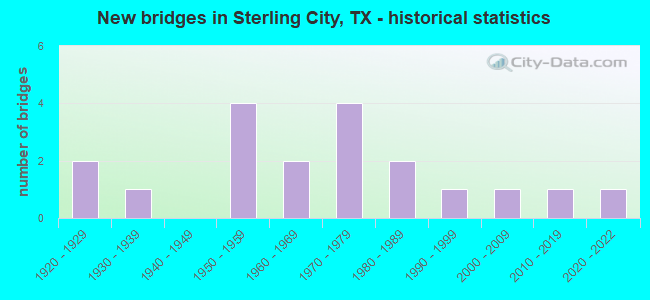
- New bridges - historical statistics
- 21920-1929
- 11930-1939
- 41950-1959
- 21960-1969
- 41970-1979
- 21980-1989
- 11990-1999
- 12000-2009
- 12010-2019
- 12020-2022

- Reconstructed bridges - Historical Statistics
- 51960-1969
- 01970-1979
- 01980-1989
- 01990-1999
- 02000-2009
- 12010-2019


- Bridge Condition - Deck
- 66.7%Good
- 33.3%Satisfactory

- Bridge Condition - Superstructure
- 33.3%Excellent
- 33.3%Good
- 33.3%Satisfactory

- Bridge Condition - Substructure
- 33.3%Very good
- 33.3%Good
- 33.3%Satisfactory

- Bridge Condition - Channel
- 5.9%Very good
- 88.2%Good
- 5.9%Satisfactory

- Bridge Condition - Culverts
- 73.3%Good
- 26.7%Satisfactory
Find on map >> Show street view
Structure Number: 72160006903015, Location: 4.92 MI SE GLASSCOCK C/L (Lat: 31.954208, Lng: -101.192389), Route carried "on" structure: US 87, Year Built: 2003, Status: Open, Structure Length: 2.56m (8.40ft), Average Daily Traffic: 2,612 (year 2020), Truck Traffic: 34%, Average Future Daily Traffic: 3,870 (year 2033), Design Load: HS 20, Features Intersected: GARDNER DRAW
Minimum Vertical Clearance: 30+ m (98+ ft), Kilometerpoint: 7.921, Lanes on structure: 4, Owner: State Highway Agency, Approaching Roadway Width: 23.2m (76.1ft), Skew: 20 degrees, Material/Design: Steel, Design/Construction: Culvert, Number Of Spans In Main Unit: 8, Length of Maximum Span: 2.4m (7.9ft)
Condition: Channel: Satisfactory, Culverts: Satisfactory, Operating Rating: 32.7 metric tons, Method Used To Determine Operating Rating: Field evaluation and documented engineering judgment, Inventory Rating: 24.5 metric tons, Method Used To Determine Inventory Rating: Field evaluation and documented engineering judgment, Structural Evaluation: Equal to present minimum criteria, Waterway Adequacy: Superior to present desirable criteria, Approach Roadway Alignment: Equal to present desirable criteria, Designated Inspection Frequency: Every 24 months, Inspection Date: July 2020
Find on map >> Show street view
Structure Number: 72160006903093, Location: 17.8 MI SE GLASSCOCK C/L (Lat: 31.843561, Lng: -101.023583), Route carried "on" structure: US 87, Year Built: 1967, Status: Open, Structure Length: 0.79m (2.59ft), Average Daily Traffic: 7,650 (year 2013), Truck Traffic: 24%, Average Future Daily Traffic: 10,710 (year 2033), Design Load: HS 20, Features Intersected: DRAW
Minimum Vertical Clearance: 30+ m (98+ ft), Kilometerpoint: 28.836, Lanes on structure: 4, Owner: State Highway Agency, Approaching Roadway Width: 23.8m (78.1ft), Skew: 20 degrees, Material/Design: Concrete, Design/Construction: Culvert, Number Of Spans In Main Unit: 3, Length of Maximum Span: 2.4m (7.9ft)
Condition: Channel: Good, Culverts: Good, Operating Rating: 39.9 metric tons, Method Used To Determine Operating Rating: Load Factor (LF), Inventory Rating: 23.6 metric tons, Method Used To Determine Inventory Rating: Load Factor (LF), Structural Evaluation: Somewhat better than minimum adequacy, Waterway Adequacy: Equal to present minimum criteria, Approach Roadway Alignment: Equal to present minimum criteria, Designated Inspection Frequency: Every 24 months, Inspection Date: July 2020
Find on map >> Show street view
Structure Number: 72160006903094, Location: 18.6 MI SE GLASSCOCK C/L (Lat: 31.839719, Lng: -101.012208), Route carried "on" structure: US 87, Year Built: 1967, Status: Open, Structure Length: 0.67m (2.20ft), Average Daily Traffic: 7,674 (year 2020), Truck Traffic: 21%, Average Future Daily Traffic: 13,010 (year 2033), Design Load: HS 20, Features Intersected: DRAW
Minimum Vertical Clearance: 30+ m (98+ ft), Kilometerpoint: 30.056, Lanes on structure: 4, Owner: State Highway Agency, Approaching Roadway Width: 24.4m (80.1ft), Skew: 20 degrees, Material/Design: Concrete, Design/Construction: Culvert, Number Of Spans In Main Unit: 2, Length of Maximum Span: 3.0m (9.8ft)
Condition: Channel: Good, Culverts: Good, Operating Rating: 39.9 metric tons, Method Used To Determine Operating Rating: Load Factor (LF), Inventory Rating: 23.6 metric tons, Method Used To Determine Inventory Rating: Load Factor (LF), Structural Evaluation: Somewhat better than minimum adequacy, Waterway Adequacy: Equal to present minimum criteria, Approach Roadway Alignment: Equal to present desirable criteria, Designated Inspection Frequency: Every 24 months, Inspection Date: July 2020
Find on map >> Show street view
Structure Number: 7216000690313, Location: 2.90 MI NW OF SH 163 (Lat: 31.855661, Lng: -101.037142), Route carried "on" structure: State highway 158, Year Built: 1989, Status: Open, Structure Length: 5.30m (17.39ft), Average Daily Traffic: 2,210 (year 2010), Truck Traffic: 24%, Average Future Daily Traffic: 3,090 (year 2028), Design Load: HS 20, Features Intersected: US 87 SB
Minimum Vertical Clearance: 30+ m (98+ ft), Kilometerpoint: 23.234, Lanes on structure: 1, Lanes under structure: 2, Owner: State Highway Agency, Approaching Roadway Width: 7.9m (25.9ft), Skew: 9 degrees, Material/Design: Prestressed concrete, Design/Construction: Box Beam or Girders - Multiple, Number Of Spans In Main Unit: 1, Number Of Approach Spans: 2, Length of Maximum Span: 23.2m (76.1ft), Curb-To-Curb Width: 7.7m (25.3ft), Out-to-Out Width: 8.5m (27.9ft)
Condition: Deck: Good, Superstructure: Good, Substructure: Good, Operating Rating: 54.4 metric tons, Method Used To Determine Operating Rating: Assigned rating based on Load Factor Design (LFD) reported in metric tons, Inventory Rating: 32.7 metric tons, Method Used To Determine Inventory Rating: Assigned rating based on Load Factor Design (LFD) reported in metric tons, Structural Evaluation: Better than present minimum criteria, Deck Geometry: High priority of replacement, Underclear: Equal to present minimum criteria, Approach Roadway Alignment: Equal to present desirable criteria, Designated Inspection Frequency: Every 24 months, Inspection Date: July 2020, Deck Structure Type: Concrete Precast Panels, Wearing Surface/Protective System: Wearing Surface: Bituminous
Find on map >> Show street view
Structure Number: 72160006903137, Location: 0.25 MI NW OF SH 163 (Lat: 31.864556, Lng: -101.046811), Route carried "on" structure: US 87, Year Built: 1997, Status: Open, Structure Length: 1.40m (4.59ft), Average Daily Traffic: 2,612 (year 2020), Truck Traffic: 34%, Average Future Daily Traffic: 3,870 (year 2033), Design Load: HS 20, Features Intersected: DRAW
Minimum Vertical Clearance: 30+ m (98+ ft), Kilometerpoint: 22.346, Lanes on structure: 4, Owner: State Highway Agency, Approaching Roadway Width: 23.2m (76.1ft), Skew: 20 degrees, Material/Design: Concrete, Design/Construction: Culvert, Number Of Spans In Main Unit: 6, Length of Maximum Span: 2.1m (6.9ft)
Condition: Channel: Good, Culverts: Good, Operating Rating: 39.9 metric tons, Method Used To Determine Operating Rating: Load Factor (LF), Inventory Rating: 23.6 metric tons, Method Used To Determine Inventory Rating: Load Factor (LF), Structural Evaluation: Equal to present minimum criteria, Waterway Adequacy: Superior to present desirable criteria, Approach Roadway Alignment: Equal to present desirable criteria, Designated Inspection Frequency: Every 48 months, Inspection Date: July 2018
Find on map >> Show street view
Structure Number: 7216000690403, Location: 0.40 MI W OF SH 158 (Lat: 31.836217, Lng: -100.982969), Route carried "on" structure: US 87, Year Built: 1929, Year Reconstructed: 1971, Status: Open, Structure Length: 2.13m (6.99ft), Average Daily Traffic: 7,998 (year 2020), Truck Traffic: 17%, Average Future Daily Traffic: 12,350 (year 2033), Design Load: H 15, Features Intersected: BODCAW DRAW
Minimum Vertical Clearance: 30+ m (98+ ft), Kilometerpoint: 1.046, Lanes on structure: 4, Owner: State Highway Agency, Approaching Roadway Width: 21.9m (71.9ft), Material/Design: Concrete, Design/Construction: Culvert, Number Of Spans In Main Unit: 8, Length of Maximum Span: 2.4m (7.9ft), Curb-To-Curb Width: 27.7m (90.9ft), Out-to-Out Width: 28.3m (92.8ft)
Condition: Channel: Good, Culverts: Satisfactory, Operating Rating: 39.9 metric tons, Method Used To Determine Operating Rating: Load Factor (LF), Inventory Rating: 23.6 metric tons, Method Used To Determine Inventory Rating: Load Factor (LF), Structural Evaluation: Somewhat better than minimum adequacy, Deck Geometry: Superior to present desirable criteria, Waterway Adequacy: Superior to present desirable criteria, Approach Roadway Alignment: Equal to present desirable criteria, Designated Inspection Frequency: Every 24 months, Inspection Date: July 2020, Deck Structure Type: Concrete Cast-file-Place, Wearing Surface/Protective System: Wearing Surface: Bituminous
Find on map >> Show street view
Structure Number: 72160006904033, Location: 1.50 MI SE OF SH 158 (Lat: 31.825772, Lng: -100.955181), Route carried "on" structure: US 87, Year Built: 1929, Year Reconstructed: 1971, Status: Open, Structure Length: 1.01m (3.31ft), Average Daily Traffic: 6,667 (year 2020), Truck Traffic: 17%, Average Future Daily Traffic: 9,330 (year 2033), Design Load: H 15, Features Intersected: DRAW
Minimum Vertical Clearance: 30+ m (98+ ft), Kilometerpoint: 4.059, Lanes on structure: 4, Owner: State Highway Agency, Approaching Roadway Width: 24.4m (80.1ft), Skew: 20 degrees, Material/Design: Concrete, Design/Construction: Culvert, Number Of Spans In Main Unit: 3, Length of Maximum Span: 3.0m (9.8ft)
Condition: Channel: Good, Culverts: Good, Operating Rating: 39.9 metric tons, Method Used To Determine Operating Rating: Load Factor (LF), Inventory Rating: 23.6 metric tons, Method Used To Determine Inventory Rating: Load Factor (LF), Structural Evaluation: Somewhat better than minimum adequacy, Waterway Adequacy: Superior to present desirable criteria, Approach Roadway Alignment: Equal to present desirable criteria, Designated Inspection Frequency: Every 24 months, Inspection Date: July 2020
Find on map >> Show street view
Structure Number: 72160006904085, Location: 0.30 MI E OF SH 158 (Lat: 31.835856, Lng: -100.970778), Route carried "on" structure: US 87, Year Built: 1955, Year Reconstructed: 1971, Status: Open, Structure Length: 0.67m (2.20ft), Average Daily Traffic: 6,667 (year 2020), Truck Traffic: 17%, Average Future Daily Traffic: 9,330 (year 2033), Design Load: H 20, Features Intersected: DRAW
Minimum Vertical Clearance: 30+ m (98+ ft), Kilometerpoint: 2.185, Lanes on structure: 4, Owner: State Highway Agency, Approaching Roadway Width: 24.4m (80.1ft), Skew: 20 degrees, Material/Design: Concrete, Design/Construction: Culvert, Number Of Spans In Main Unit: 2, Length of Maximum Span: 3.0m (9.8ft)
Condition: Channel: Good, Culverts: Good, Operating Rating: 39.9 metric tons, Method Used To Determine Operating Rating: Load Factor (LF), Inventory Rating: 23.6 metric tons, Method Used To Determine Inventory Rating: Load Factor (LF), Structural Evaluation: Somewhat better than minimum adequacy, Waterway Adequacy: Superior to present desirable criteria, Approach Roadway Alignment: Equal to present minimum criteria, Designated Inspection Frequency: Every 24 months, Inspection Date: July 2020
Find on map >> Show street view
Structure Number: 72160006904086, Location: 1.90 MI SE OF SH 158 (Lat: 31.820867, Lng: -100.949344), Route carried "on" structure: US 87, Year Built: 1955, Year Reconstructed: 1971, Status: Open, Structure Length: 0.70m (2.30ft), Average Daily Traffic: 6,667 (year 2020), Truck Traffic: 17%, Average Future Daily Traffic: 9,330 (year 2033), Design Load: H 20, Features Intersected: DRAW
Minimum Vertical Clearance: 30+ m (98+ ft), Kilometerpoint: 4.843, Lanes on structure: 5, Owner: State Highway Agency, Approaching Roadway Width: 24.4m (80.1ft), Skew: 20 degrees, Material/Design: Concrete, Design/Construction: Culvert, Number Of Spans In Main Unit: 3, Length of Maximum Span: 2.1m (6.9ft)
Condition: Channel: Good, Culverts: Satisfactory, Operating Rating: 39.9 metric tons, Method Used To Determine Operating Rating: Load Factor (LF), Inventory Rating: 23.6 metric tons, Method Used To Determine Inventory Rating: Load Factor (LF), Structural Evaluation: Somewhat better than minimum adequacy, Waterway Adequacy: Equal to present minimum criteria, Approach Roadway Alignment: Equal to present desirable criteria, Designated Inspection Frequency: Every 24 months, Inspection Date: July 2020
Find on map >> Show street view
Structure Number: 72160006904087, Location: 2.30 MI SE OF SH 158 (Lat: 31.816547, Lng: -100.944836), Route carried "on" structure: US 87, Year Built: 1955, Year Reconstructed: 1971, Status: Open, Structure Length: 0.70m (2.30ft), Average Daily Traffic: 6,667 (year 2020), Truck Traffic: 17%, Average Future Daily Traffic: 9,330 (year 2033), Design Load: H 20, Features Intersected: DRAW
Minimum Vertical Clearance: 30+ m (98+ ft), Kilometerpoint: 5.456, Lanes on structure: 4, Owner: State Highway Agency, Approaching Roadway Width: 24.4m (80.1ft), Skew: 20 degrees, Material/Design: Concrete, Design/Construction: Culvert, Number Of Spans In Main Unit: 3, Length of Maximum Span: 2.1m (6.9ft)
Condition: Channel: Good, Culverts: Satisfactory, Operating Rating: 39.9 metric tons, Method Used To Determine Operating Rating: Load Factor (LF), Inventory Rating: 23.6 metric tons, Method Used To Determine Inventory Rating: Load Factor (LF), Structural Evaluation: Somewhat better than minimum adequacy, Waterway Adequacy: Equal to present minimum criteria, Approach Roadway Alignment: Equal to present desirable criteria, Designated Inspection Frequency: Every 24 months, Inspection Date: July 2020
Find on map >> Show street view
Structure Number: 72160006904114, Location: 1.15 MI SE OF SH 158 (Lat: 31.829592, Lng: -100.959728), Route carried "on" structure: US 87, Year Built: 1971, Status: Open, Structure Length: 1.89m (6.20ft), Average Daily Traffic: 6,667 (year 2020), Truck Traffic: 17%, Average Future Daily Traffic: 9,330 (year 2033), Design Load: HS 20, Features Intersected: MACKENZIE DRAW
Minimum Vertical Clearance: 30+ m (98+ ft), Kilometerpoint: 3.499, Lanes on structure: 4, Owner: State Highway Agency, Approaching Roadway Width: 24.4m (80.1ft), Skew: 23 degrees, Material/Design: Concrete, Design/Construction: Culvert, Number Of Spans In Main Unit: 5, Length of Maximum Span: 3.0m (9.8ft)
Condition: Channel: Good, Culverts: Good, Operating Rating: 39.9 metric tons, Method Used To Determine Operating Rating: Load Factor (LF), Inventory Rating: 23.6 metric tons, Method Used To Determine Inventory Rating: Load Factor (LF), Structural Evaluation: Somewhat better than minimum adequacy, Waterway Adequacy: Superior to present desirable criteria, Approach Roadway Alignment: Equal to present desirable criteria, Designated Inspection Frequency: Every 24 months, Inspection Date: September 2020
Find on map >> Show street view
Structure Number: 72160040502002, Location: 0.65 MI W OF US 87 (Lat: 31.856033, Lng: -101.048222), Route carried "on" structure: State highway 158, Year Built: 1939, Year Reconstructed: 2015, Status: Open, Structure Length: 1.34m (4.40ft), Average Daily Traffic: 2,665 (year 2020), Truck Traffic: 26%, Average Future Daily Traffic: 5,610 (year 2033), Design Load: H 15, Features Intersected: DRAW
Minimum Vertical Clearance: 30+ m (98+ ft), Kilometerpoint: 22.294, Lanes on structure: 4, Owner: State Highway Agency, Approaching Roadway Width: 21.9m (71.9ft), Material/Design: Concrete, Design/Construction: Culvert, Number Of Spans In Main Unit: 5, Length of Maximum Span: 2.4m (7.9ft)
Condition: Channel: Very good, Culverts: Good, Operating Rating: 39.9 metric tons, Method Used To Determine Operating Rating: Load Factor (LF), Inventory Rating: 23.6 metric tons, Method Used To Determine Inventory Rating: Load Factor (LF), Structural Evaluation: Equal to present minimum criteria, Waterway Adequacy: Superior to present desirable criteria, Approach Roadway Alignment: Equal to present desirable criteria, Designated Inspection Frequency: Every 24 months, Inspection Date: July 2020
Find on map >> Show street view
Structure Number: 72160040601027, Location: 4.35 MI N OF US 87 (Lat: 31.895353, Lng: -100.955275), Route carried "on" structure: State highway 158, Year Built: 1974, Status: Open, Structure Length: 0.70m (2.30ft), Average Daily Traffic: 628 (year 2020), Truck Traffic: 14%, Average Future Daily Traffic: 2,110 (year 2033), Design Load: HS 20, Features Intersected: DRAW
Minimum Vertical Clearance: 30+ m (98+ ft), Kilometerpoint: 8.633, Lanes on structure: 2, Owner: State Highway Agency, Approaching Roadway Width: 13.4m (44.0ft), Material/Design: Concrete, Design/Construction: Culvert, Number Of Spans In Main Unit: 3, Length of Maximum Span: 2.1m (6.9ft)
Condition: Channel: Good, Culverts: Good, Operating Rating: 39.9 metric tons, Method Used To Determine Operating Rating: Load Factor (LF), Inventory Rating: 23.6 metric tons, Method Used To Determine Inventory Rating: Load Factor (LF), Structural Evaluation: Equal to present minimum criteria, Waterway Adequacy: Equal to present minimum criteria, Approach Roadway Alignment: Equal to present desirable criteria, Designated Inspection Frequency: Every 48 months, Inspection Date: July 2018
Find on map >> Show street view
Structure Number: 72160040601028, Location: 3.75 MI N OF US 87 (Lat: 31.887164, Lng: -100.956439), Route carried "on" structure: State highway 158, Year Built: 1974, Status: Open, Structure Length: 1.95m (6.40ft), Average Daily Traffic: 628 (year 2020), Truck Traffic: 14%, Average Future Daily Traffic: 2,110 (year 2033), Design Load: HS 20, Features Intersected: MACKENZIE DRAW
Minimum Vertical Clearance: 30+ m (98+ ft), Kilometerpoint: 7.648, Lanes on structure: 2, Owner: State Highway Agency, Approaching Roadway Width: 13.4m (44.0ft), Material/Design: Concrete, Design/Construction: Culvert, Number Of Spans In Main Unit: 6, Length of Maximum Span: 3.0m (9.8ft)
Condition: Channel: Good, Culverts: Good, Operating Rating: 39.9 metric tons, Method Used To Determine Operating Rating: Load Factor (LF), Inventory Rating: 23.6 metric tons, Method Used To Determine Inventory Rating: Load Factor (LF), Structural Evaluation: Equal to present minimum criteria, Waterway Adequacy: Equal to present minimum criteria, Approach Roadway Alignment: Equal to present desirable criteria, Designated Inspection Frequency: Every 48 months, Inspection Date: July 2018
Find on map >> Show street view
Structure Number: 72160040601029, Location: 1.10 MI N OF US 87 (Lat: 31.851708, Lng: -100.972197), Route carried "on" structure: State highway 158, Year Built: 1974, Status: Open, Structure Length: 0.73m (2.40ft), Average Daily Traffic: 628 (year 2020), Truck Traffic: 14%, Average Future Daily Traffic: 2,110 (year 2033), Design Load: HS 20, Features Intersected: DRAW
Minimum Vertical Clearance: 30+ m (98+ ft), Kilometerpoint: 3.449, Lanes on structure: 2, Owner: State Highway Agency, Approaching Roadway Width: 13.4m (44.0ft), Skew: 1 degrees, Material/Design: Concrete, Design/Construction: Culvert, Number Of Spans In Main Unit: 3, Length of Maximum Span: 2.1m (6.9ft)
Condition: Channel: Good, Culverts: Good, Operating Rating: 39.9 metric tons, Method Used To Determine Operating Rating: Load Factor (LF), Inventory Rating: 23.6 metric tons, Method Used To Determine Inventory Rating: Load Factor (LF), Structural Evaluation: Equal to present minimum criteria, Waterway Adequacy: Equal to present minimum criteria, Approach Roadway Alignment: Equal to present desirable criteria, Designated Inspection Frequency: Every 48 months, Inspection Date: July 2018
Find on map >> Show street view
Structure Number: 72160164801001, Location: 0.40 MI S OF US 87 (Lat: 31.829944, Lng: -100.993378), Route carried "on" structure: State highway 163, Year Built: 1954, Status: Open, Structure Length: 12.50m (41.01ft), Average Daily Traffic: 582 (year 2020), Truck Traffic: 25%, Average Future Daily Traffic: 2,520 (year 2033), Design Load: H 15, Features Intersected: NORTH CONCHO RIVER
Minimum Vertical Clearance: 30+ m (98+ ft), Kilometerpoint: 0.634, Lanes on structure: 2, Owner: State Highway Agency, Approaching Roadway Width: 7.9m (25.9ft), Material/Design: Steel continuous, Design/Construction: Stringer/Multi-beam, Number Of Spans In Main Unit: 3, Number Of Approach Spans: 10, Length of Maximum Span: 18.3m (60.0ft), Curb-To-Curb Width: 7.6m (24.9ft), Out-to-Out Width: 8.4m (27.6ft)
Condition: Deck: Satisfactory, Superstructure: Satisfactory, Substructure: Satisfactory, Channel: Good, Operating Rating: 44.4 metric tons, Method Used To Determine Operating Rating: Load Factor (LF), Inventory Rating: 26.3 metric tons, Method Used To Determine Inventory Rating: Load Factor (LF), Structural Evaluation: Equal to present minimum criteria, Deck Geometry: Meets minimum limits, Waterway Adequacy: Superior to present desirable criteria, Approach Roadway Alignment: Equal to present desirable criteria, Designated Inspection Frequency: Every 24 months, Inspection Date: July 2020, Deck Structure Type: Concrete Cast-file-Place, Wearing Surface/Protective System: Wearing Surface: Bituminous
Find on map >> Show street view
Structure Number: 72160AA0110005, Location: 0.8 Mi S of US 87 (Lat: 31.802939, Lng: -100.943617), Route carried "on" structure: County highway , Year Built: 2021, Status: Open, Structure Length: 5.79m (19.00ft), Average Daily Traffic: 30 (year 2021), Average Future Daily Traffic: 50 (year 2033), Design Load: HL 93, Features Intersected: North Concho River, Facility Carried by Structure: Sherwood Ln
Minimum Vertical Clearance: 30+ m (98+ ft), Kilometerpoint: 1.336, Lanes on structure: 2, Owner: County Highway Agency, Approaching Roadway Width: 9.1m (29.9ft), Material/Design: Prestressed concrete, Design/Construction: Stringer/Multi-beam, Number Of Spans In Main Unit: 3, Length of Maximum Span: 21.3m (69.9ft), Curb-To-Curb Width: 8.1m (26.6ft), Out-to-Out Width: 9.1m (29.9ft)
Condition: Deck: Good, Superstructure: Excellent, Substructure: Very good, Channel: Good, Operating Rating: 54.4 metric tons, Method Used To Determine Operating Rating: Assigned ratings based on Load and Resistance Factor Design (LRFD) reported in metric tons, Inventory Rating: 32.7 metric tons, Method Used To Determine Inventory Rating: Assigned ratings based on Load and Resistance Factor Design (LRFD) reported in metric tons, Structural Evaluation: Equal to present desirable criteria, Waterway Adequacy: Better than present minimum criteria, Approach Roadway Alignment: Equal to present desirable criteria, Designated Inspection Frequency: Every 24 months, Inspection Date: June 2021, Deck Structure Type: Concrete Cast-file-Place
Find on map >> Show street view
Structure Number: 72160AA0115002, Location: 0.45 MI SOUTH OF US 87 (Lat: 31.829975, Lng: -100.985328), Route carried "on" structure: County highway , Year Built: 2016, Status: Open, Structure Length: 1.10m (3.61ft), Average Daily Traffic: 50 (year 2013), Truck Traffic: 1%, Average Future Daily Traffic: 50 (year 2033), Design Load: HL 93, Features Intersected: NORTH CONCHO RIVER, Facility Carried by Structure: WASHINGTON STREET
Minimum Vertical Clearance: 30+ m (98+ ft), Kilometerpoint: 0.724, Lanes on structure: 2, Owner: County Highway Agency, Approaching Roadway Width: 4.6m (15.1ft), Skew: 1 degrees, Material/Design: Concrete, Design/Construction: Culvert, Number Of Spans In Main Unit: 4, Length of Maximum Span: 2.4m (7.9ft), Curb-To-Curb Width: 7.6m (24.9ft), Out-to-Out Width: 8.6m (28.2ft)
Condition: Channel: Good, Culverts: Good, Operating Rating: 54.4 metric tons, Method Used To Determine Operating Rating: Assigned ratings based on Load and Resistance Factor Design (LRFD) reported in metric tons, Inventory Rating: 32.7 metric tons, Method Used To Determine Inventory Rating: Assigned ratings based on Load and Resistance Factor Design (LRFD) reported in metric tons, Structural Evaluation: Better than present minimum criteria, Deck Geometry: Equal to present minimum criteria, Waterway Adequacy: Meets minimum limits, Approach Roadway Alignment: Equal to present desirable criteria, Designated Inspection Frequency: Every 24 months, Inspection Date: June 2021, Deck Structure Type: Concrete Cast-file-Place, Wearing Surface/Protective System: Wearing Surface: Bituminous
Find on map >> Show street view
Structure Number: 7216000690313, Location: 2.90 MI NW OF SH 163 (Lat: 31.855661, Lng: -101.037142), Route carried "under" structure: US 87, Year Built: 1989, Structure Length: 0. m, Average Daily Traffic: 3,820 (year 2013), Truck Traffic: 24%, Features Intersected: US 87 SB, Facility Carried by Structure: SH 158 WB
Minimum Vertical Clearance: 5.21m (17.09ft), Kilometerpoint: 26.984, Lanes on structure: 1, Lanes under structure: 2, Material/Design: Prestressed concrete, Design/Construction: Box Beam or Girders - Multiple, Length of Maximum Span: 23.2m (76.1ft)