Bridge Statistics for Santaquin, Utah (UT)
Condition, Traffic, Stress, Structural Evaluation, Project Costs
- National Bridge Inventory (NBI) Statistics
- 22Number of bridges
- 128ft / 38.8mTotal length
- 258,140Total average daily traffic
- 54,628Total average daily truck traffic
- National Bridge Inventory (NBI) Registered Bridges for Santaquin
- No street view available for this location
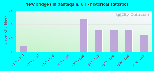
- New bridges - historical statistics
- 11920-1929
- 61960-1969
- 41970-1979
- 41980-1989
- 41990-1999
- 32000-2009
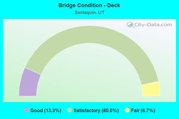
- Bridge Condition - Deck
- 13.3%Good
- 80.0%Satisfactory
- 6.7%Fair
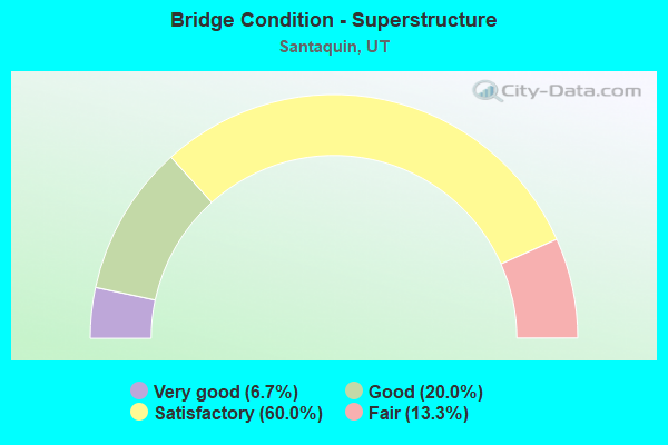
- Bridge Condition - Superstructure
- 6.7%Very good
- 20.0%Good
- 60.0%Satisfactory
- 13.3%Fair
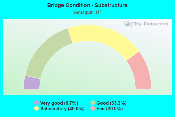
- Bridge Condition - Substructure
- 6.7%Very good
- 33.3%Good
- 40.0%Satisfactory
- 20.0%Fair
Find on map >> Show street view
Structure Number: 49052D, Location: 12900 S. 6250 W., SNTQUN. (Lat: 39.994475, Lng: -111.802817), Route carried "on" structure: County highway , Year Built: 2003, Status: Open, Structure Length: 0.68m (2.23ft), Average Daily Traffic: 19 (year 2020), Truck Traffic: 1%, Average Future Daily Traffic: 24 (year 2040), Design Load: HL 93, Features Intersected: HIGHLAND CANAL, Facility Carried by Structure: CO.RD,6250 WEST ST
Minimum Vertical Clearance: 30+ m (98+ ft), Kilometerpoint: 0.205, Lanes on structure: 2, Owner: County Highway Agency, Approaching Roadway Width: 12.8m (42.0ft), Skew: 1 degrees, Material/Design: Concrete, Design/Construction: Slab, Number Of Spans In Main Unit: 1, Length of Maximum Span: 6.2m (20.3ft), Curb-To-Curb Width: 12.8m (42.0ft), Out-to-Out Width: 13.3m (43.6ft)
Condition: Deck: Satisfactory, Superstructure: Satisfactory, Substructure: Good, Channel: Good, Operating Rating: 47.6 metric tons, Method Used To Determine Operating Rating: Load and Resistance Factor Rating (LRFR) rating reported by rating factor(RF) method using HL-93 loadings, Inventory Rating: 38.6 metric tons, Method Used To Determine Inventory Rating: Load and Resistance Factor Rating (LRFR) rating reported by rating factor(RF) method using HL-93 loadings, Structural Evaluation: Equal to present minimum criteria, Deck Geometry: Superior to present desirable criteria, Waterway Adequacy: Equal to present desirable criteria, Approach Roadway Alignment: Equal to present minimum criteria, Designated Inspection Frequency: Every 24 months, Inspection Date: October 2021, Deck Structure Type: Concrete Cast-file-Place, Wearing Surface/Protective System: Wearing Surface: Integral Concrete
Find on map >> Show street view
Structure Number: 49053D, Location: 12875 S.6000 W.,N.OF STQN (Lat: 39.995350, Lng: -111.797136), Route carried "on" structure: County highway , Year Built: 1998, Status: Open, Structure Length: 0.68m (2.23ft), Average Daily Traffic: 26 (year 2020), Average Future Daily Traffic: 32 (year 2040), Design Load: HS 20+Mod, Features Intersected: HIGHLINE CANAL, Facility Carried by Structure: CO.RD.,6000 W.ST.
Minimum Vertical Clearance: 30+ m (98+ ft), Kilometerpoint: 0.387, Lanes on structure: 2, Owner: County Highway Agency, Approaching Roadway Width: 12.6m (41.3ft), Skew: 1 degrees, Material/Design: Concrete, Design/Construction: Frame, Number Of Spans In Main Unit: 1, Length of Maximum Span: 6.2m (20.3ft), Curb-To-Curb Width: 12.6m (41.3ft), Out-to-Out Width: 13.1m (43.0ft)
Condition: Deck: Satisfactory, Superstructure: Satisfactory, Substructure: Good, Channel: Good, Operating Rating: 31.4 metric tons, Method Used To Determine Operating Rating: Load Factor (LF) rating reported by rating factor (RF) method using MS18 loading, Inventory Rating: 20.1 metric tons, Method Used To Determine Inventory Rating: Load Factor (LF) rating reported by rating factor (RF) method using MS18 loading, Structural Evaluation: Somewhat better than minimum adequacy, Deck Geometry: Superior to present desirable criteria, Waterway Adequacy: Equal to present desirable criteria, Approach Roadway Alignment: Equal to present desirable criteria, Bridge Posting: Required (Relationship of Operating Rating to Maximum Legal Load: 0.1 - 9.9% below), Designated Inspection Frequency: Every 24 months, Inspection Date: October 2021, Deck Structure Type: Concrete Cast-file-Place, Wearing Surface/Protective System: Wearing Surface: Monolithic Concrete, Deck Protection: Epoxy Coated Reinforcing
Find on map >> Show street view
Structure Number: 49054D, Location: 12875 S.5950 W.,N.OF STQN (Lat: 39.995825, Lng: -111.794067), Route carried "on" structure: County highway , Year Built: 1998, Status: Open, Structure Length: 0.68m (2.23ft), Average Daily Traffic: 63 (year 2020), Average Future Daily Traffic: 77 (year 2040), Design Load: HS 20+Mod, Features Intersected: HIGHLINE CANAL, Facility Carried by Structure: CO.RD.,5950 SO.ST.
Minimum Vertical Clearance: 30+ m (98+ ft), Kilometerpoint: 0.022, Lanes on structure: 2, Owner: County Highway Agency, Approaching Roadway Width: 12.6m (41.3ft), Skew: 1 degrees, Material/Design: Concrete, Design/Construction: Frame, Number Of Spans In Main Unit: 1, Length of Maximum Span: 6.2m (20.3ft), Curb-To-Curb Width: 12.6m (41.3ft), Out-to-Out Width: 13.1m (43.0ft)
Condition: Deck: Satisfactory, Superstructure: Satisfactory, Substructure: Good, Channel: Good, Operating Rating: 32.4 metric tons, Method Used To Determine Operating Rating: Load and Resistance Factor Rating (LRFR) rating reported by rating factor(RF) method using HL-93 loadings, Inventory Rating: 32.1 metric tons, Method Used To Determine Inventory Rating: Load and Resistance Factor Rating (LRFR) rating reported by rating factor(RF) method using HL-93 loadings, Structural Evaluation: Equal to present minimum criteria, Deck Geometry: Superior to present desirable criteria, Waterway Adequacy: Equal to present desirable criteria, Approach Roadway Alignment: Equal to present desirable criteria, Designated Inspection Frequency: Every 24 months, Inspection Date: October 2021, Deck Structure Type: Concrete Cast-file-Place, Wearing Surface/Protective System: Wearing Surface: Monolithic Concrete, Deck Protection: Epoxy Coated Reinforcing
Find on map >> Show street view
Structure Number: 49056C, Location: 1180 N. 200 E., SANTAQUIN (Lat: 39.994753, Lng: -111.780761), Route carried "on" structure: City street , Year Built: 1925, Status: Posted for load, Structure Length: 0.83m (2.72ft), Average Daily Traffic: 53 (year 2020), Average Future Daily Traffic: 65 (year 2040), Design Load: HL 93, Features Intersected: HIGHLINE CANAL, Facility Carried by Structure: 200 EAST STREET
Minimum Vertical Clearance: 30+ m (98+ ft), Kilometerpoint: 0.769, Lanes on structure: 1, Owner: City or Municipal Highway Agency, Approaching Roadway Width: 4.9m (16.1ft), Material/Design: Steel, Design/Construction: Stringer/Multi-beam, Number Of Spans In Main Unit: 1, Length of Maximum Span: 7.8m (25.6ft), Curb-To-Curb Width: 4.9m (16.1ft), Out-to-Out Width: 4.9m (16.1ft)
Condition: Deck: Fair, Superstructure: Satisfactory, Substructure: Satisfactory, Channel: Good, Operating Rating: 8.1 metric tons, Method Used To Determine Operating Rating: Load Factor (LF) rating reported by rating factor (RF) method using MS18 loading, Inventory Rating: 0.3 metric tons, Method Used To Determine Inventory Rating: Load Factor (LF) rating reported by rating factor (RF) method using MS18 loading, Structural Evaluation: High priority of corrective action, Deck Geometry: High priority of corrective action, Waterway Adequacy: Somewhat better than minimum adequacy, Approach Roadway Alignment: Equal to present minimum criteria, Bridge Posting: Required (Relationship of Operating Rating to Maximum Legal Load: > 39.9% below), Designated Inspection Frequency: Every 24 months, Inspection Date: October 2021, Deck Structure Type: Corrugated Steel, Wearing Surface/Protective System: Wearing Surface: Bituminous
Find on map >> Show street view
Structure Number: 49057D, Location: 12950 S.5200 W.,N.OF STQN (Lat: 39.993700, Lng: -111.776986), Route carried "on" structure: County highway , Year Built: 1998, Status: Posted for load, Structure Length: 0.76m (2.49ft), Average Daily Traffic: 222 (year 2020), Truck Traffic: 4%, Average Future Daily Traffic: 270 (year 2040), Design Load: HS 20+Mod, Features Intersected: HIGHLINE CANAL, Facility Carried by Structure: CO.RD.,5200 W.ST.
Minimum Vertical Clearance: 30+ m (98+ ft), Kilometerpoint: 0.012, Lanes on structure: 2, Owner: City or Municipal Highway Agency, Approaching Roadway Width: 12.6m (41.3ft), Skew: 2 degrees, Material/Design: Concrete, Design/Construction: Frame, Number Of Spans In Main Unit: 1, Length of Maximum Span: 6.9m (22.6ft), Curb-To-Curb Width: 12.6m (41.3ft), Out-to-Out Width: 13.1m (43.0ft)
Condition: Deck: Satisfactory, Superstructure: Satisfactory, Substructure: Good, Channel: Good, Operating Rating: 37.3 metric tons, Method Used To Determine Operating Rating: Load and Resistance Factor Rating (LRFR) rating reported by rating factor(RF) method using HL-93 loadings, Inventory Rating: 32.1 metric tons, Method Used To Determine Inventory Rating: Load Factor (LF) rating reported by rating factor (RF) method using MS18 loading, Structural Evaluation: Equal to present minimum criteria, Deck Geometry: Superior to present desirable criteria, Waterway Adequacy: Equal to present desirable criteria, Approach Roadway Alignment: Equal to present desirable criteria, Designated Inspection Frequency: Every 24 months, Inspection Date: October 2021, Deck Structure Type: Concrete Cast-file-Place, Wearing Surface/Protective System: Wearing Surface: Monolithic Concrete, Deck Protection: Epoxy Coated Reinforcing
Find on map >> Show street view
Structure Number: 49058C, Location: 13300 S.4800 W.,N.SNTQUIN (Lat: 39.987750, Lng: -111.767478), Route carried "on" structure: County highway , Year Built: 1990, Status: Open, Structure Length: 1.23m (4.04ft), Average Daily Traffic: 158 (year 2020), Truck Traffic: 5%, Average Future Daily Traffic: 192 (year 2040), Design Load: HL 93, Features Intersected: HIGHLINE CANAL, Facility Carried by Structure: CO.RD.4800 WEST ST
Minimum Vertical Clearance: 30+ m (98+ ft), Kilometerpoint: 0.551, Lanes on structure: 2, Owner: City or Municipal Highway Agency, Approaching Roadway Width: 7.2m (23.6ft), Skew: 4 degrees, Material/Design: Steel, Design/Construction: Stringer/Multi-beam, Number Of Spans In Main Unit: 1, Length of Maximum Span: 11.3m (37.1ft), Curb-To-Curb Width: 7.2m (23.6ft), Out-to-Out Width: 7.2m (23.6ft)
Condition: Deck: Satisfactory, Superstructure: Satisfactory, Substructure: Good, Channel: Good, Operating Rating: 18.8 metric tons, Method Used To Determine Operating Rating: Load Factor (LF) rating reported by rating factor (RF) method using MS18 loading, Inventory Rating: 13.0 metric tons, Method Used To Determine Inventory Rating: Load Factor (LF) rating reported by rating factor (RF) method using MS18 loading, Structural Evaluation: Meets minimum limits, Deck Geometry: Meets minimum limits, Waterway Adequacy: Equal to present minimum criteria, Approach Roadway Alignment: Equal to present desirable criteria, Bridge Posting: Required (Relationship of Operating Rating to Maximum Legal Load: > 39.9% below), Designated Inspection Frequency: Every 24 months, Inspection Date: October 2021, Deck Structure Type: Corrugated Steel, Wearing Surface/Protective System: Wearing Surface: Bituminous
Find on map >> Show street view
Structure Number: 49093F, Location: SUMMIT RIDGE S. OF SANTAQ (Lat: 39.949867, Lng: -111.816397), Route carried "on" structure: City street 2871, Year Built: 2007, Status: Open, Structure Length: 4.61m (15.12ft), Average Daily Traffic: 1,000 (year 2020), Average Future Daily Traffic: 1,250 (year 2040), Design Load: HS 25 or greater, Features Intersected: UNION PACIFIC RAILROAD, Facility Carried by Structure: SUMMIT RIDGE PKWY.
Minimum Vertical Clearance: 30+ m (98+ ft), Kilometerpoint: 1.331, Lanes on structure: 2, Owner: City or Municipal Highway Agency, Approaching Roadway Width: 26.5m (86.9ft), Skew: 20 degrees, Material/Design: Prestressed concrete, Design/Construction: Stringer/Multi-beam, Number Of Spans In Main Unit: 1, Length of Maximum Span: 45.6m (149.6ft), Curb or Sidewalk Widths: Left: 2.1m (6.9ft), Right: 2.1m (6.9ft), Curb-To-Curb Width: 7.4m (24.3ft), Out-to-Out Width: 20.1m (65.9ft)
Condition: Deck: Satisfactory, Superstructure: Satisfactory, Substructure: Satisfactory, Operating Rating: 32.4 metric tons, Method Used To Determine Operating Rating: Load and Resistance Factor Rating (LRFR) rating reported by rating factor(RF) method using HL-93 loadings, Inventory Rating: 22.7 metric tons, Method Used To Determine Inventory Rating: Load Factor (LF) rating reported by rating factor (RF) method using MS18 loading, Structural Evaluation: Equal to present minimum criteria, Deck Geometry: Meets minimum limits, Underclear: Superior to present desirable criteria, Approach Roadway Alignment: Equal to present desirable criteria, Designated Inspection Frequency: Every 24 months, Inspection Date: October 2021, Deck Structure Type: Concrete Cast-file-Place, Wearing Surface/Protective System: Wearing Surface: Latex Concrete, Deck Protection: Epoxy Coated Reinforcing
Find on map >> Show street view
Structure Number: D 749, Location: 2.1 MI NO OF SANTAQUIN (Lat: 40.004669, Lng: -111.763000), Route carried "on" structure: County highway 2854, Year Built: 1967, Status: Open, Structure Length: 5.81m (19.06ft), Average Daily Traffic: 2,013 (year 2020), Average Future Daily Traffic: 2,516 (year 2040), Design Load: HS 20+Mod, Features Intersected: I-15 (SR-15) NBL & S, Facility Carried by Structure: 12400 South
Minimum Vertical Clearance: 30+ m (98+ ft), Kilometerpoint: 6.888, Lanes on structure: 2, Lanes under structure: 4, Owner: State Highway Agency, Approaching Roadway Width: 7.3m (24.0ft), Material/Design: Concrete continuous, Design/Construction: Tee Beam, Number Of Spans In Main Unit: 4, Length of Maximum Span: 21.3m (69.9ft), Curb or Sidewalk Widths: Left: 0.6m (2.0ft), Right: 0.6m (2.0ft), Curb-To-Curb Width: 7.3m (24.0ft), Out-to-Out Width: 9.0m (29.5ft)
Condition: Deck: Satisfactory, Superstructure: Good, Substructure: Fair, Operating Rating: 34.0 metric tons, Method Used To Determine Operating Rating: Load and Resistance Factor Rating (LRFR) rating reported by rating factor(RF) method using HL-93 loadings, Inventory Rating: 33.7 metric tons, Method Used To Determine Inventory Rating: Load Factor (LF) rating reported by rating factor (RF) method using MS18 loading, Structural Evaluation: Somewhat better than minimum adequacy, Deck Geometry: High priority of replacement, Underclear: Meets minimum limits, Approach Roadway Alignment: Somewhat better than minimum adequacy, Designated Inspection Frequency: Every 24 months, Inspection Date: March 2021, Deck Structure Type: Concrete Cast-file-Place, Wearing Surface/Protective System: Wearing Surface: Bituminous, Membrane: Preformed Fabric
Find on map >> Show street view
Structure Number: F 722, Location: 1.1 MI. WEST OF SANTAQUIN (Lat: 39.980622, Lng: -111.803900), Route carried "on" structure: US 6, Year Built: 2005, Status: Open, Structure Length: 3.06m (10.04ft), Average Daily Traffic: 4,446 (year 2020), Truck Traffic: 26%, Average Future Daily Traffic: 5,558 (year 2040), Design Load: HL 93, Features Intersected: UNION PACIFIC RAILROAD
Minimum Vertical Clearance: 30+ m (98+ ft), Kilometerpoint: 255.553, Lanes on structure: 2, Owner: State Highway Agency, Approaching Roadway Width: 16.5m (54.1ft), Material/Design: Prestressed concrete, Design/Construction: Stringer/Multi-beam, Number Of Spans In Main Unit: 1, Length of Maximum Span: 29.7m (97.4ft), Curb-To-Curb Width: 16.5m (54.1ft), Out-to-Out Width: 17.4m (57.1ft)
Condition: Deck: Good, Superstructure: Good, Substructure: Very good, Operating Rating: 33.4 metric tons, Method Used To Determine Operating Rating: Load and Resistance Factor Rating (LRFR) rating reported by rating factor(RF) method using HL-93 loadings, Inventory Rating: 33.0 metric tons, Method Used To Determine Inventory Rating: Load and Resistance Factor Rating (LRFR) rating reported by rating factor(RF) method using HL-93 loadings, Structural Evaluation: Better than present minimum criteria, Deck Geometry: Superior to present desirable criteria, Underclear: Superior to present desirable criteria, Approach Roadway Alignment: Equal to present desirable criteria, Designated Inspection Frequency: Every 24 months, Inspection Date: March 2021, Deck Structure Type: Concrete Cast-file-Place, Wearing Surface/Protective System: Wearing Surface: Epoxy Overlay, Deck Protection: Epoxy Coated Reinforcing
Find on map >> Show street view
Structure Number: 1C 763, Location: SW.SIDE OF SANTAQUIN (Lat: 39.965683, Lng: -111.785197), Route carried "on" structure: Interstate 15, Year Built: 1989, Status: Open, Structure Length: 2.85m (9.35ft), Average Daily Traffic: 29,829 (year 2020), Truck Traffic: 23%, Average Future Daily Traffic: 37,286 (year 2040), Design Load: HS 20+Mod, Features Intersected: SANTAQUIN CANYON ROAD
Minimum Vertical Clearance: 30+ m (98+ ft), Kilometerpoint: 392.953, Lanes on structure: 2, Lanes under structure: 2, Base Highway Network: Yes, Owner: State Highway Agency, Approaching Roadway Width: 11.6m (38.1ft), Skew: 3 degrees, Material/Design: Steel, Design/Construction: Stringer/Multi-beam, Number Of Spans In Main Unit: 1, Length of Maximum Span: 27.4m (89.9ft), Curb-To-Curb Width: 12.8m (42.0ft), Out-to-Out Width: 13.8m (45.3ft)
Condition: Deck: Satisfactory, Superstructure: Very good, Substructure: Satisfactory, Operating Rating: 69.3 metric tons, Method Used To Determine Operating Rating: Load and Resistance Factor Rating (LRFR) rating reported by rating factor(RF) method using HL-93 loadings, Inventory Rating: 56.1 metric tons, Method Used To Determine Inventory Rating: Load Factor (LF) rating reported by rating factor (RF) method using MS18 loading, Structural Evaluation: Equal to present minimum criteria, Deck Geometry: Equal to present desirable criteria, Underclear: Meets minimum limits, Approach Roadway Alignment: Equal to present desirable criteria, Designated Inspection Frequency: Every 24 months, Inspection Date: March 2021, Deck Structure Type: Concrete Cast-file-Place, Wearing Surface/Protective System: Wearing Surface: Monolithic Concrete, Deck Protection: Epoxy Coated Reinforcing
Find on map >> Show street view
Structure Number: 1F 128, Location: SANTAQUIN INTERCHANGE (Lat: 39.975336, Lng: -111.772417), Route carried "on" structure: Interstate 15, Year Built: 1967, Year Reconstructed: 2011, Status: Open, Structure Length: 4.18m (13.71ft), Average Daily Traffic: 29,829 (year 2020), Truck Traffic: 23%, Average Future Daily Traffic: 37,286 (year 2040), Design Load: HS 20+Mod, Features Intersected: US-6 (SR-6), INT. X-ROAD
Minimum Vertical Clearance: 30+ m (98+ ft), Kilometerpoint: 394.484, Lanes on structure: 2, Lanes under structure: 3, Base Highway Network: Yes, Owner: State Highway Agency, Approaching Roadway Width: 11.6m (38.1ft), Skew: 3 degrees, Material/Design: Prestressed concrete, Design/Construction: Stringer/Multi-beam, Number Of Spans In Main Unit: 3, Length of Maximum Span: 18.0m (59.1ft), Curb-To-Curb Width: 11.1m (36.4ft), Out-to-Out Width: 12.1m (39.7ft)
Condition: Deck: Satisfactory, Superstructure: Fair, Substructure: Fair, Operating Rating: 38.6 metric tons, Method Used To Determine Operating Rating: Load and Resistance Factor Rating (LRFR) rating reported by rating factor(RF) method using HL-93 loadings, Inventory Rating: 25.3 metric tons, Method Used To Determine Inventory Rating: Load and Resistance Factor Rating (LRFR) rating reported by rating factor(RF) method using HL-93 loadings, Structural Evaluation: Somewhat better than minimum adequacy, Deck Geometry: Somewhat better than minimum adequacy, Underclear: High priority of corrective action, Approach Roadway Alignment: Equal to present desirable criteria, Designated Inspection Frequency: Every 24 months, Inspection Date: March 2021, Deck Structure Type: Concrete Precast Panels, Wearing Surface/Protective System: Wearing Surface: Epoxy Overlay, Deck Protection: Epoxy Coated Reinforcing
Find on map >> Show street view
Structure Number: 1F 197, Location: SO.SANTAQUIN INTERCHANGE (Lat: 39.950400, Lng: -111.802653), Route carried "on" structure: Interstate 15, Year Built: 1973, Status: Open, Structure Length: 3.19m (10.47ft), Average Daily Traffic: 27,142 (year 2020), Truck Traffic: 25%, Average Future Daily Traffic: 33,928 (year 2040), Design Load: HS 20+Mod, Features Intersected: COUNTY RD.INT.X-ROAD.
Minimum Vertical Clearance: 30+ m (98+ ft), Kilometerpoint: 390.682, Lanes on structure: 2, Lanes under structure: 3, Base Highway Network: Yes, Owner: State Highway Agency, Approaching Roadway Width: 11.6m (38.1ft), Material/Design: Prestressed concrete, Design/Construction: Stringer/Multi-beam, Number Of Spans In Main Unit: 1, Length of Maximum Span: 31.1m (102.0ft), Curb-To-Curb Width: 12.3m (40.4ft), Out-to-Out Width: 13.4m (44.0ft)
Condition: Deck: Good, Superstructure: Satisfactory, Substructure: Satisfactory, Operating Rating: 35.3 metric tons, Method Used To Determine Operating Rating: Load Factor (LF) rating reported by rating factor (RF) method using MS18 loading, Inventory Rating: 22.7 metric tons, Method Used To Determine Inventory Rating: Load Factor (LF) rating reported by rating factor (RF) method using MS18 loading, Structural Evaluation: Somewhat better than minimum adequacy, Deck Geometry: Better than present minimum criteria, Underclear: Meets minimum limits, Approach Roadway Alignment: Equal to present desirable criteria, Designated Inspection Frequency: Every 24 months, Inspection Date: March 2021, Deck Structure Type: Concrete Cast-file-Place, Wearing Surface/Protective System: Wearing Surface: Bituminous, Membrane: Preformed Fabric
Find on map >> Show street view
Structure Number: 3C 763, Location: SW SIDE OF SANTAQUIN (Lat: 39.966239, Lng: -111.784903), Route carried "on" structure: Interstate 15, Year Built: 1989, Status: Open, Structure Length: 2.85m (9.35ft), Average Daily Traffic: 29,829 (year 2020), Truck Traffic: 23%, Average Future Daily Traffic: 37,286 (year 2040), Design Load: HS 20+Mod, Features Intersected: SANTAQUIN CANYON ROAD
Minimum Vertical Clearance: 30+ m (98+ ft), Kilometerpoint: 392.835, Lanes on structure: 2, Lanes under structure: 2, Base Highway Network: Yes, Owner: State Highway Agency, Approaching Roadway Width: 11.6m (38.1ft), Skew: 3 degrees, Material/Design: Steel, Design/Construction: Stringer/Multi-beam, Number Of Spans In Main Unit: 1, Length of Maximum Span: 27.4m (89.9ft), Curb-To-Curb Width: 12.8m (42.0ft), Out-to-Out Width: 13.8m (45.3ft)
Condition: Deck: Satisfactory, Superstructure: Good, Substructure: Satisfactory, Operating Rating: 71.9 metric tons, Method Used To Determine Operating Rating: Load and Resistance Factor Rating (LRFR) rating reported by rating factor(RF) method using HL-93 loadings, Inventory Rating: 48.0 metric tons, Method Used To Determine Inventory Rating: Load and Resistance Factor Rating (LRFR) rating reported by rating factor(RF) method using HL-93 loadings, Structural Evaluation: Equal to present minimum criteria, Deck Geometry: Equal to present desirable criteria, Underclear: Meets minimum limits, Approach Roadway Alignment: Equal to present desirable criteria, Designated Inspection Frequency: Every 24 months, Inspection Date: March 2021, Deck Structure Type: Concrete Cast-file-Place, Wearing Surface/Protective System: Wearing Surface: Monolithic Concrete, Deck Protection: Epoxy Coated Reinforcing
Find on map >> Show street view
Structure Number: 3F 128, Location: SANTAQUIN INTERCHANGE (Lat: 39.975789, Lng: -111.772367), Route carried "on" structure: Interstate 15, Year Built: 1967, Year Reconstructed: 2011, Status: Open, Structure Length: 4.18m (13.71ft), Average Daily Traffic: 29,829 (year 2020), Truck Traffic: 23%, Average Future Daily Traffic: 37,286 (year 2040), Design Load: HS 20+Mod, Features Intersected: SANTAQUIN MAIN ST
Minimum Vertical Clearance: 30+ m (98+ ft), Kilometerpoint: 394.343, Lanes on structure: 2, Lanes under structure: 3, Base Highway Network: Yes, Owner: State Highway Agency, Approaching Roadway Width: 11.6m (38.1ft), Skew: 3 degrees, Material/Design: Prestressed concrete, Design/Construction: Stringer/Multi-beam, Number Of Spans In Main Unit: 3, Length of Maximum Span: 18.0m (59.1ft), Curb-To-Curb Width: 11.1m (36.4ft), Out-to-Out Width: 12.1m (39.7ft)
Condition: Deck: Satisfactory, Superstructure: Fair, Substructure: Fair, Operating Rating: 46.7 metric tons, Method Used To Determine Operating Rating: Load and Resistance Factor Rating (LRFR) rating reported by rating factor(RF) method using HL-93 loadings, Inventory Rating: 28.2 metric tons, Method Used To Determine Inventory Rating: Load and Resistance Factor Rating (LRFR) rating reported by rating factor(RF) method using HL-93 loadings, Structural Evaluation: Somewhat better than minimum adequacy, Deck Geometry: Somewhat better than minimum adequacy, Underclear: High priority of corrective action, Approach Roadway Alignment: Equal to present desirable criteria, Designated Inspection Frequency: Every 24 months, Inspection Date: March 2021, Deck Structure Type: Concrete Precast Panels, Wearing Surface/Protective System: Wearing Surface: Epoxy Overlay, Deck Protection: Epoxy Coated Reinforcing
Find on map >> Show street view
Structure Number: 3F 197, Location: SO.SANTAQUIN INTERCHANGE (Lat: 39.950878, Lng: -111.802639), Route carried "on" structure: Interstate 15, Year Built: 1973, Status: Open, Structure Length: 3.19m (10.47ft), Average Daily Traffic: 27,142 (year 2020), Truck Traffic: 25%, Average Future Daily Traffic: 33,928 (year 2040), Design Load: HS 20+Mod, Features Intersected: COUNTY RD INT X-ROAD
Minimum Vertical Clearance: 30+ m (98+ ft), Kilometerpoint: 390.542, Lanes on structure: 2, Lanes under structure: 3, Base Highway Network: Yes, Owner: State Highway Agency, Approaching Roadway Width: 11.6m (38.1ft), Material/Design: Prestressed concrete, Design/Construction: Stringer/Multi-beam, Number Of Spans In Main Unit: 1, Length of Maximum Span: 31.1m (102.0ft), Curb-To-Curb Width: 12.3m (40.4ft), Out-to-Out Width: 13.4m (44.0ft)
Condition: Deck: Satisfactory, Superstructure: Satisfactory, Substructure: Satisfactory, Operating Rating: 35.3 metric tons, Method Used To Determine Operating Rating: Load and Resistance Factor Rating (LRFR) rating reported by rating factor(RF) method using HL-93 loadings, Inventory Rating: 15.9 metric tons, Method Used To Determine Inventory Rating: Load Factor (LF) rating reported by rating factor (RF) method using MS18 loading, Structural Evaluation: High priority of corrective action, Deck Geometry: Better than present minimum criteria, Underclear: Meets minimum limits, Approach Roadway Alignment: Equal to present desirable criteria, Designated Inspection Frequency: Every 24 months, Inspection Date: March 2021, Deck Structure Type: Concrete Cast-file-Place, Wearing Surface/Protective System: Wearing Surface: Bituminous, Membrane: Preformed Fabric
Find on map >> Show street view
Structure Number: D 749, Location: 2.1 MI NO OF SANTAQUIN (Lat: 40.004669, Lng: -111.763000), Route carried "under" structure: Interstate 15, Year Built: 1967, Structure Length: 0. m, Average Daily Traffic: 42,776 (year 2020), Truck Traffic: 22%, Features Intersected: I-15 (SR-15) NBL & S, Facility Carried by Structure: 12400 South
Minimum Vertical Clearance: 4.93m (16.17ft), Kilometerpoint: 397.389, Lanes on structure: 2, Lanes under structure: 4, Material/Design: Concrete continuous, Design/Construction: Tee Beam, Length of Maximum Span: 21.3m (69.9ft)
Find on map >> Show street view
Structure Number: 1C 763, Location: SW.SIDE OF SANTAQUIN (Lat: 39.965683, Lng: -111.785197), Route carried "under" structure: County highway , Year Built: 1989, Structure Length: 0. m, Features Intersected: SANTAQUIN CANYON ROAD, Facility Carried by Structure: I-15 (SR-15) NBL
Minimum Vertical Clearance: 4.85m (15.91ft), Kilometerpoint: 0.000, Lanes on structure: 2, Lanes under structure: 2, Material/Design: Steel, Design/Construction: Stringer/Multi-beam, Length of Maximum Span: 27.4m (89.9ft)
Find on map >> Show street view
Structure Number: 1F 128, Location: SANTAQUIN INTERCHANGE (Lat: 39.975336, Lng: -111.772417), Route carried "under" structure: US 6, Year Built: 1967, Structure Length: 0. m, Average Daily Traffic: 16,882 (year 2020), Truck Traffic: 9%, Features Intersected: US-6 (SR-6), INT. X-ROAD, Facility Carried by Structure: I-15 (SR-15) NBL
Minimum Vertical Clearance: 4.72m (15.49ft), Kilometerpoint: 258.354, Lanes on structure: 2, Lanes under structure: 3, Material/Design: Prestressed concrete, Design/Construction: Stringer/Multi-beam, Length of Maximum Span: 18.0m (59.1ft)
Find on map >> Show street view
Structure Number: 1F 197, Location: SO.SANTAQUIN INTERCHANGE (Lat: 39.950400, Lng: -111.802653), Route carried "under" structure: County highway , Year Built: 1973, Structure Length: 0. m, Features Intersected: COUNTY RD.INT.X-ROAD., Facility Carried by Structure: I-15 (SR-15) NBL
Minimum Vertical Clearance: 4.98m (16.34ft), Kilometerpoint: 0.000, Lanes on structure: 2, Lanes under structure: 3, Material/Design: Prestressed concrete, Design/Construction: Stringer/Multi-beam, Length of Maximum Span: 31.1m (102.0ft)
Find on map >> Show street view
Structure Number: 3C 763, Location: SW SIDE OF SANTAQUIN (Lat: 39.966239, Lng: -111.784903), Route carried "under" structure: County highway , Year Built: 1989, Structure Length: 0. m, Features Intersected: SANTAQUIN CANYON ROAD, Facility Carried by Structure: I-15 (SR-15) SBL
Minimum Vertical Clearance: 5.03m (16.50ft), Kilometerpoint: 0.000, Lanes on structure: 2, Lanes under structure: 2, Material/Design: Steel, Design/Construction: Stringer/Multi-beam, Length of Maximum Span: 27.4m (89.9ft)
Find on map >> Show street view
Structure Number: 3F 128, Location: SANTAQUIN INTERCHANGE (Lat: 39.975789, Lng: -111.772367), Route carried "under" structure: US 6, Year Built: 1967, Structure Length: 0. m, Average Daily Traffic: 16,882 (year 2020), Truck Traffic: 9%, Features Intersected: SANTAQUIN MAIN ST, Facility Carried by Structure: I-15 (SR-15) SBL
Minimum Vertical Clearance: 5.46m (17.91ft), Kilometerpoint: 258.321, Lanes on structure: 2, Lanes under structure: 3, Material/Design: Prestressed concrete, Design/Construction: Stringer/Multi-beam, Length of Maximum Span: 18.0m (59.1ft)
Find on map >> Show street view
Structure Number: 3F 197, Location: SO.SANTAQUIN INTERCHANGE (Lat: 39.950878, Lng: -111.802639), Route carried "under" structure: County highway , Year Built: 1973, Structure Length: 0. m, Features Intersected: COUNTY RD INT X-ROAD, Facility Carried by Structure: I-15 (SR-15) SBL
Minimum Vertical Clearance: 5.15m (16.90ft), Kilometerpoint: 0.000, Lanes on structure: 2, Lanes under structure: 3, Material/Design: Prestressed concrete, Design/Construction: Stringer/Multi-beam, Length of Maximum Span: 31.1m (102.0ft)