Bridge Statistics for Salt Rock, West Virginia (WV)
Condition, Traffic, Stress, Structural Evaluation, Project Costs
- National Bridge Inventory (NBI) Statistics
- 18Number of bridges
- 167ft / 50.7mTotal length
- $2,331,000Total costs
- 29,686Total average daily traffic
- 1,690Total average daily truck traffic
- 36,256Total future (year 2035) average daily traffic
- National Bridge Inventory (NBI) Registered Bridges for Salt Rock
- No street view available for this location
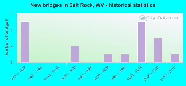
- New bridges - historical statistics
- 51920-1929
- 21950-1959
- 11970-1979
- 11980-1989
- 51990-1999
- 32000-2009
- 12010-2019


- Bridge Condition - Deck
- 29.4%Good
- 23.5%Satisfactory
- 23.5%Fair
- 23.5%Poor

- Bridge Condition - Superstructure
- 23.5%Good
- 35.3%Satisfactory
- 17.6%Fair
- 17.6%Poor
- 5.9%Serious

- Bridge Condition - Substructure
- 29.4%Good
- 29.4%Satisfactory
- 23.5%Fair
- 11.8%Poor
- 5.9%Serious

- Bridge Condition - Channel
- 33.3%Good
- 44.4%Satisfactory
- 11.1%Fair
- 11.1%Poor
Find on map >> Show street view
Structure Number: 6A024, Location: 0.05 MI SOUTH OF CR 31 (Lat: 38.323600, Lng: -82.211861), Route carried "on" structure: State highway 1000, Year Built: 1990, Status: Open, Structure Length: 1.26m (4.13ft), Average Daily Traffic: 3,500 (year 2017), Truck Traffic: 4%, Average Future Daily Traffic: 4,375 (year 2037), Design Load: HS 25 or greater, Features Intersected: TYLER CREEK, Facility Carried by Structure: WV 10
Minimum Vertical Clearance: 30+ m (98+ ft), Kilometerpoint: 1.529, Lanes on structure: 2, Base Highway Network: Yes, Owner: State Highway Agency, Approaching Roadway Width: 7.9m (25.9ft), Material/Design: Prestressed concrete, Design/Construction: Box Beam or Girders - Multiple, Number Of Spans In Main Unit: 1, Length of Maximum Span: 12.2m (40.0ft), Curb-To-Curb Width: 8.9m (29.2ft), Out-to-Out Width: 9.2m (30.2ft)
Condition: Deck: Satisfactory, Superstructure: Satisfactory, Substructure: Satisfactory, Channel: Satisfactory, Operating Rating: 88.9 metric tons, Method Used To Determine Operating Rating: Load Factor (LF), Inventory Rating: 53.5 metric tons, Method Used To Determine Inventory Rating: Load Factor (LF), Structural Evaluation: Equal to present minimum criteria, Deck Geometry: Meets minimum limits, Waterway Adequacy: Equal to present desirable criteria, Approach Roadway Alignment: Equal to present desirable criteria, Designated Inspection Frequency: Every 48 months, Inspection Date: August 2020, Deck Structure Type: Other, Wearing Surface/Protective System: Wearing Surface: Bituminous, Membrane: Epoxy
Find on map >> Show street view
Structure Number: 6A025, Location: 0.06 MI SOUTH OF CR 49 (Lat: 38.323011, Lng: -82.219569), Route carried "on" structure: State highway 1000, Year Built: 1974, Year Reconstructed: 2013, Status: Open, Structure Length: 11.12m (36.48ft), Average Daily Traffic: 2,700 (year 2020), Truck Traffic: 3%, Average Future Daily Traffic: 3,267 (year 2040), Design Load: HS 20, Features Intersected: GUYANDOTTE RIVER, Facility Carried by Structure: WV 10
Minimum Vertical Clearance: 30+ m (98+ ft), Kilometerpoint: 2.221, Lanes on structure: 2, Base Highway Network: Yes, Owner: State Highway Agency, Approaching Roadway Width: 15.2m (49.9ft), Skew: 2 degrees, Material/Design: Steel continuous, Design/Construction: Stringer/Multi-beam, Number Of Spans In Main Unit: 1, Number Of Approach Spans: 2, Length of Maximum Span: 45.1m (148.0ft), Curb or Sidewalk Widths: Left: 1.5m (4.9ft), Right: 0.0m, Curb-To-Curb Width: 13.0m (42.7ft), Out-to-Out Width: 15.8m (51.8ft)
Condition: Deck: Fair, Superstructure: Satisfactory, Substructure: Satisfactory, Channel: Good, Operating Rating: 65.3 metric tons, Method Used To Determine Operating Rating: Load Factor (LF), Inventory Rating: 39.0 metric tons, Method Used To Determine Inventory Rating: Load Factor (LF), Structural Evaluation: Equal to present minimum criteria, Deck Geometry: Equal to present minimum criteria, Waterway Adequacy: Equal to present minimum criteria, Approach Roadway Alignment: Better than present minimum criteria, Designated Inspection Frequency: Every 24 months, Inspection Date: December 2021, Deck Structure Type: Concrete Cast-file-Place, Wearing Surface/Protective System: Wearing Surface: Latex Concrete
Find on map >> Show street view
Structure Number: 6A026, Location: 0.05 MI NORTH OF CR 66 (Lat: 38.331981, Lng: -82.241119), Route carried "on" structure: State highway 1000, Year Built: 1950, Status: Open, Structure Length: 0.86m (2.82ft), Average Daily Traffic: 6,200 (year 2018), Truck Traffic: 7%, Average Future Daily Traffic: 7,875 (year 2038), Features Intersected: SMITH CREEK, Facility Carried by Structure: WV 10
Minimum Vertical Clearance: 30+ m (98+ ft), Kilometerpoint: 5.810, Lanes on structure: 2, Base Highway Network: Yes, Owner: State Highway Agency, Approaching Roadway Width: 10.7m (35.1ft), Material/Design: Concrete, Design/Construction: Slab, Number Of Spans In Main Unit: 1, Length of Maximum Span: 8.2m (26.9ft), Curb-To-Curb Width: 8.3m (27.2ft), Out-to-Out Width: 9.2m (30.2ft)
Condition: Deck: Fair, Superstructure: Fair, Substructure: Satisfactory, Channel: Satisfactory, Operating Rating: 53.5 metric tons, Method Used To Determine Operating Rating: Field evaluation and documented engineering judgment, Inventory Rating: 24.5 metric tons, Method Used To Determine Inventory Rating: Field evaluation and documented engineering judgment, Structural Evaluation: Somewhat better than minimum adequacy, Deck Geometry: High priority of replacement, Waterway Adequacy: Equal to present minimum criteria, Approach Roadway Alignment: Better than present minimum criteria, Length Of Structure Improvement: 0.91m (2.99ft), Designated Inspection Frequency: Every 24 months, Inspection Date: May 2020, Bridge Improvement Cost: $110,000, Roadway Improvement Cost: $40,000, Total Project Cost: $185,000 ( Estimate for 2018), Deck Structure Type: Concrete Cast-file-Place, Wearing Surface/Protective System: Wearing Surface: Bituminous
Find on map >> Show street view
Structure Number: 6A068, Location: 0.01 MI NORTH OF CR 47/1 (Lat: 38.349511, Lng: -82.182969), Route carried "on" structure: County highway 2900, Year Built: 1926, Status: Open, Structure Length: 0.98m (3.22ft), Average Daily Traffic: 300 (year 2016), Truck Traffic: 7%, Average Future Daily Traffic: 327 (year 2038), Features Intersected: TRACE CREEK, Facility Carried by Structure: CR 29
Minimum Vertical Clearance: 30+ m (98+ ft), Kilometerpoint: 2.704, Lanes on structure: 2, Owner: State Highway Agency, Approaching Roadway Width: 5.8m (19.0ft), Material/Design: Concrete, Design/Construction: Girder and Floorbeam System, Number Of Spans In Main Unit: 1, Length of Maximum Span: 9.5m (31.2ft), Curb or Sidewalk Widths: Left: 0.2m (0.7ft), Right: 0.2m (0.7ft), Curb-To-Curb Width: 5.8m (19.0ft), Out-to-Out Width: 6.9m (22.6ft)
Condition: Deck: Poor, Superstructure: Fair, Substructure: Fair, Channel: Satisfactory, Operating Rating: 47.2 metric tons, Method Used To Determine Operating Rating: Field evaluation and documented engineering judgment, Inventory Rating: 21.8 metric tons, Method Used To Determine Inventory Rating: Field evaluation and documented engineering judgment, Structural Evaluation: Somewhat better than minimum adequacy, Deck Geometry: High priority of corrective action, Waterway Adequacy: Somewhat better than minimum adequacy, Approach Roadway Alignment: Meets minimum limits, Length Of Structure Improvement: 0.98m (3.22ft), Designated Inspection Frequency: Every 24 months, Inspection Date: September 2020, Bridge Improvement Cost: $90,000, Roadway Improvement Cost: $20,000, Total Project Cost: $145,000 ( Estimate for 2018), Deck Structure Type: Concrete Cast-file-Place, Wearing Surface/Protective System: Wearing Surface: Bituminous
Find on map >> Show street view
Structure Number: 6A078, Location: 0.05 MI EAST OF CO 45 (Lat: 38.358200, Lng: -82.223200), Route carried "on" structure: County highway 3100, Year Built: 1923, Status: Posted for load, Structure Length: 3.05m (10.01ft), Average Daily Traffic: 400 (year 2020), Truck Traffic: 8%, Average Future Daily Traffic: 484 (year 2040), Features Intersected: CAVILL CREEK, Facility Carried by Structure: COUNTY ROUTE 31
Minimum Vertical Clearance: 30+ m (98+ ft), Kilometerpoint: 12.295, Lanes on structure: 2, Owner: State Highway Agency, Approaching Roadway Width: 7.0m (23.0ft), Material/Design: Concrete, Design/Construction: Tee Beam, Number Of Spans In Main Unit: 1, Number Of Approach Spans: 1, Length of Maximum Span: 15.1m (49.5ft), Curb-To-Curb Width: 5.6m (18.4ft), Out-to-Out Width: 6.4m (21.0ft)
Condition: Deck: Poor, Superstructure: Serious, Substructure: Serious, Channel: Poor, Operating Rating: 24.5 metric tons, Method Used To Determine Operating Rating: Field evaluation and documented engineering judgment, Inventory Rating: 10.0 metric tons, Method Used To Determine Inventory Rating: Field evaluation and documented engineering judgment, Structural Evaluation: High priority of replacement, Deck Geometry: High priority of corrective action, Waterway Adequacy: Equal to present minimum criteria, Approach Roadway Alignment: Equal to present minimum criteria, Bridge Posting: Required (Relationship of Operating Rating to Maximum Legal Load: 10.0 - 19.9% below), Length Of Structure Improvement: 3.05m (10.01ft), Designated Inspection Frequency: Every 24 months, Other Special Inspection Frequency: Every 6 months, Inspection Date: December 2021, Other Special Inspection Date: December 2021, Bridge Improvement Cost: $270,000, Roadway Improvement Cost: $100,000, Total Project Cost: $462,000 ( Estimate for 2018), Deck Structure Type: Concrete Cast-file-Place, Wearing Surface/Protective System: Wearing Surface: Bituminous
Find on map >> Show street view
Structure Number: 6A079, Location: 0.32 MI W OF CR 56 (Lat: 38.347769, Lng: -82.216561), Route carried "on" structure: County highway 3100, Year Built: 1923, Status: Posted for load, Structure Length: 3.08m (10.10ft), Average Daily Traffic: 2,200 (year 2018), Truck Traffic: 7%, Average Future Daily Traffic: 2,794 (year 2038), Features Intersected: TOM CREEK, Facility Carried by Structure: CR 31
Minimum Vertical Clearance: 30+ m (98+ ft), Kilometerpoint: 13.744, Lanes on structure: 2, Owner: State Highway Agency, Approaching Roadway Width: 7.6m (24.9ft), Material/Design: Concrete continuous, Design/Construction: Tee Beam, Number Of Spans In Main Unit: 1, Number Of Approach Spans: 1, Length of Maximum Span: 15.3m (50.2ft), Curb or Sidewalk Widths: Left: 0.2m (0.7ft), Right: 0.2m (0.7ft), Curb-To-Curb Width: 5.5m (18.0ft), Out-to-Out Width: 6.4m (21.0ft)
Condition: Deck: Poor, Superstructure: Poor, Substructure: Poor, Channel: Satisfactory, Operating Rating: 49.0 metric tons, Method Used To Determine Operating Rating: Field evaluation and documented engineering judgment, Inventory Rating: 20.9 metric tons, Method Used To Determine Inventory Rating: Field evaluation and documented engineering judgment, Structural Evaluation: Meets minimum limits, Waterway Adequacy: Equal to present minimum criteria, Approach Roadway Alignment: Meets minimum limits, Bridge Posting: Required (Relationship of Operating Rating to Maximum Legal Load: 10.0 - 19.9% below), Length Of Structure Improvement: 3.35m (10.99ft), Designated Inspection Frequency: Every 24 months, Inspection Date: June 2020, Bridge Improvement Cost: $308,000, Roadway Improvement Cost: $50,000, Total Project Cost: $443,000 ( Estimate for 2018), Deck Structure Type: Concrete Cast-file-Place, Wearing Surface/Protective System: Wearing Surface: Bituminous
Find on map >> Show street view
Structure Number: 6A08, Location: 0.04 MI EAST OF CO 31/5 (Lat: 38.336500, Lng: -82.208239), Route carried "on" structure: County highway 3100, Year Built: 1923, Status: Posted for load, Structure Length: 3.07m (10.07ft), Average Daily Traffic: 438 (year 2019), Truck Traffic: 4%, Average Future Daily Traffic: 473 (year 2038), Features Intersected: TRACE CREEK, Facility Carried by Structure: CO 31
Minimum Vertical Clearance: 30+ m (98+ ft), Kilometerpoint: 15.595, Lanes on structure: 2, Owner: State Highway Agency, Approaching Roadway Width: 7.3m (24.0ft), Material/Design: Concrete continuous, Design/Construction: Tee Beam, Number Of Spans In Main Unit: 1, Number Of Approach Spans: 1, Length of Maximum Span: 15.1m (49.5ft), Curb or Sidewalk Widths: Left: 0.2m (0.7ft), Right: 0.2m (0.7ft), Curb-To-Curb Width: 5.4m (17.7ft), Out-to-Out Width: 6.4m (21.0ft)
Condition: Deck: Poor, Superstructure: Poor, Substructure: Poor, Channel: Fair, Operating Rating: 41.7 metric tons, Method Used To Determine Operating Rating: Field evaluation and documented engineering judgment, Inventory Rating: 17.2 metric tons, Method Used To Determine Inventory Rating: Field evaluation and documented engineering judgment, Structural Evaluation: Meets minimum limits, Deck Geometry: High priority of replacement, Waterway Adequacy: Equal to present minimum criteria, Approach Roadway Alignment: Meets minimum limits, Length Of Structure Improvement: 3.96m (12.99ft), Designated Inspection Frequency: Every 24 months, Other Special Inspection Frequency: Every 12 months, Inspection Date: June 2020, Other Special Inspection Date: June 2021, Bridge Improvement Cost: $302,000, Roadway Improvement Cost: $294,000, Total Project Cost: $806,000 ( Estimate for 2018), Deck Structure Type: Concrete Cast-file-Place, Wearing Surface/Protective System: Wearing Surface: Bituminous
Find on map >> Show street view
Structure Number: 6A11, Location: 0.05 MI EAST OF CR 49/4 (Lat: 38.298669, Lng: -82.213739), Route carried "on" structure: County highway 4900, Year Built: 1990, Status: Open, Structure Length: 1.51m (4.95ft), Average Daily Traffic: 250 (year 2020), Truck Traffic: 8%, Average Future Daily Traffic: 303 (year 2040), Design Load: HS 25 or greater, Features Intersected: MADISON CREEK, Facility Carried by Structure: CR 49
Minimum Vertical Clearance: 30+ m (98+ ft), Kilometerpoint: 11.925, Lanes on structure: 2, Owner: State Highway Agency, Approaching Roadway Width: 5.5m (18.0ft), Material/Design: Prestressed concrete, Design/Construction: Box Beam or Girders - Multiple, Number Of Spans In Main Unit: 1, Length of Maximum Span: 14.6m (47.9ft), Curb-To-Curb Width: 7.0m (23.0ft), Out-to-Out Width: 7.3m (24.0ft)
Condition: Deck: Good, Superstructure: Good, Substructure: Good, Channel: Good, Operating Rating: 88.9 metric tons, Method Used To Determine Operating Rating: Load Factor (LF), Inventory Rating: 58.0 metric tons, Method Used To Determine Inventory Rating: Load Factor (LF), Structural Evaluation: Better than present minimum criteria, Deck Geometry: Meets minimum limits, Waterway Adequacy: Equal to present minimum criteria, Approach Roadway Alignment: Better than present minimum criteria, Designated Inspection Frequency: Every 48 months, Inspection Date: October 2021, Deck Structure Type: Other, Wearing Surface/Protective System: Wearing Surface: Bituminous, Deck Protection: Epoxy Coated Reinforcing
Find on map >> Show street view
Structure Number: 6A13, Location: 0.05 MI EAST OF WV 10 (Lat: 38.333139, Lng: -82.271300), Route carried "on" structure: County highway 6900, Year Built: 1926, Status: Open, Structure Length: 0.91m (2.99ft), Average Daily Traffic: 250 (year 2020), Truck Traffic: 8%, Average Future Daily Traffic: 303 (year 2040), Features Intersected: RIGHT FK MERRITT CK, Facility Carried by Structure: CR 69
Minimum Vertical Clearance: 30+ m (98+ ft), Kilometerpoint: 0.080, Lanes on structure: 2, Owner: State Highway Agency, Approaching Roadway Width: 5.8m (19.0ft), Skew: 2 degrees, Material/Design: Concrete, Design/Construction: Girder and Floorbeam System, Number Of Spans In Main Unit: 1, Length of Maximum Span: 8.9m (29.2ft), Curb or Sidewalk Widths: Left: 0.2m (0.7ft), Right: 0.2m (0.7ft), Curb-To-Curb Width: 5.5m (18.0ft), Out-to-Out Width: 6.6m (21.7ft)
Condition: Deck: Fair, Superstructure: Satisfactory, Substructure: Fair, Channel: Fair, Operating Rating: 47.2 metric tons, Method Used To Determine Operating Rating: Field evaluation and documented engineering judgment, Inventory Rating: 21.8 metric tons, Method Used To Determine Inventory Rating: Field evaluation and documented engineering judgment, Structural Evaluation: Somewhat better than minimum adequacy, Deck Geometry: High priority of corrective action, Waterway Adequacy: Better than present minimum criteria, Approach Roadway Alignment: Equal to present minimum criteria, Length Of Structure Improvement: 0.98m (3.22ft), Designated Inspection Frequency: Every 24 months, Inspection Date: November 2021, Bridge Improvement Cost: $90,000, Roadway Improvement Cost: $20,000, Total Project Cost: $145,000 ( Estimate for 2018), Deck Structure Type: Concrete Cast-file-Place, Wearing Surface/Protective System: Wearing Surface: Bituminous
Find on map >> Show street view
Structure Number: 6A16, Location: 1.16 MI SOUTH OF WV 10 (Lat: 38.319931, Lng: -82.241931), Route carried "on" structure: County highway 6600, Year Built: 1991, Status: Open, Structure Length: 1.20m (3.94ft), Average Daily Traffic: 400 (year 2018), Truck Traffic: 7%, Average Future Daily Traffic: 508 (year 2038), Features Intersected: SMITH CREEK, Facility Carried by Structure: CR 66
Minimum Vertical Clearance: 30+ m (98+ ft), Kilometerpoint: 4.748, Lanes on structure: 2, Owner: State Highway Agency, Approaching Roadway Width: 4.9m (16.1ft), Skew: 3 degrees, Material/Design: Prestressed concrete, Design/Construction: Box Beam or Girders - Multiple, Number Of Spans In Main Unit: 1, Length of Maximum Span: 11.6m (38.1ft), Curb-To-Curb Width: 6.1m (20.0ft), Out-to-Out Width: 6.4m (21.0ft)
Condition: Deck: Satisfactory, Superstructure: Satisfactory, Substructure: Good, Channel: Satisfactory, Operating Rating: 88.9 metric tons, Method Used To Determine Operating Rating: Load Factor (LF), Inventory Rating: 55.3 metric tons, Method Used To Determine Inventory Rating: Load Factor (LF), Structural Evaluation: Equal to present minimum criteria, Deck Geometry: Meets minimum limits, Waterway Adequacy: Equal to present minimum criteria, Approach Roadway Alignment: Better than present minimum criteria, Designated Inspection Frequency: Every 24 months, Inspection Date: October 2020, Deck Structure Type: Other, Wearing Surface/Protective System: Wearing Surface: Bituminous, Deck Protection: Epoxy Coated Reinforcing
Find on map >> Show street view
Structure Number: 6A161, Location: 0.83 MI SOUTH OF WV 10 (Lat: 38.323389, Lng: -82.237831), Route carried "on" structure: County highway 6600, Year Built: 1988, Status: Open, Structure Length: 0.79m (2.59ft), Average Daily Traffic: 450 (year 2015), Truck Traffic: 7%, Average Future Daily Traffic: 572 (year 2035), Design Load: HS 25 or greater, Features Intersected: SMITH CREEK, Facility Carried by Structure: CR 66
Minimum Vertical Clearance: 30+ m (98+ ft), Kilometerpoint: 5.279, Lanes on structure: 2, Owner: State Highway Agency, Approaching Roadway Width: 7.3m (24.0ft), Skew: 4 degrees, Material/Design: Prestressed concrete, Design/Construction: Box Beam or Girders - Multiple, Number Of Spans In Main Unit: 1, Length of Maximum Span: 7.5m (24.6ft), Curb-To-Curb Width: 7.1m (23.3ft), Out-to-Out Width: 7.4m (24.3ft)
Condition: Deck: Good, Superstructure: Satisfactory, Substructure: Satisfactory, Channel: Satisfactory, Operating Rating: 88.9 metric tons, Method Used To Determine Operating Rating: Load Factor (LF), Inventory Rating: 69.8 metric tons, Method Used To Determine Inventory Rating: Load Factor (LF), Structural Evaluation: Equal to present minimum criteria, Deck Geometry: Meets minimum limits, Waterway Adequacy: Equal to present minimum criteria, Approach Roadway Alignment: Equal to present minimum criteria, Designated Inspection Frequency: Every 48 months, Inspection Date: January 2018, Deck Structure Type: Other, Wearing Surface/Protective System: Wearing Surface: Bituminous, Deck Protection: Epoxy Coated Reinforcing
Find on map >> Show street view
Structure Number: 6A162, Location: 0.03 MI WEST OF WV 10 (Lat: 38.329950, Lng: -82.258069), Route carried "on" structure: County highway 6800, Year Built: 1950, Status: Open, Structure Length: 0.92m (3.02ft), Average Daily Traffic: 300 (year 2018), Truck Traffic: 7%, Average Future Daily Traffic: 381 (year 2038), Features Intersected: MERRITT CREEK, Facility Carried by Structure: CR 68
Minimum Vertical Clearance: 30+ m (98+ ft), Kilometerpoint: 0.048, Lanes on structure: 2, Owner: State Highway Agency, Approaching Roadway Width: 6.1m (20.0ft), Skew: 3 degrees, Material/Design: Concrete, Design/Construction: Slab, Number Of Spans In Main Unit: 1, Length of Maximum Span: 8.8m (28.9ft), Curb or Sidewalk Widths: Left: 0.2m (0.7ft), Right: 0.2m (0.7ft), Curb-To-Curb Width: 5.5m (18.0ft), Out-to-Out Width: 6.6m (21.7ft)
Condition: Deck: Fair, Superstructure: Fair, Substructure: Fair, Channel: Poor, Operating Rating: 53.5 metric tons, Method Used To Determine Operating Rating: Field evaluation and documented engineering judgment, Inventory Rating: 24.5 metric tons, Method Used To Determine Inventory Rating: Field evaluation and documented engineering judgment, Structural Evaluation: Somewhat better than minimum adequacy, Deck Geometry: High priority of corrective action, Waterway Adequacy: Somewhat better than minimum adequacy, Approach Roadway Alignment: Equal to present minimum criteria, Length Of Structure Improvement: 0.98m (3.22ft), Designated Inspection Frequency: Every 24 months, Inspection Date: Febuary 2020, Bridge Improvement Cost: $90,000, Roadway Improvement Cost: $20,000, Total Project Cost: $145,000 ( Estimate for 2018), Deck Structure Type: Concrete Cast-file-Place, Wearing Surface/Protective System: Wearing Surface: Bituminous
Find on map >> Show street view
Structure Number: 6A239, Location: 0.25 MILE WEST OF CR 49/3 (Lat: 38.310400, Lng: -82.220761), Route carried "on" structure: County highway 4900, Year Built: 1997, Status: Open, Structure Length: 3.28m (10.76ft), Average Daily Traffic: 3,400 (year 2019), Truck Traffic: 8%, Average Future Daily Traffic: 4,114 (year 2039), Design Load: HS 25 or greater, Features Intersected: MADISON CREEK, Facility Carried by Structure: CR 49
Minimum Vertical Clearance: 30+ m (98+ ft), Kilometerpoint: 13.696, Lanes on structure: 2, Owner: State Highway Agency, Approaching Roadway Width: 10.1m (33.1ft), Skew: 3 degrees, Material/Design: Prestressed concrete, Design/Construction: Box Beam or Girders - Multiple, Number Of Spans In Main Unit: 1, Length of Maximum Span: 32.3m (106.0ft), Curb-To-Curb Width: 9.5m (31.2ft), Out-to-Out Width: 9.8m (32.2ft)
Condition: Deck: Satisfactory, Superstructure: Poor, Substructure: Fair, Channel: Good, Operating Rating: 74.4 metric tons, Method Used To Determine Operating Rating: Load Factor (LF), Inventory Rating: 41.7 metric tons, Method Used To Determine Inventory Rating: Load Factor (LF), Structural Evaluation: Meets minimum limits, Deck Geometry: Meets minimum limits, Waterway Adequacy: Equal to present minimum criteria, Approach Roadway Alignment: Equal to present minimum criteria, Designated Inspection Frequency: Every 24 months, Other Special Inspection Frequency: Every 12 months, Inspection Date: June 2021, Other Special Inspection Date: June 2021, Deck Structure Type: Other, Wearing Surface/Protective System: Wearing Surface: Bituminous, Membrane: Epoxy, Deck Protection: Epoxy Coated Reinforcing
Find on map >> Show street view
Structure Number: 6A256, Location: 0.05 MILE WEST OF CR 31 (Lat: 38.360689, Lng: -82.224319), Route carried "on" structure: County highway 4500, Year Built: 2000, Status: Open, Structure Length: 12.92m (42.39ft), Average Daily Traffic: 1,940 (year 2019), Truck Traffic: 7%, Average Future Daily Traffic: 2,464 (year 2039), Design Load: HS 25 or greater, Features Intersected: GUYANDOTTE RIVER, Facility Carried by Structure: CR 45
Minimum Vertical Clearance: 30+ m (98+ ft), Kilometerpoint: 3.299, Lanes on structure: 2, Owner: State Highway Agency, Approaching Roadway Width: 12.2m (40.0ft), Material/Design: Prestressed concrete, Design/Construction: Stringer/Multi-beam, Number Of Spans In Main Unit: 1, Number Of Approach Spans: 3, Length of Maximum Span: 32.4m (106.3ft), Curb or Sidewalk Widths: Left: 0.0m, Right: 1.5m (4.9ft), Curb-To-Curb Width: 8.6m (28.2ft), Out-to-Out Width: 10.9m (35.8ft)
Condition: Deck: Satisfactory, Superstructure: Satisfactory, Substructure: Satisfactory, Channel: Good, Operating Rating: 74.4 metric tons, Method Used To Determine Operating Rating: Load Factor (LF), Inventory Rating: 44.4 metric tons, Method Used To Determine Inventory Rating: Load Factor (LF), Structural Evaluation: Equal to present minimum criteria, Deck Geometry: Somewhat better than minimum adequacy, Waterway Adequacy: Better than present minimum criteria, Approach Roadway Alignment: Better than present minimum criteria, Designated Inspection Frequency: Every 24 months, Inspection Date: November 2020, Deck Structure Type: Concrete Cast-file-Place, Wearing Surface/Protective System: Wearing Surface: Integral Concrete, Deck Protection: Epoxy Coated Reinforcing
Find on map >> Show street view
Structure Number: 6A283, Location: 0.01 MILES N OF CO 10/5 (Lat: 38.334811, Lng: -82.263989), Route carried "on" structure: State highway 1000, Year Built: 2007, Status: Open, Structure Length: 2.39m (7.84ft), Average Daily Traffic: 4,300 (year 2020), Truck Traffic: 3%, Average Future Daily Traffic: 5,203 (year 2040), Design Load: HL 93, Features Intersected: MERRITT CREEK, Facility Carried by Structure: WEST VIRGINIA 10
Minimum Vertical Clearance: 30+ m (98+ ft), Kilometerpoint: 8.031, Lanes on structure: 2, Owner: State Highway Agency, Approaching Roadway Width: 9.4m (30.8ft), Material/Design: Prestressed concrete, Design/Construction: Stringer/Multi-beam, Number Of Spans In Main Unit: 1, Length of Maximum Span: 23.2m (76.1ft), Curb or Sidewalk Widths: Left: 0.4m (1.3ft), Right: 0.4m (1.3ft), Curb-To-Curb Width: 9.8m (32.2ft), Out-to-Out Width: 10.5m (34.4ft)
Condition: Deck: Good, Superstructure: Good, Substructure: Good, Channel: Good, Operating Rating: 70.7 metric tons, Method Used To Determine Operating Rating: Load and Resistance Factor (LRFR), Inventory Rating: 54.4 metric tons, Method Used To Determine Inventory Rating: Load and Resistance Factor (LRFR), Structural Evaluation: Better than present minimum criteria, Deck Geometry: Meets minimum limits, Waterway Adequacy: Meets minimum limits, Approach Roadway Alignment: Somewhat better than minimum adequacy, Designated Inspection Frequency: Every 48 months, Inspection Date: December 2021, Deck Structure Type: Concrete Cast-file-Place, Wearing Surface/Protective System: Wearing Surface: Monolithic Concrete, Deck Protection: Epoxy Coated Reinforcing
Find on map >> Show street view
Structure Number: 6A292, Location: 0.05 MILES N OF C R 10/5 (Lat: 38.338019, Lng: -82.263981), Route carried "on" structure: County highway 1038, Year Built: 2010, Status: Open, Structure Length: 1.27m (4.17ft), Average Daily Traffic: 10 (year 2016), Truck Traffic: 7%, Average Future Daily Traffic: 12 (year 2036), Design Load: HL 93, Features Intersected: MERRITT CREEK, Facility Carried by Structure: COUNTY ROUTE 10/38
Minimum Vertical Clearance: 30+ m (98+ ft), Kilometerpoint: 0.080, Lanes on structure: 2, Owner: State Highway Agency, Approaching Roadway Width: 6.1m (20.0ft), Skew: 3 degrees, Material/Design: Prestressed concrete, Design/Construction: Box Beam or Girders - Multiple, Number Of Spans In Main Unit: 1, Length of Maximum Span: 12.2m (40.0ft), Curb-To-Curb Width: 5.5m (18.0ft), Out-to-Out Width: 5.5m (18.0ft)
Condition: Deck: Good, Superstructure: Good, Substructure: Good, Channel: Satisfactory, Operating Rating: 68.0 metric tons, Method Used To Determine Operating Rating: Load and Resistance Factor (LRFR), Inventory Rating: 52.6 metric tons, Method Used To Determine Inventory Rating: Load and Resistance Factor (LRFR), Structural Evaluation: Better than present minimum criteria, Deck Geometry: Meets minimum limits, Waterway Adequacy: Meets minimum limits, Approach Roadway Alignment: Better than present minimum criteria, Designated Inspection Frequency: Every 24 months, Inspection Date: Febuary 2020, Deck Structure Type: Other, Wearing Surface/Protective System: Wearing Surface: Monolithic Concrete, Deck Protection: Epoxy Coated Reinforcing
Find on map >> Show street view
Structure Number: 22A039, Location: 0.14 MI SOUTH OF CR 6 (Lat: 38.314061, Lng: -82.190711), Route carried "on" structure: State highway 1000, Year Built: 1990, Status: Open, Structure Length: 1.51m (4.95ft), Average Daily Traffic: 2,598 (year 2019), Truck Traffic: 6%, Average Future Daily Traffic: 2,751 (year 2039), Design Load: HS 25 or greater, Features Intersected: BEAR CREEK, Facility Carried by Structure: WV 10
Minimum Vertical Clearance: 30+ m (98+ ft), Kilometerpoint: 49.745, Lanes on structure: 2, Base Highway Network: Yes, Owner: State Highway Agency, Approaching Roadway Width: 8.5m (27.9ft), Material/Design: Prestressed concrete, Design/Construction: Box Beam or Girders - Multiple, Number Of Spans In Main Unit: 1, Length of Maximum Span: 14.6m (47.9ft), Curb-To-Curb Width: 8.9m (29.2ft), Out-to-Out Width: 9.2m (30.2ft)
Condition: Deck: Good, Superstructure: Good, Substructure: Good, Channel: Good, Operating Rating: 88.9 metric tons, Method Used To Determine Operating Rating: Load Factor (LF), Inventory Rating: 55.3 metric tons, Method Used To Determine Inventory Rating: Load Factor (LF), Structural Evaluation: Better than present minimum criteria, Deck Geometry: Meets minimum limits, Waterway Adequacy: Equal to present minimum criteria, Approach Roadway Alignment: Better than present minimum criteria, Designated Inspection Frequency: Every 24 months, Inspection Date: April 2021, Deck Structure Type: Other, Wearing Surface/Protective System: Wearing Surface: Monolithic Concrete, Deck Protection: Epoxy Coated Reinforcing
Find on map >> Show street view
Structure Number: 22A15, Location: 0.65 MILES NORTH OF WV 10 (Lat: 38.306489, Lng: -82.199311), Route carried "on" structure: County highway 1017, Year Built: 2004, Status: Open, Structure Length: 0.62m (2.03ft), Average Daily Traffic: 50 (year 2018), Average Future Daily Traffic: 50 (year 2038), Design Load: HS 20, Features Intersected: BEAR CREEK, Facility Carried by Structure: COUNTY ROUTE 10/17
Minimum Vertical Clearance: 30+ m (98+ ft), Kilometerpoint: 1.046, Lanes on structure: 1, Owner: State Highway Agency, Approaching Roadway Width: 3.4m (11.2ft), Material/Design: Aluminum, Iron, Design/Construction: Culvert, Number Of Spans In Main Unit: 1, Length of Maximum Span: 6.2m (20.3ft), Out-to-Out Width: 5.6m (18.4ft)
Condition: Channel: Satisfactory, Culverts: Good, Operating Rating: 71.7 metric tons, Method Used To Determine Operating Rating: Field evaluation and documented engineering judgment, Inventory Rating: 32.7 metric tons, Method Used To Determine Inventory Rating: Field evaluation and documented engineering judgment, Structural Evaluation: Better than present minimum criteria, Waterway Adequacy: Equal to present minimum criteria, Approach Roadway Alignment: Equal to present minimum criteria, Designated Inspection Frequency: Every 24 months, Inspection Date: Febuary 2020