Bridge Statistics for Rosemead, California (CA)
Condition, Traffic, Stress, Structural Evaluation, Project Costs
- National Bridge Inventory (NBI) Statistics
- 47Number of bridges
- 344ft / 105mTotal length
- $813,000Total costs
- 2,481,460Total average daily traffic
- 129,993Total average daily truck traffic
- National Bridge Inventory (NBI) Registered Bridges for Rosemead
- No street view available for this location
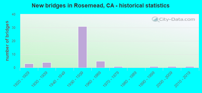
- New bridges - historical statistics
- 31920-1929
- 41930-1939
- 311950-1959
- 51960-1969
- 11970-1979
- 11990-1999
- 12000-2009
- 12010-2019
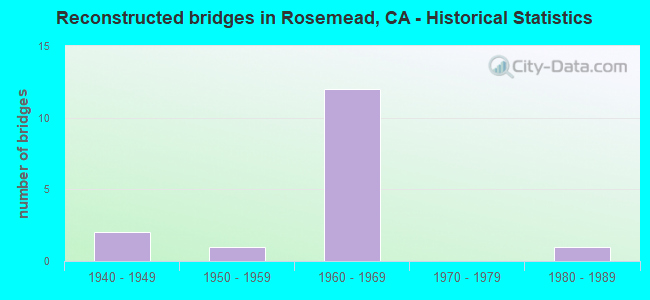
- Reconstructed bridges - Historical Statistics
- 21940-1949
- 11950-1959
- 121960-1969
- 01970-1979
- 11980-1989
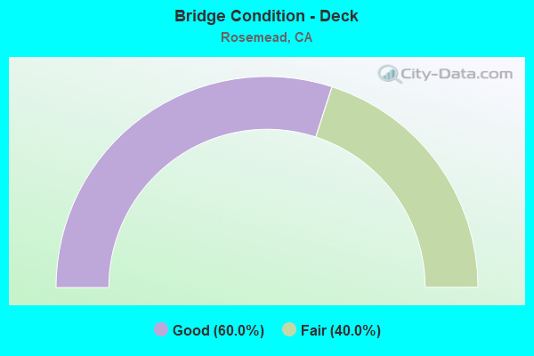
- Bridge Condition - Deck
- 60.0%Good
- 40.0%Fair
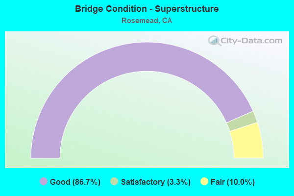
- Bridge Condition - Superstructure
- 86.7%Good
- 3.3%Satisfactory
- 10.0%Fair
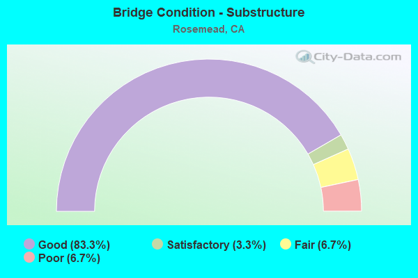
- Bridge Condition - Substructure
- 83.3%Good
- 3.3%Satisfactory
- 6.7%Fair
- 6.7%Poor
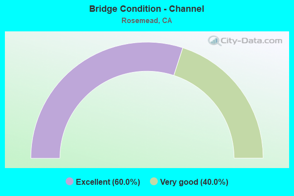
- Bridge Condition - Channel
- 60.0%Excellent
- 40.0%Very good
Find on map >> Show street view
Structure Number: 53 0010K, Location: 07-LA-010-26.84-RSMD (Lat: 34.072592, Lng: -118.073311), Route carried "on" structure: Ramp Interstate 10, Year Built: 1951, Status: Open, Structure Length: 5.30m (17.39ft), Average Daily Traffic: 13,500 (year 2011), Truck Traffic: 2%, Average Future Daily Traffic: 16,944 (year 2041), Design Load: HS 20, Features Intersected: SR 164 (ROSEMEAD BL)
Minimum Vertical Clearance: 30+ m (98+ ft), Kilometerpoint: 26.840, Lanes on structure: 2, Lanes under structure: 6, Owner: State Highway Agency, Approaching Roadway Width: 10.0m (32.8ft), Material/Design: Concrete continuous, Design/Construction: Slab, Number Of Spans In Main Unit: 4, Length of Maximum Span: 15.8m (51.8ft), Curb or Sidewalk Widths: Left: 0.6m (2.0ft), Right: 1.2m (3.9ft), Curb-To-Curb Width: 10.0m (32.8ft), Out-to-Out Width: 10.8m (35.4ft)
Condition: Deck: Good, Superstructure: Good, Substructure: Good, Operating Rating: 54.1 metric tons, Method Used To Determine Operating Rating: Load Factor (LF), Inventory Rating: 32.4 metric tons, Method Used To Determine Inventory Rating: Load Factor (LF), Structural Evaluation: Better than present minimum criteria, Deck Geometry: Equal to present minimum criteria, Underclear: Meets minimum limits, Approach Roadway Alignment: Superior to present desirable criteria, Designated Inspection Frequency: Every 48 months, Inspection Date: Febuary 2019, Deck Structure Type: Concrete Cast-file-Place
Find on map >> Show street view
Structure Number: 53 0010L, Location: 07-LA-010-26.84-RSMD (Lat: 34.072358, Lng: -118.073331), Route carried "on" structure: Interstate 10, Year Built: 1953, Year Reconstructed: 1972, Status: Open, Structure Length: 5.55m (18.21ft), Average Daily Traffic: 107,500 (year 2012), Truck Traffic: 6%, Average Future Daily Traffic: 132,771 (year 2041), Design Load: HS 20, Features Intersected: SR 164 (ROSEMEAD BL)
Minimum Vertical Clearance: 30+ m (98+ ft), Kilometerpoint: 26.840, Lanes on structure: 6, Lanes under structure: 6, Base Highway Network: Yes (, Subroute: 1), Owner: State Highway Agency, Approaching Roadway Width: 23.8m (78.1ft), Material/Design: Concrete continuous, Design/Construction: Slab, Number Of Spans In Main Unit: 4, Length of Maximum Span: 25.9m (85.0ft), Curb or Sidewalk Widths: Left: 0.6m (2.0ft), Right: 0.0m, Curb-To-Curb Width: 23.8m (78.1ft), Out-to-Out Width: 24.6m (80.7ft)
Condition: Deck: Good, Superstructure: Good, Substructure: Good, Operating Rating: 99.8 metric tons, Method Used To Determine Operating Rating: Load Factor (LF), Inventory Rating: 61.6 metric tons, Method Used To Determine Inventory Rating: Load Factor (LF), Structural Evaluation: Better than present minimum criteria, Deck Geometry: High priority of corrective action, Underclear: Meets minimum limits, Approach Roadway Alignment: Equal to present desirable criteria, Designated Inspection Frequency: Every 48 months, Inspection Date: Febuary 2021, Deck Structure Type: Concrete Cast-file-Place
Find on map >> Show street view
Structure Number: 53 0010R, Location: 07-LA-010-26.84-RSMD (Lat: 34.072011, Lng: -118.073325), Route carried "on" structure: Interstate 10, Year Built: 1953, Year Reconstructed: 1972, Status: Open, Structure Length: 5.55m (18.21ft), Average Daily Traffic: 107,500 (year 2012), Truck Traffic: 6%, Average Future Daily Traffic: 132,771 (year 2041), Design Load: HS 20, Features Intersected: SR 164 (ROSEMEAD BL)
Minimum Vertical Clearance: 30+ m (98+ ft), Kilometerpoint: 26.840, Lanes on structure: 6, Lanes under structure: 6, Base Highway Network: Yes (, Subroute: 1), Owner: State Highway Agency, Approaching Roadway Width: 23.6m (77.4ft), Skew: 20 degrees, Material/Design: Concrete continuous, Design/Construction: Slab, Number Of Spans In Main Unit: 4, Length of Maximum Span: 25.9m (85.0ft), Curb or Sidewalk Widths: Left: 0.0m, Right: 0.6m (2.0ft), Curb-To-Curb Width: 23.6m (77.4ft), Out-to-Out Width: 24.4m (80.1ft)
Condition: Deck: Good, Superstructure: Good, Substructure: Good, Operating Rating: 82.5 metric tons, Method Used To Determine Operating Rating: Load Factor (LF), Inventory Rating: 49.9 metric tons, Method Used To Determine Inventory Rating: Load Factor (LF), Structural Evaluation: Better than present minimum criteria, Deck Geometry: High priority of replacement, Underclear: Meets minimum limits, Approach Roadway Alignment: Superior to present desirable criteria, Designated Inspection Frequency: Every 48 months, Inspection Date: Febuary 2021, Deck Structure Type: Concrete Cast-file-Place
Find on map >> Show street view
Structure Number: 53 0010S, Location: 07-LA-010-26.84-RSMD (Lat: 34.071722, Lng: -118.073342), Route carried "on" structure: Ramp Interstate 10, Year Built: 1951, Status: Open, Structure Length: 5.88m (19.29ft), Average Daily Traffic: 16,300 (year 2011), Truck Traffic: 2%, Average Future Daily Traffic: 13,298 (year 2041), Design Load: HS 20, Features Intersected: SR 164 (ROSEMEAD BL)
Minimum Vertical Clearance: 30+ m (98+ ft), Kilometerpoint: 26.840, Lanes on structure: 2, Lanes under structure: 6, Owner: State Highway Agency, Approaching Roadway Width: 10.0m (32.8ft), Material/Design: Concrete continuous, Design/Construction: Slab, Number Of Spans In Main Unit: 4, Length of Maximum Span: 18.9m (62.0ft), Curb or Sidewalk Widths: Left: 0.6m (2.0ft), Right: 1.2m (3.9ft), Curb-To-Curb Width: 10.0m (32.8ft), Out-to-Out Width: 10.8m (35.4ft)
Condition: Deck: Good, Superstructure: Good, Substructure: Good, Operating Rating: 39.5 metric tons, Method Used To Determine Operating Rating: Load and Resistance Factor Rating (LRFR) rating reported by rating factor(RF) method using HL-93 loadings, Inventory Rating: 30.5 metric tons, Method Used To Determine Inventory Rating: Load and Resistance Factor Rating (LRFR) rating reported by rating factor(RF) method using HL-93 loadings, Structural Evaluation: Better than present minimum criteria, Deck Geometry: Equal to present minimum criteria, Underclear: Meets minimum limits, Approach Roadway Alignment: Superior to present desirable criteria, Designated Inspection Frequency: Every 24 months, Inspection Date: Febuary 2021, Deck Structure Type: Concrete Cast-file-Place
Find on map >> Show street view
Structure Number: 53 0235, Location: 07-LA-164-4.91-EMTE (Lat: 34.063831, Lng: -118.066061), Route carried "on" structure: State highway 164, Year Built: 1937, Year Reconstructed: 1951, Status: Open, Structure Length: 12.62m (41.40ft), Average Daily Traffic: 44,100 (year 2021), Truck Traffic: 4%, Average Future Daily Traffic: 57,524 (year 2043), Design Load: H 15, Features Intersected: RIO HONDO
Minimum Vertical Clearance: 30+ m (98+ ft), Kilometerpoint: 4.910, Lanes on structure: 6, Base Highway Network: Yes (Inventory Route: 1, Subroute: 1), Owner: State Highway Agency, Approaching Roadway Width: 24.7m (81.0ft), Skew: 20 degrees, Material/Design: Concrete continuous, Design/Construction: Tee Beam, Number Of Spans In Main Unit: 9, Length of Maximum Span: 14.6m (47.9ft), Curb or Sidewalk Widths: Left: 1.2m (3.9ft), Right: 1.2m (3.9ft), Curb-To-Curb Width: 23.2m (76.1ft), Out-to-Out Width: 28.0m (91.9ft)
Condition: Deck: Fair, Superstructure: Good, Substructure: Good, Channel: Very good, Operating Rating: 40.1 metric tons, Method Used To Determine Operating Rating: Load Factor (LF), Inventory Rating: 24.3 metric tons, Method Used To Determine Inventory Rating: Load Factor (LF), Structural Evaluation: Equal to present minimum criteria, Deck Geometry: Meets minimum limits, Waterway Adequacy: Equal to present desirable criteria, Approach Roadway Alignment: Equal to present desirable criteria, Designated Inspection Frequency: Every 24 months, Inspection Date: January 2021, Deck Structure Type: Concrete Cast-file-Place, Wearing Surface/Protective System: Wearing Surface: Bituminous
Find on map >> Show street view
Structure Number: 53 0571L, Location: 07-LA-010-26.73-RSMD (Lat: 34.072256, Lng: -118.075522), Route carried "on" structure: Interstate 10, Year Built: 1953, Year Reconstructed: 1972, Status: Open, Structure Length: 2.56m (8.40ft), Average Daily Traffic: 107,500 (year 2012), Truck Traffic: 6%, Average Future Daily Traffic: 134,550 (year 2043), Design Load: HS 20, Features Intersected: RUBIO WASH
Minimum Vertical Clearance: 30+ m (98+ ft), Kilometerpoint: 26.730, Lanes on structure: 7, Base Highway Network: Yes (, Subroute: 1), Owner: State Highway Agency, Approaching Roadway Width: 29.4m (96.5ft), Skew: 4 degrees, Material/Design: Steel, Design/Construction: Stringer/Multi-beam, Number Of Spans In Main Unit: 1, Length of Maximum Span: 23.8m (78.1ft), Curb or Sidewalk Widths: Left: 0.6m (2.0ft), Right: 0.0m, Curb-To-Curb Width: 29.4m (96.5ft), Out-to-Out Width: 30.2m (99.1ft)
Condition: Deck: Fair, Superstructure: Good, Substructure: Good, Channel: Very good, Operating Rating: 46.3 metric tons, Method Used To Determine Operating Rating: Load and Resistance Factor Rating (LRFR) rating reported by rating factor(RF) method using HL-93 loadings, Inventory Rating: 35.6 metric tons, Method Used To Determine Inventory Rating: Load and Resistance Factor Rating (LRFR) rating reported by rating factor(RF) method using HL-93 loadings, Structural Evaluation: Better than present minimum criteria, Deck Geometry: Meets minimum limits, Waterway Adequacy: Superior to present desirable criteria, Approach Roadway Alignment: Superior to present desirable criteria, Designated Inspection Frequency: Every 24 months, Other Special Inspection Frequency: Every 48 months, Inspection Date: Febuary 2021, Other Special Inspection Date: June 2019, Deck Structure Type: Concrete Cast-file-Place
Find on map >> Show street view
Structure Number: 53 0571R, Location: 07-LA-010-26.73-RSMD (Lat: 34.071992, Lng: -118.075281), Route carried "on" structure: Interstate 10, Year Built: 1953, Year Reconstructed: 1972, Status: Open, Structure Length: 2.83m (9.28ft), Average Daily Traffic: 107,500 (year 2012), Truck Traffic: 6%, Average Future Daily Traffic: 134,550 (year 2043), Design Load: HS 20, Features Intersected: RUBIO WASH
Minimum Vertical Clearance: 30+ m (98+ ft), Kilometerpoint: 26.730, Lanes on structure: 9, Base Highway Network: Yes (, Subroute: 1), Owner: State Highway Agency, Approaching Roadway Width: 31.8m (104.3ft), Skew: 14 degrees, Material/Design: Steel, Design/Construction: Stringer/Multi-beam, Number Of Spans In Main Unit: 1, Length of Maximum Span: 26.8m (87.9ft), Curb-To-Curb Width: 31.8m (104.3ft), Out-to-Out Width: 41.8m (137.1ft)
Condition: Deck: Fair, Superstructure: Good, Substructure: Good, Channel: Very good, Operating Rating: 59.8 metric tons, Method Used To Determine Operating Rating: Load Factor (LF), Inventory Rating: 35.4 metric tons, Method Used To Determine Inventory Rating: Load Factor (LF), Structural Evaluation: Better than present minimum criteria, Deck Geometry: High priority of replacement, Waterway Adequacy: Superior to present desirable criteria, Approach Roadway Alignment: Superior to present desirable criteria, Designated Inspection Frequency: Every 24 months, Other Special Inspection Frequency: Every 48 months, Inspection Date: Febuary 2021, Other Special Inspection Date: June 2019, Deck Structure Type: Concrete Cast-file-Place
Find on map >> Show street view
Structure Number: 53 0653L, Location: 07-LA-010-25.50-RSMD (Lat: 34.071994, Lng: -118.096814), Route carried "on" structure: Interstate 10, Year Built: 1953, Year Reconstructed: 1972, Status: Open, Structure Length: 2.29m (7.51ft), Average Daily Traffic: 107,500 (year 2009), Truck Traffic: 6%, Average Future Daily Traffic: 131,890 (year 2037), Design Load: HS 20, Features Intersected: ALHAMBRA WASH
Minimum Vertical Clearance: 30+ m (98+ ft), Kilometerpoint: 25.500, Lanes on structure: 6, Base Highway Network: Yes (, Subroute: 1), Owner: State Highway Agency, Approaching Roadway Width: 25.6m (84.0ft), Skew: 13 degrees, Material/Design: Steel, Design/Construction: Stringer/Multi-beam, Number Of Spans In Main Unit: 1, Length of Maximum Span: 21.3m (69.9ft), Curb or Sidewalk Widths: Left: 0.3m (1.0ft), Right: 0.0m, Curb-To-Curb Width: 25.6m (84.0ft), Out-to-Out Width: 26.5m (86.9ft)
Condition: Deck: Good, Superstructure: Good, Substructure: Good, Channel: Very good, Operating Rating: 68.4 metric tons, Method Used To Determine Operating Rating: Load Factor (LF), Inventory Rating: 40.8 metric tons, Method Used To Determine Inventory Rating: Load Factor (LF), Structural Evaluation: Better than present minimum criteria, Deck Geometry: Meets minimum limits, Waterway Adequacy: Superior to present desirable criteria, Approach Roadway Alignment: Superior to present desirable criteria, Designated Inspection Frequency: Every 48 months, Other Special Inspection Frequency: Every 48 months, Inspection Date: Febuary 2019, Other Special Inspection Date: June 2019, Deck Structure Type: Concrete Cast-file-Place
Find on map >> Show street view
Structure Number: 53 0653R, Location: 07-LA-010-25.50-RSMD (Lat: 34.071706, Lng: -118.096586), Route carried "on" structure: Interstate 10, Year Built: 1953, Year Reconstructed: 1972, Status: Open, Structure Length: 2.29m (7.51ft), Average Daily Traffic: 107,500 (year 2009), Truck Traffic: 6%, Average Future Daily Traffic: 131,890 (year 2037), Design Load: HS 20, Features Intersected: ALHAMBRA WASH
Minimum Vertical Clearance: 30+ m (98+ ft), Kilometerpoint: 25.500, Lanes on structure: 6, Base Highway Network: Yes (, Subroute: 1), Owner: State Highway Agency, Approaching Roadway Width: 25.6m (84.0ft), Skew: 13 degrees, Material/Design: Steel, Design/Construction: Stringer/Multi-beam, Number Of Spans In Main Unit: 1, Length of Maximum Span: 21.3m (69.9ft), Curb or Sidewalk Widths: Left: 0.0m, Right: 0.3m (1.0ft), Curb-To-Curb Width: 25.6m (84.0ft), Out-to-Out Width: 26.5m (86.9ft)
Condition: Deck: Good, Superstructure: Good, Substructure: Good, Channel: Very good, Operating Rating: 75.8 metric tons, Method Used To Determine Operating Rating: Load Factor (LF), Inventory Rating: 45.4 metric tons, Method Used To Determine Inventory Rating: Load Factor (LF), Structural Evaluation: Better than present minimum criteria, Deck Geometry: Meets minimum limits, Waterway Adequacy: Superior to present desirable criteria, Approach Roadway Alignment: Superior to present desirable criteria, Designated Inspection Frequency: Every 48 months, Other Special Inspection Frequency: Every 48 months, Inspection Date: Febuary 2019, Other Special Inspection Date: June 2019, Deck Structure Type: Concrete Cast-file-Place
Find on map >> Show street view
Structure Number: 53 0654K, Location: 07-LA-010-25.84-RSMD (Lat: 34.072322, Lng: -118.090794), Route carried "on" structure: Ramp Interstate 10, Year Built: 1953, Status: Open, Structure Length: 2.41m (7.91ft), Average Daily Traffic: 5,900 (year 2011), Truck Traffic: 2%, Average Future Daily Traffic: 6,476 (year 2037), Design Load: HS 20, Features Intersected: SAN GABRIEL BLVD
Minimum Vertical Clearance: 30+ m (98+ ft), Kilometerpoint: 25.840, Lanes on structure: 2, Lanes under structure: 4, Owner: State Highway Agency, Approaching Roadway Width: 9.5m (31.2ft), Material/Design: Concrete continuous, Design/Construction: Slab, Number Of Spans In Main Unit: 2, Length of Maximum Span: 11.9m (39.0ft), Curb or Sidewalk Widths: Left: 0.6m (2.0ft), Right: 0.6m (2.0ft), Curb-To-Curb Width: 9.5m (31.2ft), Out-to-Out Width: 10.3m (33.8ft)
Condition: Deck: Good, Superstructure: Good, Substructure: Good, Operating Rating: 79.4 metric tons, Method Used To Determine Operating Rating: Load Factor (LF), Inventory Rating: 47.6 metric tons, Method Used To Determine Inventory Rating: Load Factor (LF), Structural Evaluation: Better than present minimum criteria, Deck Geometry: Somewhat better than minimum adequacy, Underclear: Meets minimum limits, Approach Roadway Alignment: Superior to present desirable criteria, Designated Inspection Frequency: Every 48 months, Inspection Date: Febuary 2019, Deck Structure Type: Concrete Cast-file-Place
Find on map >> Show street view
Structure Number: 53 0654L, Location: 07-LA-010-25.84-RSMD (Lat: 34.072069, Lng: -118.090797), Route carried "on" structure: Interstate 10, Year Built: 1953, Year Reconstructed: 1972, Status: Open, Structure Length: 2.47m (8.10ft), Average Daily Traffic: 107,500 (year 2009), Truck Traffic: 6%, Average Future Daily Traffic: 131,890 (year 2037), Design Load: HS 20, Features Intersected: SAN GABRIEL BLVD
Minimum Vertical Clearance: 30+ m (98+ ft), Kilometerpoint: 25.840, Lanes on structure: 6, Lanes under structure: 4, Base Highway Network: Yes (, Subroute: 1), Owner: State Highway Agency, Approaching Roadway Width: 23.9m (78.4ft), Material/Design: Concrete continuous, Design/Construction: Slab, Number Of Spans In Main Unit: 2, Length of Maximum Span: 24.1m (79.1ft), Curb or Sidewalk Widths: Left: 0.6m (2.0ft), Right: 0.0m, Curb-To-Curb Width: 23.9m (78.4ft), Out-to-Out Width: 24.7m (81.0ft)
Condition: Deck: Good, Superstructure: Good, Substructure: Good, Operating Rating: 66.1 metric tons, Method Used To Determine Operating Rating: Load Factor (LF), Inventory Rating: 32.4 metric tons, Method Used To Determine Inventory Rating: Load Factor (LF), Structural Evaluation: Better than present minimum criteria, Deck Geometry: High priority of corrective action, Underclear: Meets minimum limits, Approach Roadway Alignment: Superior to present desirable criteria, Designated Inspection Frequency: Every 48 months, Inspection Date: Febuary 2019, Deck Structure Type: Concrete Cast-file-Place
Find on map >> Show street view
Structure Number: 53 0654R, Location: 07-LA-010-25.84-RSMD (Lat: 34.071794, Lng: -118.090778), Route carried "on" structure: Interstate 10, Year Built: 1953, Year Reconstructed: 1972, Status: Open, Structure Length: 2.44m (8.01ft), Average Daily Traffic: 107,500 (year 2009), Truck Traffic: 6%, Average Future Daily Traffic: 131,890 (year 2037), Design Load: HS 20, Features Intersected: SAN GABRIEL BLVD
Minimum Vertical Clearance: 30+ m (98+ ft), Kilometerpoint: 25.840, Lanes on structure: 6, Lanes under structure: 4, Base Highway Network: Yes (, Subroute: 1), Owner: State Highway Agency, Approaching Roadway Width: 23.9m (78.4ft), Material/Design: Concrete continuous, Design/Construction: Slab, Number Of Spans In Main Unit: 2, Length of Maximum Span: 24.1m (79.1ft), Curb or Sidewalk Widths: Left: 0.0m, Right: 0.6m (2.0ft), Curb-To-Curb Width: 23.9m (78.4ft), Out-to-Out Width: 24.7m (81.0ft)
Condition: Deck: Good, Superstructure: Good, Substructure: Good, Operating Rating: 66.1 metric tons, Method Used To Determine Operating Rating: Load Factor (LF), Inventory Rating: 32.4 metric tons, Method Used To Determine Inventory Rating: Load Factor (LF), Structural Evaluation: Better than present minimum criteria, Deck Geometry: High priority of corrective action, Underclear: Meets minimum limits, Approach Roadway Alignment: Superior to present desirable criteria, Designated Inspection Frequency: Every 48 months, Inspection Date: Febuary 2019, Deck Structure Type: Concrete Cast-file-Place
Find on map >> Show street view
Structure Number: 53 0654S, Location: 07-LA-010-25.84-RSMD (Lat: 34.071669, Lng: -118.090778), Route carried "on" structure: Ramp Interstate 10, Year Built: 1953, Status: Open, Structure Length: 2.41m (7.91ft), Average Daily Traffic: 9,400 (year 2011), Truck Traffic: 2%, Average Future Daily Traffic: 10,405 (year 2037), Design Load: HS 20, Features Intersected: SAN GABRIEL BLVD
Minimum Vertical Clearance: 30+ m (98+ ft), Kilometerpoint: 25.840, Lanes on structure: 2, Lanes under structure: 4, Owner: State Highway Agency, Approaching Roadway Width: 9.5m (31.2ft), Material/Design: Concrete continuous, Design/Construction: Slab, Number Of Spans In Main Unit: 2, Length of Maximum Span: 11.9m (39.0ft), Curb or Sidewalk Widths: Left: 0.6m (2.0ft), Right: 0.6m (2.0ft), Curb-To-Curb Width: 9.5m (31.2ft), Out-to-Out Width: 10.3m (33.8ft)
Condition: Deck: Good, Superstructure: Good, Substructure: Good, Operating Rating: 79.4 metric tons, Method Used To Determine Operating Rating: Load Factor (LF), Inventory Rating: 47.6 metric tons, Method Used To Determine Inventory Rating: Load Factor (LF), Structural Evaluation: Better than present minimum criteria, Deck Geometry: Somewhat better than minimum adequacy, Underclear: Meets minimum limits, Approach Roadway Alignment: Superior to present desirable criteria, Designated Inspection Frequency: Every 48 months, Inspection Date: Febuary 2019, Deck Structure Type: Concrete Cast-file-Place
Find on map >> Show street view
Structure Number: 53 0655L, Location: 07-LA-010-26.34-RSMD (Lat: 34.072178, Lng: -118.082036), Route carried "on" structure: Interstate 10, Year Built: 1953, Year Reconstructed: 1972, Status: Open, Structure Length: 2.44m (8.01ft), Average Daily Traffic: 107,500 (year 2009), Truck Traffic: 6%, Average Future Daily Traffic: 131,890 (year 2037), Design Load: HS 20, Features Intersected: WALNUT GROVE AVE
Minimum Vertical Clearance: 30+ m (98+ ft), Kilometerpoint: 26.340, Lanes on structure: 7, Lanes under structure: 4, Base Highway Network: Yes (, Subroute: 1), Owner: State Highway Agency, Approaching Roadway Width: 31.4m (103.0ft), Skew: 20 degrees, Material/Design: Concrete continuous, Design/Construction: Slab, Number Of Spans In Main Unit: 2, Length of Maximum Span: 23.2m (76.1ft), Curb-To-Curb Width: 31.4m (103.0ft), Out-to-Out Width: 32.2m (105.6ft)
Condition: Deck: Good, Superstructure: Good, Substructure: Good, Operating Rating: 32.4 metric tons, Method Used To Determine Operating Rating: Load and Resistance Factor Rating (LRFR) rating reported by rating factor(RF) method using HL-93 loadings, Inventory Rating: 24.9 metric tons, Method Used To Determine Inventory Rating: Load and Resistance Factor Rating (LRFR) rating reported by rating factor(RF) method using HL-93 loadings, Structural Evaluation: Equal to present minimum criteria, Deck Geometry: Equal to present minimum criteria, Underclear: Meets minimum limits, Approach Roadway Alignment: Superior to present desirable criteria, Designated Inspection Frequency: Every 48 months, Inspection Date: Febuary 2019, Deck Structure Type: Concrete Cast-file-Place
Find on map >> Show street view
Structure Number: 53 0655R, Location: 07-LA-010-26.34-RSMD (Lat: 34.071844, Lng: -118.082022), Route carried "on" structure: Interstate 10, Year Built: 1953, Year Reconstructed: 1972, Status: Open, Structure Length: 2.47m (8.10ft), Average Daily Traffic: 107,500 (year 2009), Truck Traffic: 6%, Average Future Daily Traffic: 131,890 (year 2037), Design Load: HS 20, Features Intersected: WALNUT GROVE AVE
Minimum Vertical Clearance: 30+ m (98+ ft), Kilometerpoint: 26.340, Lanes on structure: 7, Lanes under structure: 4, Base Highway Network: Yes (, Subroute: 1), Owner: State Highway Agency, Approaching Roadway Width: 29.0m (95.1ft), Skew: 20 degrees, Material/Design: Concrete continuous, Design/Construction: Slab, Number Of Spans In Main Unit: 2, Length of Maximum Span: 24.1m (79.1ft), Curb or Sidewalk Widths: Left: 0.0m, Right: 0.3m (1.0ft), Curb-To-Curb Width: 29.0m (95.1ft), Out-to-Out Width: 29.8m (97.8ft)
Condition: Deck: Good, Superstructure: Good, Substructure: Good, Operating Rating: 66.1 metric tons, Method Used To Determine Operating Rating: Load Factor (LF), Inventory Rating: 32.4 metric tons, Method Used To Determine Inventory Rating: Load Factor (LF), Structural Evaluation: Better than present minimum criteria, Deck Geometry: Meets minimum limits, Underclear: Meets minimum limits, Approach Roadway Alignment: Equal to present desirable criteria, Designated Inspection Frequency: Every 48 months, Inspection Date: Febuary 2019, Deck Structure Type: Concrete Cast-file-Place
Find on map >> Show street view
Structure Number: 53 1736, Location: 07-LA-060-8.89 (Lat: 34.040631, Lng: -118.074989), Route carried "on" structure: State highway 60, Year Built: 1966, Status: Open, Structure Length: 10.97m (35.99ft), Average Daily Traffic: 224,000 (year 2015), Truck Traffic: 8%, Average Future Daily Traffic: 232,352 (year 2040), Design Load: HS 20, Features Intersected: RIO HONDO
Minimum Vertical Clearance: 30+ m (98+ ft), Kilometerpoint: 8.890, Lanes on structure: 9, Base Highway Network: Yes (, Subroute: 1), Owner: State Highway Agency, Approaching Roadway Width: 40.2m (131.9ft), Skew: 30 degrees, Material/Design: Concrete continuous, Design/Construction: Box Beam or Girders - Multiple, Number Of Spans In Main Unit: 5, Length of Maximum Span: 24.4m (80.1ft), Curb-To-Curb Width: 40.2m (131.9ft), Out-to-Out Width: 41.5m (136.2ft)
Condition: Deck: Good, Superstructure: Good, Substructure: Fair, Channel: Very good, Operating Rating: 36.9 metric tons, Method Used To Determine Operating Rating: Load and Resistance Factor Rating (LRFR) rating reported by rating factor(RF) method using HL-93 loadings, Inventory Rating: 28.5 metric tons, Method Used To Determine Inventory Rating: Load and Resistance Factor Rating (LRFR) rating reported by rating factor(RF) method using HL-93 loadings, Structural Evaluation: Somewhat better than minimum adequacy, Deck Geometry: Better than present minimum criteria, Waterway Adequacy: Equal to present desirable criteria, Approach Roadway Alignment: Equal to present desirable criteria, Designated Inspection Frequency: Every 24 months, Inspection Date: March 2021, Deck Structure Type: Concrete Cast-file-Place
Find on map >> Show street view
Structure Number: 53 1764, Location: 07-LA-060-R8.55-RSMD (Lat: 34.039658, Lng: -118.081042), Route carried "on" structure: County highway L364, Year Built: 1967, Year Reconstructed: 1991, Status: Open, Structure Length: 6.55m (21.49ft), Average Daily Traffic: 16,000 (year 2015), Truck Traffic: 5%, Average Future Daily Traffic: 24,730 (year 2040), Design Load: HS 20, Features Intersected: STATE ROUTE 60, Facility Carried by Structure: SAN GABRIEL BLVD
Minimum Vertical Clearance: 30+ m (98+ ft), Kilometerpoint: 0.000, Lanes on structure: 5, Lanes under structure: 11, Base Highway Network: Yes, Owner: State Highway Agency, Approaching Roadway Width: 21.9m (71.9ft), Material/Design: Concrete continuous, Design/Construction: Box Beam or Girders - Multiple, Number Of Spans In Main Unit: 2, Length of Maximum Span: 33.8m (110.9ft), Curb or Sidewalk Widths: Left: 1.5m (4.9ft), Right: 0.6m (2.0ft), Curb-To-Curb Width: 21.9m (71.9ft), Out-to-Out Width: 28.9m (94.8ft)
Condition: Deck: Good, Superstructure: Good, Substructure: Good, Operating Rating: 91.0 metric tons, Method Used To Determine Operating Rating: Load Factor (LF), Inventory Rating: 54.8 metric tons, Method Used To Determine Inventory Rating: Load Factor (LF), Structural Evaluation: Better than present minimum criteria, Deck Geometry: Somewhat better than minimum adequacy, Underclear: High priority of corrective action, Approach Roadway Alignment: Equal to present desirable criteria, Designated Inspection Frequency: Every 24 months, Inspection Date: April 2021, Deck Structure Type: Concrete Cast-file-Place
Find on map >> Show street view
Structure Number: 53 2147M, Location: 07-LA-060-R8.32-RSMD (Lat: 34.038156, Lng: -118.083869), Route carried "on" structure: State highway 60, Year Built: 1967, Status: Open, Structure Length: 0.79m (2.59ft), Average Daily Traffic: 222,000 (year 2019), Average Future Daily Traffic: 230,123 (year 2040), Design Load: HS 20, Features Intersected: ARROYO DRIVE DRAIN
Minimum Vertical Clearance: 30+ m (98+ ft), Kilometerpoint: 8.320, Lanes on structure: 9, Base Highway Network: Yes (, Subroute: 1), Owner: State Highway Agency, Approaching Roadway Width: 45.7m (149.9ft), Skew: 33 degrees, Material/Design: Concrete, Design/Construction: Culvert, Number Of Spans In Main Unit: 3, Length of Maximum Span: 2.4m (7.9ft)
Condition: Channel: Very good, Culverts: Good, Structural Evaluation: Better than present minimum criteria, Waterway Adequacy: Equal to present desirable criteria, Approach Roadway Alignment: Equal to present desirable criteria, Designated Inspection Frequency: Every 24 months, Inspection Date: April 2021
Find on map >> Show street view
Structure Number: 53C0034, Location: 100FT S/O GARVEY AVE (Lat: 34.061594, Lng: -118.090422), Route carried "on" structure: City street L364, Year Built: 1935, Year Reconstructed: 1955, Status: Open, Structure Length: 2.90m (9.51ft), Average Daily Traffic: 24,637 (year 2012), Truck Traffic: 7%, Average Future Daily Traffic: 29,565 (year 2041), Features Intersected: ALHAMBRA WASH, Facility Carried by Structure: SAN GABRIEL BLVD
Minimum Vertical Clearance: 30.47m (99.97ft), Kilometerpoint: 0.000, Lanes on structure: 4, Owner: City or Municipal Highway Agency, Approaching Roadway Width: 23.2m (76.1ft), Skew: 6 degrees, Material/Design: Concrete, Design/Construction: Tee Beam, Number Of Spans In Main Unit: 1, Length of Maximum Span: 26.8m (87.9ft), Curb or Sidewalk Widths: Left: 1.6m (5.2ft), Right: 1.6m (5.2ft), Curb-To-Curb Width: 23.3m (76.4ft), Out-to-Out Width: 26.8m (87.9ft)
Condition: Deck: Good, Superstructure: Good, Substructure: Good, Channel: Excellent, Operating Rating: 40.8 metric tons, Method Used To Determine Operating Rating: Load Factor (LF), Inventory Rating: 24.3 metric tons, Method Used To Determine Inventory Rating: Load Factor (LF), Structural Evaluation: Equal to present minimum criteria, Deck Geometry: Superior to present desirable criteria, Waterway Adequacy: Equal to present desirable criteria, Approach Roadway Alignment: Equal to present desirable criteria, Designated Inspection Frequency: Every 24 months, Inspection Date: March 2021, Deck Structure Type: Concrete Cast-file-Place, Wearing Surface/Protective System: Wearing Surface: Bituminous
Find on map >> Show street view
Structure Number: 53C0147, Location: 100FT W/O SAN GAB BLVD (Lat: 34.062517, Lng: -118.091036), Route carried "on" structure: City street L360, Year Built: 1935, Status: Open, Structure Length: 1.55m (5.09ft), Average Daily Traffic: 30,660 (year 2012), Truck Traffic: 7%, Average Future Daily Traffic: 36,792 (year 2041), Features Intersected: ALHAMBRA WASH, Facility Carried by Structure: GARVEY AVE
Minimum Vertical Clearance: 30.47m (99.97ft), Kilometerpoint: 0.000, Lanes on structure: 6, Owner: City or Municipal Highway Agency, Approaching Roadway Width: 23.2m (76.1ft), Skew: 2 degrees, Material/Design: Concrete, Design/Construction: Tee Beam, Number Of Spans In Main Unit: 1, Length of Maximum Span: 14.0m (45.9ft), Curb or Sidewalk Widths: Left: 3.5m (11.5ft), Right: 3.5m (11.5ft), Curb-To-Curb Width: 23.1m (75.8ft), Out-to-Out Width: 31.2m (102.4ft)
Condition: Deck: Fair, Superstructure: Good, Substructure: Good, Channel: Excellent, Operating Rating: 59.0 metric tons, Method Used To Determine Operating Rating: Load Factor (LF), Inventory Rating: 35.3 metric tons, Method Used To Determine Inventory Rating: Load Factor (LF), Structural Evaluation: Better than present minimum criteria, Deck Geometry: Meets minimum limits, Waterway Adequacy: Equal to present desirable criteria, Approach Roadway Alignment: Superior to present desirable criteria, Length Of Structure Improvement: 1.55m (5.09ft), Designated Inspection Frequency: Every 24 months, Inspection Date: March 2021, Bridge Improvement Cost: $484,000, Roadway Improvement Cost: $96,000, Total Project Cost: $813,000 ( Estimate for 2021), Deck Structure Type: Concrete Cast-file-Place, Wearing Surface/Protective System: Wearing Surface: Monolithic Concrete
Find on map >> Show street view
Structure Number: 53C0259, Location: 0.1MI W/O ROSEMEAD BLVD (Lat: 34.071814, Lng: -118.075081), Route carried "on" structure: City street L358, Year Built: 1952, Status: Open, Structure Length: 2.83m (9.28ft), Average Daily Traffic: 4,794 (year 2012), Truck Traffic: 2%, Average Future Daily Traffic: 5,273 (year 2041), Design Load: HS 20, Features Intersected: RUBIO WASH, Facility Carried by Structure: RAMONA BLVD
Minimum Vertical Clearance: 30.47m (99.97ft), Kilometerpoint: 0.000, Lanes on structure: 2, Owner: City or Municipal Highway Agency, Approaching Roadway Width: 8.4m (27.6ft), Skew: 4 degrees, Material/Design: Steel, Design/Construction: Stringer/Multi-beam, Number Of Spans In Main Unit: 1, Length of Maximum Span: 26.8m (87.9ft), Curb or Sidewalk Widths: Left: 1.4m (4.6ft), Right: 0.0m, Curb-To-Curb Width: 8.4m (27.6ft), Out-to-Out Width: 11.3m (37.1ft)
Condition: Deck: Fair, Superstructure: Good, Substructure: Good, Channel: Excellent, Operating Rating: 60.3 metric tons, Method Used To Determine Operating Rating: Load Factor (LF), Inventory Rating: 36.3 metric tons, Method Used To Determine Inventory Rating: Load Factor (LF), Structural Evaluation: Better than present minimum criteria, Deck Geometry: High priority of corrective action, Waterway Adequacy: Equal to present desirable criteria, Approach Roadway Alignment: Equal to present minimum criteria, Designated Inspection Frequency: Every 24 months, Other Special Inspection Frequency: Every 48 months, Inspection Date: March 2021, Other Special Inspection Date: June 2019, Deck Structure Type: Concrete Cast-file-Place, Wearing Surface/Protective System: Wearing Surface: Monolithic Concrete
Find on map >> Show street view
Structure Number: 53C0346, Location: 0.5MI W/O ROSEMEAD BLVD (Lat: 34.080353, Lng: -118.083403), Route carried "on" structure: City street L353, Year Built: 1926, Year Reconstructed: 1954, Status: Open, Structure Length: 1.28m (4.20ft), Average Daily Traffic: 27,122 (year 2012), Truck Traffic: 4%, Average Future Daily Traffic: 32,546 (year 2041), Features Intersected: RUBIO WASH, Facility Carried by Structure: VALLEY BLVD
Minimum Vertical Clearance: 30.47m (99.97ft), Kilometerpoint: 0.000, Lanes on structure: 4, Owner: City or Municipal Highway Agency, Approaching Roadway Width: 23.2m (76.1ft), Skew: 3 degrees, Material/Design: Concrete, Design/Construction: Tee Beam, Number Of Spans In Main Unit: 1, Length of Maximum Span: 12.2m (40.0ft), Curb or Sidewalk Widths: Left: 1.8m (5.9ft), Right: 1.8m (5.9ft), Curb-To-Curb Width: 23.3m (76.4ft), Out-to-Out Width: 27.3m (89.6ft)
Condition: Deck: Good, Superstructure: Good, Substructure: Poor, Channel: Excellent, Operating Rating: 47.6 metric tons, Method Used To Determine Operating Rating: Load Factor (LF), Inventory Rating: 28.5 metric tons, Method Used To Determine Inventory Rating: Load Factor (LF), Structural Evaluation: Meets minimum limits, Deck Geometry: Superior to present desirable criteria, Waterway Adequacy: Superior to present desirable criteria, Approach Roadway Alignment: Equal to present desirable criteria, Designated Inspection Frequency: Every 24 months, Inspection Date: March 2021, Deck Structure Type: Concrete Cast-file-Place, Wearing Surface/Protective System: Wearing Surface: Bituminous
Find on map >> Show street view
Structure Number: 53C058, Location: 0.5MI E/O SN GABRIEL BLVD (Lat: 34.142103, Lng: -118.086311), Route carried "on" structure: City street Q481, Year Built: 1926, Status: Open, Structure Length: 2.31m (7.58ft), Average Daily Traffic: 11,568 (year 2012), Truck Traffic: 1%, Average Future Daily Traffic: 13,303 (year 2040), Design Load: HS 20, Features Intersected: EATON WASH, Facility Carried by Structure: DEL MAR BLVD
Minimum Vertical Clearance: 30.47m (99.97ft), Kilometerpoint: 0.000, Lanes on structure: 4, Owner: City or Municipal Highway Agency, Approaching Roadway Width: 18.2m (59.7ft), Skew: 9 degrees, Material/Design: Concrete, Design/Construction: Arch - Deck, Number Of Spans In Main Unit: 1, Number Of Approach Spans: 2, Length of Maximum Span: 17.1m (56.1ft), Curb or Sidewalk Widths: Left: 2.8m (9.2ft), Right: 2.8m (9.2ft), Curb-To-Curb Width: 18.2m (59.7ft), Out-to-Out Width: 24.5m (80.4ft)
Condition: Deck: Good, Superstructure: Satisfactory, Substructure: Satisfactory, Channel: Excellent, Operating Rating: 73.5 metric tons, Method Used To Determine Operating Rating: Load Factor (LF), Inventory Rating: 44.4 metric tons, Method Used To Determine Inventory Rating: Load Factor (LF), Structural Evaluation: Equal to present minimum criteria, Deck Geometry: Somewhat better than minimum adequacy, Waterway Adequacy: Superior to present desirable criteria, Approach Roadway Alignment: Equal to present desirable criteria, Designated Inspection Frequency: Every 48 months, Inspection Date: July 2020, Deck Structure Type: Concrete Cast-file-Place, Wearing Surface/Protective System: Wearing Surface: Bituminous
Find on map >> Show street view
Structure Number: 53C0584, Location: 1.0MI W/O ROSEMEAD BLVD (Lat: 34.089781, Lng: -118.087936), Route carried "on" structure: City street Q473, Year Built: 1927, Year Reconstructed: 1974, Status: Open, Structure Length: 1.71m (5.61ft), Average Daily Traffic: 16,380 (year 2012), Truck Traffic: 4%, Average Future Daily Traffic: 19,656 (year 2041), Features Intersected: RUBIO WASH, Facility Carried by Structure: MISSION DR
Minimum Vertical Clearance: 30.47m (99.97ft), Kilometerpoint: 0.000, Lanes on structure: 4, Owner: City or Municipal Highway Agency, Approaching Roadway Width: 19.5m (64.0ft), Skew: 3 degrees, Material/Design: Concrete, Design/Construction: Girder and Floorbeam System, Number Of Spans In Main Unit: 1, Length of Maximum Span: 16.2m (53.1ft), Curb or Sidewalk Widths: Left: 2.4m (7.9ft), Right: 2.4m (7.9ft), Curb-To-Curb Width: 19.5m (64.0ft), Out-to-Out Width: 30.0m (98.4ft)
Condition: Deck: Good, Superstructure: Good, Substructure: Fair, Channel: Excellent, Operating Rating: 54.4 metric tons, Method Used To Determine Operating Rating: Load Factor (LF), Inventory Rating: 32.4 metric tons, Method Used To Determine Inventory Rating: Load Factor (LF), Structural Evaluation: Somewhat better than minimum adequacy, Deck Geometry: Better than present minimum criteria, Waterway Adequacy: Superior to present desirable criteria, Approach Roadway Alignment: Equal to present desirable criteria, Designated Inspection Frequency: Every 24 months, Inspection Date: March 2021, Deck Structure Type: Concrete Cast-file-Place, Wearing Surface/Protective System: Wearing Surface: Bituminous
Find on map >> Show street view
Structure Number: 53C0598, Location: 0.8MI N/O SR-60 FWY (Lat: 34.050647, Lng: -118.081761), Route carried "on" structure: City street Q501, Year Built: 1937, Year Reconstructed: 1969, Status: Open, Structure Length: 1.80m (5.91ft), Average Daily Traffic: 17,934 (year 2012), Truck Traffic: 4%, Average Future Daily Traffic: 21,521 (year 2041), Features Intersected: ALHAMBRA WASH, Facility Carried by Structure: WALNUT GROVE AVE
Minimum Vertical Clearance: 30.47m (99.97ft), Kilometerpoint: 0.000, Lanes on structure: 4, Owner: City or Municipal Highway Agency, Approaching Roadway Width: 19.5m (64.0ft), Skew: 23 degrees, Material/Design: Steel, Design/Construction: Stringer/Multi-beam, Number Of Spans In Main Unit: 1, Length of Maximum Span: 17.1m (56.1ft), Curb or Sidewalk Widths: Left: 2.3m (7.5ft), Right: 2.3m (7.5ft), Curb-To-Curb Width: 19.6m (64.3ft), Out-to-Out Width: 24.8m (81.4ft)
Condition: Deck: Fair, Superstructure: Fair, Substructure: Poor, Channel: Excellent, Operating Rating: 59.0 metric tons, Method Used To Determine Operating Rating: Load Factor (LF), Inventory Rating: 35.3 metric tons, Method Used To Determine Inventory Rating: Load Factor (LF), Structural Evaluation: Meets minimum limits, Deck Geometry: Better than present minimum criteria, Waterway Adequacy: Equal to present desirable criteria, Approach Roadway Alignment: Equal to present desirable criteria, Designated Inspection Frequency: Every 24 months, Inspection Date: March 2021, Deck Structure Type: Concrete Cast-file-Place, Wearing Surface/Protective System: Wearing Surface: Monolithic Concrete
Find on map >> Show street view
Structure Number: 53C0787, Location: 0.5MI W/O RSMD BLVD (Lat: 34.078572, Lng: -118.081919), Route carried "on" structure: City street Q501, Year Built: 1963, Status: Open, Structure Length: 3.20m (10.50ft), Average Daily Traffic: 23,683 (year 2012), Truck Traffic: 2%, Average Future Daily Traffic: 28,419 (year 2041), Design Load: HS 20, Features Intersected: RUBIO WASH, Facility Carried by Structure: WALNUT GROVE AVE
Minimum Vertical Clearance: 5.49m (18.01ft), Kilometerpoint: 0.000, Lanes on structure: 4, Owner: City or Municipal Highway Agency, Approaching Roadway Width: 19.5m (64.0ft), Skew: 5 degrees, Material/Design: Steel, Design/Construction: Stringer/Multi-beam, Number Of Spans In Main Unit: 1, Length of Maximum Span: 28.3m (92.8ft), Curb or Sidewalk Widths: Left: 1.5m (4.9ft), Right: 1.5m (4.9ft), Curb-To-Curb Width: 19.5m (64.0ft), Out-to-Out Width: 23.2m (76.1ft)
Condition: Deck: Fair, Superstructure: Fair, Substructure: Good, Channel: Excellent, Operating Rating: 52.2 metric tons, Method Used To Determine Operating Rating: Load Factor (LF), Inventory Rating: 31.4 metric tons, Method Used To Determine Inventory Rating: Load Factor (LF), Structural Evaluation: Somewhat better than minimum adequacy, Deck Geometry: Better than present minimum criteria, Waterway Adequacy: Equal to present desirable criteria, Approach Roadway Alignment: Equal to present desirable criteria, Designated Inspection Frequency: Every 24 months, Other Special Inspection Frequency: Every 48 months, Inspection Date: March 2021, Other Special Inspection Date: June 2019, Deck Structure Type: Concrete Cast-file-Place, Wearing Surface/Protective System: Wearing Surface: Monolithic Concrete
Find on map >> Show street view
Structure Number: 53C0854, Location: 0.4MI E/O SN GABRIEL BLVD (Lat: 34.051472, Lng: -118.083300), Route carried "on" structure: City street Q650, Year Built: 1974, Status: Open, Structure Length: 2.74m (8.99ft), Average Daily Traffic: 8,240 (year 2012), Truck Traffic: 2%, Average Future Daily Traffic: 9,476 (year 2041), Design Load: HS 20, Features Intersected: ALHAMBRA WASH, Facility Carried by Structure: RUSH ST
Minimum Vertical Clearance: 30+ m (98+ ft), Kilometerpoint: 0.000, Lanes on structure: 4, Owner: City or Municipal Highway Agency, Approaching Roadway Width: 26.2m (86.0ft), Skew: 25 degrees, Material/Design: Prestressed concrete, Design/Construction: Stringer/Multi-beam, Number Of Spans In Main Unit: 1, Length of Maximum Span: 15.2m (49.9ft), Curb or Sidewalk Widths: Left: 2.0m (6.6ft), Right: 2.0m (6.6ft), Curb-To-Curb Width: 26.0m (85.3ft), Out-to-Out Width: 30.8m (101.0ft)
Condition: Deck: Fair, Superstructure: Good, Substructure: Good, Channel: Excellent, Operating Rating: 64.8 metric tons, Method Used To Determine Operating Rating: Load Factor (LF), Inventory Rating: 40.5 metric tons, Method Used To Determine Inventory Rating: Load Factor (LF), Structural Evaluation: Better than present minimum criteria, Deck Geometry: Superior to present desirable criteria, Waterway Adequacy: Superior to present desirable criteria, Approach Roadway Alignment: Equal to present desirable criteria, Designated Inspection Frequency: Every 24 months, Inspection Date: March 2021, Deck Structure Type: Concrete Cast-file-Place, Wearing Surface/Protective System: Wearing Surface: Monolithic Concrete
Find on map >> Show street view
Structure Number: 53C1414, Location: 0.3MI N/O GARVEY BLVD (Lat: 34.066197, Lng: -118.092925), Route carried "on" structure: City street QS50, Year Built: 1952, Status: Open, Structure Length: 1.46m (4.79ft), Average Daily Traffic: 5,253 (year 2012), Truck Traffic: 1%, Average Future Daily Traffic: 6,041 (year 2041), Design Load: HS 20, Features Intersected: ALHAMBRA WASH, Facility Carried by Structure: EMERSON PL
Minimum Vertical Clearance: 12.19m (39.99ft), Kilometerpoint: 0.000, Lanes on structure: 2, Owner: City or Municipal Highway Agency, Approaching Roadway Width: 11.0m (36.1ft), Skew: 2 degrees, Material/Design: Concrete, Design/Construction: Slab, Number Of Spans In Main Unit: 1, Length of Maximum Span: 13.1m (43.0ft), Curb or Sidewalk Widths: Left: 3.1m (10.2ft), Right: 3.1m (10.2ft), Curb-To-Curb Width: 11.0m (36.1ft), Out-to-Out Width: 17.7m (58.1ft)
Condition: Deck: Fair, Superstructure: Fair, Substructure: Good, Channel: Excellent, Operating Rating: 67.4 metric tons, Method Used To Determine Operating Rating: Load Factor (LF), Inventory Rating: 40.5 metric tons, Method Used To Determine Inventory Rating: Load Factor (LF), Structural Evaluation: Somewhat better than minimum adequacy, Deck Geometry: Meets minimum limits, Waterway Adequacy: Equal to present desirable criteria, Approach Roadway Alignment: Equal to present desirable criteria, Designated Inspection Frequency: Every 24 months, Inspection Date: March 2021, Deck Structure Type: Concrete Cast-file-Place, Wearing Surface/Protective System: Wearing Surface: Monolithic Concrete
Find on map >> Show street view
Structure Number: 53C1415, Location: 0.3MI W/O ROSEMEAD BLVD (Lat: 34.075236, Lng: -118.078519), Route carried "on" structure: City street QS42, Year Built: 1953, Status: Open, Structure Length: 1.80m (5.91ft), Average Daily Traffic: 8,034 (year 2012), Truck Traffic: 1%, Average Future Daily Traffic: 9,239 (year 2041), Design Load: HS 20, Features Intersected: RUBIO WASH, Facility Carried by Structure: MARSHALL ST
Minimum Vertical Clearance: 30+ m (98+ ft), Kilometerpoint: 0.000, Lanes on structure: 2, Owner: City or Municipal Highway Agency, Approaching Roadway Width: 11.3m (37.1ft), Material/Design: Steel, Design/Construction: Stringer/Multi-beam, Number Of Spans In Main Unit: 1, Length of Maximum Span: 17.1m (56.1ft), Curb or Sidewalk Widths: Left: 1.5m (4.9ft), Right: 1.5m (4.9ft), Curb-To-Curb Width: 11.3m (37.1ft), Out-to-Out Width: 14.9m (48.9ft)
Condition: Deck: Fair, Superstructure: Good, Substructure: Good, Channel: Excellent, Operating Rating: 71.6 metric tons, Method Used To Determine Operating Rating: Load Factor (LF), Inventory Rating: 43.1 metric tons, Method Used To Determine Inventory Rating: Load Factor (LF), Structural Evaluation: Better than present minimum criteria, Deck Geometry: Meets minimum limits, Waterway Adequacy: Superior to present desirable criteria, Approach Roadway Alignment: Equal to present minimum criteria, Designated Inspection Frequency: Every 24 months, Inspection Date: March 2021, Deck Structure Type: Concrete Cast-file-Place, Wearing Surface/Protective System: Wearing Surface: Monolithic Concrete
Find on map >> Show street view
Structure Number: 53C2014, Location: 0.2MI E/O SAN GABRIEL BLV (Lat: 34.091681, Lng: -118.088036), Route carried "on" structure: City street QS04, Year Built: 1994, Status: Open, Structure Length: 2.50m (8.20ft), Average Daily Traffic: 4,182 (year 2012), Truck Traffic: 1%, Average Future Daily Traffic: 4,600 (year 2041), Design Load: HS 20+Mod, Features Intersected: RUBIO WASH, Facility Carried by Structure: GRAND AVE
Minimum Vertical Clearance: 30+ m (98+ ft), Kilometerpoint: 0.000, Lanes on structure: 2, Owner: City or Municipal Highway Agency, Approaching Roadway Width: 12.0m (39.4ft), Material/Design: Prestressed concrete, Design/Construction: Stringer/Multi-beam, Number Of Spans In Main Unit: 1, Length of Maximum Span: 24.0m (78.7ft), Curb or Sidewalk Widths: Left: 1.9m (6.2ft), Right: 1.9m (6.2ft), Curb-To-Curb Width: 12.0m (39.4ft), Out-to-Out Width: 16.4m (53.8ft)
Condition: Deck: Fair, Superstructure: Good, Substructure: Good, Channel: Excellent, Operating Rating: 54.1 metric tons, Method Used To Determine Operating Rating: Assigned rating based on Load Factor Design (LFD) reported in metric tons, Inventory Rating: 32.4 metric tons, Method Used To Determine Inventory Rating: Assigned rating based on Load Factor Design (LFD) reported in metric tons, Structural Evaluation: Better than present minimum criteria, Deck Geometry: Somewhat better than minimum adequacy, Waterway Adequacy: Equal to present desirable criteria, Approach Roadway Alignment: Equal to present desirable criteria, Designated Inspection Frequency: Every 24 months, Inspection Date: March 2021, Deck Structure Type: Concrete Cast-file-Place
Find on map >> Show street view
Structure Number: 53C2197, Location: 0.5MI E/O DEL MAR AVE (Lat: 34.069833, Lng: -118.094861), Route carried "on" structure: City street , Year Built: 2006, Status: Open, Structure Length: 1.52m (4.99ft), Average Daily Traffic: 5,356 (year 2012), Truck Traffic: 3%, Average Future Daily Traffic: 6,159 (year 2041), Design Load: HS 20+Mod, Features Intersected: ALHAMBRA WASH, Facility Carried by Structure: HELLMAN AVE
Minimum Vertical Clearance: 30+ m (98+ ft), Kilometerpoint: 0.000, Lanes on structure: 2, Owner: City or Municipal Highway Agency, Approaching Roadway Width: 9.1m (29.9ft), Skew: 1 degrees, Material/Design: Concrete, Design/Construction: Stringer/Multi-beam, Number Of Spans In Main Unit: 1, Length of Maximum Span: 15.2m (49.9ft), Curb or Sidewalk Widths: Left: 1.7m (5.6ft), Right: 2.7m (8.9ft), Curb-To-Curb Width: 10.8m (35.4ft), Out-to-Out Width: 15.5m (50.9ft)
Condition: Deck: Fair, Superstructure: Good, Substructure: Good, Channel: Very good, Operating Rating: 54.1 metric tons, Method Used To Determine Operating Rating: Load Factor (LF), Inventory Rating: 32.4 metric tons, Method Used To Determine Inventory Rating: Load Factor (LF), Structural Evaluation: Better than present minimum criteria, Deck Geometry: Meets minimum limits, Waterway Adequacy: Equal to present desirable criteria, Approach Roadway Alignment: Equal to present desirable criteria, Designated Inspection Frequency: Every 24 months, Inspection Date: March 2021, Deck Structure Type: Concrete Cast-file-Place, Wearing Surface/Protective System: Wearing Surface: Monolithic Concrete
Find on map >> Show street view
Structure Number: 53 0010K, Location: 07-LA-010-26.84-RSMD (Lat: 34.072592, Lng: -118.073311), Route carried "under" structure: State highway 164, Year Built: 1951, Structure Length: 0. m, Average Daily Traffic: 50,000 (year 2011), Truck Traffic: 3%, Features Intersected: SR 164 (ROSEMEAD BL)
Minimum Vertical Clearance: 4.93m (16.17ft), Kilometerpoint: 5.660, Lanes on structure: 2, Lanes under structure: 6, Material/Design: Concrete continuous, Design/Construction: Slab, Length of Maximum Span: 15.8m (51.8ft)
Find on map >> Show street view
Structure Number: 53 0010L, Location: 07-LA-010-26.84-RSMD (Lat: 34.072358, Lng: -118.073331), Route carried "under" structure: State highway 164, Year Built: 1953, Structure Length: 0. m, Average Daily Traffic: 50,000 (year 2011), Truck Traffic: 3%, Features Intersected: SR 164 (ROSEMEAD BL), Facility Carried by Structure: WB 10
Minimum Vertical Clearance: 4.80m (15.75ft), Kilometerpoint: 5.650, Lanes on structure: 6, Lanes under structure: 6, Material/Design: Concrete continuous, Design/Construction: Slab, Length of Maximum Span: 25.9m (85.0ft)
Find on map >> Show street view
Structure Number: 53 0010R, Location: 07-LA-010-26.84-RSMD (Lat: 34.072011, Lng: -118.073325), Route carried "under" structure: State highway 164, Year Built: 1953, Structure Length: 0. m, Average Daily Traffic: 50,000 (year 2011), Truck Traffic: 3%, Features Intersected: SR 164 (ROSEMEAD BL), Facility Carried by Structure: EB 10
Minimum Vertical Clearance: 4.75m (15.58ft), Kilometerpoint: 5.610, Lanes on structure: 6, Lanes under structure: 6, Material/Design: Concrete continuous, Design/Construction: Slab, Length of Maximum Span: 25.9m (85.0ft)
Find on map >> Show street view
Structure Number: 53 0010S, Location: 07-LA-010-26.84-RSMD (Lat: 34.071722, Lng: -118.073342), Route carried "under" structure: State highway 164, Year Built: 1951, Structure Length: 0. m, Average Daily Traffic: 55,000 (year 2011), Truck Traffic: 2%, Features Intersected: SR 164 (ROSEMEAD BL)
Minimum Vertical Clearance: 4.85m (15.91ft), Kilometerpoint: 5.600, Lanes on structure: 2, Lanes under structure: 6, Material/Design: Concrete continuous, Design/Construction: Slab, Length of Maximum Span: 18.9m (62.0ft)
Find on map >> Show street view
Structure Number: 53 0237, Location: 07-LA-164-5.63-RSMD (Lat: 34.072008, Lng: -118.073322), Route carried "under" structure: State highway 164, Year Built: 1951, Structure Length: 0. m, Average Daily Traffic: 44,100 (year 2011), Truck Traffic: 4%, Features Intersected: ST RTE 164 (ROSEMEAD BL), Facility Carried by Structure: SCRRA METRO, BNSF
Minimum Vertical Clearance: 4.60m (15.09ft), Kilometerpoint: 5.630, Lanes under structure: 6, Material/Design: Prestressed concrete continuous, Design/Construction: Slab, Length of Maximum Span: 15.8m (51.8ft)
Find on map >> Show street view
Structure Number: 53 0654K, Location: 07-LA-010-25.84-RSMD (Lat: 34.072322, Lng: -118.090794), Route carried "under" structure: City street , Year Built: 1953, Structure Length: 0. m, Average Daily Traffic: 19,300 (year 2011), Truck Traffic: 2%, Features Intersected: SAN GABRIEL BLVD, Facility Carried by Structure: W10-SAN GABRIEL BL
Minimum Vertical Clearance: 4.72m (15.49ft), Kilometerpoint: 0.000, Lanes on structure: 2, Lanes under structure: 4, Material/Design: Concrete continuous, Design/Construction: Slab, Length of Maximum Span: 11.9m (39.0ft)
Find on map >> Show street view
Structure Number: 53 0654L, Location: 07-LA-010-25.84-RSMD (Lat: 34.072069, Lng: -118.090797), Route carried "under" structure: City street , Year Built: 1953, Structure Length: 0. m, Average Daily Traffic: 7,000 (year 2011), Truck Traffic: 2%, Features Intersected: SAN GABRIEL BLVD, Facility Carried by Structure: INTERSTATE 10 WB
Minimum Vertical Clearance: 4.72m (15.49ft), Kilometerpoint: 0.000, Lanes on structure: 6, Lanes under structure: 4, Material/Design: Concrete continuous, Design/Construction: Slab, Length of Maximum Span: 24.1m (79.1ft)
Find on map >> Show street view
Structure Number: 53 0654R, Location: 07-LA-010-25.84-RSMD (Lat: 34.071794, Lng: -118.090778), Route carried "under" structure: City street , Year Built: 1953, Structure Length: 0. m, Average Daily Traffic: 7,000 (year 2011), Truck Traffic: 2%, Features Intersected: SAN GABRIEL BLVD, Facility Carried by Structure: INTERSTATE 10 EB
Minimum Vertical Clearance: 4.72m (15.49ft), Kilometerpoint: 0.000, Lanes on structure: 6, Lanes under structure: 4, Material/Design: Concrete continuous, Design/Construction: Slab, Length of Maximum Span: 24.1m (79.1ft)
Find on map >> Show street view
Structure Number: 53 0654S, Location: 07-LA-010-25.84-RSMD (Lat: 34.071669, Lng: -118.090778), Route carried "under" structure: City street , Year Built: 1953, Structure Length: 0. m, Average Daily Traffic: 19,300 (year 2011), Truck Traffic: 2%, Features Intersected: SAN GABRIEL BLVD, Facility Carried by Structure: E10-SAN GABRIEL BL
Minimum Vertical Clearance: 4.75m (15.58ft), Kilometerpoint: 0.000, Lanes on structure: 2, Lanes under structure: 4, Material/Design: Concrete continuous, Design/Construction: Slab, Length of Maximum Span: 11.9m (39.0ft)
Find on map >> Show street view
Structure Number: 53 0655L, Location: 07-LA-010-26.34-RSMD (Lat: 34.072178, Lng: -118.082036), Route carried "under" structure: City street , Year Built: 1953, Structure Length: 0. m, Average Daily Traffic: 15,400 (year 2011), Truck Traffic: 2%, Features Intersected: WALNUT GROVE AVE, Facility Carried by Structure: INTERSTATE 10 WB
Minimum Vertical Clearance: 4.88m (16.01ft), Kilometerpoint: 0.000, Lanes on structure: 7, Lanes under structure: 4, Material/Design: Concrete continuous, Design/Construction: Slab, Length of Maximum Span: 23.2m (76.1ft)
Find on map >> Show street view
Structure Number: 53 0655R, Location: 07-LA-010-26.34-RSMD (Lat: 34.071844, Lng: -118.082022), Route carried "under" structure: City street , Year Built: 1953, Structure Length: 0. m, Average Daily Traffic: 15,400 (year 2011), Truck Traffic: 2%, Features Intersected: WALNUT GROVE AVE, Facility Carried by Structure: INTERSTATE 10 EB
Minimum Vertical Clearance: 4.88m (16.01ft), Kilometerpoint: 0.000, Lanes on structure: 7, Lanes under structure: 4, Material/Design: Concrete continuous, Design/Construction: Slab, Length of Maximum Span: 24.1m (79.1ft)
Find on map >> Show street view
Structure Number: 53 1764, Location: 07-LA-060-R8.55-RSMD (Lat: 34.039658, Lng: -118.081042), Route carried "under" structure: State highway 60, Year Built: 1967, Structure Length: 0. m, Average Daily Traffic: 232,000 (year 2019), Truck Traffic: 10%, Features Intersected: STATE ROUTE 60, Facility Carried by Structure: SAN GABRIEL BLVD
Minimum Vertical Clearance: 4.82m (15.81ft), Kilometerpoint: 8.550, Lanes on structure: 5, Lanes under structure: 11, Material/Design: Concrete continuous, Design/Construction: Box Beam or Girders - Multiple, Length of Maximum Span: 33.8m (110.9ft)
Find on map >> Show street view
Structure Number: 53C01, Location: AT I-10 FWY (Lat: 34.071903, Lng: -118.099683), Route carried "under" structure: City street Q491, Year Built: 1953, Structure Length: 0. m, Average Daily Traffic: 26,660 (year 2012), Truck Traffic: 2%, Features Intersected: DEL MAR AVE UNDER SPTC, Facility Carried by Structure: SPTC RR
Minimum Vertical Clearance: 4.57m (14.99ft), Kilometerpoint: 0.000, Lanes under structure: 4, Material/Design: Prestressed concrete, Design/Construction: Slab, Length of Maximum Span: 12.2m (40.0ft)
Find on map >> Show street view
Structure Number: 53C0101, Location: AT I-10 FWY (Lat: 34.072000, Lng: -118.090792), Route carried "under" structure: City street L364, Year Built: 1953, Structure Length: 0. m, Average Daily Traffic: 34,246 (year 2012), Truck Traffic: 7%, Features Intersected: SAN GABRIEL BL UNDER SPT, Facility Carried by Structure: SPTCO
Minimum Vertical Clearance: 4.87m (15.98ft), Kilometerpoint: 0.000, Lanes under structure: 4, Material/Design: Prestressed concrete continuous, Design/Construction: Slab, Length of Maximum Span: 12.2m (40.0ft)
Find on map >> Show street view
Structure Number: 53C0102, Location: AT I-10 FWY (Lat: 34.072117, Lng: -118.082033), Route carried "under" structure: City street Q501, Year Built: 1953, Structure Length: 0. m, Average Daily Traffic: 24,077 (year 2012), Truck Traffic: 3%, Features Intersected: WALNUT GROVE AV UNDER SP, Facility Carried by Structure: SPTC RR
Minimum Vertical Clearance: 4.87m (15.98ft), Kilometerpoint: 0.000, Lanes under structure: 4, Material/Design: Prestressed concrete continuous, Design/Construction: Slab, Length of Maximum Span: 12.2m (40.0ft)
Find on map >> Show street view
Structure Number: 53C2369, Location: 2244 WALNUT GROVE (Lat: 34.053056, Lng: -118.082500), Route carried "under" structure: City street , Year Built: 2014, Structure Length: 0. m, Average Daily Traffic: 17,934 (year 2015), Truck Traffic: 4%, Features Intersected: Walnut Grove Ave, Facility Carried by Structure: Edison POC
Minimum Vertical Clearance: 5.69m (18.67ft), Kilometerpoint: 0.000, Lanes under structure: 4, Length of Maximum Span: 41.0m (134.5ft)