Bridge Statistics for Richfield, Minnesota (MN)
Condition, Traffic, Stress, Structural Evaluation, Project Costs
- National Bridge Inventory (NBI) Statistics
- 47Number of bridges
- 531ft / 162mTotal length
- $2,901,005,000Total costs
- 1,848,159Total average daily traffic
- 63,618Total average daily truck traffic
- National Bridge Inventory (NBI) Registered Bridges for Richfield
- No street view available for this location
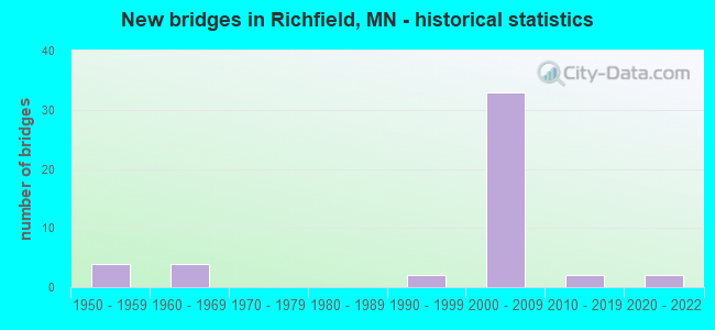
- New bridges - historical statistics
- 41950-1959
- 41960-1969
- 21990-1999
- 332000-2009
- 22010-2019
- 22020-2022
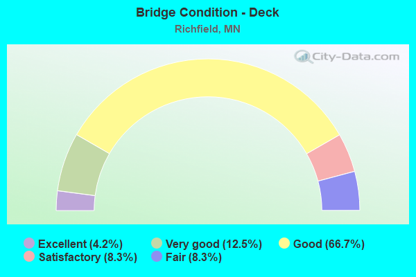
- Bridge Condition - Deck
- 4.2%Excellent
- 12.5%Very good
- 66.7%Good
- 8.3%Satisfactory
- 8.3%Fair
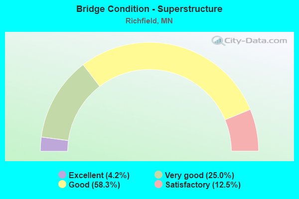
- Bridge Condition - Superstructure
- 4.2%Excellent
- 25.0%Very good
- 58.3%Good
- 12.5%Satisfactory
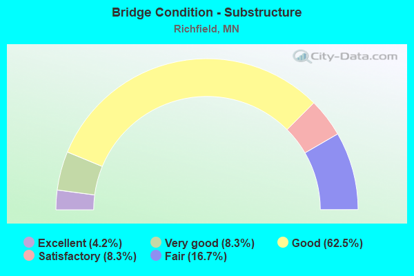
- Bridge Condition - Substructure
- 4.2%Excellent
- 8.3%Very good
- 62.5%Good
- 8.3%Satisfactory
- 16.7%Fair
Find on map >> Show street view
Structure Number: 27291, Location: 1.5 MI N OF JCT TH 494 (Lat: 44.883644, Lng: -93.246911), Route carried "on" structure: County highway 53, Year Built: 2005, Status: Open, Structure Length: 5.11m (16.77ft), Average Daily Traffic: 12,300 (year 2016), Average Future Daily Traffic: 12,300 (year 2039), Design Load: HS 25 or greater, Features Intersected: TH 77
Minimum Vertical Clearance: 30+ m (98+ ft), Kilometerpoint: 0.000, Lanes on structure: 4, Lanes under structure: 5, Owner: State Highway Agency, Approaching Roadway Width: 15.9m (52.2ft), Material/Design: Prestressed concrete, Design/Construction: Stringer/Multi-beam, Number Of Spans In Main Unit: 2, Length of Maximum Span: 24.8m (81.4ft), Curb or Sidewalk Widths: Left: 3.0m (9.8ft), Right: 0.0m, Curb-To-Curb Width: 15.9m (52.2ft), Out-to-Out Width: 19.5m (64.0ft)
Condition: Deck: Good, Superstructure: Very good, Substructure: Good, Operating Rating: 76.7 metric tons, Method Used To Determine Operating Rating: Load Factor (LF), Inventory Rating: 47.3 metric tons, Method Used To Determine Inventory Rating: Load Factor (LF), Structural Evaluation: Better than present minimum criteria, Deck Geometry: Meets minimum limits, Underclear: Somewhat better than minimum adequacy, Approach Roadway Alignment: Equal to present desirable criteria, Length Of Structure Improvement: 1.71m (5.61ft), Designated Inspection Frequency: Every 24 months, Inspection Date: July 2020, Bridge Improvement Cost: $999,999,000, Roadway Improvement Cost: $1,000, Total Project Cost: $1,000, Deck Structure Type: Concrete Cast-file-Place, Wearing Surface/Protective System: Wearing Surface: Monolithic Concrete, Deck Protection: Epoxy Coated Reinforcing
Find on map >> Show street view
Structure Number: 27V11, Location: 0.5 MI S OF JCT TH 62 (Lat: 44.883383, Lng: -93.295883), Route carried "on" structure: Interstate 35W, Year Built: 1999, Status: Open, Structure Length: 3.91m (12.83ft), Average Daily Traffic: 93,000 (year 2019), Truck Traffic: 4%, Average Future Daily Traffic: 112,000 (year 2039), Design Load: HS 25 or greater, Features Intersected: W 66th St
Minimum Vertical Clearance: 30+ m (98+ ft), Kilometerpoint: 0.000, Lanes on structure: 6, Lanes under structure: 6, Base Highway Network: Yes, Owner: State Highway Agency, Approaching Roadway Width: 35.4m (116.1ft), Skew: 30 degrees, Material/Design: Prestressed concrete, Design/Construction: Stringer/Multi-beam, Number Of Spans In Main Unit: 2, Number Of Approach Spans: 2, Length of Maximum Span: 18.2m (59.7ft), Curb-To-Curb Width: 37.2m (122.0ft), Out-to-Out Width: 39.1m (128.3ft)
Condition: Deck: Good, Superstructure: Good, Substructure: Satisfactory, Operating Rating: 50.6 metric tons, Method Used To Determine Operating Rating: Load Factor (LF), Inventory Rating: 30.2 metric tons, Method Used To Determine Inventory Rating: Load Factor (LF), Structural Evaluation: Equal to present minimum criteria, Deck Geometry: Superior to present desirable criteria, Underclear: Equal to present minimum criteria, Approach Roadway Alignment: Equal to present desirable criteria, Designated Inspection Frequency: Every 24 months, Inspection Date: June 2021, Deck Structure Type: Concrete Cast-file-Place, Wearing Surface/Protective System: Wearing Surface: Low Slump Concrete, Deck Protection: Epoxy Coated Reinforcing
Find on map >> Show street view
Structure Number: 27V63, Location: 0.5 MI E OF JCT TH 35W (Lat: 44.861858, Lng: -93.288383), Route carried "on" structure: City street 415, Year Built: 2009, Status: Open, Structure Length: 9.50m (31.17ft), Average Daily Traffic: 18,700 (year 2017), Average Future Daily Traffic: 18,700 (year 2039), Design Load: HL 93, Features Intersected: I 494
Minimum Vertical Clearance: 30+ m (98+ ft), Kilometerpoint: 0.000, Lanes on structure: 6, Lanes under structure: 6, Owner: State Highway Agency, Approaching Roadway Width: 29.9m (98.1ft), Material/Design: Steel, Design/Construction: Stringer/Multi-beam, Number Of Spans In Main Unit: 4, Length of Maximum Span: 29.3m (96.1ft), Curb or Sidewalk Widths: Left: 6.0m (19.7ft), Right: 6.0m (19.7ft), Curb-To-Curb Width: 29.9m (98.1ft), Out-to-Out Width: 65.8m (215.9ft)
Condition: Deck: Good, Superstructure: Good, Substructure: Fair, Operating Rating: 55.5 metric tons, Method Used To Determine Operating Rating: Load and Resistance Factor (LRFR), Inventory Rating: 33.3 metric tons, Method Used To Determine Inventory Rating: Load and Resistance Factor (LRFR), Structural Evaluation: Somewhat better than minimum adequacy, Deck Geometry: Superior to present desirable criteria, Underclear: Equal to present minimum criteria, Approach Roadway Alignment: Equal to present desirable criteria, Designated Inspection Frequency: Every 24 months, Inspection Date: August 2020, Deck Structure Type: Concrete Cast-file-Place, Wearing Surface/Protective System: Wearing Surface: Low Slump Concrete, Deck Protection: Epoxy Coated Reinforcing
Find on map >> Show street view
Structure Number: 27V65, Location: 0.1 MI S OF W JCT MN 62 (Lat: 44.888942, Lng: -93.295831), Route carried "on" structure: State highway 121, Year Built: 2007, Status: Open, Structure Length: 20.72m (67.98ft), Average Daily Traffic: 6,050 (year 2019), Truck Traffic: 8%, Average Future Daily Traffic: 7,500 (year 2039), Design Load: HL 93, Features Intersected: I 35W
Minimum Vertical Clearance: 30+ m (98+ ft), Kilometerpoint: 0.000, Lanes on structure: 2, Lanes under structure: 6, Base Highway Network: Yes, Owner: State Highway Agency, Approaching Roadway Width: 12.2m (40.0ft), Material/Design: Prestressed concrete continuous, Design/Construction: Segmental Box Girder, Number Of Spans In Main Unit: 4, Length of Maximum Span: 61.0m (200.1ft), Curb-To-Curb Width: 12.2m (40.0ft), Out-to-Out Width: 13.2m (43.3ft)
Condition: Deck: Good, Superstructure: Good, Substructure: Good, Operating Rating: 42.1 metric tons, Method Used To Determine Operating Rating: Load and Resistance Factor Rating (LRFR) rating reported by rating factor(RF) method using HL-93 loadings, Inventory Rating: 35.6 metric tons, Method Used To Determine Inventory Rating: Load and Resistance Factor Rating (LRFR) rating reported by rating factor(RF) method using HL-93 loadings, Structural Evaluation: Better than present minimum criteria, Deck Geometry: Better than present minimum criteria, Underclear: Somewhat better than minimum adequacy, Approach Roadway Alignment: Equal to present minimum criteria, Length Of Structure Improvement: 6.31m (20.70ft), Designated Inspection Frequency: Every 24 months, Inspection Date: June 2021, Bridge Improvement Cost: $999,999,000, Roadway Improvement Cost: $1,000, Total Project Cost: $1,000, Deck Structure Type: Concrete Cast-file-Place, Wearing Surface/Protective System: Wearing Surface: Epoxy Overlay, Deck Protection: Epoxy Coated Reinforcing
Find on map >> Show street view
Structure Number: 27V66, Location: 0.4 MI N JCT 66 ST W (Lat: 44.888414, Lng: -93.295239), Route carried "on" structure: Ramp Interstate 6330, Year Built: 2007, Status: Open, Structure Length: 15.52m (50.92ft), Average Daily Traffic: 1 (year 2009), Average Future Daily Traffic: 1 (year 2029), Design Load: HL 93, Features Intersected: I 35W ON RAMP
Minimum Vertical Clearance: 30+ m (98+ ft), Kilometerpoint: 0.000, Lanes on structure: 1, Lanes under structure: 1, Base Highway Network: Yes, Owner: State Highway Agency, Approaching Roadway Width: 9.1m (29.9ft), Material/Design: Prestressed concrete continuous, Design/Construction: Segmental Box Girder, Number Of Spans In Main Unit: 3, Length of Maximum Span: 61.0m (200.1ft), Curb-To-Curb Width: 9.1m (29.9ft), Out-to-Out Width: 10.2m (33.5ft)
Condition: Deck: Good, Superstructure: Good, Substructure: Good, Operating Rating: 61.6 metric tons, Method Used To Determine Operating Rating: Load and Resistance Factor Rating (LRFR) rating reported by rating factor(RF) method using HL-93 loadings, Inventory Rating: 35.6 metric tons, Method Used To Determine Inventory Rating: Load and Resistance Factor Rating (LRFR) rating reported by rating factor(RF) method using HL-93 loadings, Structural Evaluation: Better than present minimum criteria, Deck Geometry: Superior to present desirable criteria, Underclear: Meets minimum limits, Approach Roadway Alignment: Equal to present minimum criteria, Designated Inspection Frequency: Every 24 months, Inspection Date: June 2021, Deck Structure Type: Concrete Cast-file-Place, Wearing Surface/Protective System: Wearing Surface: Epoxy Overlay, Deck Protection: Epoxy Coated Reinforcing
Find on map >> Show street view
Structure Number: 27V67, Location: 0.1 MI W OF W JCT FAI 35W (Lat: 44.890472, Lng: -93.295769), Route carried "on" structure: State highway 62, Year Built: 2007, Status: Open, Structure Length: 4.54m (14.90ft), Average Daily Traffic: 49,000 (year 2017), Average Future Daily Traffic: 49,000 (year 2039), Design Load: HL 93, Features Intersected: MN 121
Minimum Vertical Clearance: 30+ m (98+ ft), Kilometerpoint: 0.000, Lanes on structure: 3, Lanes under structure: 3, Base Highway Network: Yes, Owner: State Highway Agency, Approaching Roadway Width: 17.1m (56.1ft), Skew: 1 degrees, Material/Design: Prestressed concrete, Design/Construction: Stringer/Multi-beam, Number Of Spans In Main Unit: 2, Length of Maximum Span: 23.6m (77.4ft), Curb-To-Curb Width: 17.1m (56.1ft), Out-to-Out Width: 18.1m (59.4ft)
Condition: Deck: Good, Superstructure: Good, Substructure: Good, Operating Rating: 62.2 metric tons, Method Used To Determine Operating Rating: Load Factor (LF), Inventory Rating: 36.9 metric tons, Method Used To Determine Inventory Rating: Load Factor (LF), Structural Evaluation: Better than present minimum criteria, Deck Geometry: Equal to present minimum criteria, Underclear: Equal to present minimum criteria, Approach Roadway Alignment: Equal to present desirable criteria, Length Of Structure Improvement: 1.68m (5.51ft), Designated Inspection Frequency: Every 24 months, Inspection Date: June 2021, Bridge Improvement Cost: $999,999,000, Roadway Improvement Cost: $1,000, Total Project Cost: $1,000, Deck Structure Type: Concrete Cast-file-Place, Wearing Surface/Protective System: Wearing Surface: Low Slump Concrete, Deck Protection: Epoxy Coated Reinforcing
Find on map >> Show street view
Structure Number: 27V68, Location: AT THE W JCT 35W; 62 (Lat: 44.889753, Lng: -93.293853), Route carried "on" structure: State highway 62, Year Built: 2007, Status: Open, Structure Length: 26.59m (87.24ft), Average Daily Traffic: 46,000 (year 2019), Truck Traffic: 3%, Average Future Daily Traffic: 49,000 (year 2039), Design Load: HL 93, Features Intersected: I 35W, MN 121, RAMP
Minimum Vertical Clearance: 30+ m (98+ ft), Kilometerpoint: 0.000, Lanes on structure: 3, Lanes under structure: 10, Base Highway Network: Yes, Owner: State Highway Agency, Approaching Roadway Width: 15.9m (52.2ft), Skew: 1 degrees, Material/Design: Steel continuous, Design/Construction: Stringer/Multi-beam, Number Of Spans In Main Unit: 4, Length of Maximum Span: 72.5m (237.9ft), Curb-To-Curb Width: 15.9m (52.2ft), Out-to-Out Width: 19.5m (64.0ft)
Condition: Deck: Good, Superstructure: Good, Substructure: Fair, Operating Rating: 61.7 metric tons, Method Used To Determine Operating Rating: Load Factor (LF), Inventory Rating: 36.9 metric tons, Method Used To Determine Inventory Rating: Load Factor (LF), Structural Evaluation: Somewhat better than minimum adequacy, Deck Geometry: Somewhat better than minimum adequacy, Underclear: Equal to present minimum criteria, Approach Roadway Alignment: Equal to present desirable criteria, Length Of Structure Improvement: 8.11m (26.61ft), Designated Inspection Frequency: Every 24 months, Inspection Date: June 2021, Bridge Improvement Cost: $999,999,000, Roadway Improvement Cost: $1,000, Total Project Cost: $1,000, Deck Structure Type: Concrete Cast-file-Place, Wearing Surface/Protective System: Wearing Surface: Low Slump Concrete, Deck Protection: Epoxy Coated Reinforcing
Find on map >> Show street view
Structure Number: 27V69, Location: 0.1 MI W OF W JCT FAI 35W (Lat: 44.890622, Lng: -93.295700), Route carried "on" structure: Ramp State highway 6322, Year Built: 2007, Status: Open, Structure Length: 4.54m (14.90ft), Average Daily Traffic: 1 (year 2009), Average Future Daily Traffic: 1 (year 2029), Design Load: HL 93, Features Intersected: TH 121
Minimum Vertical Clearance: 30+ m (98+ ft), Kilometerpoint: 0.000, Lanes on structure: 1, Lanes under structure: 3, Base Highway Network: Yes, Owner: State Highway Agency, Approaching Roadway Width: 12.2m (40.0ft), Skew: 1 degrees, Material/Design: Prestressed concrete, Design/Construction: Stringer/Multi-beam, Number Of Spans In Main Unit: 2, Length of Maximum Span: 23.2m (76.1ft), Curb-To-Curb Width: 12.2m (40.0ft), Out-to-Out Width: 13.2m (43.3ft)
Condition: Deck: Good, Superstructure: Good, Substructure: Good, Operating Rating: 64.7 metric tons, Method Used To Determine Operating Rating: Load Factor (LF), Inventory Rating: 38.4 metric tons, Method Used To Determine Inventory Rating: Load Factor (LF), Structural Evaluation: Better than present minimum criteria, Deck Geometry: Superior to present desirable criteria, Underclear: Equal to present minimum criteria, Approach Roadway Alignment: Better than present minimum criteria, Length Of Structure Improvement: 1.68m (5.51ft), Designated Inspection Frequency: Every 24 months, Inspection Date: June 2021, Bridge Improvement Cost: $981,000,000, Roadway Improvement Cost: $1,000, Total Project Cost: $1,000, Deck Structure Type: Concrete Cast-file-Place, Wearing Surface/Protective System: Wearing Surface: Monolithic Concrete, Deck Protection: Epoxy Coated Reinforcing
Find on map >> Show street view
Structure Number: 27V7, Location: 0.3 MI E OF W JCT 35W-62 (Lat: 44.890564, Lng: -93.288344), Route carried "on" structure: State highway 62, Year Built: 2007, Status: Open, Structure Length: 3.75m (12.30ft), Average Daily Traffic: 70,000 (year 2019), Truck Traffic: 2%, Average Future Daily Traffic: 35,000 (year 2039), Design Load: HL 93, Features Intersected: LYNDALE AVE SO
Minimum Vertical Clearance: 30+ m (98+ ft), Kilometerpoint: 0.000, Lanes on structure: 3, Lanes under structure: 6, Base Highway Network: Yes, Owner: State Highway Agency, Approaching Roadway Width: 18.3m (60.0ft), Material/Design: Prestressed concrete, Design/Construction: Stringer/Multi-beam, Number Of Spans In Main Unit: 1, Length of Maximum Span: 35.1m (115.2ft), Curb-To-Curb Width: 18.3m (60.0ft), Out-to-Out Width: 19.5m (64.0ft)
Condition: Deck: Good, Superstructure: Good, Substructure: Good, Operating Rating: 80.0 metric tons, Method Used To Determine Operating Rating: Load Factor (LF), Inventory Rating: 41.2 metric tons, Method Used To Determine Inventory Rating: Load Factor (LF), Structural Evaluation: Better than present minimum criteria, Deck Geometry: Better than present minimum criteria, Underclear: Equal to present minimum criteria, Approach Roadway Alignment: Equal to present desirable criteria, Designated Inspection Frequency: Every 24 months, Inspection Date: June 2021, Deck Structure Type: Concrete Cast-file-Place, Wearing Surface/Protective System: Wearing Surface: Low Slump Concrete, Deck Protection: Epoxy Coated Reinforcing
Find on map >> Show street view
Structure Number: 27V71, Location: 0.3 MI E OF W JCT MN 62 (Lat: 44.890258, Lng: -93.288353), Route carried "on" structure: Interstate 35W, Year Built: 2007, Status: Open, Structure Length: 3.75m (12.30ft), Average Daily Traffic: 98,000 (year 2019), Truck Traffic: 4%, Average Future Daily Traffic: 104,000 (year 2039), Design Load: HL 93, Features Intersected: LYNDALE AVE SO
Minimum Vertical Clearance: 30+ m (98+ ft), Kilometerpoint: 0.000, Lanes on structure: 6, Lanes under structure: 6, Base Highway Network: Yes, Owner: State Highway Agency, Approaching Roadway Width: 34.1m (111.9ft), Skew: 30 degrees, Material/Design: Prestressed concrete, Design/Construction: Stringer/Multi-beam, Number Of Spans In Main Unit: 1, Length of Maximum Span: 35.1m (115.2ft), Curb-To-Curb Width: 34.1m (111.9ft), Out-to-Out Width: 46.3m (151.9ft)
Condition: Deck: Good, Superstructure: Good, Substructure: Good, Operating Rating: 81.0 metric tons, Method Used To Determine Operating Rating: Load Factor (LF), Inventory Rating: 41.8 metric tons, Method Used To Determine Inventory Rating: Load Factor (LF), Structural Evaluation: Better than present minimum criteria, Deck Geometry: Superior to present desirable criteria, Underclear: Equal to present minimum criteria, Approach Roadway Alignment: Equal to present desirable criteria, Designated Inspection Frequency: Every 24 months, Inspection Date: June 2021, Deck Structure Type: Concrete Cast-file-Place, Wearing Surface/Protective System: Wearing Surface: Low Slump Concrete, Deck Protection: Epoxy Coated Reinforcing
Find on map >> Show street view
Structure Number: 27V72, Location: 0.3 MI E OF W JCT MN 62 (Lat: 44.889903, Lng: -93.288322), Route carried "on" structure: State highway 62, Year Built: 2007, Status: Open, Structure Length: 3.75m (12.30ft), Average Daily Traffic: 35,000 (year 2019), Truck Traffic: 2%, Average Future Daily Traffic: 35,000 (year 2039), Design Load: HL 93, Features Intersected: LYNDALE AVE SO
Minimum Vertical Clearance: 30+ m (98+ ft), Kilometerpoint: 0.000, Lanes on structure: 2, Lanes under structure: 6, Base Highway Network: Yes, Owner: State Highway Agency, Approaching Roadway Width: 11.6m (38.1ft), Material/Design: Prestressed concrete, Design/Construction: Stringer/Multi-beam, Number Of Spans In Main Unit: 1, Length of Maximum Span: 35.1m (115.2ft), Curb-To-Curb Width: 11.6m (38.1ft), Out-to-Out Width: 20.1m (65.9ft)
Condition: Deck: Good, Superstructure: Very good, Substructure: Good, Operating Rating: 79.5 metric tons, Method Used To Determine Operating Rating: Load Factor (LF), Inventory Rating: 35.3 metric tons, Method Used To Determine Inventory Rating: Load Factor (LF), Structural Evaluation: Better than present minimum criteria, Deck Geometry: Equal to present minimum criteria, Underclear: Equal to present minimum criteria, Approach Roadway Alignment: Equal to present desirable criteria, Designated Inspection Frequency: Every 24 months, Inspection Date: June 2021, Deck Structure Type: Concrete Cast-file-Place, Wearing Surface/Protective System: Wearing Surface: Low Slump Concrete, Deck Protection: Epoxy Coated Reinforcing
Find on map >> Show street view
Structure Number: 27V73, Location: 0.3 MI E OF JCT 35W; 62 (Lat: 44.889653, Lng: -93.289947), Route carried "on" structure: Ramp Interstate 6330, Year Built: 2007, Status: Open, Structure Length: 12.79m (41.96ft), Average Daily Traffic: 1 (year 2009), Average Future Daily Traffic: 1 (year 2029), Design Load: HL 93, Features Intersected: RAMP (62 EB TO LYNDALE)
Minimum Vertical Clearance: 30+ m (98+ ft), Kilometerpoint: 0.000, Lanes on structure: 2, Lanes under structure: 1, Base Highway Network: Yes, Owner: State Highway Agency, Approaching Roadway Width: 9.1m (29.9ft), Material/Design: Prestressed concrete continuous, Design/Construction: Segmental Box Girder, Number Of Spans In Main Unit: 3, Length of Maximum Span: 51.8m (169.9ft), Curb-To-Curb Width: 9.1m (29.9ft), Out-to-Out Width: 10.2m (33.5ft)
Condition: Deck: Satisfactory, Superstructure: Good, Substructure: Good, Operating Rating: 48.6 metric tons, Method Used To Determine Operating Rating: Load and Resistance Factor Rating (LRFR) rating reported by rating factor(RF) method using HL-93 loadings, Inventory Rating: 42.1 metric tons, Method Used To Determine Inventory Rating: Load and Resistance Factor Rating (LRFR) rating reported by rating factor(RF) method using HL-93 loadings, Structural Evaluation: Better than present minimum criteria, Deck Geometry: Meets minimum limits, Underclear: Somewhat better than minimum adequacy, Approach Roadway Alignment: Equal to present desirable criteria, Designated Inspection Frequency: Every 24 months, Inspection Date: June 2021, Deck Structure Type: Concrete Cast-file-Place, Wearing Surface/Protective System: Wearing Surface: Epoxy Overlay, Deck Protection: Epoxy Coated Reinforcing
Find on map >> Show street view
Structure Number: 27V74A, Location: 0.6 MI E OF W JCT MN 62 (Lat: 44.890064, Lng: -93.283250), Route carried "on" structure: Interstate 35W, Year Built: 2007, Status: Open, Structure Length: 1.91m (6.27ft), Average Daily Traffic: 98,000 (year 2019), Truck Traffic: 4%, Average Future Daily Traffic: 104,000 (year 2039), Design Load: HL 93, Features Intersected: CP RAIL
Minimum Vertical Clearance: 30+ m (98+ ft), Kilometerpoint: 0.000, Lanes on structure: 8, Base Highway Network: Yes, Owner: State Highway Agency, Approaching Roadway Width: 44.3m (145.3ft), Skew: 30 degrees, Material/Design: Prestressed concrete, Design/Construction: Stringer/Multi-beam, Number Of Spans In Main Unit: 1, Length of Maximum Span: 16.8m (55.1ft), Curb-To-Curb Width: 44.3m (145.3ft), Out-to-Out Width: 46.2m (151.6ft)
Condition: Deck: Very good, Superstructure: Very good, Substructure: Very good, Operating Rating: 54.3 metric tons, Method Used To Determine Operating Rating: Load Factor (LF), Inventory Rating: 32.7 metric tons, Method Used To Determine Inventory Rating: Load Factor (LF), Structural Evaluation: Equal to present desirable criteria, Deck Geometry: Superior to present desirable criteria, Underclear: Somewhat better than minimum adequacy, Approach Roadway Alignment: Equal to present desirable criteria, Designated Inspection Frequency: Every 24 months, Inspection Date: June 2021, Deck Structure Type: Concrete Cast-file-Place, Wearing Surface/Protective System: Wearing Surface: Low Slump Concrete, Deck Protection: Epoxy Coated Reinforcing
Find on map >> Show street view
Structure Number: 27V74B, Location: 0.6 MI E OF W JCT I 35W (Lat: 44.889928, Lng: -93.283219), Route carried "on" structure: State highway 62, Year Built: 2007, Status: Open, Structure Length: 1.91m (6.27ft), Average Daily Traffic: 48,000 (year 2019), Truck Traffic: 3%, Average Future Daily Traffic: 40,000 (year 2039), Design Load: HL 93, Features Intersected: CP RAIL
Minimum Vertical Clearance: 30+ m (98+ ft), Kilometerpoint: 0.000, Lanes on structure: 2, Base Highway Network: Yes, Owner: State Highway Agency, Approaching Roadway Width: 15.5m (50.9ft), Material/Design: Prestressed concrete, Design/Construction: Stringer/Multi-beam, Number Of Spans In Main Unit: 1, Length of Maximum Span: 16.8m (55.1ft), Curb-To-Curb Width: 15.5m (50.9ft), Out-to-Out Width: 16.2m (53.1ft)
Condition: Deck: Good, Superstructure: Very good, Substructure: Good, Operating Rating: 54.3 metric tons, Method Used To Determine Operating Rating: Load Factor (LF), Inventory Rating: 32.7 metric tons, Method Used To Determine Inventory Rating: Load Factor (LF), Structural Evaluation: Better than present minimum criteria, Deck Geometry: Superior to present desirable criteria, Underclear: Somewhat better than minimum adequacy, Approach Roadway Alignment: Equal to present desirable criteria, Designated Inspection Frequency: Every 24 months, Inspection Date: June 2021, Deck Structure Type: Concrete Cast-file-Place, Wearing Surface/Protective System: Wearing Surface: Low Slump Concrete, Deck Protection: Epoxy Coated Reinforcing
Find on map >> Show street view
Structure Number: 27V74C, Location: 0.6 MI E OF W JCT I 35W (Lat: 44.890475, Lng: -93.283303), Route carried "on" structure: State highway 62, Year Built: 2007, Status: Open, Structure Length: 1.91m (6.27ft), Average Daily Traffic: 40,000 (year 2017), Average Future Daily Traffic: 40,000 (year 2039), Design Load: HL 93, Features Intersected: CP RAIL
Minimum Vertical Clearance: 30+ m (98+ ft), Kilometerpoint: 0.000, Lanes on structure: 4, Base Highway Network: Yes, Owner: State Highway Agency, Approaching Roadway Width: 23.5m (77.1ft), Material/Design: Prestressed concrete, Design/Construction: Stringer/Multi-beam, Number Of Spans In Main Unit: 1, Length of Maximum Span: 16.8m (55.1ft), Curb-To-Curb Width: 23.5m (77.1ft), Out-to-Out Width: 24.3m (79.7ft)
Condition: Deck: Good, Superstructure: Very good, Substructure: Good, Operating Rating: 54.3 metric tons, Method Used To Determine Operating Rating: Load Factor (LF), Inventory Rating: 32.7 metric tons, Method Used To Determine Inventory Rating: Load Factor (LF), Structural Evaluation: Better than present minimum criteria, Deck Geometry: Superior to present desirable criteria, Underclear: Somewhat better than minimum adequacy, Approach Roadway Alignment: Equal to present desirable criteria, Designated Inspection Frequency: Every 24 months, Inspection Date: June 2021, Deck Structure Type: Concrete Cast-file-Place, Wearing Surface/Protective System: Wearing Surface: Low Slump Concrete, Deck Protection: Epoxy Coated Reinforcing
Find on map >> Show street view
Structure Number: 27V78, Location: 0.86 MI E OF JCT MN121 (Lat: 44.889992, Lng: -93.278106), Route carried "on" structure: State highway 62, Year Built: 2007, Status: Open, Structure Length: 2.76m (9.06ft), Average Daily Traffic: 48,000 (year 2019), Truck Traffic: 3%, Average Future Daily Traffic: 40,000 (year 2039), Design Load: HL 93, Features Intersected: NICOLLET AVE SO
Minimum Vertical Clearance: 30+ m (98+ ft), Kilometerpoint: 0.000, Lanes on structure: 2, Lanes under structure: 4, Base Highway Network: Yes, Owner: State Highway Agency, Approaching Roadway Width: 14.6m (47.9ft), Skew: 1 degrees, Material/Design: Prestressed concrete, Design/Construction: Stringer/Multi-beam, Number Of Spans In Main Unit: 1, Length of Maximum Span: 25.1m (82.3ft), Curb-To-Curb Width: 14.6m (47.9ft), Out-to-Out Width: 17.3m (56.8ft)
Condition: Deck: Good, Superstructure: Good, Substructure: Good, Operating Rating: 62.7 metric tons, Method Used To Determine Operating Rating: Load Factor (LF), Inventory Rating: 37.6 metric tons, Method Used To Determine Inventory Rating: Load Factor (LF), Structural Evaluation: Better than present minimum criteria, Deck Geometry: Superior to present desirable criteria, Underclear: Equal to present minimum criteria, Approach Roadway Alignment: Equal to present desirable criteria, Length Of Structure Improvement: 1.01m (3.31ft), Designated Inspection Frequency: Every 24 months, Inspection Date: June 2021, Bridge Improvement Cost: $780,000,000, Roadway Improvement Cost: $1,000, Total Project Cost: $1,000, Deck Structure Type: Concrete Cast-file-Place, Wearing Surface/Protective System: Wearing Surface: Low Slump Concrete, Deck Protection: Epoxy Coated Reinforcing
Find on map >> Show street view
Structure Number: 27V86, Location: 0.1 MI W OF E JCT MN 62 (Lat: 44.890100, Lng: -93.278092), Route carried "on" structure: Interstate 35W, Year Built: 2008, Status: Open, Structure Length: 2.79m (9.15ft), Average Daily Traffic: 49,000 (year 2019), Truck Traffic: 4%, Average Future Daily Traffic: 52,000 (year 2039), Design Load: HL 93, Features Intersected: NICOLLET AVE SO(CSAH 52)
Minimum Vertical Clearance: 30+ m (98+ ft), Kilometerpoint: 0.000, Lanes on structure: 4, Lanes under structure: 4, Base Highway Network: Yes, Owner: State Highway Agency, Approaching Roadway Width: 22.3m (73.2ft), Skew: 1 degrees, Material/Design: Prestressed concrete, Design/Construction: Stringer/Multi-beam, Number Of Spans In Main Unit: 1, Length of Maximum Span: 27.0m (88.6ft), Curb-To-Curb Width: 22.3m (73.2ft), Out-to-Out Width: 27.5m (90.2ft)
Condition: Deck: Very good, Superstructure: Good, Substructure: Good, Operating Rating: 62.5 metric tons, Method Used To Determine Operating Rating: Load Factor (LF), Inventory Rating: 36.4 metric tons, Method Used To Determine Inventory Rating: Load Factor (LF), Structural Evaluation: Better than present minimum criteria, Deck Geometry: Superior to present desirable criteria, Underclear: Somewhat better than minimum adequacy, Approach Roadway Alignment: Equal to present desirable criteria, Length Of Structure Improvement: 1.01m (3.31ft), Designated Inspection Frequency: Every 24 months, Inspection Date: June 2021, Bridge Improvement Cost: $999,999,000, Roadway Improvement Cost: $1,000, Total Project Cost: $1,000, Deck Structure Type: Concrete Cast-file-Place, Wearing Surface/Protective System: Wearing Surface: Low Slump Concrete, Deck Protection: Epoxy Coated Reinforcing
Find on map >> Show street view
Structure Number: 27V98, Location: 0.3 MI N JCT TH 494 (Lat: 44.865569, Lng: -93.298806), Route carried "on" structure: City street 361, Year Built: 2008, Status: Open, Structure Length: 7.57m (24.84ft), Average Daily Traffic: 23,200 (year 2017), Average Future Daily Traffic: 23,200 (year 2039), Design Load: HL 93, Features Intersected: I 35W
Minimum Vertical Clearance: 30+ m (98+ ft), Kilometerpoint: 0.000, Lanes on structure: 4, Lanes under structure: 6, Owner: State Highway Agency, Maintenance Responsibility: State Park, Forest, or Reservation Agency, Approaching Roadway Width: 20.7m (67.9ft), Skew: 20 degrees, Material/Design: Prestressed concrete, Design/Construction: Stringer/Multi-beam, Number Of Spans In Main Unit: 2, Length of Maximum Span: 36.3m (119.1ft), Curb or Sidewalk Widths: Left: 3.7m (12.1ft), Right: 2.4m (7.9ft), Curb-To-Curb Width: 20.7m (67.9ft), Out-to-Out Width: 35.1m (115.2ft)
Condition: Deck: Good, Superstructure: Good, Substructure: Good, Operating Rating: 96.3 metric tons, Method Used To Determine Operating Rating: Load Factor (LF), Inventory Rating: 49.0 metric tons, Method Used To Determine Inventory Rating: Load Factor (LF), Structural Evaluation: Better than present minimum criteria, Deck Geometry: Superior to present desirable criteria, Underclear: Meets minimum limits, Approach Roadway Alignment: Equal to present desirable criteria, Designated Inspection Frequency: Every 24 months, Inspection Date: June 2021, Deck Structure Type: Concrete Cast-file-Place, Wearing Surface/Protective System: Wearing Surface: Low Slump Concrete, Deck Protection: Epoxy Coated Reinforcing
Find on map >> Show street view
Structure Number: 27W19, Location: 0.5 MI W OF JCT TH 77 (Lat: 44.862175, Lng: -93.258003), Route carried "on" structure: , Year Built: 2014, Status: Open, Structure Length: 5.66m (18.57ft), Features Intersected: I 494, Facility Carried by Structure: PEDESTRIAN
Minimum Vertical Clearance: 30+ m (98+ ft), Lanes under structure: 7, Owner: State Highway Agency, Material/Design: Steel, Design/Construction: Truss - Thru, Number Of Spans In Main Unit: 1, Number Of Approach Spans: 2, Length of Maximum Span: 36.9m (121.1ft), Out-to-Out Width: 3.7m (12.1ft)
Condition: Deck: Very good, Superstructure: Very good, Substructure: Very good, Underclear: Equal to present minimum criteria, Bridge Posting: Required (Relationship of Operating Rating to Maximum Legal Load: > 39.9% below), Designated Inspection Frequency: Every 24 months, Inspection Date: August 2020, Deck Structure Type: Concrete Cast-file-Place, Wearing Surface/Protective System: Wearing Surface: Monolithic Concrete, Deck Protection: Epoxy Coated Reinforcing
Find on map >> Show street view
Structure Number: 7268, Location: 0.7 MI W OF JCT TH 35W (Lat: 44.890775, Lng: -93.308669), Route carried "on" structure: City street 426, Year Built: 1962, Year Reconstructed: 2013, Status: Open, Structure Length: 4.64m (15.22ft), Average Daily Traffic: 13,900 (year 2015), Average Future Daily Traffic: 13,900 (year 2039), Design Load: H 20, Features Intersected: TH 62
Minimum Vertical Clearance: 30+ m (98+ ft), Kilometerpoint: 0.000, Lanes on structure: 4, Lanes under structure: 4, Owner: State Highway Agency, Approaching Roadway Width: 15.2m (49.9ft), Material/Design: Steel continuous, Design/Construction: Stringer/Multi-beam, Number Of Spans In Main Unit: 2, Length of Maximum Span: 22.6m (74.1ft), Curb or Sidewalk Widths: Left: 1.5m (4.9ft), Right: 1.5m (4.9ft), Curb-To-Curb Width: 15.9m (52.2ft), Out-to-Out Width: 20.2m (66.3ft)
Condition: Deck: Good, Superstructure: Good, Substructure: Satisfactory, Operating Rating: 49.9 metric tons, Method Used To Determine Operating Rating: Load Factor (LF), Inventory Rating: 29.7 metric tons, Method Used To Determine Inventory Rating: Load Factor (LF), Structural Evaluation: Equal to present minimum criteria, Deck Geometry: Meets minimum limits, Underclear: High priority of corrective action, Approach Roadway Alignment: Equal to present desirable criteria, Length Of Structure Improvement: 1.55m (5.09ft), Designated Inspection Frequency: Every 24 months, Inspection Date: August 2020, Bridge Improvement Cost: $999,999,000, Roadway Improvement Cost: $73,000,000, Total Project Cost: $999,999,000, Deck Structure Type: Concrete Cast-file-Place, Wearing Surface/Protective System: Wearing Surface: Low Slump Concrete, Deck Protection: Epoxy Coated Reinforcing
Find on map >> Show street view
Structure Number: 908, Location: 0.5 MI W OF JCT TH 77 (Lat: 44.862161, Lng: -93.258011), Route carried "on" structure: City street 115, Year Built: 1959, Status: Open, Structure Length: 5.66m (18.57ft), Average Daily Traffic: 6,400 (year 2017), Average Future Daily Traffic: 6,400 (year 2039), Design Load: HS 20, Features Intersected: I 494
Minimum Vertical Clearance: 30+ m (98+ ft), Kilometerpoint: 0.000, Lanes on structure: 2, Lanes under structure: 7, Owner: State Highway Agency, Approaching Roadway Width: 11.0m (36.1ft), Material/Design: Prestressed concrete, Design/Construction: Stringer/Multi-beam, Number Of Spans In Main Unit: 2, Number Of Approach Spans: 2, Length of Maximum Span: 17.8m (58.4ft), Curb or Sidewalk Widths: Left: 1.9m (6.2ft), Right: 0.0m, Curb-To-Curb Width: 10.5m (34.4ft), Out-to-Out Width: 12.8m (42.0ft)
Condition: Deck: Fair, Superstructure: Satisfactory, Substructure: Fair, Operating Rating: 53.5 metric tons, Method Used To Determine Operating Rating: Load Factor (LF), Inventory Rating: 32.7 metric tons, Method Used To Determine Inventory Rating: Load Factor (LF), Structural Evaluation: Somewhat better than minimum adequacy, Deck Geometry: Meets minimum limits, Underclear: Meets minimum limits, Approach Roadway Alignment: Better than present minimum criteria, Length Of Structure Improvement: 1.89m (6.20ft), Designated Inspection Frequency: Every 24 months, Inspection Date: August 2020, Bridge Improvement Cost: $999,999,000, Roadway Improvement Cost: $60,000,000, Total Project Cost: $901,000,000, Deck Structure Type: Concrete Cast-file-Place, Wearing Surface/Protective System: Wearing Surface: Low Slump Concrete, Deck Protection: Other
Find on map >> Show street view
Structure Number: 9195, Location: 1.5 MI N OF JCT TH 494 (Lat: 44.883511, Lng: -93.246911), Route carried "on" structure: County highway 53, Year Built: 1958, Status: Open, Structure Length: 5.66m (18.57ft), Average Daily Traffic: 12,300 (year 2016), Average Future Daily Traffic: 12,300 (year 2039), Design Load: HS 20, Features Intersected: TH 77
Minimum Vertical Clearance: 30+ m (98+ ft), Kilometerpoint: 0.000, Lanes on structure: 4, Lanes under structure: 4, Owner: State Highway Agency, Approaching Roadway Width: 15.9m (52.2ft), Material/Design: Prestressed concrete, Design/Construction: Stringer/Multi-beam, Number Of Spans In Main Unit: 4, Length of Maximum Span: 17.0m (55.8ft), Curb or Sidewalk Widths: Left: 0.0m, Right: 1.5m (4.9ft), Curb-To-Curb Width: 15.9m (52.2ft), Out-to-Out Width: 19.2m (63.0ft)
Condition: Deck: Fair, Superstructure: Satisfactory, Substructure: Fair, Operating Rating: 78.4 metric tons, Method Used To Determine Operating Rating: Load Factor (LF), Inventory Rating: 44.4 metric tons, Method Used To Determine Inventory Rating: Load Factor (LF), Structural Evaluation: Somewhat better than minimum adequacy, Deck Geometry: Meets minimum limits, Underclear: Meets minimum limits, Approach Roadway Alignment: Equal to present desirable criteria, Length Of Structure Improvement: 1.89m (6.20ft), Designated Inspection Frequency: Every 24 months, Inspection Date: July 2020, Bridge Improvement Cost: $999,999,000, Total Project Cost: $999,999,000, Deck Structure Type: Concrete Cast-file-Place, Wearing Surface/Protective System: Wearing Surface: Low Slump Concrete
Find on map >> Show street view
Structure Number: 9888, Location: 0.6 MI N OF JCT TH 494 (Lat: 44.870992, Lng: -93.298867), Route carried "on" structure: , Year Built: 1960, Status: Open, Structure Length: 4.87m (15.98ft), Features Intersected: I 35W, Facility Carried by Structure: PEDESTRIAN
Lanes under structure: 4, Owner: State Highway Agency, Material/Design: Steel continuous, Design/Construction: Stringer/Multi-beam, Number Of Spans In Main Unit: 2, Length of Maximum Span: 23.0m (75.5ft), Out-to-Out Width: 2.1m (6.9ft)
Condition: Deck: Satisfactory, Superstructure: Satisfactory, Substructure: Good, Underclear: Somewhat better than minimum adequacy, Bridge Posting: Required (Relationship of Operating Rating to Maximum Legal Load: > 39.9% below), Designated Inspection Frequency: Every 24 months, Inspection Date: June 2021, Deck Structure Type: Concrete Cast-file-Place
Find on map >> Show street view
Structure Number: 99208, Location: 0.1 MI N OF JCT I 494 (Lat: 44.863753, Lng: -93.247211), Route carried "on" structure: State highway 77, Year Built: 2021, Status: Open, Structure Length: 1.86m (6.10ft), Average Daily Traffic: 32,000 (year 2019), Truck Traffic: 3%, Average Future Daily Traffic: 36,000 (year 2039), Design Load: HL 93, Features Intersected: 77 NB OFF RAMP TO WB 494
Minimum Vertical Clearance: 30+ m (98+ ft), Kilometerpoint: 0.000, Lanes on structure: 2, Lanes under structure: 1, Base Highway Network: Yes, Owner: State Highway Agency, Approaching Roadway Width: 9.1m (29.9ft), Material/Design: Steel, Design/Construction: Truss - Thru, Number Of Spans In Main Unit: 1, Length of Maximum Span: 18.1m (59.4ft), Curb-To-Curb Width: 9.1m (29.9ft), Out-to-Out Width: 11.3m (37.1ft)
Condition: Deck: Excellent, Superstructure: Excellent, Substructure: Excellent, Operating Rating: 36.9 metric tons, Method Used To Determine Operating Rating: Load and Resistance Factor Rating (LRFR) rating reported by rating factor(RF) method using HL-93 loadings, Inventory Rating: 28.5 metric tons, Method Used To Determine Inventory Rating: Load and Resistance Factor Rating (LRFR) rating reported by rating factor(RF) method using HL-93 loadings, Structural Evaluation: Better than present minimum criteria, Deck Geometry: High priority of replacement, Underclear: Meets minimum limits, Approach Roadway Alignment: Equal to present desirable criteria, Designated Inspection Frequency: Every 24 months, Inspection Date: November 2021, Deck Structure Type: Corrugated Steel, Wearing Surface/Protective System: Wearing Surface: Bituminous, Membrane: Preformed Fabric
Find on map >> Show street view
Structure Number: 27291, Location: 1.5 MI N OF JCT TH 494 (Lat: 44.883644, Lng: -93.246911), Route carried "under" structure: State highway 77, Year Built: 2005, Structure Length: 0. m, Average Daily Traffic: 66,000 (year 2019), Truck Traffic: 3%, Features Intersected: TH 77, Facility Carried by Structure: CSAH 53
Minimum Vertical Clearance: 4.91m (16.11ft), Kilometerpoint: 0.000, Lanes on structure: 4, Lanes under structure: 5, Material/Design: Prestressed concrete, Design/Construction: Stringer/Multi-beam, Length of Maximum Span: 24.8m (81.4ft)
Find on map >> Show street view
Structure Number: 27V11, Location: 0.5 MI S OF JCT TH 62 (Lat: 44.883383, Lng: -93.295883), Route carried "under" structure: County highway 53, Year Built: 1999, Structure Length: 0. m, Average Daily Traffic: 23,800 (year 2007), Features Intersected: W 66th St, Facility Carried by Structure: I 35W
Minimum Vertical Clearance: 4.97m (16.31ft), Kilometerpoint: 0.000, Lanes on structure: 6, Lanes under structure: 6, Material/Design: Prestressed concrete, Design/Construction: Stringer/Multi-beam, Length of Maximum Span: 18.2m (59.7ft)
Find on map >> Show street view
Structure Number: 27V63, Location: 0.5 MI E OF JCT TH 35W (Lat: 44.861858, Lng: -93.288383), Route carried "under" structure: Interstate 494, Year Built: 2009, Structure Length: 0. m, Average Daily Traffic: 130,000 (year 2019), Truck Traffic: 5%, Features Intersected: I 494, Facility Carried by Structure: MSAS 415
Minimum Vertical Clearance: 5.15m (16.90ft), Kilometerpoint: 0.000, Lanes under structure: 6, Material/Design: Steel, Design/Construction: Stringer/Multi-beam, Length of Maximum Span: 29.3m (96.1ft)
Find on map >> Show street view
Structure Number: 27V65, Location: 0.1 MI S OF W JCT MN 62 (Lat: 44.888942, Lng: -93.295831), Route carried "under" structure: Interstate 35W, Year Built: 2007, Structure Length: 0. m, Average Daily Traffic: 67,000 (year 2019), Truck Traffic: 4%, Features Intersected: I 35W, Facility Carried by Structure: MN 121
Minimum Vertical Clearance: 7.07m (23.20ft), Kilometerpoint: 0.000, Lanes on structure: 2, Lanes under structure: 6, Material/Design: Prestressed concrete continuous, Design/Construction: Segmental Box Girder, Length of Maximum Span: 61.0m (200.1ft)
Find on map >> Show street view
Structure Number: 27V66, Location: 0.4 MI N JCT 66 ST W (Lat: 44.888414, Lng: -93.295239), Route carried "under" structure: Ramp Interstate 6331, Year Built: 2007, Structure Length: 0. m, Average Daily Traffic: 1 (year 2009), Features Intersected: I 35W ON RAMP, Facility Carried by Structure: CON 6330
Minimum Vertical Clearance: 5.00m (16.40ft), Kilometerpoint: 0.000, Lanes on structure: 1, Lanes under structure: 1, Material/Design: Prestressed concrete continuous, Design/Construction: Segmental Box Girder, Length of Maximum Span: 61.0m (200.1ft)
Find on map >> Show street view
Structure Number: 27V67, Location: 0.1 MI W OF W JCT FAI 35W (Lat: 44.890472, Lng: -93.295769), Route carried "under" structure: State highway 121, Year Built: 2007, Structure Length: 0. m, Average Daily Traffic: 12,100 (year 2019), Truck Traffic: 8%, Features Intersected: MN 121, Facility Carried by Structure: MN 62
Minimum Vertical Clearance: 5.70m (18.70ft), Kilometerpoint: 0.000, Lanes on structure: 3, Lanes under structure: 3, Material/Design: Prestressed concrete, Design/Construction: Stringer/Multi-beam, Length of Maximum Span: 23.6m (77.4ft)
Find on map >> Show street view
Structure Number: 27V68, Location: AT THE W JCT 35W; 62 (Lat: 44.889753, Lng: -93.293853), Route carried "under" structure: Ramp State highway 6337, Year Built: 2007, Structure Length: 0. m, Average Daily Traffic: 1 (year 2009), Features Intersected: I 35W, MN 121, RAMP, Facility Carried by Structure: MN 62
Minimum Vertical Clearance: 5.30m (17.39ft), Kilometerpoint: 0.000, Lanes on structure: 3, Lanes under structure: 1, Material/Design: Steel continuous, Design/Construction: Stringer/Multi-beam, Length of Maximum Span: 72.5m (237.9ft)
Find on map >> Show street view
Structure Number: 27V68, Location: AT THE W JCT 35W; 62 (Lat: 44.889753, Lng: -93.293853), Route carried "under" structure: Interstate 35W, Year Built: 2007, Structure Length: 0. m, Average Daily Traffic: 67,000 (year 2019), Truck Traffic: 4%, Features Intersected: I 35W, MN 121, RAMP, Facility Carried by Structure: MN 62
Minimum Vertical Clearance: 5.18m (16.99ft), Kilometerpoint: 0.000, Lanes on structure: 3, Lanes under structure: 6, Material/Design: Steel continuous, Design/Construction: Stringer/Multi-beam, Length of Maximum Span: 72.5m (237.9ft)
Find on map >> Show street view
Structure Number: 27V68, Location: AT THE W JCT 35W; 62 (Lat: 44.889753, Lng: -93.293853), Route carried "under" structure: State highway 121, Year Built: 2007, Structure Length: 0. m, Average Daily Traffic: 12,100 (year 2019), Truck Traffic: 8%, Features Intersected: I 35W, MN 121, RAMP, Facility Carried by Structure: MN 62
Minimum Vertical Clearance: 5.21m (17.09ft), Kilometerpoint: 0.000, Lanes on structure: 3, Lanes under structure: 3, Material/Design: Steel continuous, Design/Construction: Stringer/Multi-beam, Length of Maximum Span: 72.5m (237.9ft)
Find on map >> Show street view
Structure Number: 27V69, Location: 0.1 MI W OF W JCT FAI 35W (Lat: 44.890622, Lng: -93.295700), Route carried "under" structure: State highway 121, Year Built: 2007, Structure Length: 0. m, Average Daily Traffic: 12,100 (year 2019), Truck Traffic: 8%, Features Intersected: TH 121, Facility Carried by Structure: CON 6322
Minimum Vertical Clearance: 5.06m (16.60ft), Kilometerpoint: 0.000, Lanes on structure: 1, Lanes under structure: 3, Material/Design: Prestressed concrete, Design/Construction: Stringer/Multi-beam, Length of Maximum Span: 23.2m (76.1ft)
Find on map >> Show street view
Structure Number: 27V7, Location: 0.3 MI E OF W JCT 35W-62 (Lat: 44.890564, Lng: -93.288344), Route carried "under" structure: City street 363, Year Built: 2007, Structure Length: 0. m, Average Daily Traffic: 1 (year 2009), Features Intersected: LYNDALE AVE SO, Facility Carried by Structure: MN 62
Minimum Vertical Clearance: 5.79m (19.00ft), Kilometerpoint: 0.000, Lanes on structure: 3, Lanes under structure: 6, Material/Design: Prestressed concrete, Design/Construction: Stringer/Multi-beam, Length of Maximum Span: 35.1m (115.2ft)
Find on map >> Show street view
Structure Number: 27V71, Location: 0.3 MI E OF W JCT MN 62 (Lat: 44.890258, Lng: -93.288353), Route carried "under" structure: City street 363, Year Built: 2007, Structure Length: 0. m, Average Daily Traffic: 14,400 (year 2005), Features Intersected: LYNDALE AVE SO, Facility Carried by Structure: I 35W
Minimum Vertical Clearance: 5.55m (18.21ft), Kilometerpoint: 0.000, Lanes on structure: 6, Lanes under structure: 6, Material/Design: Prestressed concrete, Design/Construction: Stringer/Multi-beam, Length of Maximum Span: 35.1m (115.2ft)
Find on map >> Show street view
Structure Number: 27V72, Location: 0.3 MI E OF W JCT MN 62 (Lat: 44.889903, Lng: -93.288322), Route carried "under" structure: City street 363, Year Built: 2007, Structure Length: 0. m, Average Daily Traffic: 1 (year 2009), Features Intersected: LYNDALE AVE SO, Facility Carried by Structure: MN 62
Minimum Vertical Clearance: 5.27m (17.29ft), Kilometerpoint: 0.000, Lanes on structure: 2, Lanes under structure: 6, Material/Design: Prestressed concrete, Design/Construction: Stringer/Multi-beam, Length of Maximum Span: 35.1m (115.2ft)
Find on map >> Show street view
Structure Number: 27V73, Location: 0.3 MI E OF JCT 35W; 62 (Lat: 44.889653, Lng: -93.289947), Route carried "under" structure: Ramp Interstate 6310, Year Built: 2007, Structure Length: 0. m, Average Daily Traffic: 1 (year 2009), Features Intersected: RAMP (62 EB TO LYNDALE), Facility Carried by Structure: CON 6330
Minimum Vertical Clearance: 5.00m (16.40ft), Kilometerpoint: 0.000, Lanes on structure: 2, Lanes under structure: 1, Material/Design: Prestressed concrete continuous, Design/Construction: Segmental Box Girder, Length of Maximum Span: 51.8m (169.9ft)
Find on map >> Show street view
Structure Number: 27V78, Location: 0.86 MI E OF JCT MN121 (Lat: 44.889992, Lng: -93.278106), Route carried "under" structure: County highway 52, Year Built: 2007, Structure Length: 0. m, Average Daily Traffic: 1 (year 2009), Features Intersected: NICOLLET AVE SO, Facility Carried by Structure: MN 62
Minimum Vertical Clearance: 6.86m (22.51ft), Kilometerpoint: 0.000, Lanes on structure: 2, Lanes under structure: 4, Material/Design: Prestressed concrete, Design/Construction: Stringer/Multi-beam, Length of Maximum Span: 25.1m (82.3ft)
Find on map >> Show street view
Structure Number: 27V86, Location: 0.1 MI W OF E JCT MN 62 (Lat: 44.890100, Lng: -93.278092), Route carried "under" structure: County highway 52, Year Built: 2008, Structure Length: 0. m, Average Daily Traffic: 12,600 (year 2005), Features Intersected: NICOLLET AVE SO(CSAH 52), Facility Carried by Structure: I 35W
Minimum Vertical Clearance: 5.70m (18.70ft), Kilometerpoint: 0.000, Lanes on structure: 4, Lanes under structure: 4, Material/Design: Prestressed concrete, Design/Construction: Stringer/Multi-beam, Length of Maximum Span: 27.0m (88.6ft)
Find on map >> Show street view
Structure Number: 27V98, Location: 0.3 MI N JCT TH 494 (Lat: 44.865569, Lng: -93.298806), Route carried "under" structure: Interstate 35W, Year Built: 2008, Structure Length: 0. m, Average Daily Traffic: 87,000 (year 2019), Truck Traffic: 4%, Features Intersected: I 35W, Facility Carried by Structure: MSAS 361
Minimum Vertical Clearance: 4.85m (15.91ft), Kilometerpoint: 0.000, Lanes on structure: 4, Lanes under structure: 6, Material/Design: Prestressed concrete, Design/Construction: Stringer/Multi-beam, Length of Maximum Span: 36.3m (119.1ft)
Find on map >> Show street view
Structure Number: 27W19, Location: 0.5 MI W OF JCT TH 77 (Lat: 44.862175, Lng: -93.258003), Route carried "under" structure: Interstate 494, Year Built: 2014, Structure Length: 0. m, Average Daily Traffic: 133,000 (year 2019), Truck Traffic: 5%, Features Intersected: I 494, Facility Carried by Structure: PEDESTRIAN
Minimum Vertical Clearance: 5.49m (18.01ft), Kilometerpoint: 0.000, Lanes under structure: 7, Material/Design: Steel, Design/Construction: Truss - Thru, Length of Maximum Span: 36.9m (121.1ft)
Find on map >> Show street view
Structure Number: 7268, Location: 0.7 MI W OF JCT TH 35W (Lat: 44.890775, Lng: -93.308669), Route carried "under" structure: State highway 62, Year Built: 1962, Structure Length: 0. m, Average Daily Traffic: 101,000 (year 2019), Truck Traffic: 3%, Features Intersected: TH 62, Facility Carried by Structure: MSAS 426
Minimum Vertical Clearance: 4.54m (14.90ft), Kilometerpoint: 0.000, Lanes on structure: 4, Lanes under structure: 4, Material/Design: Steel continuous, Design/Construction: Stringer/Multi-beam, Length of Maximum Span: 22.6m (74.1ft)
Find on map >> Show street view
Structure Number: 908, Location: 0.5 MI W OF JCT TH 77 (Lat: 44.862161, Lng: -93.258011), Route carried "under" structure: Interstate 494, Year Built: 1959, Structure Length: 0. m, Average Daily Traffic: 133,000 (year 2019), Truck Traffic: 5%, Features Intersected: I 494, Facility Carried by Structure: MSAS 115
Minimum Vertical Clearance: 4.79m (15.72ft), Kilometerpoint: 0.000, Lanes on structure: 2, Lanes under structure: 7, Material/Design: Prestressed concrete, Design/Construction: Stringer/Multi-beam, Length of Maximum Span: 17.8m (58.4ft)
Find on map >> Show street view
Structure Number: 9195, Location: 1.5 MI N OF JCT TH 494 (Lat: 44.883511, Lng: -93.246911), Route carried "under" structure: State highway 77, Year Built: 1958, Structure Length: 0. m, Average Daily Traffic: 66,000 (year 2019), Truck Traffic: 3%, Features Intersected: TH 77, Facility Carried by Structure: CSAH 53
Minimum Vertical Clearance: 4.91m (16.11ft), Kilometerpoint: 0.000, Lanes on structure: 4, Lanes under structure: 4, Material/Design: Prestressed concrete, Design/Construction: Stringer/Multi-beam, Length of Maximum Span: 17.0m (55.8ft)
Find on map >> Show street view
Structure Number: 9888, Location: 0.6 MI N OF JCT TH 494 (Lat: 44.870992, Lng: -93.298867), Route carried "under" structure: Interstate 35W, Year Built: 1960, Structure Length: 0. m, Average Daily Traffic: 94,000 (year 2019), Truck Traffic: 4%, Features Intersected: I 35W, Facility Carried by Structure: PEDESTRIAN
Minimum Vertical Clearance: 5.12m (16.80ft), Kilometerpoint: 0.000, Lanes on structure: 6, Lanes under structure: 4, Material/Design: Steel continuous, Design/Construction: Stringer/Multi-beam, Length of Maximum Span: 23.0m (75.5ft)
Find on map >> Show street view
Structure Number: 99208, Location: 0.1 MI N OF JCT I 494 (Lat: 44.863753, Lng: -93.247211), Route carried "under" structure: Ramp Interstate 5772, Year Built: 2021, Structure Length: 0. m, Average Daily Traffic: 18,200 (year 2020), Features Intersected: 77 NB OFF RAMP TO WB 494, Facility Carried by Structure: MN77 NB TEMP BYPAS
Minimum Vertical Clearance: 5.03m (16.50ft), Kilometerpoint: 0.000, Lanes under structure: 1, Material/Design: Steel, Design/Construction: Truss - Thru, Length of Maximum Span: 18.1m (59.4ft)