Bridge Statistics for Redwood, Texas (TX)
Condition, Traffic, Stress, Structural Evaluation, Project Costs
- National Bridge Inventory (NBI) Statistics
- 15Number of bridges
- 157ft / 48.2mTotal length
- $110,000Total costs
- 54,363Total average daily traffic
- 6,445Total average daily truck traffic
- 81,191Total future (year 2030) average daily traffic
- National Bridge Inventory (NBI) Registered Bridges for Redwood
- No street view available for this location
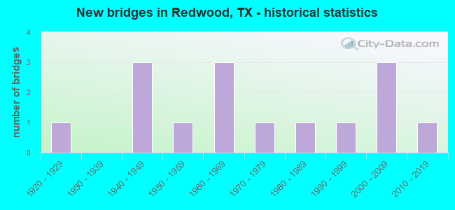
- New bridges - historical statistics
- 11920-1929
- 31940-1949
- 11950-1959
- 31960-1969
- 11970-1979
- 11980-1989
- 11990-1999
- 32000-2009
- 12010-2019

- Reconstructed bridges - Historical Statistics
- 31960-1969
- 01970-1979
- 21980-1989


- Bridge Condition - Deck
- 66.7%Good
- 33.3%Satisfactory

- Bridge Condition - Superstructure
- 66.7%Good
- 33.3%Satisfactory

- Bridge Condition - Substructure
- 66.7%Good
- 33.3%Fair

- Bridge Condition - Channel
- 6.7%Very good
- 20.0%Good
- 46.7%Satisfactory
- 26.7%Fair

- Bridge Condition - Culverts
- 58.3%Good
- 33.3%Satisfactory
- 8.3%Fair
Find on map >> Show street view
Structure Number: 141060036601001, Location: 2.8 MI S OF FM 3407 (Lat: 29.806247, Lng: -97.944464), Route carried "on" structure: State highway 123, Year Built: 1929, Year Reconstructed: 1974, Status: Open, Structure Length: 1.04m (3.41ft), Average Daily Traffic: 12,117 (year 2019), Truck Traffic: 10%, Average Future Daily Traffic: 21,811 (year 2039), Features Intersected: LITTLE COTTONWOOD CREEK
Minimum Vertical Clearance: 30+ m (98+ ft), Kilometerpoint: 23.144, Lanes on structure: 4, Base Highway Network: Yes, Owner: State Highway Agency, Approaching Roadway Width: 15.2m (49.9ft), Skew: 9 degrees, Material/Design: Concrete, Design/Construction: Culvert, Number Of Spans In Main Unit: 6, Length of Maximum Span: 1.5m (4.9ft), Curb-To-Curb Width: 25.6m (84.0ft), Out-to-Out Width: 26.0m (85.3ft)
Condition: Channel: Good, Culverts: Good, Operating Rating: 32.7 metric tons, Method Used To Determine Operating Rating: Field evaluation and documented engineering judgment, Inventory Rating: 24.5 metric tons, Method Used To Determine Inventory Rating: Field evaluation and documented engineering judgment, Structural Evaluation: Equal to present minimum criteria, Deck Geometry: Superior to present desirable criteria, Waterway Adequacy: Equal to present minimum criteria, Approach Roadway Alignment: Equal to present desirable criteria, Length Of Structure Improvement: 1.04m (3.41ft), Designated Inspection Frequency: Every 24 months, Inspection Date: December 2020, Deck Structure Type: Concrete Cast-file-Place, Wearing Surface/Protective System: Wearing Surface: Bituminous
Find on map >> Show street view
Structure Number: 150950036602038, Location: 1.5 MI S OF JCT FM 1979 (Lat: 29.749569, Lng: -97.948644), Route carried "on" structure: State highway 123, Year Built: 1948, Year Reconstructed: 1967, Status: Open, Structure Length: 29.26m (96.00ft), Average Daily Traffic: 8,871 (year 2020), Truck Traffic: 12%, Average Future Daily Traffic: 13,020 (year 2033), Design Load: H 20, Features Intersected: YORK CREEK
Minimum Vertical Clearance: 30+ m (98+ ft), Kilometerpoint: 6.146, Lanes on structure: 4, Owner: State Highway Agency, Approaching Roadway Width: 15.9m (52.2ft), Material/Design: Concrete continuous, Design/Construction: Slab, Number Of Spans In Main Unit: 35, Length of Maximum Span: 9.1m (29.9ft), Curb-To-Curb Width: 15.9m (52.2ft), Out-to-Out Width: 16.6m (54.5ft)
Condition: Deck: Satisfactory, Superstructure: Satisfactory, Substructure: Fair, Channel: Satisfactory, Operating Rating: 44.4 metric tons, Method Used To Determine Operating Rating: Load Factor (LF), Inventory Rating: 17.2 metric tons, Method Used To Determine Inventory Rating: Load Factor (LF), Structural Evaluation: Meets minimum limits, Deck Geometry: Meets minimum limits, Waterway Adequacy: Equal to present minimum criteria, Approach Roadway Alignment: Equal to present desirable criteria, Length Of Structure Improvement: 29.26m (96.00ft), Designated Inspection Frequency: Every 24 months, Inspection Date: September 2020, Deck Structure Type: Concrete Cast-file-Place, Wearing Surface/Protective System: Wearing Surface: Bituminous
Find on map >> Show street view
Structure Number: 150950036602043, Location: 0.2 MI N OF JCT FM 1978 (Lat: 29.799122, Lng: -97.945175), Route carried "on" structure: State highway 123, Year Built: 1948, Year Reconstructed: 1980, Status: Open, Structure Length: 0.88m (2.89ft), Average Daily Traffic: 10,953 (year 2020), Truck Traffic: 11%, Average Future Daily Traffic: 15,800 (year 2033), Design Load: H 20, Features Intersected: DRAW
Minimum Vertical Clearance: 30+ m (98+ ft), Kilometerpoint: 0.729, Lanes on structure: 2, Owner: State Highway Agency, Approaching Roadway Width: 15.9m (52.2ft), Material/Design: Concrete, Design/Construction: Culvert, Number Of Spans In Main Unit: 5, Length of Maximum Span: 1.5m (4.9ft)
Condition: Channel: Fair, Culverts: Satisfactory, Operating Rating: 39.9 metric tons, Method Used To Determine Operating Rating: Load Factor (LF), Inventory Rating: 23.6 metric tons, Method Used To Determine Inventory Rating: Load Factor (LF), Structural Evaluation: Somewhat better than minimum adequacy, Waterway Adequacy: Equal to present minimum criteria, Approach Roadway Alignment: Equal to present desirable criteria, Designated Inspection Frequency: Every 24 months, Inspection Date: August 2020
Find on map >> Show street view
Structure Number: 150950036602045, Location: 0.3 MI. S. OF JCT FM 1978 (Lat: 29.790953, Lng: -97.946056), Route carried "on" structure: State highway 123, Year Built: 1948, Year Reconstructed: 1980, Status: Open, Structure Length: 0.70m (2.30ft), Average Daily Traffic: 10,253 (year 2020), Truck Traffic: 12%, Average Future Daily Traffic: 14,450 (year 2033), Design Load: H 15, Features Intersected: DRAW
Minimum Vertical Clearance: 30+ m (98+ ft), Kilometerpoint: 1.619, Lanes on structure: 3, Owner: State Highway Agency, Approaching Roadway Width: 15.9m (52.2ft), Material/Design: Concrete, Design/Construction: Culvert, Number Of Spans In Main Unit: 4, Length of Maximum Span: 1.5m (4.9ft)
Condition: Channel: Fair, Culverts: Good, Operating Rating: 39.9 metric tons, Method Used To Determine Operating Rating: Load Factor (LF), Inventory Rating: 23.6 metric tons, Method Used To Determine Inventory Rating: Load Factor (LF), Structural Evaluation: Somewhat better than minimum adequacy, Waterway Adequacy: Equal to present minimum criteria, Approach Roadway Alignment: Equal to present desirable criteria, Designated Inspection Frequency: Every 24 months, Inspection Date: August 2020
Find on map >> Show street view
Structure Number: 15095009870101, Location: 0.60 MI N OF FM 1979 (Lat: 29.814042, Lng: -97.884106), Route carried "on" structure: State highway 621, Year Built: 2002, Status: Open, Structure Length: 1.16m (3.81ft), Average Daily Traffic: 3,261 (year 2020), Truck Traffic: 11%, Average Future Daily Traffic: 2,780 (year 2030), Design Load: HS 20, Features Intersected: DRAW
Minimum Vertical Clearance: 30+ m (98+ ft), Kilometerpoint: 0.966, Lanes on structure: 2, Owner: State Highway Agency, Approaching Roadway Width: 8.2m (26.9ft), Material/Design: Concrete, Design/Construction: Culvert, Number Of Spans In Main Unit: 6, Length of Maximum Span: 1.5m (4.9ft), Curb-To-Curb Width: 8.2m (26.9ft), Out-to-Out Width: 16.9m (55.4ft)
Condition: Channel: Satisfactory, Culverts: Satisfactory, Operating Rating: 54.4 metric tons, Method Used To Determine Operating Rating: Assigned rating based on Load Factor Design (LFD) reported in metric tons, Inventory Rating: 32.7 metric tons, Method Used To Determine Inventory Rating: Assigned rating based on Load Factor Design (LFD) reported in metric tons, Structural Evaluation: Equal to present minimum criteria, Deck Geometry: High priority of corrective action, Waterway Adequacy: Equal to present minimum criteria, Approach Roadway Alignment: Equal to present desirable criteria, Length Of Structure Improvement: 1.16m (3.81ft), Designated Inspection Frequency: Every 24 months, Inspection Date: August 2020, Bridge Improvement Cost: $2,000, Roadway Improvement Cost: $1,000, Total Project Cost: $3,000, Deck Structure Type: Concrete Cast-file-Place, Wearing Surface/Protective System: Wearing Surface: Bituminous
Find on map >> Show street view
Structure Number: 150950098701011, Location: 0.30 MI S OF FM 1979 (Lat: 29.813525, Lng: -97.858781), Route carried "on" structure: State highway 621, Year Built: 2002, Status: Open, Structure Length: 0.94m (3.08ft), Average Daily Traffic: 973 (year 2020), Truck Traffic: 11%, Average Future Daily Traffic: 2,780 (year 2030), Design Load: HS 20, Features Intersected: DRAW
Minimum Vertical Clearance: 30+ m (98+ ft), Kilometerpoint: 0.966, Lanes on structure: 2, Owner: State Highway Agency, Approaching Roadway Width: 8.2m (26.9ft), Material/Design: Concrete, Design/Construction: Culvert, Number Of Spans In Main Unit: 5, Length of Maximum Span: 1.5m (4.9ft), Curb-To-Curb Width: 8.2m (26.9ft), Out-to-Out Width: 16.9m (55.4ft)
Condition: Channel: Satisfactory, Culverts: Good, Operating Rating: 54.4 metric tons, Method Used To Determine Operating Rating: Assigned rating based on Load Factor Design (LFD) reported in metric tons, Inventory Rating: 32.7 metric tons, Method Used To Determine Inventory Rating: Assigned rating based on Load Factor Design (LFD) reported in metric tons, Structural Evaluation: Better than present minimum criteria, Deck Geometry: Somewhat better than minimum adequacy, Waterway Adequacy: Equal to present minimum criteria, Approach Roadway Alignment: Equal to present desirable criteria, Designated Inspection Frequency: Every 24 months, Inspection Date: August 2020, Deck Structure Type: Concrete Cast-file-Place, Wearing Surface/Protective System: Wearing Surface: Bituminous
Find on map >> Show street view
Structure Number: 150950143401003, Location: 5.2 MI E SH 123 (Lat: 29.752383, Lng: -97.890417), Route carried "on" structure: State highway 1339, Year Built: 1958, Year Reconstructed: 1971, Status: Open, Structure Length: 2.53m (8.30ft), Average Daily Traffic: 371 (year 2020), Truck Traffic: 4%, Average Future Daily Traffic: 340 (year 2033), Design Load: HS 20, Features Intersected: COTTONWOOD CREEK
Minimum Vertical Clearance: 30+ m (98+ ft), Kilometerpoint: 8.327, Lanes on structure: 2, Owner: State Highway Agency, Approaching Roadway Width: 7.3m (24.0ft), Skew: 4 degrees, Material/Design: Concrete, Design/Construction: Culvert, Number Of Spans In Main Unit: 9, Length of Maximum Span: 1.8m (5.9ft)
Condition: Channel: Fair, Culverts: Satisfactory, Operating Rating: 39.9 metric tons, Method Used To Determine Operating Rating: Load Factor (LF), Inventory Rating: 23.6 metric tons, Method Used To Determine Inventory Rating: Load Factor (LF), Structural Evaluation: Equal to present minimum criteria, Waterway Adequacy: Better than present minimum criteria, Approach Roadway Alignment: Equal to present desirable criteria, Designated Inspection Frequency: Every 24 months, Inspection Date: August 2020
Find on map >> Show street view
Structure Number: 150950143401004, Location: 4.20 MI E OF SH 123 (Lat: 29.745375, Lng: -97.904369), Route carried "on" structure: State highway 1339, Year Built: 1971, Status: Open, Structure Length: 0.98m (3.22ft), Average Daily Traffic: 371 (year 2020), Truck Traffic: 4%, Average Future Daily Traffic: 340 (year 2033), Design Load: HS 20, Features Intersected: DRAW
Minimum Vertical Clearance: 30+ m (98+ ft), Kilometerpoint: 6.780, Lanes on structure: 2, Owner: State Highway Agency, Approaching Roadway Width: 7.9m (25.9ft), Skew: 4 degrees, Material/Design: Concrete, Design/Construction: Culvert, Number Of Spans In Main Unit: 3, Length of Maximum Span: 2.1m (6.9ft), Curb-To-Curb Width: 8.5m (27.9ft), Out-to-Out Width: 10.4m (34.1ft)
Condition: Channel: Satisfactory, Culverts: Good, Operating Rating: 39.9 metric tons, Method Used To Determine Operating Rating: Load Factor (LF), Inventory Rating: 23.6 metric tons, Method Used To Determine Inventory Rating: Load Factor (LF), Structural Evaluation: Equal to present minimum criteria, Deck Geometry: Equal to present minimum criteria, Waterway Adequacy: Better than present minimum criteria, Approach Roadway Alignment: Equal to present desirable criteria, Designated Inspection Frequency: Every 24 months, Inspection Date: September 2020, Deck Structure Type: Concrete Cast-file-Place, Wearing Surface/Protective System: Wearing Surface: Bituminous
Find on map >> Show street view
Structure Number: 150950189702001, Location: 1.54 MI SW OF FM 621 (Lat: 29.808900, Lng: -97.913014), Route carried "on" structure: State highway 1978, Year Built: 1988, Status: Open, Structure Length: 2.71m (8.89ft), Average Daily Traffic: 2,097 (year 2020), Truck Traffic: 23%, Average Future Daily Traffic: 2,870 (year 2033), Design Load: HS 20, Features Intersected: LITTLE COTTONWOOD CREEK
Minimum Vertical Clearance: 30+ m (98+ ft), Kilometerpoint: 5.179, Lanes on structure: 2, Owner: State Highway Agency, Approaching Roadway Width: 6.7m (22.0ft), Skew: 4 degrees, Material/Design: Concrete, Design/Construction: Culvert, Number Of Spans In Main Unit: 6, Length of Maximum Span: 3.0m (9.8ft), Curb-To-Curb Width: 9.1m (29.9ft), Out-to-Out Width: 9.8m (32.2ft)
Condition: Channel: Satisfactory, Culverts: Good, Operating Rating: 39.9 metric tons, Method Used To Determine Operating Rating: Load Factor (LF), Inventory Rating: 23.6 metric tons, Method Used To Determine Inventory Rating: Load Factor (LF), Structural Evaluation: Equal to present minimum criteria, Deck Geometry: Meets minimum limits, Waterway Adequacy: Better than present minimum criteria, Approach Roadway Alignment: Equal to present minimum criteria, Designated Inspection Frequency: Every 48 months, Inspection Date: September 2018, Deck Structure Type: Concrete Cast-file-Place, Wearing Surface/Protective System: Wearing Surface: Bituminous
Find on map >> Show street view
Structure Number: 150950189702002, Location: 0.4 MI E OF SH 123 (Lat: 29.797206, Lng: -97.938450), Route carried "on" structure: State highway 1978, Year Built: 1998, Status: Open, Structure Length: 1.43m (4.69ft), Average Daily Traffic: 2,097 (year 2020), Truck Traffic: 23%, Average Future Daily Traffic: 2,870 (year 2033), Design Load: HS 20, Features Intersected: LONG CREEK
Minimum Vertical Clearance: 30+ m (98+ ft), Kilometerpoint: 2.335, Lanes on structure: 2, Owner: State Highway Agency, Approaching Roadway Width: 7.3m (24.0ft), Material/Design: Concrete, Design/Construction: Culvert, Number Of Spans In Main Unit: 5, Length of Maximum Span: 2.4m (7.9ft), Curb-To-Curb Width: 9.5m (31.2ft), Out-to-Out Width: 10.2m (33.5ft)
Condition: Channel: Satisfactory, Culverts: Good, Operating Rating: 39.9 metric tons, Method Used To Determine Operating Rating: Load Factor (LF), Inventory Rating: 23.6 metric tons, Method Used To Determine Inventory Rating: Load Factor (LF), Structural Evaluation: Equal to present minimum criteria, Deck Geometry: Meets minimum limits, Waterway Adequacy: Better than present minimum criteria, Approach Roadway Alignment: Equal to present desirable criteria, Designated Inspection Frequency: Every 48 months, Inspection Date: September 2018, Deck Structure Type: Concrete Cast-file-Place, Wearing Surface/Protective System: Wearing Surface: Bituminous
Find on map >> Show street view
Structure Number: 150950189803002, Location: 1.1 MI FR SH 123 (Lat: 29.771336, Lng: -97.929350), Route carried "on" structure: State highway 1979, Year Built: 1967, Status: Open, Structure Length: 0.98m (3.22ft), Average Daily Traffic: 1,253 (year 2020), Truck Traffic: 10%, Average Future Daily Traffic: 1,730 (year 2033), Design Load: H 20, Features Intersected: LONG CREEK
Minimum Vertical Clearance: 30+ m (98+ ft), Kilometerpoint: 1.778, Lanes on structure: 2, Owner: State Highway Agency, Approaching Roadway Width: 6.1m (20.0ft), Material/Design: Concrete, Design/Construction: Culvert, Number Of Spans In Main Unit: 3, Length of Maximum Span: 3.0m (9.8ft), Curb-To-Curb Width: 7.9m (25.9ft), Out-to-Out Width: 8.9m (29.2ft)
Condition: Channel: Satisfactory, Culverts: Satisfactory, Operating Rating: 39.9 metric tons, Method Used To Determine Operating Rating: Load Factor (LF), Inventory Rating: 23.6 metric tons, Method Used To Determine Inventory Rating: Load Factor (LF), Structural Evaluation: Equal to present minimum criteria, Deck Geometry: Meets minimum limits, Waterway Adequacy: Equal to present minimum criteria, Approach Roadway Alignment: Equal to present desirable criteria, Length Of Structure Improvement: 0.98m (3.22ft), Designated Inspection Frequency: Every 24 months, Inspection Date: August 2020, Bridge Improvement Cost: $1,000, Total Project Cost: $1,000, Deck Structure Type: Concrete Cast-file-Place, Wearing Surface/Protective System: Wearing Surface: Bituminous
Find on map >> Show street view
Structure Number: 150950189803003, Location: 3.3 MI E SH 123 (Lat: 29.783650, Lng: -97.898533), Route carried "on" structure: State highway 1979, Year Built: 1967, Status: Open, Structure Length: 1.10m (3.61ft), Average Daily Traffic: 773 (year 2020), Truck Traffic: 10%, Average Future Daily Traffic: 1,000 (year 2033), Design Load: H 20, Features Intersected: LITTLE COTTONWOOD CREEK
Minimum Vertical Clearance: 30+ m (98+ ft), Kilometerpoint: 5.309, Lanes on structure: 2, Owner: State Highway Agency, Approaching Roadway Width: 6.1m (20.0ft), Skew: 3 degrees, Material/Design: Concrete, Design/Construction: Culvert, Number Of Spans In Main Unit: 3, Length of Maximum Span: 3.0m (9.8ft), Curb-To-Curb Width: 6.1m (20.0ft), Out-to-Out Width: 8.9m (29.2ft)
Condition: Channel: Good, Culverts: Good, Operating Rating: 39.9 metric tons, Method Used To Determine Operating Rating: Load Factor (LF), Inventory Rating: 23.6 metric tons, Method Used To Determine Inventory Rating: Load Factor (LF), Structural Evaluation: Equal to present minimum criteria, Deck Geometry: High priority of corrective action, Waterway Adequacy: Equal to present minimum criteria, Approach Roadway Alignment: Equal to present desirable criteria, Length Of Structure Improvement: 1.10m (3.61ft), Designated Inspection Frequency: Every 24 months, Inspection Date: August 2020, Bridge Improvement Cost: $1,000, Total Project Cost: $1,000, Deck Structure Type: Concrete Cast-file-Place, Wearing Surface/Protective System: Wearing Surface: Bituminous
Find on map >> Show street view
Structure Number: 150950189803004, Location: 3.9 MI E SH 123 (Lat: 29.790381, Lng: -97.892919), Route carried "on" structure: State highway 1979, Year Built: 1967, Status: Open, Structure Length: 1.16m (3.81ft), Average Daily Traffic: 773 (year 2020), Truck Traffic: 10%, Average Future Daily Traffic: 1,000 (year 2033), Design Load: H 20, Features Intersected: COTTONWOOD CREEK
Minimum Vertical Clearance: 30+ m (98+ ft), Kilometerpoint: 6.259, Lanes on structure: 2, Owner: State Highway Agency, Approaching Roadway Width: 6.1m (20.0ft), Material/Design: Concrete, Design/Construction: Culvert, Number Of Spans In Main Unit: 4, Length of Maximum Span: 2.7m (8.9ft), Curb-To-Curb Width: 6.7m (22.0ft), Out-to-Out Width: 8.9m (29.2ft)
Condition: Channel: Fair, Culverts: Fair, Operating Rating: 39.9 metric tons, Method Used To Determine Operating Rating: Load Factor (LF), Inventory Rating: 23.6 metric tons, Method Used To Determine Inventory Rating: Load Factor (LF), Structural Evaluation: Somewhat better than minimum adequacy, Deck Geometry: Meets minimum limits, Waterway Adequacy: Equal to present minimum criteria, Approach Roadway Alignment: Equal to present desirable criteria, Length Of Structure Improvement: 1.16m (3.81ft), Designated Inspection Frequency: Every 24 months, Inspection Date: August 2020, Bridge Improvement Cost: $67,000, Roadway Improvement Cost: $7,000, Total Project Cost: $100,000, Deck Structure Type: Concrete Cast-file-Place, Wearing Surface/Protective System: Wearing Surface: Bituminous
Find on map >> Show street view
Structure Number: 150950AA0154001, Location: 0.35 MI E OF SH 123 (Lat: 29.753042, Lng: -97.942242), Route carried "on" structure: County highway , Year Built: 2007, Status: Open, Structure Length: 1.98m (6.50ft), Average Daily Traffic: 100 (year 2010), Average Future Daily Traffic: 200 (year 2030), Design Load: HS 20, Features Intersected: YORK CREEK TRIBUTARY, Facility Carried by Structure: DREIBRODT RD
Minimum Vertical Clearance: 30+ m (98+ ft), Kilometerpoint: 4.023, Lanes on structure: 2, Owner: County Highway Agency, Approaching Roadway Width: 6.7m (22.0ft), Material/Design: Steel, Design/Construction: Stringer/Multi-beam, Number Of Spans In Main Unit: 1, Length of Maximum Span: 18.9m (62.0ft), Curb-To-Curb Width: 8.5m (27.9ft), Out-to-Out Width: 8.7m (28.5ft)
Condition: Deck: Good, Superstructure: Good, Substructure: Good, Channel: Good, Operating Rating: 54.4 metric tons, Method Used To Determine Operating Rating: Assigned rating based on Load Factor Design (LFD) reported in metric tons, Inventory Rating: 32.7 metric tons, Method Used To Determine Inventory Rating: Assigned rating based on Load Factor Design (LFD) reported in metric tons, Structural Evaluation: Better than present minimum criteria, Deck Geometry: Better than present minimum criteria, Waterway Adequacy: Equal to present minimum criteria, Approach Roadway Alignment: Equal to present desirable criteria, Length Of Structure Improvement: 1.46m (4.79ft), Designated Inspection Frequency: Every 24 months, Inspection Date: May 2021, Bridge Improvement Cost: $4,000, Roadway Improvement Cost: $1,000, Total Project Cost: $5,000, Deck Structure Type: Concrete Cast-file-Place
Find on map >> Show street view
Structure Number: 150950AA0154003, Location: 1.20 MI. E OF SH 123 (Lat: 29.753339, Lng: -97.929725), Route carried "on" structure: County highway , Year Built: 2015, Status: Open, Structure Length: 1.31m (4.30ft), Average Daily Traffic: 100 (year 2010), Average Future Daily Traffic: 200 (year 2030), Design Load: HS 20, Features Intersected: LONG CREEK, Facility Carried by Structure: DREIBRODT RD
Minimum Vertical Clearance: 30+ m (98+ ft), Kilometerpoint: 5.311, Lanes on structure: 2, Owner: County Highway Agency, Approaching Roadway Width: 7.0m (23.0ft), Material/Design: Steel, Design/Construction: Stringer/Multi-beam, Number Of Spans In Main Unit: 1, Length of Maximum Span: 12.5m (41.0ft), Curb-To-Curb Width: 8.5m (27.9ft), Out-to-Out Width: 8.5m (27.9ft)
Condition: Deck: Good, Superstructure: Good, Substructure: Good, Channel: Very good, Operating Rating: 54.4 metric tons, Method Used To Determine Operating Rating: Assigned rating based on Load Factor Design (LFD) reported in metric tons, Inventory Rating: 32.7 metric tons, Method Used To Determine Inventory Rating: Assigned rating based on Load Factor Design (LFD) reported in metric tons, Structural Evaluation: Better than present minimum criteria, Deck Geometry: Better than present minimum criteria, Waterway Adequacy: Equal to present minimum criteria, Approach Roadway Alignment: Equal to present minimum criteria, Length Of Structure Improvement: 1.31m (4.30ft), Designated Inspection Frequency: Every 24 months, Inspection Date: May 2021, Deck Structure Type: Concrete Cast-file-Place