Bridge Statistics for Ravena, New York (NY)
Condition, Traffic, Stress, Structural Evaluation, Project Costs
- National Bridge Inventory (NBI) Statistics
- 11Number of bridges
- 121ft / 37.1mTotal length
- $19,086,000Total costs
- 46,646Total average daily traffic
- 8,775Total average daily truck traffic
- National Bridge Inventory (NBI) Registered Bridges for Ravena
- No street view available for this location
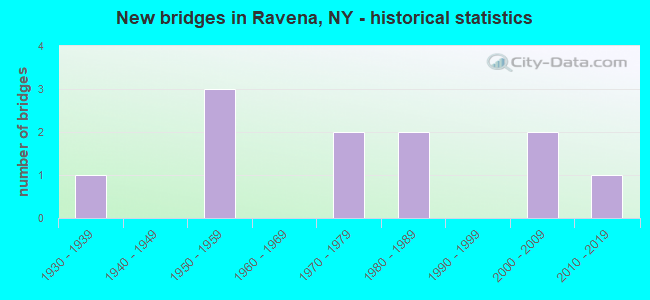
- New bridges - historical statistics
- 11930-1939
- 31950-1959
- 21970-1979
- 21980-1989
- 22000-2009
- 12010-2019

- Reconstructed bridges - Historical Statistics
- 21980-1989
- 11990-1999


- Bridge Condition - Deck
- 12.5%Very good
- 25.0%Good
- 62.5%Fair

- Bridge Condition - Superstructure
- 11.1%Excellent
- 22.2%Very good
- 22.2%Good
- 33.3%Satisfactory
- 11.1%Poor

- Bridge Condition - Substructure
- 22.2%Excellent
- 11.1%Very good
- 11.1%Good
- 33.3%Satisfactory
- 22.2%Fair

- Bridge Condition - Channel
- 33.3%Good
- 33.3%Satisfactory
- 16.7%Fair
- 16.7%Poor
Find on map >> Show street view
Structure Number: 100756, Location: 2.7 MIS JCT RTS 9W & 396 (Lat: 42.511408, Lng: -73.816736), Route carried "on" structure: US 9W, Year Built: 1985, Status: Open, Structure Length: 3.35m (10.99ft), Average Daily Traffic: 6,265 (year 2018), Truck Traffic: 9%, Average Future Daily Traffic: 6,294 (year 2040), Design Load: HS 20, Features Intersected: COEYMANS CREEK
Minimum Vertical Clearance: 30+ m (98+ ft), Kilometerpoint: 5.680, Lanes on structure: 2, Base Highway Network: Yes, Owner: State Highway Agency, Approaching Roadway Width: 12.2m (40.0ft), Material/Design: Prestressed concrete, Design/Construction: Box Beam or Girders - Multiple, Number Of Spans In Main Unit: 1, Length of Maximum Span: 32.6m (107.0ft), Curb-To-Curb Width: 12.2m (40.0ft), Out-to-Out Width: 13.0m (42.7ft)
Condition: Deck: Fair, Superstructure: Poor, Substructure: Good, Channel: Good, Operating Rating: 85.9 metric tons, Method Used To Determine Operating Rating: Load and Resistance Factor Rating (LRFR) rating reported by rating factor(RF) method using HL-93 loadings, Inventory Rating: 60.9 metric tons, Method Used To Determine Inventory Rating: Load and Resistance Factor Rating (LRFR) rating reported by rating factor(RF) method using HL-93 loadings, Structural Evaluation: Meets minimum limits, Deck Geometry: Somewhat better than minimum adequacy, Waterway Adequacy: Somewhat better than minimum adequacy, Approach Roadway Alignment: Equal to present desirable criteria, Length Of Structure Improvement: 3.35m (10.99ft), Designated Inspection Frequency: Every 24 months, Inspection Date: May 2021, Bridge Improvement Cost: $1,214,000, Roadway Improvement Cost: $711,000, Total Project Cost: $1,924,000 ( Estimate for 2021), Deck Structure Type: Concrete Cast-file-Place, Wearing Surface/Protective System: Wearing Surface: Integral Concrete, Deck Protection: Epoxy Coated Reinforcing
Find on map >> Show street view
Structure Number: 103803, Location: 2.6 MI W JCT RTS 9W & 143 (Lat: 42.467839, Lng: -73.855964), Route carried "on" structure: State highway 143, Year Built: 2003, Status: Open, Structure Length: 2.62m (8.60ft), Average Daily Traffic: 2,270 (year 2017), Truck Traffic: 6%, Average Future Daily Traffic: 3,178 (year 2037), Design Load: HS 25 or greater, Features Intersected: HANNACROIS CREEK
Minimum Vertical Clearance: 30+ m (98+ ft), Kilometerpoint: 23.910, Lanes on structure: 2, Base Highway Network: Yes, Owner: State Highway Agency, Approaching Roadway Width: 9.1m (29.9ft), Skew: 2 degrees, Material/Design: Prestressed concrete, Design/Construction: Box Beam or Girders - Multiple, Number Of Spans In Main Unit: 1, Length of Maximum Span: 25.2m (82.7ft), Curb-To-Curb Width: 9.1m (29.9ft), Out-to-Out Width: 10.1m (33.1ft)
Condition: Deck: Good, Superstructure: Very good, Substructure: Excellent, Channel: Good, Operating Rating: 69.9 metric tons, Method Used To Determine Operating Rating: Load Factor (LF), Inventory Rating: 41.7 metric tons, Method Used To Determine Inventory Rating: Load Factor (LF), Structural Evaluation: Equal to present desirable criteria, Deck Geometry: Meets minimum limits, Waterway Adequacy: Equal to present minimum criteria, Approach Roadway Alignment: Equal to present desirable criteria, Length Of Structure Improvement: 2.62m (8.60ft), Designated Inspection Frequency: Every 24 months, Inspection Date: March 2021, Bridge Improvement Cost: $841,000, Roadway Improvement Cost: $493,000, Total Project Cost: $1,334,000 ( Estimate for 2021), Deck Structure Type: Concrete Cast-file-Place, Wearing Surface/Protective System: Wearing Surface: Monolithic Concrete, Deck Protection: Epoxy Coated Reinforcing
Find on map >> Show street view
Structure Number: 227032, Location: .1MI W of inters W/RT143 (Lat: 42.463300, Lng: -73.847519), Route carried "on" structure: Other road , Year Built: 1939, Year Reconstructed: 1995, Status: Open, Structure Length: 1.37m (4.49ft), Average Daily Traffic: 86 (year 2019), Truck Traffic: 8%, Average Future Daily Traffic: 120 (year 2039), Features Intersected: HANNACROIS CK, Facility Carried by Structure: MARSHALL ROAD
Minimum Vertical Clearance: 30+ m (98+ ft), Kilometerpoint: 1.271, Lanes on structure: 1, Owner: Town or Township Highway Agency, Approaching Roadway Width: 4.3m (14.1ft), Material/Design: Prestressed concrete, Design/Construction: Tee Beam, Number Of Spans In Main Unit: 1, Length of Maximum Span: 13.4m (44.0ft), Curb-To-Curb Width: 4.3m (14.1ft), Out-to-Out Width: 4.9m (16.1ft)
Condition: Superstructure: Satisfactory, Substructure: Satisfactory, Channel: Satisfactory, Operating Rating: 58.3 metric tons, Method Used To Determine Operating Rating: Field evaluation and documented engineering judgment, Inventory Rating: 24.1 metric tons, Method Used To Determine Inventory Rating: Field evaluation and documented engineering judgment, Structural Evaluation: Equal to present minimum criteria, Deck Geometry: Equal to present minimum criteria, Waterway Adequacy: Equal to present minimum criteria, Approach Roadway Alignment: High priority of corrective action, Length Of Structure Improvement: 1.37m (4.49ft), Designated Inspection Frequency: Every 24 months, Inspection Date: October 2021, Bridge Improvement Cost: $258,000, Roadway Improvement Cost: $151,000, Total Project Cost: $408,000 ( Estimate for 2021)
Find on map >> Show street view
Structure Number: 330103, Location: 1.0 MI SW OF SELKIRK (Lat: 42.512756, Lng: -73.808433), Route carried "on" structure: Other road , Year Built: 1975, Status: Open, Structure Length: 2.35m (7.71ft), Average Daily Traffic: 114 (year 2019), Truck Traffic: 5%, Average Future Daily Traffic: 160 (year 2039), Features Intersected: COEYMANS CREEK, Facility Carried by Structure: OLD RAVENA ROAD
Minimum Vertical Clearance: 30+ m (98+ ft), Kilometerpoint: 1.175, Lanes on structure: 2, Owner: County Highway Agency, Approaching Roadway Width: 5.8m (19.0ft), Material/Design: Prestressed concrete, Design/Construction: Tee Beam, Number Of Spans In Main Unit: 1, Length of Maximum Span: 22.8m (74.8ft), Curb-To-Curb Width: 7.0m (23.0ft), Out-to-Out Width: 7.7m (25.3ft)
Condition: Deck: Fair, Superstructure: Satisfactory, Substructure: Satisfactory, Channel: Satisfactory, Operating Rating: 88.9 metric tons, Method Used To Determine Operating Rating: Field evaluation and documented engineering judgment, Inventory Rating: 32.7 metric tons, Method Used To Determine Inventory Rating: Field evaluation and documented engineering judgment, Structural Evaluation: Equal to present minimum criteria, Deck Geometry: Meets minimum limits, Waterway Adequacy: Meets minimum limits, Approach Roadway Alignment: Equal to present minimum criteria, Length Of Structure Improvement: 2.34m (7.68ft), Designated Inspection Frequency: Every 24 months, Inspection Date: May 2021, Bridge Improvement Cost: $636,000, Roadway Improvement Cost: $373,000, Total Project Cost: $1,009,000 ( Estimate for 2021), Deck Structure Type: Concrete Cast-file-Place, Wearing Surface/Protective System: Wearing Surface: Bituminous
Find on map >> Show street view
Structure Number: 33011, Location: 3 MI W VILLAGE OF RAVENA (Lat: 42.471256, Lng: -73.877394), Route carried "on" structure: County highway , Year Built: 1955, Year Reconstructed: 1991, Status: Open, Structure Length: 1.65m (5.41ft), Average Daily Traffic: 291 (year 2020), Truck Traffic: 7%, Average Future Daily Traffic: 407 (year 2040), Design Load: HS 25 or greater, Features Intersected: HANNACROIS CREEK, Facility Carried by Structure: THOMPKINS R CR106
Minimum Vertical Clearance: 30+ m (98+ ft), Kilometerpoint: 0.338, Lanes on structure: 2, Owner: County Highway Agency, Approaching Roadway Width: 9.1m (29.9ft), Skew: 1 degrees, Material/Design: Steel, Design/Construction: Stringer/Multi-beam, Number Of Spans In Main Unit: 1, Length of Maximum Span: 15.8m (51.8ft), Curb-To-Curb Width: 9.1m (29.9ft), Out-to-Out Width: 9.8m (32.2ft)
Condition: Deck: Good, Superstructure: Satisfactory, Substructure: Fair, Channel: Poor, Operating Rating: 56.7 metric tons, Method Used To Determine Operating Rating: Load and Resistance Factor Rating (LRFR) rating reported by rating factor(RF) method using HL-93 loadings, Inventory Rating: 43.7 metric tons, Method Used To Determine Inventory Rating: Load and Resistance Factor Rating (LRFR) rating reported by rating factor(RF) method using HL-93 loadings, Structural Evaluation: Somewhat better than minimum adequacy, Deck Geometry: Equal to present minimum criteria, Waterway Adequacy: Superior to present desirable criteria, Approach Roadway Alignment: Equal to present minimum criteria, Length Of Structure Improvement: 1.64m (5.38ft), Designated Inspection Frequency: Every 24 months, Inspection Date: April 2020, Bridge Improvement Cost: $541,000, Roadway Improvement Cost: $317,000, Total Project Cost: $858,000 ( Estimate for 2021), Deck Structure Type: Concrete Cast-file-Place, Wearing Surface/Protective System: Wearing Surface: Integral Concrete, Deck Protection: Epoxy Coated Reinforcing
Find on map >> Show street view
Structure Number: 330292, Location: 1.5 MI SE S BETHLEHEM (Lat: 42.519289, Lng: -73.821331), Route carried "on" structure: Other road , Year Built: 1970, Status: Posted for load, Structure Length: 2.13m (6.99ft), Average Daily Traffic: 89 (year 2016), Truck Traffic: 6%, Average Future Daily Traffic: 125 (year 2036), Features Intersected: COEYMANS CREEK, Facility Carried by Structure: KRUEGER ROAD
Minimum Vertical Clearance: 30+ m (98+ ft), Kilometerpoint: 0.499, Lanes on structure: 1, Owner: County Highway Agency, Approaching Roadway Width: 4.9m (16.1ft), Material/Design: Prestressed concrete, Design/Construction: Tee Beam, Number Of Spans In Main Unit: 1, Length of Maximum Span: 19.8m (65.0ft), Curb-To-Curb Width: 4.8m (15.7ft), Out-to-Out Width: 4.8m (15.7ft)
Condition: Deck: Fair, Superstructure: Good, Substructure: Satisfactory, Channel: Fair, Operating Rating: 18.1 metric tons, Method Used To Determine Operating Rating: Field evaluation and documented engineering judgment, Inventory Rating: 18.1 metric tons, Method Used To Determine Inventory Rating: Field evaluation and documented engineering judgment, Structural Evaluation: Somewhat better than minimum adequacy, Deck Geometry: Equal to present desirable criteria, Waterway Adequacy: Equal to present desirable criteria, Approach Roadway Alignment: Meets minimum limits, Bridge Posting: Required (Relationship of Operating Rating to Maximum Legal Load: > 39.9% below), Length Of Structure Improvement: 2.13m (6.99ft), Designated Inspection Frequency: Every 12 months, Inspection Date: April 2021, Bridge Improvement Cost: $372,000, Roadway Improvement Cost: $218,000, Total Project Cost: $590,000 ( Estimate for 2021), Deck Structure Type: Other, Wearing Surface/Protective System: Wearing Surface: Bituminous
Find on map >> Show street view
Structure Number: 330297, Location: 1 MILE NORTH OF RAVENA (Lat: 42.508814, Lng: -73.814944), Route carried "on" structure: City street , Year Built: 2005, Status: Open, Structure Length: 6.13m (20.11ft), Average Daily Traffic: 114 (year 2019), Truck Traffic: 5%, Average Future Daily Traffic: 160 (year 2039), Design Load: HS 25 or greater, Features Intersected: CSX TRANS/RVR LNE, Facility Carried by Structure: OLD RAVENA ROAD
Minimum Vertical Clearance: 30+ m (98+ ft), Kilometerpoint: 0.386, Lanes on structure: 2, Owner: Railroad, Maintenance Responsibility: Town or Township Highway Agency, Approaching Roadway Width: 7.3m (24.0ft), Material/Design: Steel, Design/Construction: Stringer/Multi-beam, Number Of Spans In Main Unit: 1, Length of Maximum Span: 60.0m (196.9ft), Curb-To-Curb Width: 7.2m (23.6ft), Out-to-Out Width: 8.2m (26.9ft)
Condition: Deck: Fair, Superstructure: Very good, Substructure: Very good, Operating Rating: 31.1 metric tons, Method Used To Determine Operating Rating: Load and Resistance Factor Rating (LRFR) rating reported by rating factor(RF) method using HL-93 loadings, Inventory Rating: 24.0 metric tons, Method Used To Determine Inventory Rating: Load and Resistance Factor Rating (LRFR) rating reported by rating factor(RF) method using HL-93 loadings, Structural Evaluation: Equal to present minimum criteria, Deck Geometry: Meets minimum limits, Underclear: Superior to present desirable criteria, Approach Roadway Alignment: Equal to present desirable criteria, Length Of Structure Improvement: 6.12m (20.08ft), Designated Inspection Frequency: Every 24 months, Inspection Date: August 2021, Bridge Improvement Cost: $1,207,000, Roadway Improvement Cost: $707,000, Total Project Cost: $1,914,000 ( Estimate for 2021), Deck Structure Type: Concrete Cast-file-Place, Wearing Surface/Protective System: Wearing Surface: Integral Concrete, Deck Protection: Epoxy Coated Reinforcing
Find on map >> Show street view
Structure Number: 330298, Location: 1 MILE SW OF SELKIRK (Lat: 42.523814, Lng: -73.806936), Route carried "on" structure: City street , Year Built: 2011, Status: Open, Structure Length: 12.98m (42.59ft), Average Daily Traffic: 114 (year 2019), Truck Traffic: 5%, Average Future Daily Traffic: 160 (year 2039), Design Load: HS 25 or greater, Features Intersected: CSX TRANSPRTATION, Facility Carried by Structure: OLD RAVENA ROAD
Minimum Vertical Clearance: 30+ m (98+ ft), Kilometerpoint: 1.384, Lanes on structure: 2, Owner: Town or Township Highway Agency, Approaching Roadway Width: 8.8m (28.9ft), Skew: 6 degrees, Material/Design: Steel continuous, Design/Construction: Stringer/Multi-beam, Number Of Spans In Main Unit: 3, Length of Maximum Span: 62.8m (206.0ft), Curb-To-Curb Width: 9.0m (29.5ft), Out-to-Out Width: 10.0m (32.8ft)
Condition: Deck: Very good, Superstructure: Excellent, Substructure: Excellent, Operating Rating: 68.9 metric tons, Method Used To Determine Operating Rating: Load Factor (LF), Inventory Rating: 40.8 metric tons, Method Used To Determine Inventory Rating: Load Factor (LF), Structural Evaluation: Superior to present desirable criteria, Deck Geometry: Equal to present minimum criteria, Underclear: Superior to present desirable criteria, Approach Roadway Alignment: Equal to present minimum criteria, Length Of Structure Improvement: 12.98m (42.59ft), Designated Inspection Frequency: Every 24 months, Inspection Date: August 2021, Bridge Improvement Cost: $3,187,000, Roadway Improvement Cost: $1,866,000, Total Project Cost: $5,053,000 ( Estimate for 2021), Deck Structure Type: Concrete Cast-file-Place, Wearing Surface/Protective System: Wearing Surface: Integral Concrete, Deck Protection: Epoxy Coated Reinforcing
Find on map >> Show street view
Structure Number: 5038059, Location: JCT I87 & RTE 143 (Lat: 42.472450, Lng: -73.806158), Route carried "on" structure: Interstate 87, Year Built: 1952, Year Reconstructed: 1994, Status: Open, Structure Length: 4.51m (14.80ft), Average Daily Traffic: 28,681 (year 2020), Truck Traffic: 28%, Average Future Daily Traffic: 45,450 (year 2040), Design Load: HS 20+Mod, Features Intersected: RTE 143
Minimum Vertical Clearance: 30+ m (98+ ft), Kilometerpoint: 1.142, Lanes on structure: 4, Lanes under structure: 2, Base Highway Network: Yes, Toll: On Interstate toll segment, Owner: State Toll Authority, Approaching Roadway Width: 36.6m (120.1ft), Skew: 30 degrees, Material/Design: Steel, Design/Construction: Stringer/Multi-beam, Number Of Spans In Main Unit: 3, Length of Maximum Span: 21.6m (70.9ft), Curb-To-Curb Width: 36.6m (120.1ft), Out-to-Out Width: 37.8m (124.0ft)
Condition: Deck: Fair, Superstructure: Good, Substructure: Fair, Operating Rating: 61.7 metric tons, Method Used To Determine Operating Rating: Load Factor (LF), Inventory Rating: 37.2 metric tons, Method Used To Determine Inventory Rating: Load Factor (LF), Structural Evaluation: Somewhat better than minimum adequacy, Deck Geometry: Superior to present desirable criteria, Underclear: Meets minimum limits, Approach Roadway Alignment: Equal to present desirable criteria, Length Of Structure Improvement: 4.51m (14.80ft), Designated Inspection Frequency: Every 24 months, Inspection Date: April 2020, Bridge Improvement Cost: $3,782,000, Roadway Improvement Cost: $2,215,000, Total Project Cost: $5,996,000 ( Estimate for 2021), Deck Structure Type: Concrete Cast-file-Place, Wearing Surface/Protective System: Wearing Surface: Bituminous, Membrane: Preformed Fabric, Deck Protection: Galvanized Reinforcing
Find on map >> Show street view
Structure Number: 5038059, Location: JCT I87 & RTE 143 (Lat: 42.472450, Lng: -73.806158), Route carried "under" structure: State highway 143, Year Built: 1952, Structure Length: 0. m, Average Daily Traffic: 4,611 (year 2009), Features Intersected: RTE 143, Facility Carried by Structure: RTE I87
Minimum Vertical Clearance: 4.37m (14.34ft), Kilometerpoint: 29.042, Lanes on structure: 4, Lanes under structure: 2, Material/Design: Steel, Design/Construction: Stringer/Multi-beam, Length of Maximum Span: 21.6m (70.9ft)
Find on map >> Show street view
Structure Number: 703804, Location: JCT RT 143 & CSX TRANSPRT (Lat: 42.472036, Lng: -73.808983), Route carried "under" structure: State highway 143, Year Built: 1985, Structure Length: 0. m, Average Daily Traffic: 4,011 (year 2002), Features Intersected: RTE 143, Facility Carried by Structure: CSX TRANSPRTATION
Minimum Vertical Clearance: 4.65m (15.26ft), Kilometerpoint: 28.785, Lanes under structure: 2, Material/Design: Steel, Design/Construction: Girder and Floorbeam System, Length of Maximum Span: 29.2m (95.8ft)