Bridge Statistics for Ramah, Colorado (CO)
Condition, Traffic, Stress, Structural Evaluation, Project Costs
- National Bridge Inventory (NBI) Statistics
- 12Number of bridges
- 95ft / 29.3mTotal length
- 23,978Total average daily traffic
- 2,847Total average daily truck traffic
- 28,546Total future (year 2040) average daily traffic
- National Bridge Inventory (NBI) Registered Bridges for Ramah
- No street view available for this location
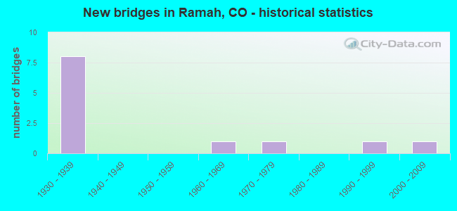
- New bridges - historical statistics
- 81930-1939
- 11960-1969
- 11970-1979
- 11990-1999
- 12000-2009


- Bridge Condition - Deck
- 27.3%Good
- 72.7%Satisfactory

- Bridge Condition - Superstructure
- 9.1%Very good
- 9.1%Good
- 54.5%Satisfactory
- 27.3%Fair

- Bridge Condition - Substructure
- 18.2%Good
- 54.5%Satisfactory
- 27.3%Fair

- Bridge Condition - Channel
- 91.7%Very good
- 8.3%Good
Find on map >> Show street view
Structure Number: EPC0004-08.90A, Location: 1.2 MI WEST OF RAMAH (Lat: 39.114444, Lng: -104.183889), Route carried "on" structure: County highway , Year Built: 2000, Status: Open, Structure Length: 4.61m (15.12ft), Average Daily Traffic: 27 (year 2020), Average Future Daily Traffic: 36 (year 2040), Features Intersected: BIG SANDY CREEK, Facility Carried by Structure: RAMAH ROAD
Minimum Vertical Clearance: 30+ m (98+ ft), Kilometerpoint: 13.892, Lanes on structure: 2, Owner: County Highway Agency, Approaching Roadway Width: 7.6m (24.9ft), Material/Design: Steel continuous, Design/Construction: Stringer/Multi-beam, Number Of Spans In Main Unit: 5, Length of Maximum Span: 8.7m (28.5ft), Curb-To-Curb Width: 9.1m (29.9ft), Out-to-Out Width: 9.2m (30.2ft)
Condition: Deck: Good, Superstructure: Good, Substructure: Good, Channel: Very good, Operating Rating: 68.1 metric tons, Method Used To Determine Operating Rating: Load Factor (LF), Inventory Rating: 40.8 metric tons, Method Used To Determine Inventory Rating: Load Factor (LF), Structural Evaluation: Better than present minimum criteria, Deck Geometry: Better than present minimum criteria, Waterway Adequacy: Equal to present desirable criteria, Approach Roadway Alignment: Equal to present desirable criteria, Designated Inspection Frequency: Every 24 months, Inspection Date: Febuary 2020, Deck Structure Type: Corrugated Steel, Wearing Surface/Protective System: Wearing Surface: Bituminous
Find on map >> Show street view
Structure Number: EPC0006-00.3, Location: 0.3 MI E OF RAMAH (Lat: 39.114444, Lng: -104.158056), Route carried "on" structure: County highway , Year Built: 1965, Status: Posted for load-capacity, Structure Length: 1.86m (6.10ft), Average Daily Traffic: 62 (year 2020), Average Future Daily Traffic: 81 (year 2040), Features Intersected: BIG SANDY CREEK, Facility Carried by Structure: RAMAH ROAD
Minimum Vertical Clearance: 30+ m (98+ ft), Kilometerpoint: 0.404, Lanes on structure: 2, Owner: County Highway Agency, Approaching Roadway Width: 7.6m (24.9ft), Material/Design: Prestressed concrete, Design/Construction: Tee Beam, Number Of Spans In Main Unit: 2, Length of Maximum Span: 8.5m (27.9ft), Curb-To-Curb Width: 9.0m (29.5ft), Out-to-Out Width: 9.1m (29.9ft)
Condition: Deck: Good, Superstructure: Satisfactory, Substructure: Fair, Channel: Very good, Operating Rating: 39.1 metric tons, Method Used To Determine Operating Rating: Load Factor (LF), Inventory Rating: 23.5 metric tons, Method Used To Determine Inventory Rating: Load Factor (LF), Structural Evaluation: Somewhat better than minimum adequacy, Deck Geometry: Better than present minimum criteria, Waterway Adequacy: Equal to present desirable criteria, Approach Roadway Alignment: Equal to present desirable criteria, Designated Inspection Frequency: Every 24 months, Inspection Date: Febuary 2020, Deck Structure Type: Other, Wearing Surface/Protective System: Wearing Surface: Gravel
Find on map >> Show street view
Structure Number: EPC0006-01.92, Location: 1.92 MI E OF RAMAH (Lat: 39.114444, Lng: -104.127778), Route carried "on" structure: County highway , Year Built: 1972, Status: Open, Structure Length: 2.35m (7.71ft), Average Daily Traffic: 36 (year 2020), Average Future Daily Traffic: 47 (year 2040), Features Intersected: BIG SANDY CREEK TRIB., Facility Carried by Structure: RAMAH ROAD
Minimum Vertical Clearance: 30+ m (98+ ft), Kilometerpoint: 3.001, Lanes on structure: 2, Owner: County Highway Agency, Approaching Roadway Width: 7.0m (23.0ft), Material/Design: Prestressed concrete, Design/Construction: Tee Beam, Number Of Spans In Main Unit: 2, Length of Maximum Span: 11.0m (36.1ft), Curb-To-Curb Width: 9.0m (29.5ft), Out-to-Out Width: 9.1m (29.9ft)
Condition: Deck: Good, Superstructure: Very good, Substructure: Satisfactory, Channel: Very good, Operating Rating: 42.5 metric tons, Method Used To Determine Operating Rating: Load Factor (LF), Inventory Rating: 23.9 metric tons, Method Used To Determine Inventory Rating: Load Factor (LF), Structural Evaluation: Equal to present minimum criteria, Deck Geometry: Better than present minimum criteria, Waterway Adequacy: Equal to present desirable criteria, Approach Roadway Alignment: Equal to present desirable criteria, Designated Inspection Frequency: Every 24 months, Inspection Date: Febuary 2020, Deck Structure Type: Other, Wearing Surface/Protective System: Wearing Surface: Gravel
Find on map >> Show street view
Structure Number: EPC0565-08.55, Location: 0.5 MI W OF RAMAH (Lat: 39.119722, Lng: -104.171944), Route carried "on" structure: County highway , Year Built: 1938, Status: Posted for load, Structure Length: 1.07m (3.51ft), Average Daily Traffic: 53 (year 2020), Average Future Daily Traffic: 69 (year 2040), Features Intersected: BIG SANDY CREEK TRIB., Facility Carried by Structure: BLASINGAME ROAD
Minimum Vertical Clearance: 30+ m (98+ ft), Kilometerpoint: 11.906, Lanes on structure: 2, Owner: County Highway Agency, Approaching Roadway Width: 6.1m (20.0ft), Material/Design: Steel, Design/Construction: Stringer/Multi-beam, Number Of Spans In Main Unit: 1, Length of Maximum Span: 9.9m (32.5ft), Curb-To-Curb Width: 6.0m (19.7ft), Out-to-Out Width: 6.2m (20.3ft)
Condition: Deck: Satisfactory, Superstructure: Satisfactory, Substructure: Good, Channel: Good, Operating Rating: 25.4 metric tons, Method Used To Determine Operating Rating: Load Factor (LF), Inventory Rating: 15.2 metric tons, Method Used To Determine Inventory Rating: Load Factor (LF), Structural Evaluation: Meets minimum limits, Deck Geometry: Meets minimum limits, Waterway Adequacy: Better than present minimum criteria, Approach Roadway Alignment: Equal to present desirable criteria, Bridge Posting: Required (Relationship of Operating Rating to Maximum Legal Load: 20.0 - 29.9% below), Designated Inspection Frequency: Every 24 months, Inspection Date: Febuary 2020, Deck Structure Type: Wood or Timber, Wearing Surface/Protective System: Wearing Surface: Gravel
Find on map >> Show street view
Structure Number: EPC1240-03.55, Location: .5 MI NW OF BLASINGAME RD (Lat: 39.124167, Lng: -104.173056), Route carried "on" structure: County highway , Year Built: 1935, Status: Posted for load, Structure Length: 4.29m (14.07ft), Average Daily Traffic: 100 (year 2020), Average Future Daily Traffic: 131 (year 2040), Features Intersected: BIG SANDY CREEK, Facility Carried by Structure: COMMERCE ROAD
Minimum Vertical Clearance: 30+ m (98+ ft), Kilometerpoint: 0.819, Lanes on structure: 2, Owner: County Highway Agency, Approaching Roadway Width: 7.0m (23.0ft), Material/Design: Wood or Timber, Design/Construction: Stringer/Multi-beam, Number Of Spans In Main Unit: 8, Length of Maximum Span: 5.7m (18.7ft), Curb-To-Curb Width: 7.2m (23.6ft), Out-to-Out Width: 7.3m (24.0ft)
Condition: Deck: Satisfactory, Superstructure: Fair, Substructure: Fair, Channel: Very good, Operating Rating: 10.7 metric tons, Method Used To Determine Operating Rating: Allowable Stress (AS), Inventory Rating: 6.7 metric tons, Method Used To Determine Inventory Rating: Allowable Stress (AS), Structural Evaluation: High priority of corrective action, Deck Geometry: Somewhat better than minimum adequacy, Waterway Adequacy: Equal to present desirable criteria, Approach Roadway Alignment: Equal to present desirable criteria, Bridge Posting: Required (Relationship of Operating Rating to Maximum Legal Load: > 39.9% below), Designated Inspection Frequency: Every 24 months, Inspection Date: Febuary 2020, Deck Structure Type: Wood or Timber, Wearing Surface/Protective System: Wearing Surface: Gravel
Find on map >> Show street view
Structure Number: H-20-CT, Location: 0.3 MI E OF RAMAH (Lat: 39.122300, Lng: -104.160600), Route carried "on" structure: US 24G, Year Built: 1990, Status: Open, Structure Length: 0.98m (3.22ft), Average Daily Traffic: 3,900 (year 2020), Truck Traffic: 11%, Average Future Daily Traffic: 4,914 (year 2040), Design Load: HS 20, Features Intersected: DRAW, Facility Carried by Structure: US 24 ML
Minimum Vertical Clearance: 30.45m (99.90ft), Kilometerpoint: 60.825, Lanes on structure: 2, Base Highway Network: Yes, Owner: State Highway Agency, Approaching Roadway Width: 11.9m (39.0ft), Skew: 3 degrees, Material/Design: Concrete, Design/Construction: Culvert, Number Of Spans In Main Unit: 2, Length of Maximum Span: 4.7m (15.4ft), Curb-To-Curb Width: 13.7m (44.9ft), Out-to-Out Width: 14.6m (47.9ft)
Condition: Channel: Very good, Culverts: Satisfactory, Operating Rating: 37.7 metric tons, Method Used To Determine Operating Rating: Load Factor (LF), Inventory Rating: 22.7 metric tons, Method Used To Determine Inventory Rating: Load Factor (LF), Structural Evaluation: Equal to present minimum criteria, Deck Geometry: Superior to present desirable criteria, Waterway Adequacy: Equal to present desirable criteria, Approach Roadway Alignment: Equal to present desirable criteria, Designated Inspection Frequency: Every 24 months, Inspection Date: Febuary 2021
Find on map >> Show street view
Structure Number: H-20-P, Location: 6.3 MI E OF CALHAN (Lat: 39.089008, Lng: -104.211178), Route carried "on" structure: US 24G, Year Built: 1935, Status: Open, Structure Length: 2.15m (7.05ft), Average Daily Traffic: 3,000 (year 2020), Truck Traffic: 13%, Average Future Daily Traffic: 3,360 (year 2040), Design Load: H 15, Features Intersected: DRAW, Facility Carried by Structure: US 24 ML
Minimum Vertical Clearance: 30.45m (99.90ft), Kilometerpoint: 56.258, Lanes on structure: 2, Base Highway Network: Yes, Owner: State Highway Agency, Approaching Roadway Width: 12.2m (40.0ft), Material/Design: Wood or Timber, Design/Construction: Stringer/Multi-beam, Number Of Spans In Main Unit: 3, Length of Maximum Span: 7.0m (23.0ft), Curb-To-Curb Width: 8.8m (28.9ft), Out-to-Out Width: 9.1m (29.9ft)
Condition: Deck: Satisfactory, Superstructure: Fair, Substructure: Satisfactory, Channel: Very good, Operating Rating: 36.8 metric tons, Method Used To Determine Operating Rating: Allowable Stress (AS), Inventory Rating: 25.4 metric tons, Method Used To Determine Inventory Rating: Allowable Stress (AS), Structural Evaluation: Somewhat better than minimum adequacy, Deck Geometry: Meets minimum limits, Waterway Adequacy: Equal to present desirable criteria, Approach Roadway Alignment: Equal to present desirable criteria, Designated Inspection Frequency: Every 24 months, Inspection Date: Febuary 2021, Deck Structure Type: Wood or Timber, Wearing Surface/Protective System: Wearing Surface: Bituminous, Membrane: Built-up
Find on map >> Show street view
Structure Number: H-20-Q, Location: 6.7 MI E OF CALHAN (Lat: 39.092372, Lng: -104.205428), Route carried "on" structure: US 24G, Year Built: 1935, Status: Open, Structure Length: 1.46m (4.79ft), Average Daily Traffic: 3,000 (year 2020), Truck Traffic: 13%, Average Future Daily Traffic: 3,360 (year 2040), Design Load: H 15, Features Intersected: DRAW, Facility Carried by Structure: US 24 ML
Minimum Vertical Clearance: 30.45m (99.90ft), Kilometerpoint: 56.881, Lanes on structure: 2, Base Highway Network: Yes, Owner: State Highway Agency, Approaching Roadway Width: 12.2m (40.0ft), Material/Design: Wood or Timber, Design/Construction: Stringer/Multi-beam, Number Of Spans In Main Unit: 2, Length of Maximum Span: 7.0m (23.0ft), Curb-To-Curb Width: 8.8m (28.9ft), Out-to-Out Width: 9.1m (29.9ft)
Condition: Deck: Satisfactory, Superstructure: Satisfactory, Substructure: Satisfactory, Channel: Very good, Operating Rating: 42.7 metric tons, Method Used To Determine Operating Rating: Allowable Stress (AS), Inventory Rating: 30.0 metric tons, Method Used To Determine Inventory Rating: Allowable Stress (AS), Structural Evaluation: Equal to present minimum criteria, Deck Geometry: Meets minimum limits, Waterway Adequacy: Equal to present desirable criteria, Approach Roadway Alignment: Equal to present desirable criteria, Designated Inspection Frequency: Every 24 months, Inspection Date: Febuary 2021, Deck Structure Type: Wood or Timber, Wearing Surface/Protective System: Wearing Surface: Bituminous
Find on map >> Show street view
Structure Number: H-20-R, Location: 7.5 MI E OF CALHAN (Lat: 39.098953, Lng: -104.194647), Route carried "on" structure: US 24G, Year Built: 1935, Status: Open, Structure Length: 1.45m (4.76ft), Average Daily Traffic: 3,000 (year 2020), Truck Traffic: 13%, Average Future Daily Traffic: 3,360 (year 2040), Design Load: H 15, Features Intersected: DRAW, Facility Carried by Structure: US 24 ML
Minimum Vertical Clearance: 30.45m (99.90ft), Kilometerpoint: 58.067, Lanes on structure: 2, Base Highway Network: Yes, Owner: State Highway Agency, Approaching Roadway Width: 12.2m (40.0ft), Material/Design: Wood or Timber, Design/Construction: Stringer/Multi-beam, Number Of Spans In Main Unit: 2, Length of Maximum Span: 7.0m (23.0ft), Curb-To-Curb Width: 8.8m (28.9ft), Out-to-Out Width: 9.1m (29.9ft)
Condition: Deck: Satisfactory, Superstructure: Satisfactory, Substructure: Satisfactory, Channel: Very good, Operating Rating: 37.2 metric tons, Method Used To Determine Operating Rating: Allowable Stress (AS), Inventory Rating: 26.1 metric tons, Method Used To Determine Inventory Rating: Allowable Stress (AS), Structural Evaluation: Equal to present minimum criteria, Deck Geometry: Meets minimum limits, Waterway Adequacy: Equal to present desirable criteria, Approach Roadway Alignment: Equal to present desirable criteria, Designated Inspection Frequency: Every 24 months, Inspection Date: Febuary 2021, Deck Structure Type: Wood or Timber, Wearing Surface/Protective System: Wearing Surface: Bituminous
Find on map >> Show street view
Structure Number: H-20-S, Location: 8.0 MI E OF CALHAN (Lat: 39.103883, Lng: -104.187475), Route carried "on" structure: US 24G, Year Built: 1935, Status: Open, Structure Length: 3.48m (11.42ft), Average Daily Traffic: 3,000 (year 2020), Truck Traffic: 13%, Average Future Daily Traffic: 3,360 (year 2040), Design Load: H 15, Features Intersected: DRAW, Facility Carried by Structure: US 24 ML
Minimum Vertical Clearance: 30.45m (99.90ft), Kilometerpoint: 58.899, Lanes on structure: 2, Base Highway Network: Yes, Owner: State Highway Agency, Approaching Roadway Width: 12.2m (40.0ft), Skew: 3 degrees, Material/Design: Wood or Timber, Design/Construction: Stringer/Multi-beam, Number Of Spans In Main Unit: 5, Length of Maximum Span: 6.9m (22.6ft), Curb-To-Curb Width: 9.1m (29.9ft), Out-to-Out Width: 9.4m (30.8ft)
Condition: Deck: Satisfactory, Superstructure: Satisfactory, Substructure: Fair, Channel: Very good, Operating Rating: 40.5 metric tons, Method Used To Determine Operating Rating: Allowable Stress (AS), Inventory Rating: 28.0 metric tons, Method Used To Determine Inventory Rating: Allowable Stress (AS), Structural Evaluation: Somewhat better than minimum adequacy, Deck Geometry: Meets minimum limits, Waterway Adequacy: Equal to present desirable criteria, Approach Roadway Alignment: Equal to present desirable criteria, Designated Inspection Frequency: Every 24 months, Inspection Date: Febuary 2021, Deck Structure Type: Wood or Timber, Wearing Surface/Protective System: Wearing Surface: Bituminous
Find on map >> Show street view
Structure Number: H-20-T, Location: 8.9 MI E OF CALHAN (Lat: 39.112928, Lng: -104.174264), Route carried "on" structure: US 24G, Year Built: 1935, Status: Open, Structure Length: 2.80m (9.19ft), Average Daily Traffic: 3,900 (year 2020), Truck Traffic: 11%, Average Future Daily Traffic: 4,914 (year 2040), Design Load: H 15, Features Intersected: DRAW, Facility Carried by Structure: US 24 ML
Minimum Vertical Clearance: 30.45m (99.90ft), Kilometerpoint: 60.421, Lanes on structure: 2, Base Highway Network: Yes, Owner: State Highway Agency, Approaching Roadway Width: 11.6m (38.1ft), Skew: 3 degrees, Material/Design: Wood or Timber, Design/Construction: Stringer/Multi-beam, Number Of Spans In Main Unit: 4, Length of Maximum Span: 6.9m (22.6ft), Curb-To-Curb Width: 9.1m (29.9ft), Out-to-Out Width: 9.4m (30.8ft)
Condition: Deck: Satisfactory, Superstructure: Fair, Substructure: Satisfactory, Channel: Very good, Operating Rating: 37.2 metric tons, Method Used To Determine Operating Rating: Allowable Stress (AS), Inventory Rating: 25.8 metric tons, Method Used To Determine Inventory Rating: Allowable Stress (AS), Structural Evaluation: Somewhat better than minimum adequacy, Deck Geometry: Meets minimum limits, Waterway Adequacy: Equal to present desirable criteria, Approach Roadway Alignment: Equal to present desirable criteria, Designated Inspection Frequency: Every 24 months, Inspection Date: Febuary 2021, Deck Structure Type: Wood or Timber, Wearing Surface/Protective System: Wearing Surface: Bituminous
Find on map >> Show street view
Structure Number: H-20-U, Location: 0.5 MI W OF RAMAH (Lat: 39.115450, Lng: -104.170644), Route carried "on" structure: US 24G, Year Built: 1935, Status: Open, Structure Length: 2.80m (9.19ft), Average Daily Traffic: 3,900 (year 2020), Truck Traffic: 11%, Average Future Daily Traffic: 4,914 (year 2040), Design Load: H 15, Features Intersected: DRAW, Facility Carried by Structure: US 24 ML
Minimum Vertical Clearance: 30.45m (99.90ft), Kilometerpoint: 61.995, Lanes on structure: 2, Base Highway Network: Yes, Owner: State Highway Agency, Approaching Roadway Width: 11.6m (38.1ft), Skew: 3 degrees, Material/Design: Wood or Timber, Design/Construction: Stringer/Multi-beam, Number Of Spans In Main Unit: 4, Length of Maximum Span: 6.9m (22.6ft), Curb-To-Curb Width: 9.1m (29.9ft), Out-to-Out Width: 9.4m (30.8ft)
Condition: Deck: Satisfactory, Superstructure: Satisfactory, Substructure: Satisfactory, Channel: Very good, Operating Rating: 41.1 metric tons, Method Used To Determine Operating Rating: Allowable Stress (AS), Inventory Rating: 28.4 metric tons, Method Used To Determine Inventory Rating: Allowable Stress (AS), Structural Evaluation: Equal to present minimum criteria, Deck Geometry: Meets minimum limits, Waterway Adequacy: Equal to present desirable criteria, Approach Roadway Alignment: Equal to present desirable criteria, Designated Inspection Frequency: Every 24 months, Inspection Date: Febuary 2021, Deck Structure Type: Wood or Timber, Wearing Surface/Protective System: Wearing Surface: Bituminous