Bridge Statistics for Putnam, Connecticut (CT)
Condition, Traffic, Stress, Structural Evaluation, Project Costs
- National Bridge Inventory (NBI) Statistics
- 38Number of bridges
- 262ft / 80.1mTotal length
- $6,869,000Total costs
- 320,628Total average daily traffic
- 32,106Total average daily truck traffic
- National Bridge Inventory (NBI) Registered Bridges for Putnam
- No street view available for this location
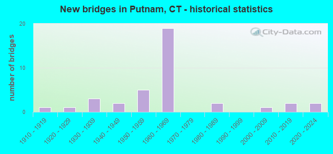
- New bridges - historical statistics
- 11910-1919
- 11920-1929
- 31930-1939
- 21940-1949
- 51950-1959
- 191960-1969
- 21980-1989
- 12000-2009
- 22010-2019
- 22020-2022

- Reconstructed bridges - Historical Statistics
- 11960-1969
- 01970-1979
- 91980-1989
- 01990-1999
- 02000-2009
- 12010-2019


- Bridge Condition - Deck
- 20.0%Very good
- 15.0%Good
- 45.0%Satisfactory
- 20.0%Fair

- Bridge Condition - Superstructure
- 13.0%Very good
- 21.7%Good
- 21.7%Satisfactory
- 34.8%Fair
- 4.3%Poor
- 4.3%Serious

- Bridge Condition - Substructure
- 8.7%Very good
- 39.1%Good
- 34.8%Satisfactory
- 13.0%Fair
- 4.3%Poor

- Bridge Condition - Channel
- 11.1%Very good
- 38.9%Good
- 16.7%Satisfactory
- 33.3%Fair

- Bridge Condition - Culverts
- 25.0%Good
- 50.0%Satisfactory
- 25.0%Serious
Find on map >> Show street view
Structure Number: 306, Location: 0.2 MI E OF I- 395 (Lat: 41.766706, Lng: -71.869442), Route carried "on" structure: City street , Year Built: 1958, Year Reconstructed: 1988, Status: Open, Structure Length: 5.30m (17.39ft), Average Daily Traffic: 328 (year 2020), Truck Traffic: 7%, Average Future Daily Traffic: 487 (year 2040), Design Load: HS 20, Features Intersected: SR 695, Facility Carried by Structure: SQUAW ROCK ROAD
Minimum Vertical Clearance: 30+ m (98+ ft), Kilometerpoint: 1.481, Lanes on structure: 2, Lanes under structure: 4, Owner: State Highway Agency, Approaching Roadway Width: 12.2m (40.0ft), Skew: 4 degrees, Material/Design: Steel, Design/Construction: Stringer/Multi-beam, Number Of Spans In Main Unit: 2, Length of Maximum Span: 28.0m (91.9ft), Curb-To-Curb Width: 12.7m (41.7ft), Out-to-Out Width: 13.9m (45.6ft)
Condition: Deck: Good, Superstructure: Satisfactory, Substructure: Good, Operating Rating: 85.3 metric tons, Method Used To Determine Operating Rating: Load Factor (LF), Inventory Rating: 51.2 metric tons, Method Used To Determine Inventory Rating: Load Factor (LF), Structural Evaluation: Equal to present minimum criteria, Deck Geometry: Superior to present desirable criteria, Underclear: Somewhat better than minimum adequacy, Approach Roadway Alignment: Better than present minimum criteria, Designated Inspection Frequency: Every 24 months, Inspection Date: June 2020, Deck Structure Type: Concrete Cast-file-Place, Wearing Surface/Protective System: Wearing Surface: Bituminous, Membrane: Preformed Fabric, Deck Protection: Epoxy Coated Reinforcing
Find on map >> Show street view
Structure Number: 992, Location: 50 FT W OF KENNEDY DRIVE (Lat: 41.915111, Lng: -71.910939), Route carried "on" structure: US 44, Year Built: 1925, Year Reconstructed: 2015, Status: Open, Structure Length: 2.13m (6.99ft), Average Daily Traffic: 13,100 (year 2018), Truck Traffic: 6%, Average Future Daily Traffic: 19,465 (year 2038), Design Load: H 15, Features Intersected: QUINEBAUG RIVER
Minimum Vertical Clearance: 30+ m (98+ ft), Kilometerpoint: 160.516, Lanes on structure: 2, Base Highway Network: Yes, Owner: State Highway Agency, Approaching Roadway Width: 9.3m (30.5ft), Material/Design: Concrete, Design/Construction: Arch - Deck, Number Of Spans In Main Unit: 1, Length of Maximum Span: 21.3m (69.9ft), Curb or Sidewalk Widths: Left: 1.8m (5.9ft), Right: 1.8m (5.9ft), Curb-To-Curb Width: 9.3m (30.5ft), Out-to-Out Width: 13.9m (45.6ft)
Condition: Superstructure: Satisfactory, Substructure: Fair, Channel: Good, Operating Rating: 97.2 metric tons, Method Used To Determine Operating Rating: Load and Resistance Factor Rating (LRFR) rating reported by rating factor(RF) method using HL-93 loadings, Inventory Rating: 97.2 metric tons, Method Used To Determine Inventory Rating: Load and Resistance Factor Rating (LRFR) rating reported by rating factor(RF) method using HL-93 loadings, Structural Evaluation: Somewhat better than minimum adequacy, Deck Geometry: High priority of corrective action, Waterway Adequacy: Better than present minimum criteria, Approach Roadway Alignment: Equal to present desirable criteria, Designated Inspection Frequency: Every 24 months, Inspection Date: December 2021, Wearing Surface/Protective System: Wearing Surface: Bituminous, Membrane: Other
Find on map >> Show street view
Structure Number: 994, Location: 2 MI EAST OF ROUTE 21 (Lat: 41.918769, Lng: -71.829833), Route carried "on" structure: US 44, Year Built: 1931, Status: Open, Structure Length: 1.07m (3.51ft), Average Daily Traffic: 4,700 (year 2016), Truck Traffic: 4%, Average Future Daily Traffic: 6,984 (year 2036), Features Intersected: FIVE MILE RIVER
Minimum Vertical Clearance: 30+ m (98+ ft), Kilometerpoint: 167.935, Lanes on structure: 2, Base Highway Network: Yes, Owner: State Highway Agency, Approaching Roadway Width: 9.1m (29.9ft), Material/Design: Concrete, Design/Construction: Arch - Deck, Number Of Spans In Main Unit: 1, Length of Maximum Span: 10.7m (35.1ft), Curb-To-Curb Width: 9.1m (29.9ft), Out-to-Out Width: 9.9m (32.5ft)
Condition: Superstructure: Fair, Substructure: Satisfactory, Channel: Good, Operating Rating: 42.6 metric tons, Method Used To Determine Operating Rating: Field evaluation and documented engineering judgment, Inventory Rating: 32.7 metric tons, Method Used To Determine Inventory Rating: Field evaluation and documented engineering judgment, Structural Evaluation: Somewhat better than minimum adequacy, Deck Geometry: Meets minimum limits, Waterway Adequacy: Better than present minimum criteria, Approach Roadway Alignment: Equal to present desirable criteria, Designated Inspection Frequency: Every 24 months, Inspection Date: June 2021
Find on map >> Show street view
Structure Number: 1424, Location: .3 MI W OF US ROUTE 44 (Lat: 41.922842, Lng: -71.907311), Route carried "on" structure: State highway 171, Year Built: 1952, Year Reconstructed: 1988, Status: Open, Structure Length: 3.57m (11.71ft), Average Daily Traffic: 9,700 (year 2019), Truck Traffic: 3%, Average Future Daily Traffic: 14,413 (year 2039), Design Load: HS 20, Features Intersected: QUINEBAUG RIVER
Minimum Vertical Clearance: 30+ m (98+ ft), Kilometerpoint: 32.831, Lanes on structure: 2, Owner: State Highway Agency, Approaching Roadway Width: 12.2m (40.0ft), Material/Design: Steel, Design/Construction: Stringer/Multi-beam, Number Of Spans In Main Unit: 1, Length of Maximum Span: 34.1m (111.9ft), Curb or Sidewalk Widths: Left: 1.8m (5.9ft), Right: 1.8m (5.9ft), Curb-To-Curb Width: 12.2m (40.0ft), Out-to-Out Width: 16.5m (54.1ft)
Condition: Deck: Good, Superstructure: Fair, Substructure: Satisfactory, Channel: Satisfactory, Operating Rating: 97.1 metric tons, Method Used To Determine Operating Rating: Load Factor (LF), Inventory Rating: 58.3 metric tons, Method Used To Determine Inventory Rating: Load Factor (LF), Structural Evaluation: Somewhat better than minimum adequacy, Deck Geometry: Somewhat better than minimum adequacy, Waterway Adequacy: Equal to present desirable criteria, Approach Roadway Alignment: Equal to present minimum criteria, Designated Inspection Frequency: Every 24 months, Inspection Date: November 2021, Deck Structure Type: Concrete Cast-file-Place, Wearing Surface/Protective System: Wearing Surface: Bituminous, Membrane: Preformed Fabric, Deck Protection: Epoxy Coated Reinforcing
Find on map >> Show street view
Structure Number: 1425, Location: 600' WEST OF JCT ROUTE 12 (Lat: 41.921569, Lng: -71.904097), Route carried "on" structure: State highway 171, Year Built: 1957, Year Reconstructed: 1985, Status: Open, Structure Length: 1.74m (5.71ft), Average Daily Traffic: 9,700 (year 2016), Truck Traffic: 5%, Average Future Daily Traffic: 14,413 (year 2036), Design Load: HS 20, Features Intersected: PROV & WORC RAILROAD
Minimum Vertical Clearance: 30+ m (98+ ft), Kilometerpoint: 33.136, Lanes on structure: 2, Owner: State Highway Agency, Approaching Roadway Width: 12.2m (40.0ft), Material/Design: Steel, Design/Construction: Stringer/Multi-beam, Number Of Spans In Main Unit: 1, Length of Maximum Span: 15.5m (50.9ft), Curb or Sidewalk Widths: Left: 1.8m (5.9ft), Right: 1.8m (5.9ft), Curb-To-Curb Width: 12.2m (40.0ft), Out-to-Out Width: 16.6m (54.5ft)
Condition: Deck: Fair, Superstructure: Good, Substructure: Good, Operating Rating: 72.9 metric tons, Method Used To Determine Operating Rating: Load Factor (LF), Inventory Rating: 43.8 metric tons, Method Used To Determine Inventory Rating: Load Factor (LF), Structural Evaluation: Better than present minimum criteria, Deck Geometry: Somewhat better than minimum adequacy, Underclear: High priority of corrective action, Approach Roadway Alignment: Equal to present desirable criteria, Designated Inspection Frequency: Every 24 months, Inspection Date: March 2021, Deck Structure Type: Concrete Cast-file-Place, Wearing Surface/Protective System: Wearing Surface: Bituminous, Membrane: Preformed Fabric
Find on map >> Show street view
Structure Number: 3056, Location: 1.3 MI S OF US ROUTE 44 (Lat: 41.905806, Lng: -71.894050), Route carried "on" structure: State highway 12, Year Built: 1965, Status: Open, Structure Length: 8.02m (26.31ft), Average Daily Traffic: 1,900 (year 2016), Truck Traffic: 6%, Average Future Daily Traffic: 2,823 (year 2036), Design Load: H 20, Features Intersected: INTERSTATE-395
Minimum Vertical Clearance: 30+ m (98+ ft), Kilometerpoint: 71.471, Lanes on structure: 2, Lanes under structure: 5, Owner: State Highway Agency, Approaching Roadway Width: 12.2m (40.0ft), Skew: 9 degrees, Material/Design: Steel, Design/Construction: Stringer/Multi-beam, Number Of Spans In Main Unit: 4, Length of Maximum Span: 24.1m (79.1ft), Curb or Sidewalk Widths: Left: 1.7m (5.6ft), Right: 1.7m (5.6ft), Curb-To-Curb Width: 12.2m (40.0ft), Out-to-Out Width: 16.4m (53.8ft)
Condition: Deck: Satisfactory, Superstructure: Fair, Substructure: Satisfactory, Operating Rating: 87.1 metric tons, Method Used To Determine Operating Rating: Load Factor (LF), Inventory Rating: 51.7 metric tons, Method Used To Determine Inventory Rating: Load Factor (LF), Structural Evaluation: Somewhat better than minimum adequacy, Deck Geometry: Better than present minimum criteria, Underclear: Somewhat better than minimum adequacy, Approach Roadway Alignment: Equal to present desirable criteria, Designated Inspection Frequency: Every 24 months, Inspection Date: July 2021, Deck Structure Type: Concrete Cast-file-Place, Wearing Surface/Protective System: Wearing Surface: Bituminous, Membrane: Preformed Fabric
Find on map >> Show street view
Structure Number: 3059, Location: .3 MI S OF ROUTE US 44 (Lat: 41.920636, Lng: -71.886678), Route carried "on" structure: City street , Year Built: 1965, Status: Open, Structure Length: 6.54m (21.46ft), Average Daily Traffic: 2,650 (year 2021), Truck Traffic: 2%, Average Future Daily Traffic: 3,938 (year 2041), Design Load: HS 20, Features Intersected: INTERSTATE-395, Facility Carried by Structure: WALNUT STREET
Minimum Vertical Clearance: 30+ m (98+ ft), Kilometerpoint: 75.494, Lanes on structure: 2, Lanes under structure: 4, Owner: State Highway Agency, Approaching Roadway Width: 10.4m (34.1ft), Material/Design: Steel continuous, Design/Construction: Stringer/Multi-beam, Number Of Spans In Main Unit: 2, Length of Maximum Span: 32.0m (105.0ft), Curb or Sidewalk Widths: Left: 0.5m (1.6ft), Right: 0.5m (1.6ft), Curb-To-Curb Width: 10.4m (34.1ft), Out-to-Out Width: 12.0m (39.4ft)
Condition: Deck: Fair, Superstructure: Fair, Substructure: Good, Operating Rating: 42.8 metric tons, Method Used To Determine Operating Rating: Load and Resistance Factor Rating (LRFR) rating reported by rating factor(RF) method using HL-93 loadings, Inventory Rating: 33.0 metric tons, Method Used To Determine Inventory Rating: Load and Resistance Factor Rating (LRFR) rating reported by rating factor(RF) method using HL-93 loadings, Structural Evaluation: Somewhat better than minimum adequacy, Deck Geometry: Somewhat better than minimum adequacy, Underclear: Equal to present minimum criteria, Approach Roadway Alignment: Equal to present desirable criteria, Designated Inspection Frequency: Every 24 months, Inspection Date: August 2021, Deck Structure Type: Concrete Cast-file-Place, Wearing Surface/Protective System: Wearing Surface: Bituminous, Membrane: Preformed Fabric
Find on map >> Show street view
Structure Number: 306, Location: 2.7 MI SOUTH OF ROUTE 200 (Lat: 41.924281, Lng: -71.885142), Route carried "on" structure: Interstate 395, Year Built: 1965, Year Reconstructed: 1993, Status: Open, Structure Length: 5.09m (16.70ft), Average Daily Traffic: 12,200 (year 2017), Truck Traffic: 14%, Average Future Daily Traffic: 18,128 (year 2037), Design Load: HS 20, Features Intersected: US ROUTE 44 (SCHOOL ST)
Minimum Vertical Clearance: 30+ m (98+ ft), Kilometerpoint: 75.897, Lanes on structure: 2, Lanes under structure: 2, Base Highway Network: Yes, Owner: State Highway Agency, Approaching Roadway Width: 14.6m (47.9ft), Skew: 2 degrees, Material/Design: Steel, Design/Construction: Stringer/Multi-beam, Number Of Spans In Main Unit: 3, Length of Maximum Span: 23.2m (76.1ft), Curb-To-Curb Width: 15.2m (49.9ft), Out-to-Out Width: 16.3m (53.5ft)
Condition: Deck: Satisfactory, Superstructure: Fair, Substructure: Satisfactory, Operating Rating: 52.8 metric tons, Method Used To Determine Operating Rating: Load and Resistance Factor Rating (LRFR) rating reported by rating factor(RF) method using HL-93 loadings, Inventory Rating: 40.8 metric tons, Method Used To Determine Inventory Rating: Load and Resistance Factor Rating (LRFR) rating reported by rating factor(RF) method using HL-93 loadings, Structural Evaluation: Somewhat better than minimum adequacy, Deck Geometry: Superior to present desirable criteria, Underclear: High priority of corrective action, Approach Roadway Alignment: Equal to present desirable criteria, Designated Inspection Frequency: Every 24 months, Inspection Date: March 2021, Deck Structure Type: Concrete Cast-file-Place, Wearing Surface/Protective System: Wearing Surface: Bituminous, Membrane: Preformed Fabric
Find on map >> Show street view
Structure Number: 3061, Location: AT THE JCT OF US ROUTE 44 (Lat: 41.924344, Lng: -71.884261), Route carried "on" structure: Interstate 395, Year Built: 1965, Year Reconstructed: 1993, Status: Open, Structure Length: 4.66m (15.29ft), Average Daily Traffic: 9,200 (year 2017), Truck Traffic: 14%, Average Future Daily Traffic: 13,670 (year 2037), Design Load: HS 20, Features Intersected: US ROUTE 44 (SCHOOL ST.)
Minimum Vertical Clearance: 30+ m (98+ ft), Kilometerpoint: 75.929, Lanes on structure: 2, Lanes under structure: 4, Base Highway Network: Yes, Owner: State Highway Agency, Approaching Roadway Width: 11.6m (38.1ft), Skew: 3 degrees, Material/Design: Steel, Design/Construction: Stringer/Multi-beam, Number Of Spans In Main Unit: 3, Length of Maximum Span: 23.2m (76.1ft), Curb-To-Curb Width: 12.1m (39.7ft), Out-to-Out Width: 13.3m (43.6ft)
Condition: Deck: Satisfactory, Superstructure: Fair, Substructure: Good, Operating Rating: 56.7 metric tons, Method Used To Determine Operating Rating: Load and Resistance Factor Rating (LRFR) rating reported by rating factor(RF) method using HL-93 loadings, Inventory Rating: 43.7 metric tons, Method Used To Determine Inventory Rating: Load and Resistance Factor Rating (LRFR) rating reported by rating factor(RF) method using HL-93 loadings, Structural Evaluation: Somewhat better than minimum adequacy, Deck Geometry: Equal to present minimum criteria, Underclear: High priority of corrective action, Approach Roadway Alignment: Better than present minimum criteria, Designated Inspection Frequency: Every 24 months, Inspection Date: March 2021, Deck Structure Type: Concrete Cast-file-Place, Wearing Surface/Protective System: Wearing Surface: Bituminous, Membrane: Preformed Fabric
Find on map >> Show street view
Structure Number: 3065, Location: .11 MI SO THOMPSON TL. (Lat: 41.930950, Lng: -71.881192), Route carried "on" structure: City street , Year Built: 1965, Status: Open, Structure Length: 2.90m (9.51ft), Average Daily Traffic: 380 (year 2015), Truck Traffic: 7%, Average Future Daily Traffic: 565 (year 2035), Design Load: HS 20, Features Intersected: INTERSTATE-395 SB, Facility Carried by Structure: SAYLE AVENUE
Minimum Vertical Clearance: 30+ m (98+ ft), Kilometerpoint: 76.734, Lanes on structure: 2, Lanes under structure: 2, Owner: State Highway Agency, Approaching Roadway Width: 9.1m (29.9ft), Material/Design: Steel, Design/Construction: Stringer/Multi-beam, Number Of Spans In Main Unit: 1, Length of Maximum Span: 26.8m (87.9ft), Curb or Sidewalk Widths: Left: 0.5m (1.6ft), Right: 0.5m (1.6ft), Curb-To-Curb Width: 9.1m (29.9ft), Out-to-Out Width: 11.0m (36.1ft)
Condition: Deck: Good, Superstructure: Satisfactory, Substructure: Good, Inventory Rating: 64.9 metric tons, Method Used To Determine Inventory Rating: Load Factor (LF), Structural Evaluation: Equal to present minimum criteria, Deck Geometry: Equal to present minimum criteria, Underclear: Somewhat better than minimum adequacy, Approach Roadway Alignment: Equal to present desirable criteria, Designated Inspection Frequency: Every 48 months, Inspection Date: September 2019, Deck Structure Type: Concrete Cast-file-Place, Wearing Surface/Protective System: Wearing Surface: Bituminous
Find on map >> Show street view
Structure Number: 3066, Location: .11 SOUTH OF THOMPSON TL. (Lat: 41.930572, Lng: -71.880175), Route carried "on" structure: City street , Year Built: 1965, Status: Open, Structure Length: 2.90m (9.51ft), Average Daily Traffic: 400 (year 2021), Truck Traffic: 7%, Average Future Daily Traffic: 594 (year 2041), Design Load: HS 20, Features Intersected: INTERSTATE-395 NB, Facility Carried by Structure: SAYLE AVENUE
Minimum Vertical Clearance: 30+ m (98+ ft), Kilometerpoint: 76.717, Lanes on structure: 2, Lanes under structure: 2, Owner: State Highway Agency, Approaching Roadway Width: 9.1m (29.9ft), Material/Design: Steel, Design/Construction: Stringer/Multi-beam, Number Of Spans In Main Unit: 1, Length of Maximum Span: 26.8m (87.9ft), Curb or Sidewalk Widths: Left: 0.5m (1.6ft), Right: 0.5m (1.6ft), Curb-To-Curb Width: 9.1m (29.9ft), Out-to-Out Width: 11.0m (36.1ft)
Condition: Deck: Satisfactory, Superstructure: Good, Substructure: Good, Operating Rating: 80.5 metric tons, Method Used To Determine Operating Rating: Load Factor (LF), Inventory Rating: 48.3 metric tons, Method Used To Determine Inventory Rating: Load Factor (LF), Structural Evaluation: Better than present minimum criteria, Deck Geometry: Equal to present minimum criteria, Underclear: Meets minimum limits, Approach Roadway Alignment: Equal to present desirable criteria, Designated Inspection Frequency: Every 24 months, Inspection Date: September 2021, Deck Structure Type: Concrete Cast-file-Place, Wearing Surface/Protective System: Wearing Surface: Bituminous, Membrane: Built-up
Find on map >> Show street view
Structure Number: 3255, Location: 0.2 MI WEST OF ROUTE 12 (Lat: 41.915036, Lng: -71.911647), Route carried "on" structure: US 44, Year Built: 1935, Year Reconstructed: 1987, Status: Open, Structure Length: 0.64m (2.10ft), Average Daily Traffic: 9,800 (year 2016), Truck Traffic: 4%, Average Future Daily Traffic: 14,562 (year 2036), Features Intersected: CANAL
Minimum Vertical Clearance: 30+ m (98+ ft), Kilometerpoint: 160.500, Lanes on structure: 2, Base Highway Network: Yes, Owner: State Highway Agency, Approaching Roadway Width: 9.4m (30.8ft), Material/Design: Concrete, Design/Construction: Slab, Number Of Spans In Main Unit: 1, Length of Maximum Span: 4.0m (13.1ft), Curb or Sidewalk Widths: Left: 2.0m (6.6ft), Right: 1.5m (4.9ft), Curb-To-Curb Width: 9.4m (30.8ft), Out-to-Out Width: 12.8m (42.0ft)
Condition: Superstructure: Good, Substructure: Good, Channel: Good, Operating Rating: 52.6 metric tons, Method Used To Determine Operating Rating: Field evaluation and documented engineering judgment, Inventory Rating: 30.8 metric tons, Method Used To Determine Inventory Rating: Field evaluation and documented engineering judgment, Structural Evaluation: Better than present minimum criteria, Deck Geometry: High priority of corrective action, Waterway Adequacy: Equal to present desirable criteria, Approach Roadway Alignment: Equal to present desirable criteria, Designated Inspection Frequency: Every 24 months, Underwater Inspection Frequency: Every 24 months, Inspection Date: November 2020, Underwater Inspection Date: November 2020, Deck Structure Type: Concrete Cast-file-Place
Find on map >> Show street view
Structure Number: 3472, Location: INTERSTATE 395 AT EXIT 45 (Lat: 41.899458, Lng: -71.899022), Route carried "on" structure: City street , Year Built: 1967, Year Reconstructed: 1993, Status: Open, Structure Length: 8.05m (26.41ft), Average Daily Traffic: 8,100 (year 2016), Truck Traffic: 3%, Average Future Daily Traffic: 12,036 (year 2036), Design Load: HS 20, Features Intersected: I-395 & I-395 RAMP 061, Facility Carried by Structure: KENNEDY DRIVE
Minimum Vertical Clearance: 30+ m (98+ ft), Kilometerpoint: 3.243, Lanes on structure: 2, Lanes under structure: 5, Owner: State Highway Agency, Approaching Roadway Width: 12.2m (40.0ft), Skew: 3 degrees, Material/Design: Steel continuous, Design/Construction: Stringer/Multi-beam, Number Of Spans In Main Unit: 2, Length of Maximum Span: 40.2m (131.9ft), Curb or Sidewalk Widths: Left: 0.5m (1.6ft), Right: 0.5m (1.6ft), Curb-To-Curb Width: 12.2m (40.0ft), Out-to-Out Width: 13.9m (45.6ft)
Condition: Deck: Satisfactory, Superstructure: Fair, Substructure: Satisfactory, Operating Rating: 74.7 metric tons, Method Used To Determine Operating Rating: Load Factor (LF), Inventory Rating: 44.7 metric tons, Method Used To Determine Inventory Rating: Load Factor (LF), Structural Evaluation: Somewhat better than minimum adequacy, Deck Geometry: Somewhat better than minimum adequacy, Underclear: High priority of corrective action, Approach Roadway Alignment: Equal to present desirable criteria, Designated Inspection Frequency: Every 24 months, Inspection Date: August 2021, Deck Structure Type: Concrete Cast-file-Place, Wearing Surface/Protective System: Wearing Surface: Bituminous, Membrane: Built-up
Find on map >> Show street view
Structure Number: 3968, Location: 1/8 MILE EAST OF SABIN ST (Lat: 41.918203, Lng: -71.920408), Route carried "on" structure: City street , Year Built: 2020, Status: Open, Structure Length: 1.24m (4.07ft), Average Daily Traffic: 772 (year 2020), Truck Traffic: 3%, Average Future Daily Traffic: 1,147 (year 2040), Design Load: HL 93, Features Intersected: LITTLE RIVER, Facility Carried by Structure: RECREATION PARK ST
Minimum Vertical Clearance: 30+ m (98+ ft), Kilometerpoint: 0.145, Lanes on structure: 2, Owner: Town or Township Highway Agency, Approaching Roadway Width: 8.4m (27.6ft), Material/Design: Prestressed concrete, Design/Construction: Tee Beam, Number Of Spans In Main Unit: 1, Length of Maximum Span: 11.2m (36.7ft), Curb-To-Curb Width: 8.5m (27.9ft), Out-to-Out Width: 9.4m (30.8ft)
Condition: Deck: Very good, Superstructure: Very good, Substructure: Very good, Channel: Good, Operating Rating: 76.1 metric tons, Method Used To Determine Operating Rating: Load and Resistance Factor Rating (LRFR) rating reported by rating factor(RF) method using HL-93 loadings, Inventory Rating: 58.6 metric tons, Method Used To Determine Inventory Rating: Load and Resistance Factor Rating (LRFR) rating reported by rating factor(RF) method using HL-93 loadings, Structural Evaluation: Equal to present desirable criteria, Deck Geometry: Somewhat better than minimum adequacy, Waterway Adequacy: Equal to present minimum criteria, Approach Roadway Alignment: Equal to present minimum criteria, Designated Inspection Frequency: Every 24 months, Inspection Date: September 2020, Total Project Cost: $3,400,000, Deck Structure Type: Other, Wearing Surface/Protective System: Wearing Surface: Bituminous, Membrane: Preformed Fabric
Find on map >> Show street view
Structure Number: 3969, Location: 0.5 MI SOUTH OF ROUTE 171 (Lat: 41.918522, Lng: -71.910350), Route carried "on" structure: City street , Year Built: 1958, Status: Open, Structure Length: 8.08m (26.51ft), Average Daily Traffic: 8,150 (year 2020), Truck Traffic: 3%, Average Future Daily Traffic: 12,110 (year 2040), Design Load: H 20, Features Intersected: QUINEBAUG RIVER, Facility Carried by Structure: BRIDGE STREET
Minimum Vertical Clearance: 30+ m (98+ ft), Kilometerpoint: 0.370, Lanes on structure: 3, Owner: Town or Township Highway Agency, Approaching Roadway Width: 9.4m (30.8ft), Skew: 2 degrees, Material/Design: Steel continuous, Design/Construction: Stringer/Multi-beam, Number Of Spans In Main Unit: 3, Length of Maximum Span: 30.5m (100.1ft), Curb or Sidewalk Widths: Left: 0.5m (1.6ft), Right: 1.5m (4.9ft), Curb-To-Curb Width: 9.6m (31.5ft), Out-to-Out Width: 12.3m (40.4ft)
Condition: Deck: Fair, Superstructure: Serious, Substructure: Satisfactory, Channel: Good, Operating Rating: 77.1 metric tons, Method Used To Determine Operating Rating: Load Factor (LF), Inventory Rating: 46.3 metric tons, Method Used To Determine Inventory Rating: Load Factor (LF), Structural Evaluation: High priority of corrective action, Deck Geometry: High priority of replacement, Waterway Adequacy: Equal to present minimum criteria, Approach Roadway Alignment: Equal to present minimum criteria, Designated Inspection Frequency: Every 24 months, Underwater Inspection Frequency: Every 48 months, Inspection Date: September 2020, Underwater Inspection Date: August 2020, Deck Structure Type: Concrete Cast-file-Place, Wearing Surface/Protective System: Wearing Surface: Bituminous, Membrane: Preformed Fabric
Find on map >> Show street view
Structure Number: 476, Location: 1050'SOUTH OF ROUTE 171 (Lat: 41.927778, Lng: -71.930164), Route carried "on" structure: City street , Year Built: 2020, Status: Open, Structure Length: 2.35m (7.71ft), Average Daily Traffic: 1,370 (year 2016), Truck Traffic: 2%, Average Future Daily Traffic: 2,036 (year 2036), Design Load: H 20, Features Intersected: LITTLE RIVER, Facility Carried by Structure: WOODSTOCK AVE #1
Minimum Vertical Clearance: 30+ m (98+ ft), Kilometerpoint: 0.097, Lanes on structure: 2, Owner: Town or Township Highway Agency, Approaching Roadway Width: 9.8m (32.2ft), Material/Design: Concrete, Design/Construction: Tee Beam, Number Of Spans In Main Unit: 1, Length of Maximum Span: 21.3m (69.9ft), Curb-To-Curb Width: 9.8m (32.2ft), Out-to-Out Width: 11.0m (36.1ft)
Condition: Deck: Very good, Superstructure: Very good, Substructure: Very good, Channel: Good, Operating Rating: 60.8 metric tons, Method Used To Determine Operating Rating: Load Factor (LF), Inventory Rating: 36.3 metric tons, Method Used To Determine Inventory Rating: Load Factor (LF), Structural Evaluation: Equal to present desirable criteria, Deck Geometry: Somewhat better than minimum adequacy, Waterway Adequacy: Somewhat better than minimum adequacy, Approach Roadway Alignment: Better than present minimum criteria, Designated Inspection Frequency: Every 24 months, Inspection Date: September 2020, Total Project Cost: $1,350,000 ( Estimate for 2016), Deck Structure Type: Concrete Cast-file-Place, Wearing Surface/Protective System: Wearing Surface: Bituminous, Membrane: Preformed Fabric
Find on map >> Show street view
Structure Number: 4761, Location: .5 MI WEST OF E PUTNAM RD (Lat: 41.897586, Lng: -71.831633), Route carried "on" structure: City street , Year Built: 2015, Status: Open, Structure Length: 1.10m (3.61ft), Average Daily Traffic: 333 (year 2020), Truck Traffic: 7%, Average Future Daily Traffic: 495 (year 2040), Design Load: HL 93, Features Intersected: FIVE MILE RIVER, Facility Carried by Structure: CHASE ROAD
Minimum Vertical Clearance: 30+ m (98+ ft), Kilometerpoint: 2.060, Lanes on structure: 2, Owner: Town or Township Highway Agency, Approaching Roadway Width: 7.4m (24.3ft), Skew: 1 degrees, Material/Design: Concrete, Design/Construction: Culvert, Number Of Spans In Main Unit: 2, Length of Maximum Span: 4.9m (16.1ft), Curb-To-Curb Width: 7.4m (24.3ft), Out-to-Out Width: 8.5m (27.9ft)
Condition: Channel: Satisfactory, Culverts: Good, Operating Rating: 48.0 metric tons, Method Used To Determine Operating Rating: Load and Resistance Factor Rating (LRFR) rating reported by rating factor(RF) method using HL-93 loadings, Inventory Rating: 36.9 metric tons, Method Used To Determine Inventory Rating: Load and Resistance Factor Rating (LRFR) rating reported by rating factor(RF) method using HL-93 loadings, Structural Evaluation: Better than present minimum criteria, Deck Geometry: Somewhat better than minimum adequacy, Waterway Adequacy: Equal to present desirable criteria, Approach Roadway Alignment: High priority of corrective action, Designated Inspection Frequency: Every 24 months, Inspection Date: September 2020, Deck Structure Type: Concrete Cast-file-Place, Wearing Surface/Protective System: Wearing Surface: Bituminous, Membrane: Built-up
Find on map >> Show street view
Structure Number: 4762, Location: .2 MI E OF TUCKER HILL RD (Lat: 41.914161, Lng: -71.832428), Route carried "on" structure: City street , Year Built: 1930, Year Reconstructed: 1965, Status: Open, Structure Length: 0.94m (3.08ft), Average Daily Traffic: 857 (year 2020), Truck Traffic: 6%, Average Future Daily Traffic: 1,273 (year 2040), Features Intersected: FIVE MILE RIVER, Facility Carried by Structure: FIVE MILE RIVER RD
Minimum Vertical Clearance: 30+ m (98+ ft), Kilometerpoint: 3.444, Lanes on structure: 2, Owner: Town or Township Highway Agency, Approaching Roadway Width: 6.1m (20.0ft), Skew: 1 degrees, Material/Design: Concrete, Design/Construction: Slab, Number Of Spans In Main Unit: 1, Length of Maximum Span: 7.9m (25.9ft), Curb-To-Curb Width: 7.6m (24.9ft), Out-to-Out Width: 8.0m (26.2ft)
Condition: Deck: Fair, Superstructure: Fair, Substructure: Poor, Channel: Fair, Operating Rating: 42.6 metric tons, Method Used To Determine Operating Rating: Field evaluation and documented engineering judgment, Inventory Rating: 32.7 metric tons, Method Used To Determine Inventory Rating: Field evaluation and documented engineering judgment, Structural Evaluation: Meets minimum limits, Deck Geometry: Meets minimum limits, Waterway Adequacy: Better than present minimum criteria, Approach Roadway Alignment: Equal to present minimum criteria, Designated Inspection Frequency: Every 24 months, Underwater Inspection Frequency: Every 24 months, Inspection Date: September 2020, Underwater Inspection Date: September 2020, Deck Structure Type: Concrete Cast-file-Place, Wearing Surface/Protective System: Wearing Surface: Bituminous
Find on map >> Show street view
Structure Number: 4763, Location: 3000FT FR JCT ROUTE 44 (Lat: 41.927433, Lng: -71.832556), Route carried "on" structure: City street , Year Built: 2000, Status: Open, Structure Length: 1.04m (3.41ft), Average Daily Traffic: 646 (year 2018), Truck Traffic: 7%, Average Future Daily Traffic: 960 (year 2038), Design Load: HS 20, Features Intersected: FIVE MILE RIVER, Facility Carried by Structure: MUNYAN ROAD
Minimum Vertical Clearance: 30+ m (98+ ft), Kilometerpoint: 3.364, Lanes on structure: 2, Owner: Town or Township Highway Agency, Approaching Roadway Width: 8.5m (27.9ft), Material/Design: Prestressed concrete, Design/Construction: Slab, Number Of Spans In Main Unit: 1, Length of Maximum Span: 9.0m (29.5ft), Curb-To-Curb Width: 8.4m (27.6ft), Out-to-Out Width: 9.5m (31.2ft)
Condition: Deck: Very good, Superstructure: Very good, Substructure: Good, Channel: Very good, Operating Rating: 85.1 metric tons, Method Used To Determine Operating Rating: Load Factor (LF), Inventory Rating: 51.0 metric tons, Method Used To Determine Inventory Rating: Load Factor (LF), Structural Evaluation: Better than present minimum criteria, Deck Geometry: Somewhat better than minimum adequacy, Waterway Adequacy: Somewhat better than minimum adequacy, Approach Roadway Alignment: Equal to present desirable criteria, Designated Inspection Frequency: Every 48 months, Inspection Date: September 2018, Deck Structure Type: Other, Wearing Surface/Protective System: Wearing Surface: Bituminous, Membrane: Preformed Fabric, Deck Protection: Epoxy Coated Reinforcing
Find on map >> Show street view
Structure Number: 4764, Location: 0.7 MI SOUTH OF ROUTE 44 (Lat: 41.909039, Lng: -71.819186), Route carried "on" structure: City street , Year Built: 1940, Year Reconstructed: 1991, Status: Open, Structure Length: 0.73m (2.40ft), Average Daily Traffic: 1,344 (year 2018), Truck Traffic: 7%, Average Future Daily Traffic: 1,997 (year 2038), Design Load: HS 20, Features Intersected: CADY BROOK, Facility Carried by Structure: EAST PUTNAM ROAD
Minimum Vertical Clearance: 30+ m (98+ ft), Kilometerpoint: 2.285, Lanes on structure: 2, Owner: Town or Township Highway Agency, Approaching Roadway Width: 6.1m (20.0ft), Material/Design: Steel, Design/Construction: Stringer/Multi-beam, Number Of Spans In Main Unit: 1, Length of Maximum Span: 5.8m (19.0ft), Curb-To-Curb Width: 7.3m (24.0ft), Out-to-Out Width: 7.3m (24.0ft)
Condition: Deck: Satisfactory, Superstructure: Poor, Substructure: Fair, Channel: Fair, Operating Rating: 57.4 metric tons, Method Used To Determine Operating Rating: Load Factor (LF), Inventory Rating: 34.5 metric tons, Method Used To Determine Inventory Rating: Load Factor (LF), Structural Evaluation: Meets minimum limits, Deck Geometry: Meets minimum limits, Waterway Adequacy: Somewhat better than minimum adequacy, Approach Roadway Alignment: Better than present minimum criteria, Designated Inspection Frequency: Every 24 months, Inspection Date: September 2020, Deck Structure Type: Corrugated Steel, Wearing Surface/Protective System: Wearing Surface: Bituminous, Membrane: Preformed Fabric
Find on map >> Show street view
Structure Number: 4765, Location: 320FT EAST OF CADY ROAD (Lat: 41.905378, Lng: -71.815481), Route carried "on" structure: City street , Year Built: 1940, Year Reconstructed: 1991, Status: Open, Structure Length: 0.73m (2.40ft), Average Daily Traffic: 233 (year 2020), Truck Traffic: 7%, Average Future Daily Traffic: 346 (year 2040), Design Load: HS 20, Features Intersected: CADY BROOK, Facility Carried by Structure: CHASE ROAD
Minimum Vertical Clearance: 30+ m (98+ ft), Kilometerpoint: 3.074, Lanes on structure: 2, Owner: Town or Township Highway Agency, Approaching Roadway Width: 5.8m (19.0ft), Material/Design: Wood or Timber, Design/Construction: Slab, Number Of Spans In Main Unit: 1, Length of Maximum Span: 6.7m (22.0ft), Curb-To-Curb Width: 6.6m (21.7ft), Out-to-Out Width: 7.0m (23.0ft)
Condition: Deck: Satisfactory, Superstructure: Satisfactory, Substructure: Satisfactory, Channel: Fair, Operating Rating: 42.1 metric tons, Method Used To Determine Operating Rating: Load and Resistance Factor Rating (LRFR) rating reported by rating factor(RF) method using HL-93 loadings, Inventory Rating: 32.4 metric tons, Method Used To Determine Inventory Rating: Load and Resistance Factor Rating (LRFR) rating reported by rating factor(RF) method using HL-93 loadings, Structural Evaluation: Equal to present minimum criteria, Deck Geometry: Meets minimum limits, Waterway Adequacy: Somewhat better than minimum adequacy, Approach Roadway Alignment: Better than present minimum criteria, Designated Inspection Frequency: Every 24 months, Inspection Date: September 2020, Deck Structure Type: Wood or Timber, Wearing Surface/Protective System: Wearing Surface: Bituminous, Deck Protection: Other
Find on map >> Show street view
Structure Number: 5544, Location: 0.4 MI WEST OF KENNEDY DR (Lat: 41.912008, Lng: -71.915892), Route carried "on" structure: US 44, Year Built: 1987, Status: Open, Structure Length: 2.03m (6.66ft), Average Daily Traffic: 9,800 (year 2016), Truck Traffic: 4%, Average Future Daily Traffic: 14,562 (year 2036), Design Load: HS 20, Features Intersected: LITTLE RIVER
Minimum Vertical Clearance: 30+ m (98+ ft), Kilometerpoint: 159.969, Lanes on structure: 2, Base Highway Network: Yes, Owner: State Highway Agency, Approaching Roadway Width: 12.2m (40.0ft), Material/Design: Prestressed concrete, Design/Construction: Stringer/Multi-beam, Number Of Spans In Main Unit: 1, Length of Maximum Span: 18.6m (61.0ft), Curb or Sidewalk Widths: Left: 0.0m, Right: 1.6m (5.2ft), Curb-To-Curb Width: 12.3m (40.4ft), Out-to-Out Width: 14.9m (48.9ft)
Condition: Deck: Satisfactory, Superstructure: Good, Substructure: Satisfactory, Channel: Good, Operating Rating: 77.1 metric tons, Method Used To Determine Operating Rating: Load Factor (LF), Inventory Rating: 45.4 metric tons, Method Used To Determine Inventory Rating: Load Factor (LF), Structural Evaluation: Equal to present minimum criteria, Deck Geometry: Somewhat better than minimum adequacy, Waterway Adequacy: Equal to present desirable criteria, Approach Roadway Alignment: Equal to present desirable criteria, Designated Inspection Frequency: Every 24 months, Inspection Date: December 2021, Deck Structure Type: Concrete Cast-file-Place, Wearing Surface/Protective System: Wearing Surface: Bituminous, Membrane: Preformed Fabric, Deck Protection: Epoxy Coated Reinforcing
Find on map >> Show street view
Structure Number: 5613, Location: 0.2 MILE EAST OF ROUTE 44 (Lat: 41.917528, Lng: -71.804100), Route carried "on" structure: City street , Year Built: 1987, Status: Open, Structure Length: 0.77m (2.53ft), Average Daily Traffic: 103 (year 2020), Truck Traffic: 7%, Average Future Daily Traffic: 153 (year 2040), Design Load: HS 20, Features Intersected: MARY BROWN BROOK, Facility Carried by Structure: RHODE ISLND LINE R
Minimum Vertical Clearance: 30+ m (98+ ft), Kilometerpoint: 41.344, Lanes on structure: 2, Owner: Town or Township Highway Agency, Approaching Roadway Width: 5.8m (19.0ft), Skew: 3 degrees, Material/Design: Wood or Timber, Design/Construction: Slab, Number Of Spans In Main Unit: 1, Length of Maximum Span: 6.9m (22.6ft), Curb-To-Curb Width: 6.3m (20.7ft), Out-to-Out Width: 6.6m (21.7ft)
Condition: Deck: Satisfactory, Superstructure: Satisfactory, Substructure: Fair, Channel: Satisfactory, Operating Rating: 52.6 metric tons, Method Used To Determine Operating Rating: Allowable Stress (AS), Inventory Rating: 36.3 metric tons, Method Used To Determine Inventory Rating: Allowable Stress (AS), Structural Evaluation: Somewhat better than minimum adequacy, Deck Geometry: Meets minimum limits, Waterway Adequacy: Somewhat better than minimum adequacy, Approach Roadway Alignment: Equal to present minimum criteria, Designated Inspection Frequency: Every 24 months, Inspection Date: September 2020, Deck Structure Type: Wood or Timber, Wearing Surface/Protective System: Wearing Surface: Bituminous, Deck Protection: Other
Find on map >> Show street view
Structure Number: 5658, Location: .5 MILE SOUTH OF ROUTE 44 (Lat: 41.912953, Lng: -71.817489), Route carried "on" structure: City street , Year Built: 1955, Status: Open, Structure Length: 0.91m (2.99ft), Average Daily Traffic: 658 (year 2020), Truck Traffic: 7%, Average Future Daily Traffic: 978 (year 2040), Features Intersected: MARY BROWN BROOK, Facility Carried by Structure: EAST PUTNAM ROAD
Minimum Vertical Clearance: 30+ m (98+ ft), Kilometerpoint: 0.805, Lanes on structure: 2, Owner: Town or Township Highway Agency, Approaching Roadway Width: 8.8m (28.9ft), Material/Design: Steel, Design/Construction: Culvert, Number Of Spans In Main Unit: 2, Length of Maximum Span: 4.0m (13.1ft), Curb-To-Curb Width: 10.2m (33.5ft), Out-to-Out Width: 11.2m (36.7ft)
Condition: Channel: Fair, Culverts: Serious, Operating Rating: 97.2 metric tons, Method Used To Determine Operating Rating: Load and Resistance Factor Rating (LRFR) rating reported by rating factor(RF) method using HL-93 loadings, Inventory Rating: 78.1 metric tons, Method Used To Determine Inventory Rating: Load and Resistance Factor Rating (LRFR) rating reported by rating factor(RF) method using HL-93 loadings, Structural Evaluation: High priority of corrective action, Deck Geometry: Equal to present minimum criteria, Waterway Adequacy: Better than present minimum criteria, Approach Roadway Alignment: Equal to present desirable criteria, Designated Inspection Frequency: Every 24 months, Other Special Inspection Frequency: Every 6 months, Inspection Date: September 2020, Other Special Inspection Date: September 2021, Total Project Cost: $2,119,000 ( Estimate for 2015)
Find on map >> Show street view
Structure Number: 6652, Location: 42 FEET N OF BRIDGE 03472 (Lat: 41.900017, Lng: -71.896758), Route carried "on" structure: Ramp Interstate 395, Year Built: 1966, Status: Open, Structure Length: 0.64m (2.10ft), Average Daily Traffic: 6,200 (year 2017), Truck Traffic: 8%, Average Future Daily Traffic: 9,213 (year 2037), Features Intersected: PERRY BROOK
Minimum Vertical Clearance: 30+ m (98+ ft), Kilometerpoint: 72.855, Lanes on structure: 4, Owner: State Highway Agency, Approaching Roadway Width: 12.8m (42.0ft), Material/Design: Steel, Design/Construction: Culvert, Number Of Spans In Main Unit: 2, Length of Maximum Span: 2.7m (8.9ft)
Condition: Channel: Fair, Culverts: Satisfactory, Structural Evaluation: Equal to present minimum criteria, Waterway Adequacy: Superior to present desirable criteria, Approach Roadway Alignment: Equal to present desirable criteria, Designated Inspection Frequency: Every 24 months, Inspection Date: June 2021
Find on map >> Show street view
Structure Number: 6653, Location: I-395 NEAR MP 45 (Lat: 41.899106, Lng: -71.899272), Route carried "on" structure: Interstate 395, Year Built: 1966, Status: Open, Structure Length: 0.70m (2.30ft), Average Daily Traffic: 27,100 (year 2017), Truck Traffic: 10%, Average Future Daily Traffic: 40,268 (year 2037), Features Intersected: CULVER BROOK
Minimum Vertical Clearance: 30+ m (98+ ft), Kilometerpoint: 72.807, Lanes on structure: 6, Base Highway Network: Yes, Owner: State Highway Agency, Approaching Roadway Width: 43.3m (142.1ft), Skew: 23 degrees, Material/Design: Steel, Design/Construction: Culvert, Number Of Spans In Main Unit: 2, Length of Maximum Span: 3.4m (11.2ft)
Condition: Channel: Fair, Culverts: Satisfactory, Structural Evaluation: Equal to present minimum criteria, Waterway Adequacy: Superior to present desirable criteria, Approach Roadway Alignment: Equal to present desirable criteria, Designated Inspection Frequency: Every 24 months, Inspection Date: August 2021
Find on map >> Show street view
Structure Number: 6872, Location: 400 FT W KENNEDY DR (Lat: 41.900417, Lng: -71.902556), Route carried "on" structure: Business City street , Year Built: 2015, Status: Open, Structure Length: 6.22m (20.41ft), Average Daily Traffic: 104 (year 2020), Truck Traffic: 50%, Average Future Daily Traffic: 155 (year 2040), Design Load: HL 93, Features Intersected: QUINEBAUG RIVER, Facility Carried by Structure: TECHNOLOGY PARK DR
Minimum Vertical Clearance: 30+ m (98+ ft), Kilometerpoint: 0.000, Lanes on structure: 2, Owner: Town or Township Highway Agency, Approaching Roadway Width: 9.8m (32.2ft), Material/Design: Steel, Design/Construction: Stringer/Multi-beam, Number Of Spans In Main Unit: 1, Length of Maximum Span: 61.0m (200.1ft), Curb-To-Curb Width: 9.8m (32.2ft), Out-to-Out Width: 10.8m (35.4ft)
Condition: Deck: Very good, Superstructure: Good, Substructure: Good, Channel: Very good, Operating Rating: 44.1 metric tons, Method Used To Determine Operating Rating: Load and Resistance Factor Rating (LRFR) rating reported by rating factor(RF) method using HL-93 loadings, Inventory Rating: 34.0 metric tons, Method Used To Determine Inventory Rating: Load and Resistance Factor Rating (LRFR) rating reported by rating factor(RF) method using HL-93 loadings, Structural Evaluation: Better than present minimum criteria, Deck Geometry: Better than present minimum criteria, Waterway Adequacy: Superior to present desirable criteria, Approach Roadway Alignment: Better than present minimum criteria, Designated Inspection Frequency: Every 24 months, Inspection Date: September 2020, Deck Structure Type: Concrete Cast-file-Place, Wearing Surface/Protective System: Wearing Surface: Bituminous, Membrane: Built-up, Deck Protection: Epoxy Coated Reinforcing
Find on map >> Show street view
Structure Number: 993, Location: JCT 44 & RT 12(S MAIN ST) (Lat: 41.915600, Lng: -71.907817), Route carried "under" structure: US 44, Year Built: 1913, Structure Length: 0. m, Average Daily Traffic: 9,400 (year 2016), Truck Traffic: 5%, Features Intersected: US ROUTE 44, Facility Carried by Structure: P & W NORWICH
Minimum Vertical Clearance: 4.22m (13.85ft), Kilometerpoint: 160.790, Lanes under structure: 2, Material/Design: Steel, Design/Construction: Girder and Floorbeam System, Length of Maximum Span: 16.8m (55.1ft)
Find on map >> Show street view
Structure Number: 3056, Location: 1.3 MI S OF US ROUTE 44 (Lat: 41.905806, Lng: -71.894050), Route carried "under" structure: Interstate 395, Year Built: 1965, Structure Length: 0. m, Average Daily Traffic: 24,000 (year 2017), Truck Traffic: 16%, Features Intersected: INTERSTATE-395, Facility Carried by Structure: ROUTE 12
Minimum Vertical Clearance: 5.54m (18.18ft), Kilometerpoint: 73.708, Lanes on structure: 2, Lanes under structure: 5, Material/Design: Steel, Design/Construction: Stringer/Multi-beam, Length of Maximum Span: 24.1m (79.1ft)
Find on map >> Show street view
Structure Number: 3059, Location: .3 MI S OF ROUTE US 44 (Lat: 41.920636, Lng: -71.886678), Route carried "under" structure: Interstate 395, Year Built: 1965, Structure Length: 0. m, Average Daily Traffic: 24,200 (year 2017), Truck Traffic: 16%, Features Intersected: INTERSTATE-395, Facility Carried by Structure: WALNUT STREET
Minimum Vertical Clearance: 7.62m (25.00ft), Kilometerpoint: 75.494, Lanes on structure: 2, Lanes under structure: 4, Material/Design: Steel continuous, Design/Construction: Stringer/Multi-beam, Length of Maximum Span: 32.0m (105.0ft)
Find on map >> Show street view
Structure Number: 306, Location: 2.7 MI SOUTH OF ROUTE 200 (Lat: 41.924281, Lng: -71.885142), Route carried "under" structure: US 44, Year Built: 1965, Structure Length: 0. m, Average Daily Traffic: 13,100 (year 2016), Truck Traffic: 8%, Features Intersected: US ROUTE 44 (SCHOOL ST), Facility Carried by Structure: INTERSTATE-395 SB
Minimum Vertical Clearance: 5.97m (19.59ft), Kilometerpoint: 163.107, Lanes on structure: 2, Lanes under structure: 4, Material/Design: Steel, Design/Construction: Stringer/Multi-beam, Length of Maximum Span: 23.2m (76.1ft)
Find on map >> Show street view
Structure Number: 3061, Location: AT THE JCT OF US ROUTE 44 (Lat: 41.924344, Lng: -71.884261), Route carried "under" structure: US 44, Year Built: 1965, Structure Length: 0. m, Average Daily Traffic: 13,100 (year 2016), Truck Traffic: 8%, Features Intersected: US ROUTE 44 (SCHOOL ST.), Facility Carried by Structure: INTERSTATE-395 NB
Minimum Vertical Clearance: 5.05m (16.57ft), Kilometerpoint: 163.171, Lanes on structure: 2, Lanes under structure: 4, Material/Design: Steel, Design/Construction: Stringer/Multi-beam, Length of Maximum Span: 23.2m (76.1ft)
Find on map >> Show street view
Structure Number: 3065, Location: .11 MI SO THOMPSON TL. (Lat: 41.930950, Lng: -71.881192), Route carried "under" structure: Interstate 395, Year Built: 1965, Structure Length: 0. m, Average Daily Traffic: 11,800 (year 2014), Truck Traffic: 16%, Features Intersected: INTERSTATE-395 SB, Facility Carried by Structure: SAYLE AVENUE
Minimum Vertical Clearance: 5.33m (17.49ft), Kilometerpoint: 76.717, Lanes on structure: 2, Lanes under structure: 2, Material/Design: Steel, Design/Construction: Stringer/Multi-beam, Length of Maximum Span: 26.8m (87.9ft)
Find on map >> Show street view
Structure Number: 3066, Location: .11 SOUTH OF THOMPSON TL. (Lat: 41.930572, Lng: -71.880175), Route carried "under" structure: Interstate 395, Year Built: 1965, Structure Length: 0. m, Average Daily Traffic: 12,000 (year 2020), Truck Traffic: 14%, Features Intersected: INTERSTATE-395 NB, Facility Carried by Structure: SAYLE AVENUE
Minimum Vertical Clearance: 5.11m (16.77ft), Kilometerpoint: 76.717, Lanes on structure: 2, Lanes under structure: 2, Material/Design: Steel, Design/Construction: Stringer/Multi-beam, Length of Maximum Span: 26.8m (87.9ft)
Find on map >> Show street view
Structure Number: 3076, Location: 1.69 MI SO THOMPSON TL. (Lat: 41.909353, Lng: -71.891608), Route carried "under" structure: Interstate 395, Year Built: 1965, Structure Length: 0. m, Average Daily Traffic: 22,100 (year 2017), Truck Traffic: 16%, Features Intersected: INTERSTATE-395, Facility Carried by Structure: HERITAGE ROAD
Minimum Vertical Clearance: 5.59m (18.34ft), Kilometerpoint: 74.175, Lanes on structure: 2, Lanes under structure: 4, Material/Design: Steel, Design/Construction: Stringer/Multi-beam, Length of Maximum Span: 25.6m (84.0ft)
Find on map >> Show street view
Structure Number: 3472, Location: INTERSTATE 395 AT EXIT 45 (Lat: 41.899458, Lng: -71.899022), Route carried "under" structure: Ramp Interstate 395, Year Built: 1967, Structure Length: 0. m, Average Daily Traffic: 5,100 (year 2017), Truck Traffic: 14%, Features Intersected: I-395 & I-395 RAMP 061, Facility Carried by Structure: KENNEDY DRIVE
Minimum Vertical Clearance: 6.33m (20.77ft), Kilometerpoint: 0.000, Lanes on structure: 2, Lanes under structure: 1, Material/Design: Steel continuous, Design/Construction: Stringer/Multi-beam, Length of Maximum Span: 40.2m (131.9ft)
Find on map >> Show street view
Structure Number: 3472, Location: INTERSTATE 395 AT EXIT 45 (Lat: 41.899458, Lng: -71.899022), Route carried "under" structure: Interstate 395, Year Built: 1967, Structure Length: 0. m, Average Daily Traffic: 22,000 (year 2017), Truck Traffic: 8%, Features Intersected: I-395 & I-395 RAMP 061, Facility Carried by Structure: KENNEDY DRIVE
Minimum Vertical Clearance: 5.92m (19.42ft), Kilometerpoint: 72.855, Lanes on structure: 2, Lanes under structure: 4, Material/Design: Steel continuous, Design/Construction: Stringer/Multi-beam, Length of Maximum Span: 40.2m (131.9ft)
Find on map >> Show street view
Structure Number: 3473, Location: .3 MI N OF KENNEDY DRIVE (Lat: 41.903678, Lng: -71.896911), Route carried "under" structure: Interstate 395, Year Built: 1966, Structure Length: 0. m, Average Daily Traffic: 24,000 (year 2017), Truck Traffic: 10%, Features Intersected: INTERSTATE-395, Facility Carried by Structure: P&W RAILROAD
Minimum Vertical Clearance: 6.63m (21.75ft), Kilometerpoint: 73.370, Lanes under structure: 6, Material/Design: Steel, Design/Construction: Girder and Floorbeam System, Length of Maximum Span: 29.0m (95.1ft)