Bridge Statistics for Purcellville, Virginia (VA)
Condition, Traffic, Stress, Structural Evaluation, Project Costs
- National Bridge Inventory (NBI) Statistics
- 31Number of bridges
- 217ft / 65.8mTotal length
- $2,046,000Total costs
- 234,691Total average daily traffic
- 4,647Total average daily truck traffic
- National Bridge Inventory (NBI) Registered Bridges for Purcellville
- No street view available for this location
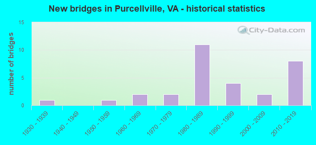
- New bridges - historical statistics
- 11930-1939
- 11950-1959
- 21960-1969
- 21970-1979
- 111980-1989
- 41990-1999
- 22000-2009
- 82010-2019


- Bridge Condition - Deck
- 7.1%Very good
- 64.3%Good
- 28.6%Satisfactory

- Bridge Condition - Superstructure
- 18.8%Very good
- 50.0%Good
- 31.3%Satisfactory

- Bridge Condition - Substructure
- 18.8%Very good
- 56.3%Good
- 25.0%Satisfactory

- Bridge Condition - Channel
- 40.9%Good
- 31.8%Satisfactory
- 18.2%Fair
- 9.1%Poor

- Bridge Condition - Culverts
- 22.2%Very good
- 44.4%Good
- 11.1%Satisfactory
- 22.2%Fair
Find on map >> Show street view
Structure Number: 11011, Location: 00.55FR611/00.40TO722 (Lat: 39.144339, Lng: -77.705111), Route carried "on" structure: County highway F962, Year Built: 1987, Status: Open, Structure Length: 3.20m (10.50ft), Average Daily Traffic: 7,944 (year 2020), Average Future Daily Traffic: 8,738 (year 2040), Design Load: HS 20, Features Intersected: SOUTH FORK CATOCTIN CK., Facility Carried by Structure: HIRST ROAD
Minimum Vertical Clearance: 30+ m (98+ ft), Kilometerpoint: 1.223, Lanes on structure: 2, Owner: State Highway Agency, Approaching Roadway Width: 7.3m (24.0ft), Skew: 2 degrees, Material/Design: Prestressed concrete, Design/Construction: Slab, Number Of Spans In Main Unit: 3, Length of Maximum Span: 10.7m (35.1ft), Curb-To-Curb Width: 9.9m (32.5ft), Out-to-Out Width: 11.0m (36.1ft)
Condition: Deck: Good, Superstructure: Satisfactory, Substructure: Satisfactory, Channel: Satisfactory, Operating Rating: 68.0 metric tons, Method Used To Determine Operating Rating: Load and Resistance Factor (LRFR), Inventory Rating: 52.6 metric tons, Method Used To Determine Inventory Rating: Load and Resistance Factor (LRFR), Structural Evaluation: Equal to present minimum criteria, Deck Geometry: Meets minimum limits, Waterway Adequacy: Equal to present minimum criteria, Approach Roadway Alignment: Equal to present desirable criteria, Length Of Structure Improvement: 0.30m (0.98ft), Designated Inspection Frequency: Every 24 months, Inspection Date: March 2020, Bridge Improvement Cost: $1,000, Roadway Improvement Cost: $1,000, Total Project Cost: $3,000, Deck Structure Type: Concrete Cast-file-Place, Wearing Surface/Protective System: Wearing Surface: Bituminous, Membrane: Preformed Fabric
Find on map >> Show street view
Structure Number: 11061, Location: 02.20FR287/01.85TO7 BUS (Lat: 39.145458, Lng: -77.732297), Route carried "on" structure: State highway 7, Year Built: 1987, Status: Open, Structure Length: 6.40m (21.00ft), Average Daily Traffic: 31,413 (year 2020), Truck Traffic: 3%, Average Future Daily Traffic: 43,978 (year 2040), Design Load: HS 20, Features Intersected: SOUTH FORK CATOCTIN CK.
Minimum Vertical Clearance: 30+ m (98+ ft), Kilometerpoint: 41.593, Lanes on structure: 2, Base Highway Network: Yes, Owner: State Highway Agency, Approaching Roadway Width: 7.3m (24.0ft), Material/Design: Steel, Design/Construction: Stringer/Multi-beam, Number Of Spans In Main Unit: 3, Length of Maximum Span: 21.3m (69.9ft), Curb or Sidewalk Widths: Left: 0.2m (0.7ft), Right: 0.2m (0.7ft), Curb-To-Curb Width: 12.3m (40.4ft), Out-to-Out Width: 13.4m (44.0ft)
Condition: Deck: Good, Superstructure: Satisfactory, Substructure: Satisfactory, Channel: Good, Operating Rating: 98.3 metric tons, Method Used To Determine Operating Rating: Load and Resistance Factor (LRFR), Inventory Rating: 75.8 metric tons, Method Used To Determine Inventory Rating: Load and Resistance Factor (LRFR), Structural Evaluation: Equal to present minimum criteria, Deck Geometry: Somewhat better than minimum adequacy, Waterway Adequacy: Equal to present desirable criteria, Approach Roadway Alignment: Equal to present desirable criteria, Length Of Structure Improvement: 6.46m (21.19ft), Designated Inspection Frequency: Every 24 months, Inspection Date: May 2021, Bridge Improvement Cost: $55,000, Roadway Improvement Cost: $75,000, Total Project Cost: $135,000, Deck Structure Type: Concrete Cast-file-Place, Wearing Surface/Protective System: Deck Protection: Epoxy Coated Reinforcing
Find on map >> Show street view
Structure Number: 11136, Location: 01.30FR9/00.43TO717 (Lat: 39.170336, Lng: -77.686683), Route carried "on" structure: State highway 287, Year Built: 1970, Status: Open, Structure Length: 1.37m (4.49ft), Average Daily Traffic: 5,574 (year 2020), Truck Traffic: 5%, Average Future Daily Traffic: 7,804 (year 2040), Design Load: HS 20+Mod, Features Intersected: S. F. CATOCTIN CREEK, Facility Carried by Structure: BERLIN TURNPIKE
Minimum Vertical Clearance: 30+ m (98+ ft), Kilometerpoint: 3.945, Lanes on structure: 2, Base Highway Network: Yes, Owner: State Highway Agency, Approaching Roadway Width: 9.8m (32.2ft), Skew: 1 degrees, Material/Design: Concrete, Design/Construction: Culvert, Number Of Spans In Main Unit: 4, Length of Maximum Span: 3.0m (9.8ft)
Condition: Channel: Fair, Culverts: Satisfactory, Operating Rating: 73.5 metric tons, Method Used To Determine Operating Rating: Load Factor (LF), Inventory Rating: 43.5 metric tons, Method Used To Determine Inventory Rating: Load Factor (LF), Structural Evaluation: Equal to present minimum criteria, Waterway Adequacy: Equal to present minimum criteria, Approach Roadway Alignment: Better than present minimum criteria, Length Of Structure Improvement: 0.61m (2.00ft), Designated Inspection Frequency: Every 24 months, Inspection Date: March 2021, Bridge Improvement Cost: $20,000, Roadway Improvement Cost: $20,000, Total Project Cost: $41,000
Find on map >> Show street view
Structure Number: 11158, Location: 01.10FR711/00.40TO7 (Lat: 39.142197, Lng: -77.714217), Route carried "on" structure: County highway 611, Year Built: 1987, Status: Open, Structure Length: 1.34m (4.40ft), Average Daily Traffic: 3,819 (year 2020), Truck Traffic: 3%, Average Future Daily Traffic: 5,347 (year 2040), Design Load: HS 20, Features Intersected: S FORK CATACTIN CREEK, Facility Carried by Structure: HATCHER AVE.
Minimum Vertical Clearance: 30+ m (98+ ft), Kilometerpoint: 22.523, Lanes on structure: 2, Owner: Town or Township Highway Agency, Approaching Roadway Width: 11.0m (36.1ft), Material/Design: Concrete, Design/Construction: Culvert, Number Of Spans In Main Unit: 4, Length of Maximum Span: 3.0m (9.8ft)
Condition: Channel: Fair, Culverts: Good, Operating Rating: 63.5 metric tons, Method Used To Determine Operating Rating: Load Factor (LF), Inventory Rating: 38.1 metric tons, Method Used To Determine Inventory Rating: Load Factor (LF), Structural Evaluation: Better than present minimum criteria, Waterway Adequacy: Better than present minimum criteria, Approach Roadway Alignment: Better than present minimum criteria, Length Of Structure Improvement: 5.70m (18.70ft), Designated Inspection Frequency: Every 24 months, Inspection Date: January 2021, Bridge Improvement Cost: $10,000, Roadway Improvement Cost: $20,000, Total Project Cost: $50,000 ( Estimate for 2017)
Find on map >> Show street view
Structure Number: 1116, Location: 00.52FR622/00.05TO794 (Lat: 39.092808, Lng: -77.716475), Route carried "on" structure: County highway 611, Year Built: 1957, Status: Open, Structure Length: 3.93m (12.89ft), Average Daily Traffic: 307 (year 2014), Average Future Daily Traffic: 347 (year 2040), Design Load: HS 20+Mod, Features Intersected: NO. FORK GOOSE CREEK, Facility Carried by Structure: TELEGRAPH SPRGS RD
Minimum Vertical Clearance: 30+ m (98+ ft), Kilometerpoint: 16.557, Lanes on structure: 2, Owner: State Highway Agency, Approaching Roadway Width: 6.1m (20.0ft), Material/Design: Concrete, Design/Construction: Tee Beam, Number Of Spans In Main Unit: 3, Length of Maximum Span: 13.1m (43.0ft), Curb-To-Curb Width: 8.1m (26.6ft), Out-to-Out Width: 9.7m (31.8ft)
Condition: Deck: Satisfactory, Superstructure: Satisfactory, Substructure: Good, Channel: Fair, Operating Rating: 41.7 metric tons, Method Used To Determine Operating Rating: Load and Resistance Factor (LRFR), Inventory Rating: 31.8 metric tons, Method Used To Determine Inventory Rating: Load and Resistance Factor (LRFR), Structural Evaluation: Equal to present minimum criteria, Deck Geometry: Somewhat better than minimum adequacy, Waterway Adequacy: Better than present minimum criteria, Approach Roadway Alignment: Better than present minimum criteria, Length Of Structure Improvement: 0.46m (1.51ft), Designated Inspection Frequency: Every 24 months, Inspection Date: August 2020, Bridge Improvement Cost: $70,000, Roadway Improvement Cost: $70,000, Total Project Cost: $150,000, Deck Structure Type: Concrete Cast-file-Place, Wearing Surface/Protective System: Wearing Surface: Latex Concrete
Find on map >> Show street view
Structure Number: 11164, Location: 00.93FR711/00.57TO7BUS. (Lat: 39.144681, Lng: -77.714164), Route carried "on" structure: County highway 611, Year Built: 1987, Status: Open, Structure Length: 5.85m (19.19ft), Average Daily Traffic: 3,819 (year 2020), Truck Traffic: 3%, Average Future Daily Traffic: 5,347 (year 2040), Design Load: HS 20, Features Intersected: ROUTE 7 BYPASS, Facility Carried by Structure: PURCELLVILLE ROAD
Minimum Vertical Clearance: 30+ m (98+ ft), Kilometerpoint: 22.841, Lanes on structure: 2, Lanes under structure: 4, Owner: State Highway Agency, Approaching Roadway Width: 7.3m (24.0ft), Material/Design: Steel continuous, Design/Construction: Stringer/Multi-beam, Number Of Spans In Main Unit: 2, Length of Maximum Span: 29.3m (96.1ft), Curb-To-Curb Width: 9.9m (32.5ft), Out-to-Out Width: 10.9m (35.8ft)
Condition: Deck: Satisfactory, Superstructure: Satisfactory, Substructure: Satisfactory, Operating Rating: 85.3 metric tons, Method Used To Determine Operating Rating: Load and Resistance Factor (LRFR), Inventory Rating: 65.3 metric tons, Method Used To Determine Inventory Rating: Load and Resistance Factor (LRFR), Structural Evaluation: Equal to present minimum criteria, Deck Geometry: Meets minimum limits, Underclear: Equal to present minimum criteria, Approach Roadway Alignment: Equal to present desirable criteria, Length Of Structure Improvement: 5.85m (19.19ft), Designated Inspection Frequency: Every 24 months, Inspection Date: December 2021, Bridge Improvement Cost: $75,000, Roadway Improvement Cost: $85,000, Total Project Cost: $250,000, Deck Structure Type: Concrete Precast Panels, Wearing Surface/Protective System: Wearing Surface: Monolithic Concrete, Deck Protection: Epoxy Coated Reinforcing
Find on map >> Show street view
Structure Number: 11273, Location: 00.38FR782/01.68TO878 (Lat: 39.109206, Lng: -77.737056), Route carried "on" structure: County highway 690, Year Built: 1932, Status: Open, Structure Length: 1.98m (6.50ft), Average Daily Traffic: 4,073 (year 2020), Truck Traffic: 5%, Average Future Daily Traffic: 5,702 (year 2040), Design Load: H 15, Features Intersected: NORTH FORK GOOSE CREEK, Facility Carried by Structure: SILCOTT SPRINGS RD
Minimum Vertical Clearance: 30+ m (98+ ft), Kilometerpoint: 5.197, Lanes on structure: 2, Owner: State Highway Agency, Approaching Roadway Width: 9.1m (29.9ft), Material/Design: Concrete, Design/Construction: Tee Beam, Number Of Spans In Main Unit: 2, Length of Maximum Span: 10.1m (33.1ft), Curb-To-Curb Width: 8.2m (26.9ft), Out-to-Out Width: 8.8m (28.9ft)
Condition: Deck: Good, Superstructure: Good, Substructure: Satisfactory, Channel: Poor, Operating Rating: 89.8 metric tons, Method Used To Determine Operating Rating: Load and Resistance Factor (LRFR), Inventory Rating: 81.6 metric tons, Method Used To Determine Inventory Rating: Load and Resistance Factor (LRFR), Structural Evaluation: Equal to present minimum criteria, Deck Geometry: High priority of corrective action, Waterway Adequacy: Better than present minimum criteria, Approach Roadway Alignment: Better than present minimum criteria, Length Of Structure Improvement: 1.98m (6.50ft), Designated Inspection Frequency: Every 24 months, Inspection Date: March 2021, Bridge Improvement Cost: $10,000, Roadway Improvement Cost: $5,000, Total Project Cost: $20,000 ( Estimate for 2015), Deck Structure Type: Concrete Cast-file-Place, Wearing Surface/Protective System: Deck Protection: Epoxy Coated Reinforcing
Find on map >> Show street view
Structure Number: 11275, Location: 00.10FR.F962/0.40TOT1604 (Lat: 39.142386, Lng: -77.722622), Route carried "on" structure: County highway 690, Year Built: 1970, Status: Open, Structure Length: 0.98m (3.22ft), Average Daily Traffic: 3,088 (year 2020), Truck Traffic: 4%, Average Future Daily Traffic: 4,323 (year 2040), Design Load: HS 20+Mod, Features Intersected: S. F. OF CATOCTIN CREEK, Facility Carried by Structure: HILLSBORO ROAD
Minimum Vertical Clearance: 30+ m (98+ ft), Kilometerpoint: 11.031, Lanes on structure: 2, Owner: Town or Township Highway Agency, Approaching Roadway Width: 9.1m (29.9ft), Material/Design: Concrete, Design/Construction: Culvert, Number Of Spans In Main Unit: 3, Length of Maximum Span: 3.0m (9.8ft)
Condition: Channel: Fair, Culverts: Fair, Operating Rating: 64.4 metric tons, Method Used To Determine Operating Rating: Load Factor (LF), Inventory Rating: 39.0 metric tons, Method Used To Determine Inventory Rating: Load Factor (LF), Structural Evaluation: Somewhat better than minimum adequacy, Waterway Adequacy: Equal to present minimum criteria, Approach Roadway Alignment: Equal to present minimum criteria, Length Of Structure Improvement: 3.05m (10.01ft), Designated Inspection Frequency: Every 24 months, Inspection Date: January 2021, Bridge Improvement Cost: $10,000, Roadway Improvement Cost: $10,000, Total Project Cost: $25,000 ( Estimate for 2017)
Find on map >> Show street view
Structure Number: 11281, Location: 01.19FR711/00.15TO F962 (Lat: 39.144800, Lng: -77.724900), Route carried "on" structure: County highway 690, Year Built: 1987, Status: Open, Structure Length: 8.96m (29.40ft), Average Daily Traffic: 5,085 (year 2020), Truck Traffic: 5%, Average Future Daily Traffic: 7,119 (year 2040), Design Load: HS 20, Features Intersected: ROUTE 7 BYPASS, Facility Carried by Structure: HILLSBORO ROAD
Minimum Vertical Clearance: 30+ m (98+ ft), Kilometerpoint: 10.821, Lanes on structure: 2, Lanes under structure: 4, Owner: State Highway Agency, Approaching Roadway Width: 11.6m (38.1ft), Skew: 3 degrees, Material/Design: Steel continuous, Design/Construction: Stringer/Multi-beam, Number Of Spans In Main Unit: 2, Length of Maximum Span: 44.8m (147.0ft), Curb or Sidewalk Widths: Left: 0.0m, Right: 1.5m (4.9ft), Curb-To-Curb Width: 9.8m (32.2ft), Out-to-Out Width: 12.2m (40.0ft)
Condition: Deck: Good, Superstructure: Good, Substructure: Good, Inventory Rating: 88.9 metric tons, Method Used To Determine Inventory Rating: Load and Resistance Factor (LRFR), Structural Evaluation: Better than present minimum criteria, Deck Geometry: Meets minimum limits, Underclear: Equal to present minimum criteria, Approach Roadway Alignment: Equal to present desirable criteria, Length Of Structure Improvement: 8.96m (29.40ft), Designated Inspection Frequency: Every 24 months, Inspection Date: December 2021, Bridge Improvement Cost: $50,000, Roadway Improvement Cost: $150,000, Total Project Cost: $250,000, Deck Structure Type: Concrete Cast-file-Place, Wearing Surface/Protective System: Wearing Surface: Monolithic Concrete, Deck Protection: Epoxy Coated Reinforcing
Find on map >> Show street view
Structure Number: 1133, Location: 01.70FR.727/00.85TO728 (Lat: 39.074358, Lng: -77.698506), Route carried "on" structure: County highway 722, Year Built: 1967, Status: Open, Structure Length: 0.61m (2.00ft), Average Daily Traffic: 1,075 (year 2014), Average Future Daily Traffic: 1,239 (year 2040), Design Load: HS 20, Features Intersected: TRIB. OF N.FORK GOOSE CR, Facility Carried by Structure: LINCOLN ROAD
Minimum Vertical Clearance: 30+ m (98+ ft), Kilometerpoint: 2.763, Lanes on structure: 2, Owner: State Highway Agency, Approaching Roadway Width: 5.5m (18.0ft), Skew: 4 degrees, Material/Design: Concrete, Design/Construction: Culvert, Number Of Spans In Main Unit: 2, Length of Maximum Span: 3.0m (9.8ft)
Condition: Channel: Good, Culverts: Good, Operating Rating: 89.8 metric tons, Method Used To Determine Operating Rating: Load Factor (LF), Inventory Rating: 61.7 metric tons, Method Used To Determine Inventory Rating: Load Factor (LF), Structural Evaluation: Better than present minimum criteria, Waterway Adequacy: Better than present minimum criteria, Approach Roadway Alignment: Equal to present minimum criteria, Length Of Structure Improvement: 2.74m (8.99ft), Designated Inspection Frequency: Every 24 months, Inspection Date: September 2021, Bridge Improvement Cost: $33,000, Roadway Improvement Cost: $45,000, Total Project Cost: $100,000
Find on map >> Show street view
Structure Number: 11333, Location: 01.20FR728/01.50TO727 (Lat: 39.076867, Lng: -77.697142), Route carried "on" structure: County highway 722, Year Built: 1968, Status: Open, Structure Length: 3.11m (10.20ft), Average Daily Traffic: 1,075 (year 2014), Average Future Daily Traffic: 1,239 (year 2040), Design Load: HS 20, Features Intersected: NORTH FORK GOOSE CREEK, Facility Carried by Structure: LINCOLN RD.
Minimum Vertical Clearance: 30+ m (98+ ft), Kilometerpoint: 3.395, Lanes on structure: 2, Owner: State Highway Agency, Approaching Roadway Width: 5.5m (18.0ft), Skew: 3 degrees, Material/Design: Steel, Design/Construction: Stringer/Multi-beam, Number Of Spans In Main Unit: 2, Length of Maximum Span: 15.5m (50.9ft), Curb or Sidewalk Widths: Left: 0.2m (0.7ft), Right: 0.2m (0.7ft), Curb-To-Curb Width: 8.2m (26.9ft), Out-to-Out Width: 8.8m (28.9ft)
Condition: Deck: Satisfactory, Superstructure: Satisfactory, Substructure: Good, Channel: Satisfactory, Operating Rating: 90.6 metric tons, Method Used To Determine Operating Rating: Load and Resistance Factor (LRFR), Inventory Rating: 70.8 metric tons, Method Used To Determine Inventory Rating: Load and Resistance Factor (LRFR), Structural Evaluation: Equal to present minimum criteria, Deck Geometry: Meets minimum limits, Waterway Adequacy: Better than present minimum criteria, Approach Roadway Alignment: Equal to present desirable criteria, Length Of Structure Improvement: 3.11m (10.20ft), Designated Inspection Frequency: Every 24 months, Inspection Date: March 2021, Bridge Improvement Cost: $99,000, Roadway Improvement Cost: $99,000, Total Project Cost: $200,000, Deck Structure Type: Concrete Cast-file-Place
Find on map >> Show street view
Structure Number: 23851, Location: 00.90FR782N/00.25TO782S (Lat: 39.125294, Lng: -77.738528), Route carried "on" structure: County highway 1150, Year Built: 1989, Status: Open, Structure Length: 0.88m (2.89ft), Average Daily Traffic: 174 (year 2014), Average Future Daily Traffic: 197 (year 2040), Design Load: HS 20, Features Intersected: TRIB. OF JACKS RUN, Facility Carried by Structure: INNISBROOK CIRCLE
Minimum Vertical Clearance: 30+ m (98+ ft), Kilometerpoint: 0.000, Lanes on structure: 2, Owner: State Highway Agency, Approaching Roadway Width: 6.7m (22.0ft), Skew: 4 degrees, Material/Design: Concrete, Design/Construction: Culvert, Number Of Spans In Main Unit: 3, Length of Maximum Span: 2.1m (6.9ft)
Condition: Channel: Poor, Culverts: Fair, Operating Rating: 32.7 metric tons, Method Used To Determine Operating Rating: Load Factor (LF), Inventory Rating: 32.6 metric tons, Method Used To Determine Inventory Rating: Load Factor (LF), Structural Evaluation: Somewhat better than minimum adequacy, Waterway Adequacy: Better than present minimum criteria, Approach Roadway Alignment: Better than present minimum criteria, Length Of Structure Improvement: 7.13m (23.39ft), Designated Inspection Frequency: Every 24 months, Inspection Date: May 2020, Bridge Improvement Cost: $40,000, Roadway Improvement Cost: $75,000, Total Project Cost: $150,000 ( Estimate for 2014)
Find on map >> Show street view
Structure Number: 24189, Location: 03.10FR7BUS/00.70TO287 (Lat: 39.144647, Lng: -77.704811), Route carried "on" structure: Bypass State highway 7, Year Built: 1995, Status: Open, Structure Length: 5.49m (18.01ft), Average Daily Traffic: 15,706 (year 2020), Truck Traffic: 3%, Average Future Daily Traffic: 21,990 (year 2040), Design Load: HS 20, Features Intersected: SOUTH FORK CATOCTIN CK.
Minimum Vertical Clearance: 30+ m (98+ ft), Kilometerpoint: 43.974, Lanes on structure: 2, Base Highway Network: Yes, Owner: State Highway Agency, Approaching Roadway Width: 12.2m (40.0ft), Skew: 4 degrees, Material/Design: Steel, Design/Construction: Stringer/Multi-beam, Number Of Spans In Main Unit: 3, Length of Maximum Span: 18.3m (60.0ft), Curb-To-Curb Width: 12.3m (40.4ft), Out-to-Out Width: 13.4m (44.0ft)
Condition: Deck: Good, Superstructure: Good, Substructure: Good, Channel: Good, Operating Rating: 89.8 metric tons, Method Used To Determine Operating Rating: Load and Resistance Factor (LRFR), Inventory Rating: 72.6 metric tons, Method Used To Determine Inventory Rating: Load and Resistance Factor (LRFR), Structural Evaluation: Better than present minimum criteria, Deck Geometry: Better than present minimum criteria, Waterway Adequacy: Equal to present desirable criteria, Approach Roadway Alignment: Equal to present desirable criteria, Length Of Structure Improvement: 5.55m (18.21ft), Designated Inspection Frequency: Every 24 months, Inspection Date: May 2021, Bridge Improvement Cost: $55,000, Roadway Improvement Cost: $95,000, Total Project Cost: $160,000, Deck Structure Type: Concrete Cast-file-Place, Wearing Surface/Protective System: Deck Protection: Epoxy Coated Reinforcing
Find on map >> Show street view
Structure Number: 24195, Location: 02.20FR704___04.05TO7 (Lat: 39.144442, Lng: -77.691897), Route carried "on" structure: Bypass State highway 7, Year Built: 1995, Status: Open, Structure Length: 6.31m (20.70ft), Average Daily Traffic: 15,706 (year 2020), Truck Traffic: 3%, Average Future Daily Traffic: 21,990 (year 2040), Design Load: HS 20, Features Intersected: BERLIN TPKE; ROUTE 287
Minimum Vertical Clearance: 30+ m (98+ ft), Kilometerpoint: 45.052, Lanes on structure: 2, Lanes under structure: 3, Base Highway Network: Yes, Owner: State Highway Agency, Approaching Roadway Width: 7.3m (24.0ft), Material/Design: Steel, Design/Construction: Stringer/Multi-beam, Number Of Spans In Main Unit: 3, Length of Maximum Span: 38.1m (125.0ft), Curb-To-Curb Width: 11.7m (38.4ft), Out-to-Out Width: 12.7m (41.7ft)
Condition: Deck: Good, Superstructure: Good, Substructure: Good, Operating Rating: 76.0 metric tons, Method Used To Determine Operating Rating: Load and Resistance Factor (LRFR), Inventory Rating: 58.7 metric tons, Method Used To Determine Inventory Rating: Load and Resistance Factor (LRFR), Structural Evaluation: Better than present minimum criteria, Deck Geometry: Better than present minimum criteria, Underclear: Equal to present minimum criteria, Approach Roadway Alignment: Equal to present desirable criteria, Length Of Structure Improvement: 6.31m (20.70ft), Designated Inspection Frequency: Every 24 months, Inspection Date: May 2021, Bridge Improvement Cost: $65,000, Roadway Improvement Cost: $125,000, Total Project Cost: $200,000 ( Estimate for 2015), Deck Structure Type: Concrete Cast-file-Place, Wearing Surface/Protective System: Deck Protection: Epoxy Coated Reinforcing
Find on map >> Show street view
Structure Number: 25516, Location: 01.20FR728/00.40TO622 (Lat: 39.082989, Lng: -77.726497), Route carried "on" structure: County highway 611, Year Built: 1998, Status: Open, Structure Length: 1.07m (3.51ft), Average Daily Traffic: 175 (year 2014), Average Future Daily Traffic: 198 (year 2040), Design Load: HS 20, Features Intersected: TRIB.OF GOOSE CREEK, Facility Carried by Structure: TELEGRAPH SPRING
Minimum Vertical Clearance: 30+ m (98+ ft), Kilometerpoint: 15.044, Lanes on structure: 2, Owner: State Highway Agency, Approaching Roadway Width: 4.0m (13.1ft), Material/Design: Concrete, Design/Construction: Slab, Number Of Spans In Main Unit: 1, Length of Maximum Span: 10.4m (34.1ft), Curb-To-Curb Width: 6.1m (20.0ft), Out-to-Out Width: 6.7m (22.0ft)
Condition: Deck: Satisfactory, Superstructure: Good, Substructure: Good, Channel: Satisfactory, Operating Rating: 89.8 metric tons, Method Used To Determine Operating Rating: Load and Resistance Factor (LRFR), Inventory Rating: 68.9 metric tons, Method Used To Determine Inventory Rating: Load and Resistance Factor (LRFR), Structural Evaluation: Better than present minimum criteria, Deck Geometry: Meets minimum limits, Waterway Adequacy: Equal to present minimum criteria, Approach Roadway Alignment: Better than present minimum criteria, Length Of Structure Improvement: 0.30m (0.98ft), Designated Inspection Frequency: Every 24 months, Inspection Date: August 2020, Bridge Improvement Cost: $50,000, Roadway Improvement Cost: $50,000, Total Project Cost: $125,000, Deck Structure Type: Concrete Cast-file-Place, Wearing Surface/Protective System: Wearing Surface: Gravel, Deck Protection: Epoxy Coated Reinforcing
Find on map >> Show street view
Structure Number: 27928, Location: 01.00FR728/00.80TO841 (Lat: 39.072575, Lng: -77.683625), Route carried "on" structure: County highway 729, Year Built: 2004, Status: Open, Structure Length: 2.80m (9.19ft), Average Daily Traffic: 174 (year 2014), Average Future Daily Traffic: 264 (year 2040), Design Load: HS 20+Mod, Features Intersected: NORTH FORK GOOSE CREEK, Facility Carried by Structure: SHELBURN GLEBE RD.
Minimum Vertical Clearance: 30+ m (98+ ft), Kilometerpoint: 3.009, Lanes on structure: 2, Owner: State Highway Agency, Approaching Roadway Width: 7.0m (23.0ft), Material/Design: Steel, Design/Construction: Truss - Thru, Number Of Spans In Main Unit: 1, Length of Maximum Span: 27.1m (88.9ft), Curb-To-Curb Width: 6.1m (20.0ft), Out-to-Out Width: 6.1m (20.0ft)
Condition: Deck: Good, Superstructure: Good, Substructure: Good, Channel: Satisfactory, Operating Rating: 52.6 metric tons, Method Used To Determine Operating Rating: Load Factor (LF), Inventory Rating: 30.8 metric tons, Method Used To Determine Inventory Rating: Load Factor (LF), Structural Evaluation: Better than present minimum criteria, Deck Geometry: Meets minimum limits, Waterway Adequacy: Equal to present desirable criteria, Approach Roadway Alignment: Superior to present desirable criteria, Length Of Structure Improvement: 2.71m (8.89ft), Designated Inspection Frequency: Every 24 months, Critical Feature Inspection Frequency: Every 24 months, Inspection Date: March 2020, Critical Feature Inspection Date: March 2020, Bridge Improvement Cost: $30,000, Roadway Improvement Cost: $75,000, Total Project Cost: $125,000 ( Estimate for 2015), Deck Structure Type: Concrete Cast-file-Place
Find on map >> Show street view
Structure Number: 28135, Location: 00.30FR611/00.10TOWALNUT (Lat: 39.117611, Lng: -77.715250), Route carried "on" structure: County highway 1165, Year Built: 2005, Status: Open, Structure Length: 1.03m (3.38ft), Average Daily Traffic: 50 (year 2018), Truck Traffic: 1%, Average Future Daily Traffic: 120 (year 2042), Design Load: HS 20, Features Intersected: TRIB.OF NORTH FORK GOOSE, Facility Carried by Structure: FRANKLIN FORD PL.
Minimum Vertical Clearance: 30.18m (99.02ft), Kilometerpoint: 0.000, Lanes on structure: 2, Owner: State Highway Agency, Approaching Roadway Width: 8.2m (26.9ft), Material/Design: Concrete, Design/Construction: Arch - Deck, Number Of Spans In Main Unit: 1, Length of Maximum Span: 9.8m (32.2ft), Curb-To-Curb Width: 7.3m (24.0ft), Out-to-Out Width: 17.7m (58.1ft)
Condition: Superstructure: Very good, Substructure: Very good, Channel: Good, Operating Rating: 75.6 metric tons, Method Used To Determine Operating Rating: Load and Resistance Factor (LRFR), Inventory Rating: 58.6 metric tons, Method Used To Determine Inventory Rating: Load and Resistance Factor (LRFR), Structural Evaluation: Equal to present desirable criteria, Deck Geometry: Equal to present minimum criteria, Waterway Adequacy: Better than present minimum criteria, Approach Roadway Alignment: Better than present minimum criteria, Designated Inspection Frequency: Every 24 months, Inspection Date: Febuary 2021, Deck Structure Type: Concrete Precast Panels
Find on map >> Show street view
Structure Number: 29942, Location: 0.50fr287 0.20to Carmica (Lat: 39.149886, Lng: -77.700083), Route carried "on" structure: County highway 3191, Year Built: 2012, Status: Open, Structure Length: 2.77m (9.09ft), Average Daily Traffic: 200 (year 2012), Truck Traffic: 1%, Average Future Daily Traffic: 500 (year 2031), Design Load: HS 20, Features Intersected: SOUTH FORK CATOCTIN, Facility Carried by Structure: WRIGHT FARM DRIVE
Minimum Vertical Clearance: 30.18m (99.02ft), Kilometerpoint: 0.000, Lanes on structure: 2, Owner: State Highway Agency, Approaching Roadway Width: 7.3m (24.0ft), Material/Design: Concrete, Design/Construction: Arch - Deck, Number Of Spans In Main Unit: 3, Length of Maximum Span: 9.8m (32.2ft), Curb-To-Curb Width: 7.3m (24.0ft), Out-to-Out Width: 20.1m (65.9ft)
Condition: Superstructure: Good, Substructure: Good, Channel: Satisfactory, Operating Rating: 69.4 metric tons, Method Used To Determine Operating Rating: Load and Resistance Factor (LRFR), Inventory Rating: 55.4 metric tons, Method Used To Determine Inventory Rating: Load and Resistance Factor (LRFR), Structural Evaluation: Better than present minimum criteria, Deck Geometry: Somewhat better than minimum adequacy, Waterway Adequacy: Equal to present desirable criteria, Approach Roadway Alignment: Better than present minimum criteria, Designated Inspection Frequency: Every 24 months, Inspection Date: October 2021
Find on map >> Show street view
Structure Number: 30064, Location: 00.70fr722 00.21to 7 (Lat: 39.133275, Lng: -77.692544), Route carried "on" structure: Alternate County highway 1610, Year Built: 2012, Status: Open, Structure Length: 0.82m (2.69ft), Average Daily Traffic: 300 (year 2012), Truck Traffic: 1%, Average Future Daily Traffic: 700 (year 2034), Design Load: HS 20, Features Intersected: Trib of Crooked run, Facility Carried by Structure: W.T. Druhan Blvd.
Minimum Vertical Clearance: 30.18m (99.02ft), Kilometerpoint: 0.000, Lanes on structure: 2, Owner: Town or Township Highway Agency, Approaching Roadway Width: 8.2m (26.9ft), Skew: 4 degrees, Material/Design: Concrete, Design/Construction: Culvert, Number Of Spans In Main Unit: 3, Length of Maximum Span: 2.4m (7.9ft)
Condition: Channel: Good, Culverts: Good, Operating Rating: 89.8 metric tons, Method Used To Determine Operating Rating: Load Factor (LF), Inventory Rating: 89.7 metric tons, Method Used To Determine Inventory Rating: Load Factor (LF), Structural Evaluation: Better than present minimum criteria, Waterway Adequacy: Equal to present minimum criteria, Approach Roadway Alignment: Better than present minimum criteria, Length Of Structure Improvement: 0.30m (0.98ft), Designated Inspection Frequency: Every 24 months, Inspection Date: May 2020, Bridge Improvement Cost: $1,000, Roadway Improvement Cost: $1,000, Total Project Cost: $3,000 ( Estimate for 2016)
Find on map >> Show street view
Structure Number: 30112, Location: 00.62fr722 00.04to841 _ (Lat: 39.092042, Lng: -77.682450), Route carried "on" structure: Alternate County highway 727, Year Built: 2017, Status: Open, Structure Length: 2.13m (6.99ft), Average Daily Traffic: 93 (year 2014), Truck Traffic: 2%, Average Future Daily Traffic: 141 (year 2040), Design Load: HS 20, Features Intersected: TRIB OF CROOKED RUN, Facility Carried by Structure: FOREST MILLS ROAD
Minimum Vertical Clearance: 30.18m (99.02ft), Kilometerpoint: 0.000, Lanes on structure: 1, Owner: State Highway Agency, Approaching Roadway Width: 3.7m (12.1ft), Material/Design: Prestressed concrete, Design/Construction: Slab, Number Of Spans In Main Unit: 2, Length of Maximum Span: 9.4m (30.8ft), Curb-To-Curb Width: 3.7m (12.1ft), Out-to-Out Width: 5.2m (17.1ft)
Condition: Deck: Good, Superstructure: Very good, Substructure: Very good, Channel: Good, Operating Rating: 66.2 metric tons, Method Used To Determine Operating Rating: Load and Resistance Factor (LRFR), Inventory Rating: 50.8 metric tons, Method Used To Determine Inventory Rating: Load and Resistance Factor (LRFR), Structural Evaluation: Equal to present desirable criteria, Deck Geometry: Meets minimum limits, Waterway Adequacy: High priority of corrective action, Approach Roadway Alignment: Better than present minimum criteria, Designated Inspection Frequency: Every 24 months, Inspection Date: October 2021, Deck Structure Type: Concrete Precast Panels, Wearing Surface/Protective System: Wearing Surface: Bituminous, Membrane: Preformed Fabric
Find on map >> Show street view
Structure Number: 30183, Location: .04W20thSt./.69SMainSt. (Lat: 39.126944, Lng: -77.713056), Route carried "on" structure: City street 1610, Year Built: 2012, Status: Open, Structure Length: 0.79m (2.59ft), Average Daily Traffic: 600 (year 2012), Average Future Daily Traffic: 750 (year 2035), Design Load: HS 20, Features Intersected: Unknown Waterway, Facility Carried by Structure: EAST A STREET
Minimum Vertical Clearance: 30.45m (99.90ft), Kilometerpoint: 0.000, Lanes on structure: 2, Owner: Town or Township Highway Agency, Approaching Roadway Width: 7.9m (25.9ft), Material/Design: Concrete, Design/Construction: Culvert, Number Of Spans In Main Unit: 4, Length of Maximum Span: 1.8m (5.9ft)
Condition: Channel: Good, Culverts: Good, Operating Rating: 44.5 metric tons, Method Used To Determine Operating Rating: Field evaluation and documented engineering judgment, Inventory Rating: 32.7 metric tons, Method Used To Determine Inventory Rating: Field evaluation and documented engineering judgment, Structural Evaluation: Better than present minimum criteria, Waterway Adequacy: Better than present minimum criteria, Approach Roadway Alignment: Equal to present minimum criteria, Length Of Structure Improvement: 0.30m (0.98ft), Designated Inspection Frequency: Every 24 months, Inspection Date: January 2021, Bridge Improvement Cost: $1,000, Roadway Improvement Cost: $1,000, Total Project Cost: $3,000 ( Estimate for 2017)
Find on map >> Show street view
Structure Number: 30184, Location: .48S.Main St/.03W.20thSt (Lat: 39.129786, Lng: -77.713728), Route carried "on" structure: City street , Year Built: 2012, Status: Open, Structure Length: 0.73m (2.40ft), Average Daily Traffic: 600 (year 2012), Average Future Daily Traffic: 720 (year 2035), Design Load: HS 20, Features Intersected: S.Fork of Catoctin Creek, Facility Carried by Structure: LOCUST GROVE DRIVE
Minimum Vertical Clearance: 30+ m (98+ ft), Kilometerpoint: 0.000, Lanes on structure: 2, Owner: Town or Township Highway Agency, Approaching Roadway Width: 9.1m (29.9ft), Material/Design: Concrete, Design/Construction: Arch - Deck, Number Of Spans In Main Unit: 1, Length of Maximum Span: 7.3m (24.0ft), Curb or Sidewalk Widths: Left: 1.2m (3.9ft), Right: 1.2m (3.9ft), Curb-To-Curb Width: 9.1m (29.9ft), Out-to-Out Width: 25.9m (85.0ft)
Condition: Deck: Good, Superstructure: Good, Substructure: Good, Channel: Good, Operating Rating: 77.0 metric tons, Method Used To Determine Operating Rating: Load and Resistance Factor (LRFR), Inventory Rating: 59.4 metric tons, Method Used To Determine Inventory Rating: Load and Resistance Factor (LRFR), Structural Evaluation: Better than present minimum criteria, Deck Geometry: Equal to present minimum criteria, Waterway Adequacy: Better than present minimum criteria, Approach Roadway Alignment: Equal to present minimum criteria, Length Of Structure Improvement: 0.30m (0.98ft), Designated Inspection Frequency: Every 24 months, Inspection Date: January 2021, Bridge Improvement Cost: $1,000, Roadway Improvement Cost: $1,000, Total Project Cost: $3,000 ( Estimate for 2017)
Find on map >> Show street view
Structure Number: 30728, Location: 00.85fr611 00.40to287_ (Lat: 39.159069, Lng: -77.698383), Route carried "on" structure: Alternate County highway 711, Year Built: 2016, Status: Open, Structure Length: 0.70m (2.30ft), Average Daily Traffic: 291 (year 2014), Average Future Daily Traffic: 329 (year 2040), Design Load: HS 20, Features Intersected: SOUTH FORK CATOCTIN CK, Facility Carried by Structure: ALLDER SCHOOL ROAD
Minimum Vertical Clearance: 30.18m (99.02ft), Kilometerpoint: 0.000, Lanes on structure: 2, Owner: State Highway Agency, Approaching Roadway Width: 6.1m (20.0ft), Material/Design: Concrete, Design/Construction: Culvert, Number Of Spans In Main Unit: 3, Length of Maximum Span: 1.5m (4.9ft)
Condition: Channel: Satisfactory, Culverts: Very good, Operating Rating: 44.5 metric tons, Method Used To Determine Operating Rating: Load Factor (LF), Inventory Rating: 32.7 metric tons, Method Used To Determine Inventory Rating: Load Factor (LF), Structural Evaluation: Equal to present desirable criteria, Waterway Adequacy: Somewhat better than minimum adequacy, Approach Roadway Alignment: Somewhat better than minimum adequacy, Designated Inspection Frequency: Every 24 months, Inspection Date: March 2020
Find on map >> Show street view
Structure Number: 30989, Location: 00.10FR716/01.10TO719 (Lat: 39.159161, Lng: -77.748314), Route carried "on" structure: County highway 711, Year Built: 2018, Status: Open, Structure Length: 1.52m (4.99ft), Average Daily Traffic: 40,718 (year 2020), Truck Traffic: 1%, Average Future Daily Traffic: 44,790 (year 2040), Design Load: HL 93, Features Intersected: SOUTH FORK CATOCTIN CK., Facility Carried by Structure: ALLDER SCHOOL ROAD
Minimum Vertical Clearance: 30+ m (98+ ft), Kilometerpoint: 9.445, Lanes on structure: 2, Owner: State Highway Agency, Approaching Roadway Width: 9.1m (29.9ft), Skew: 2 degrees, Material/Design: Prestressed concrete, Design/Construction: Stringer/Multi-beam, Number Of Spans In Main Unit: 1, Length of Maximum Span: 13.1m (43.0ft), Curb-To-Curb Width: 9.8m (32.2ft), Out-to-Out Width: 10.4m (34.1ft)
Condition: Deck: Very good, Superstructure: Very good, Substructure: Very good, Channel: Good, Operating Rating: 72.8 metric tons, Method Used To Determine Operating Rating: Load and Resistance Factor (LRFR), Inventory Rating: 56.2 metric tons, Method Used To Determine Inventory Rating: Load and Resistance Factor (LRFR), Structural Evaluation: Equal to present desirable criteria, Deck Geometry: Meets minimum limits, Waterway Adequacy: Better than present minimum criteria, Approach Roadway Alignment: Better than present minimum criteria, Designated Inspection Frequency: Every 24 months, Inspection Date: May 2020, Bridge Improvement Cost: $1,000, Roadway Improvement Cost: $1,000, Total Project Cost: $3,000 ( Estimate for 2016), Deck Structure Type: Concrete Cast-file-Place, Wearing Surface/Protective System: Wearing Surface: Monolithic Concrete, Deck Protection: Other
Find on map >> Show street view
Structure Number: 31124, Location: 00.70 690 / 00.60 611 (Lat: 39.160706, Lng: -77.723133), Route carried "on" structure: County highway 711, Year Built: 2018, Status: Open, Structure Length: 1.05m (3.44ft), Average Daily Traffic: 2,086 (year 2014), Average Future Daily Traffic: 2,743 (year 2035), Design Load: HS 20, Features Intersected: TRIB. OF SF CATOCTIN CK., Facility Carried by Structure: ALLDER SCHOOL ROAD
Minimum Vertical Clearance: 30+ m (98+ ft), Kilometerpoint: 11.537, Lanes on structure: 2, Owner: State Highway Agency, Approaching Roadway Width: 6.1m (20.0ft), Skew: 2 degrees, Material/Design: Concrete, Design/Construction: Culvert, Number Of Spans In Main Unit: 3, Length of Maximum Span: 2.7m (8.9ft)
Condition: Channel: Satisfactory, Culverts: Very good, Operating Rating: 65.3 metric tons, Method Used To Determine Operating Rating: Load Factor (LF), Inventory Rating: 39.0 metric tons, Method Used To Determine Inventory Rating: Load Factor (LF), Structural Evaluation: Equal to present desirable criteria, Waterway Adequacy: Equal to present desirable criteria, Approach Roadway Alignment: Better than present minimum criteria, Length Of Structure Improvement: 4.51m (14.80ft), Designated Inspection Frequency: Every 24 months, Inspection Date: June 2020, Bridge Improvement Cost: $15,000, Roadway Improvement Cost: $25,000, Total Project Cost: $50,000 ( Estimate for 2015)
Find on map >> Show street view
Structure Number: 11063, Location: 02.20FR704/04.05TO7 BUS. (Lat: 39.144672, Lng: -77.691861), Route carried "under" structure: State highway 287, Year Built: 1987, Structure Length: 0. m, Average Daily Traffic: 4,737 (year 2008), Truck Traffic: 3%, Features Intersected: BERLIN TURNPIKE RTE. 287, Facility Carried by Structure: ROUTE 7 BYPASS
Minimum Vertical Clearance: 5.05m (16.57ft), Kilometerpoint: 0.998, Lanes on structure: 2, Lanes under structure: 3, Material/Design: Steel, Design/Construction: Stringer/Multi-beam, Length of Maximum Span: 38.1m (125.0ft)
Find on map >> Show street view
Structure Number: 11164, Location: 00.93FR711/00.57TO7BUS. (Lat: 39.144681, Lng: -77.714164), Route carried "under" structure: State highway 7, Year Built: 1987, Structure Length: 0. m, Average Daily Traffic: 24,536 (year 2008), Truck Traffic: 2%, Features Intersected: ROUTE 7 BYPASS, Facility Carried by Structure: PURCELLVILLE ROAD
Minimum Vertical Clearance: 5.13m (16.83ft), Kilometerpoint: 43.089, Lanes on structure: 2, Lanes under structure: 2, Material/Design: Steel continuous, Design/Construction: Stringer/Multi-beam, Length of Maximum Span: 29.3m (96.1ft)
Find on map >> Show street view
Structure Number: 11164, Location: 00.93FR711/00.57TO7BUS. (Lat: 39.144681, Lng: -77.714164), Route carried "under" structure: State highway 7, Year Built: 1987, Structure Length: 0. m, Average Daily Traffic: 16,000 (year 2003), Features Intersected: ROUTE 7 BYPASS, Facility Carried by Structure: PURCELLVILLE ROAD
Minimum Vertical Clearance: 5.21m (17.09ft), Kilometerpoint: 43.089, Lanes on structure: 2, Lanes under structure: 2, Material/Design: Steel continuous, Design/Construction: Stringer/Multi-beam, Length of Maximum Span: 29.3m (96.1ft)
Find on map >> Show street view
Structure Number: 11281, Location: 01.19FR711/00.15TO F962 (Lat: 39.144800, Lng: -77.724900), Route carried "under" structure: State highway 7, Year Built: 1987, Structure Length: 0. m, Average Daily Traffic: 24,536 (year 2008), Truck Traffic: 2%, Features Intersected: ROUTE 7 BYPASS, Facility Carried by Structure: HILLSBORO ROAD
Minimum Vertical Clearance: 5.03m (16.50ft), Kilometerpoint: 42.140, Lanes on structure: 2, Lanes under structure: 2, Material/Design: Steel continuous, Design/Construction: Stringer/Multi-beam, Length of Maximum Span: 44.8m (147.0ft)
Find on map >> Show street view
Structure Number: 11281, Location: 01.19FR711/00.15TO F962 (Lat: 39.144800, Lng: -77.724900), Route carried "under" structure: State highway 7, Year Built: 1987, Structure Length: 0. m, Average Daily Traffic: 16,000 (year 2003), Features Intersected: ROUTE 7 BYPASS, Facility Carried by Structure: HILLSBORO ROAD
Minimum Vertical Clearance: 5.31m (17.42ft), Kilometerpoint: 42.140, Lanes on structure: 2, Lanes under structure: 2, Material/Design: Steel continuous, Design/Construction: Stringer/Multi-beam, Length of Maximum Span: 44.8m (147.0ft)
Find on map >> Show street view
Structure Number: 24195, Location: 02.20FR704___04.05TO7 (Lat: 39.144442, Lng: -77.691897), Route carried "under" structure: State highway 287, Year Built: 1995, Structure Length: 0. m, Average Daily Traffic: 4,737 (year 2008), Truck Traffic: 3%, Features Intersected: BERLIN TPKE; ROUTE 287, Facility Carried by Structure: ROUTE 7 BP; EBL
Minimum Vertical Clearance: 5.26m (17.26ft), Kilometerpoint: 0.965, Lanes on structure: 2, Lanes under structure: 3, Material/Design: Steel, Design/Construction: Stringer/Multi-beam, Length of Maximum Span: 38.1m (125.0ft)