Bridge Statistics for Priceville, Alabama (AL)
Condition, Traffic, Stress, Structural Evaluation, Project Costs
- National Bridge Inventory (NBI) Statistics
- 11Number of bridges
- 125ft / 38.2mTotal length
- $13,232,000Total costs
- 110,340Total average daily traffic
- 22,996Total average daily truck traffic
- National Bridge Inventory (NBI) Registered Bridges for Priceville
- No street view available for this location
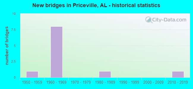
- New bridges - historical statistics
- 11950-1959
- 81960-1969
- 11980-1989
- 12010-2019

- Reconstructed bridges - Historical Statistics
- 11960-1969
- 11970-1979


- Bridge Condition - Deck
- 16.7%Good
- 66.7%Satisfactory
- 16.7%Fair

- Bridge Condition - Superstructure
- 83.3%Good
- 16.7%Satisfactory

- Bridge Condition - Substructure
- 50.0%Good
- 33.3%Satisfactory
- 16.7%Fair

- Bridge Condition - Channel
- 20.0%Good
- 40.0%Satisfactory
- 40.0%Fair

- Bridge Condition - Culverts
- 50.0%Very good
- 50.0%Good
Find on map >> Show street view
Structure Number: 43660-00015, Location: TRUCK TRAIL RD @ BLACK BR (Lat: 34.554667, Lng: -86.878833), Route carried "on" structure: Federal lands road , Year Built: 1960, Year Reconstructed: 1970, Status: Posted for load, Structure Length: 0.88m (2.89ft), Average Daily Traffic: 15 (year 2021), Average Future Daily Traffic: 20 (year 2041), Features Intersected: BLACK BRANCH, Facility Carried by Structure: TRUCK TRAIL ROAD
Minimum Vertical Clearance: 30.48m (100.00ft), Kilometerpoint: 11.426, Lanes on structure: 1, Owner: Bureau of Fish and Wildlife, Approaching Roadway Width: 3.7m (12.1ft), Material/Design: Steel continuous, Design/Construction: Stringer/Multi-beam, Number Of Spans In Main Unit: 2, Length of Maximum Span: 4.0m (13.1ft), Curb-To-Curb Width: 4.1m (13.5ft), Out-to-Out Width: 4.1m (13.5ft)
Condition: Deck: Satisfactory, Superstructure: Good, Substructure: Satisfactory, Channel: Satisfactory, Operating Rating: 10.9 metric tons, Method Used To Determine Operating Rating: Allowable Stress (AS), Inventory Rating: 8.2 metric tons, Method Used To Determine Inventory Rating: Allowable Stress (AS), Structural Evaluation: High priority of corrective action, Deck Geometry: Somewhat better than minimum adequacy, Waterway Adequacy: Equal to present minimum criteria, Approach Roadway Alignment: Better than present minimum criteria, Bridge Posting: Required (Relationship of Operating Rating to Maximum Legal Load: > 39.9% below), Designated Inspection Frequency: Every 24 months, Inspection Date: October 2021, Deck Structure Type: Open Grating, Wearing Surface/Protective System: Wearing Surface: Other
Find on map >> Show street view
Structure Number: 43660-00016, Location: TRUCK TRAIL RD @ GINHOUSE (Lat: 34.549000, Lng: -86.873333), Route carried "on" structure: Federal lands road , Year Built: 1960, Year Reconstructed: 1969, Status: Posted for load, Structure Length: 1.43m (4.69ft), Average Daily Traffic: 15 (year 2021), Average Future Daily Traffic: 20 (year 2041), Features Intersected: GINHOUSE BRANCH, Facility Carried by Structure: TRUCK TRAIL ROAD
Minimum Vertical Clearance: 30.48m (100.00ft), Kilometerpoint: 12.714, Lanes on structure: 1, Owner: Bureau of Fish and Wildlife, Approaching Roadway Width: 3.7m (12.1ft), Material/Design: Steel continuous, Design/Construction: Stringer/Multi-beam, Number Of Spans In Main Unit: 3, Length of Maximum Span: 4.9m (16.1ft), Curb-To-Curb Width: 4.1m (13.5ft), Out-to-Out Width: 4.1m (13.5ft)
Condition: Deck: Satisfactory, Superstructure: Good, Substructure: Fair, Channel: Fair, Operating Rating: 8.2 metric tons, Method Used To Determine Operating Rating: Allowable Stress (AS), Inventory Rating: 5.4 metric tons, Method Used To Determine Inventory Rating: Allowable Stress (AS), Structural Evaluation: High priority of corrective action, Deck Geometry: Somewhat better than minimum adequacy, Waterway Adequacy: Better than present minimum criteria, Approach Roadway Alignment: Better than present minimum criteria, Bridge Posting: Required (Relationship of Operating Rating to Maximum Legal Load: > 39.9% below), Designated Inspection Frequency: Every 24 months, Inspection Date: October 2021, Deck Structure Type: Open Grating, Wearing Surface/Protective System: Wearing Surface: Other
Find on map >> Show street view
Structure Number: 4701, Location: 4.0 MI E I65 (Lat: 34.535400, Lng: -86.838958), Route carried "on" structure: County highway 356, Year Built: 1953, Status: Open, Structure Length: 0.73m (2.40ft), Average Daily Traffic: 2,750 (year 2006), Truck Traffic: 6%, Average Future Daily Traffic: 5,391 (year 2040), Design Load: HS 15, Features Intersected: THOMPSON HOLLOW CREEK, Facility Carried by Structure: UPPER RIVER ROAD
Minimum Vertical Clearance: 0.00m, Kilometerpoint: 0.010, Lanes on structure: 2, Owner: County Highway Agency, Approaching Roadway Width: 7.3m (24.0ft), Material/Design: Steel, Design/Construction: Stringer/Multi-beam, Number Of Spans In Main Unit: 1, Length of Maximum Span: 6.1m (20.0ft), Curb-To-Curb Width: 8.0m (26.2ft), Out-to-Out Width: 8.4m (27.6ft)
Condition: Deck: Good, Superstructure: Satisfactory, Substructure: Satisfactory, Channel: Fair, Operating Rating: 57.0 metric tons, Method Used To Determine Operating Rating: Allowable Stress (AS), Inventory Rating: 39.2 metric tons, Method Used To Determine Inventory Rating: Allowable Stress (AS), Structural Evaluation: Equal to present minimum criteria, Deck Geometry: High priority of corrective action, Waterway Adequacy: Better than present minimum criteria, Approach Roadway Alignment: Better than present minimum criteria, Length Of Structure Improvement: 1.38m (4.53ft), Designated Inspection Frequency: Every 24 months, Inspection Date: October 2020, Bridge Improvement Cost: $255,000, Roadway Improvement Cost: $26,000, Total Project Cost: $281,000 ( Estimate for 2022), Deck Structure Type: Concrete Cast-file-Place, Wearing Surface/Protective System: Wearing Surface: Bituminous
Find on map >> Show street view
Structure Number: 9921, Location: JCT I 65 & SR 67 (Lat: 34.532964, Lng: -86.905908), Route carried "on" structure: Interstate 65, Year Built: 1969, Status: Open, Structure Length: 11.73m (38.48ft), Average Daily Traffic: 17,790 (year 2020), Truck Traffic: 30%, Average Future Daily Traffic: 22,538 (year 2033), Design Load: HS 20, Features Intersected: SR 67
Minimum Vertical Clearance: 7.56m (24.80ft), Kilometerpoint: 536.344, Lanes on structure: 2, Lanes under structure: 4, Base Highway Network: Yes, Owner: State Highway Agency, Approaching Roadway Width: 10.4m (34.1ft), Skew: 14 degrees, Material/Design: Steel continuous, Design/Construction: Stringer/Multi-beam, Number Of Spans In Main Unit: 4, Length of Maximum Span: 32.9m (107.9ft), Curb or Sidewalk Widths: Left: 0.2m (0.7ft), Right: 0.2m (0.7ft), Curb-To-Curb Width: 11.9m (39.0ft), Out-to-Out Width: 13.1m (43.0ft)
Condition: Deck: Satisfactory, Superstructure: Good, Substructure: Good, Operating Rating: 68.9 metric tons, Method Used To Determine Operating Rating: Load Factor (LF), Inventory Rating: 41.3 metric tons, Method Used To Determine Inventory Rating: Load Factor (LF), Structural Evaluation: Better than present minimum criteria, Deck Geometry: Equal to present minimum criteria, Underclear: Better than present minimum criteria, Approach Roadway Alignment: Better than present minimum criteria, Length Of Structure Improvement: 12.60m (41.34ft), Designated Inspection Frequency: Every 24 months, Inspection Date: April 2020, Bridge Improvement Cost: $3,715,000, Roadway Improvement Cost: $372,000, Total Project Cost: $4,087,000 ( Estimate for 2022), Deck Structure Type: Concrete Cast-file-Place
Find on map >> Show street view
Structure Number: 9922, Location: JCT I 65 & SR 67 (Lat: 34.532825, Lng: -86.905628), Route carried "on" structure: Interstate 65, Year Built: 1969, Status: Open, Structure Length: 11.70m (38.39ft), Average Daily Traffic: 17,790 (year 2020), Truck Traffic: 30%, Average Future Daily Traffic: 22,538 (year 2033), Design Load: HS 20, Features Intersected: SR 67
Minimum Vertical Clearance: 30+ m (98+ ft), Kilometerpoint: 536.441, Lanes on structure: 2, Lanes under structure: 4, Base Highway Network: Yes, Owner: State Highway Agency, Approaching Roadway Width: 12.8m (42.0ft), Skew: 14 degrees, Material/Design: Steel continuous, Design/Construction: Stringer/Multi-beam, Number Of Spans In Main Unit: 4, Length of Maximum Span: 32.9m (107.9ft), Curb or Sidewalk Widths: Left: 0.2m (0.7ft), Right: 0.2m (0.7ft), Curb-To-Curb Width: 11.9m (39.0ft), Out-to-Out Width: 13.1m (43.0ft)
Condition: Deck: Fair, Superstructure: Good, Substructure: Good, Operating Rating: 68.9 metric tons, Method Used To Determine Operating Rating: Load Factor (LF), Inventory Rating: 41.3 metric tons, Method Used To Determine Inventory Rating: Load Factor (LF), Structural Evaluation: Better than present minimum criteria, Deck Geometry: Equal to present minimum criteria, Underclear: Better than present minimum criteria, Approach Roadway Alignment: Better than present minimum criteria, Length Of Structure Improvement: 12.57m (41.24ft), Designated Inspection Frequency: Every 24 months, Inspection Date: April 2020, Bridge Improvement Cost: $3,705,000, Roadway Improvement Cost: $371,000, Total Project Cost: $4,076,000 ( Estimate for 2022), Deck Structure Type: Concrete Cast-file-Place
Find on map >> Show street view
Structure Number: 9923, Location: 1 MI N JCT I 65 & SR 67 (Lat: 34.544258, Lng: -86.905622), Route carried "on" structure: County highway 40, Year Built: 1969, Status: Open, Structure Length: 9.42m (30.91ft), Average Daily Traffic: 2,070 (year 2020), Truck Traffic: 2%, Average Future Daily Traffic: 3,714 (year 2034), Design Load: HS 20, Features Intersected: I 65, Facility Carried by Structure: UPPER RIVER RD
Minimum Vertical Clearance: 30+ m (98+ ft), Kilometerpoint: 0.000, Lanes on structure: 2, Lanes under structure: 4, Owner: State Highway Agency, Approaching Roadway Width: 7.3m (24.0ft), Material/Design: Concrete continuous, Design/Construction: Tee Beam, Number Of Spans In Main Unit: 4, Length of Maximum Span: 25.9m (85.0ft), Curb or Sidewalk Widths: Left: 0.2m (0.7ft), Right: 0.2m (0.7ft), Curb-To-Curb Width: 13.4m (44.0ft), Out-to-Out Width: 14.5m (47.6ft)
Condition: Deck: Satisfactory, Superstructure: Good, Substructure: Good, Operating Rating: 78.9 metric tons, Method Used To Determine Operating Rating: Load Factor (LF), Inventory Rating: 47.3 metric tons, Method Used To Determine Inventory Rating: Load Factor (LF), Structural Evaluation: Better than present minimum criteria, Deck Geometry: Better than present minimum criteria, Underclear: Somewhat better than minimum adequacy, Approach Roadway Alignment: Better than present minimum criteria, Length Of Structure Improvement: 10.38m (34.06ft), Designated Inspection Frequency: Every 24 months, Inspection Date: April 2020, Bridge Improvement Cost: $3,344,000, Roadway Improvement Cost: $334,000, Total Project Cost: $3,678,000 ( Estimate for 2022), Deck Structure Type: Concrete Cast-file-Place
Find on map >> Show street view
Structure Number: 14291, Location: 2.0 MI E OF I-65 (Lat: 34.543456, Lng: -86.873528), Route carried "on" structure: County highway 356, Year Built: 1987, Status: Open, Structure Length: 0.98m (3.22ft), Average Daily Traffic: 3,300 (year 2006), Truck Traffic: 6%, Average Future Daily Traffic: 6,473 (year 2040), Design Load: HS 20, Features Intersected: DINSMORE CREEK, Facility Carried by Structure: UPPER RIVER ROAD
Minimum Vertical Clearance: 7.56m (24.80ft), Kilometerpoint: 3.100, Lanes on structure: 2, Owner: County Highway Agency, Approaching Roadway Width: 12.2m (40.0ft), Material/Design: Concrete, Design/Construction: Culvert, Number Of Spans In Main Unit: 3, Length of Maximum Span: 3.0m (9.8ft), Curb-To-Curb Width: 12.2m (40.0ft), Out-to-Out Width: 16.5m (54.1ft)
Condition: Channel: Satisfactory, Culverts: Good, Operating Rating: 88.9 metric tons, Method Used To Determine Operating Rating: Load Factor (LF), Inventory Rating: 66.3 metric tons, Method Used To Determine Inventory Rating: Load Factor (LF), Structural Evaluation: Better than present minimum criteria, Deck Geometry: Equal to present minimum criteria, Waterway Adequacy: Equal to present desirable criteria, Approach Roadway Alignment: Equal to present desirable criteria, Length Of Structure Improvement: 1.65m (5.41ft), Designated Inspection Frequency: Every 24 months, Inspection Date: October 2020, Bridge Improvement Cost: $516,000, Roadway Improvement Cost: $52,000, Total Project Cost: $568,000 ( Estimate for 2022), Deck Structure Type: Concrete Cast-file-Place, Wearing Surface/Protective System: Wearing Surface: Bituminous
Find on map >> Show street view
Structure Number: 20896, Location: CAVE SPRING RD (Lat: 34.533333, Lng: -86.866667), Route carried "on" structure: City street , Year Built: 2014, Status: Open, Structure Length: 1.31m (4.30ft), Average Daily Traffic: 400 (year 2004), Truck Traffic: 5%, Average Future Daily Traffic: 770 (year 2034), Design Load: HS 20, Features Intersected: GINHOUSE BRANCH, Facility Carried by Structure: CAVE SPRING RD
Minimum Vertical Clearance: 30+ m (98+ ft), Kilometerpoint: 0.010, Lanes on structure: 2, Owner: City or Municipal Highway Agency, Approaching Roadway Width: 6.7m (22.0ft), Material/Design: Concrete, Design/Construction: Culvert, Number Of Spans In Main Unit: 3, Length of Maximum Span: 11.0m (36.1ft), Curb-To-Curb Width: 13.1m (43.0ft), Out-to-Out Width: 13.1m (43.0ft)
Condition: Channel: Good, Culverts: Very good, Operating Rating: 56.6 metric tons, Method Used To Determine Operating Rating: Load Factor (LF), Inventory Rating: 33.9 metric tons, Method Used To Determine Inventory Rating: Load Factor (LF), Structural Evaluation: Equal to present desirable criteria, Deck Geometry: Superior to present desirable criteria, Waterway Adequacy: Equal to present desirable criteria, Approach Roadway Alignment: Superior to present desirable criteria, Length Of Structure Improvement: 1.98m (6.50ft), Designated Inspection Frequency: Every 24 months, Inspection Date: Febuary 2021, Bridge Improvement Cost: $493,000, Roadway Improvement Cost: $49,000, Total Project Cost: $542,000 ( Estimate for 2022), Deck Structure Type: Concrete Cast-file-Place, Wearing Surface/Protective System: Wearing Surface: Bituminous
Find on map >> Show street view
Structure Number: 9921, Location: JCT I 65 & SR 67 (Lat: 34.532964, Lng: -86.905908), Route carried "under" structure: State highway 67, Year Built: 1969, Structure Length: 0. m, Average Daily Traffic: 15,730 (year 2020), Truck Traffic: 8%, Features Intersected: SR 67, Facility Carried by Structure: I 65
Minimum Vertical Clearance: 5.97m (19.59ft), Kilometerpoint: 55.736, Lanes on structure: 2, Lanes under structure: 4, Material/Design: Steel continuous, Design/Construction: Stringer/Multi-beam, Length of Maximum Span: 32.9m (107.9ft)
Find on map >> Show street view
Structure Number: 9922, Location: JCT I 65 & SR 67 (Lat: 34.532825, Lng: -86.905628), Route carried "under" structure: State highway 67, Year Built: 1969, Structure Length: 0. m, Average Daily Traffic: 15,730 (year 2020), Truck Traffic: 8%, Features Intersected: SR 67, Facility Carried by Structure: I 65
Minimum Vertical Clearance: 6.20m (20.34ft), Kilometerpoint: 55.719, Lanes on structure: 2, Lanes under structure: 4, Material/Design: Steel continuous, Design/Construction: Stringer/Multi-beam, Length of Maximum Span: 32.9m (107.9ft)
Find on map >> Show street view
Structure Number: 9923, Location: 1 MI N JCT I 65 & SR 67 (Lat: 34.544258, Lng: -86.905622), Route carried "under" structure: Interstate 65, Year Built: 1969, Structure Length: 0. m, Average Daily Traffic: 34,750 (year 2020), Truck Traffic: 27%, Features Intersected: I 65, Facility Carried by Structure: UPPER RIVER RD
Minimum Vertical Clearance: 4.88m (16.01ft), Kilometerpoint: 537.663, Lanes on structure: 2, Lanes under structure: 4, Material/Design: Concrete continuous, Design/Construction: Tee Beam, Length of Maximum Span: 25.9m (85.0ft)