Bridge Statistics for Poolesville, Maryland (MD)
Condition, Traffic, Stress, Structural Evaluation, Project Costs
- National Bridge Inventory (NBI) Statistics
- 19Number of bridges
- 72ft / 21.7mTotal length
- $735,000Total costs
- 29,614Total average daily traffic
- 1,605Total average daily truck traffic
- 37,951Total future (year 2026) average daily traffic
- National Bridge Inventory (NBI) Registered Bridges for Poolesville
- No street view available for this location
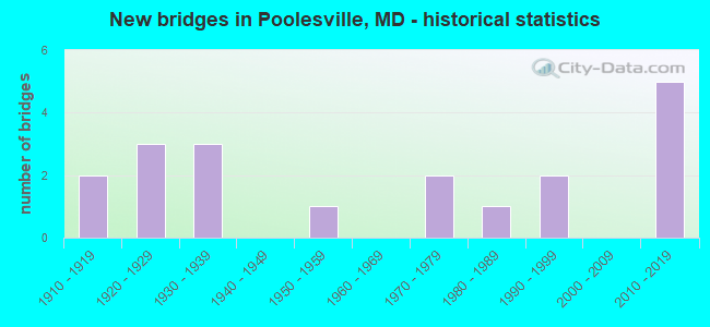
- New bridges - historical statistics
- 21910-1919
- 31920-1929
- 31930-1939
- 11950-1959
- 21970-1979
- 11980-1989
- 21990-1999
- 52010-2019

- Reconstructed bridges - Historical Statistics
- 11940-1949
- 01950-1959
- 01960-1969
- 21970-1979
- 11980-1989
- 11990-1999
- 12000-2009
- 12010-2019


- Bridge Condition - Deck
- 14.3%Very good
- 42.9%Good
- 21.4%Satisfactory
- 14.3%Fair
- 7.1%Poor

- Bridge Condition - Superstructure
- 26.7%Very good
- 20.0%Good
- 26.7%Satisfactory
- 26.7%Fair

- Bridge Condition - Substructure
- 20.0%Very good
- 20.0%Good
- 26.7%Satisfactory
- 26.7%Fair
- 6.7%Poor

- Bridge Condition - Channel
- 31.6%Good
- 36.8%Satisfactory
- 21.1%Fair
- 10.5%Poor

- Bridge Condition - Culverts
- 25.0%Good
- 75.0%Satisfactory
Find on map >> Show street view
Structure Number: 10000015001402, Location: 1.4 MILES WEST OF MD 28 (Lat: 39.124003, Lng: -77.368228), Route carried "on" structure: State highway 107, Year Built: 1992, Status: Open, Structure Length: 1.18m (3.87ft), Average Daily Traffic: 5,862 (year 2013), Truck Traffic: 7%, Average Future Daily Traffic: 7,622 (year 2026), Design Load: HS 25 or greater, Features Intersected: DRY SENECA CREEK
Minimum Vertical Clearance: 30+ m (98+ ft), Kilometerpoint: 5.466, Lanes on structure: 2, Owner: State Highway Agency, Approaching Roadway Width: 12.2m (40.0ft), Skew: 1 degrees, Material/Design: Concrete, Design/Construction: Culvert, Length of Maximum Span: 3.7m (12.1ft)
Condition: Channel: Satisfactory, Culverts: Satisfactory, Operating Rating: 32.7 metric tons, Method Used To Determine Operating Rating: Field evaluation and documented engineering judgment, Inventory Rating: 32.7 metric tons, Method Used To Determine Inventory Rating: Field evaluation and documented engineering judgment, Structural Evaluation: Equal to present minimum criteria, Waterway Adequacy: Superior to present desirable criteria, Approach Roadway Alignment: Equal to present desirable criteria, Designated Inspection Frequency: Every 24 months, Inspection Date: August 2020, Deck Structure Type: Concrete Cast-file-Place, Wearing Surface/Protective System: Wearing Surface: Bituminous
Find on map >> Show street view
Structure Number: 10000015006602, Location: 0.98 MILE WEST OF MD 117 (Lat: 39.157481, Lng: -77.376728), Route carried "on" structure: State highway 28, Year Built: 1954, Status: Open, Structure Length: 0.70m (2.30ft), Average Daily Traffic: 5,420 (year 2009), Truck Traffic: 8%, Average Future Daily Traffic: 6,492 (year 2026), Design Load: H 20, Features Intersected: BR OF DRY SENECA CREEK
Minimum Vertical Clearance: 30+ m (98+ ft), Kilometerpoint: 11.183, Lanes on structure: 2, Base Highway Network: Yes, Owner: State Highway Agency, Approaching Roadway Width: 6.1m (20.0ft), Skew: 3 degrees, Material/Design: Concrete, Design/Construction: Culvert, Length of Maximum Span: 6.1m (20.0ft)
Condition: Channel: Good, Culverts: Satisfactory, Operating Rating: 41.7 metric tons, Method Used To Determine Operating Rating: Allowable Stress (AS), Inventory Rating: 19.0 metric tons, Method Used To Determine Inventory Rating: Allowable Stress (AS), Structural Evaluation: Meets minimum limits, Waterway Adequacy: Better than present minimum criteria, Approach Roadway Alignment: Equal to present desirable criteria, Designated Inspection Frequency: Every 24 months, Inspection Date: August 2020
Find on map >> Show street view
Structure Number: 200000M-002801, Location: 1 MI N OF JCT SR 112 (Lat: 39.090647, Lng: -77.326719), Route carried "on" structure: County highway 264, Year Built: 1930, Year Reconstructed: 1996, Status: Posted for load, Structure Length: 1.01m (3.31ft), Average Daily Traffic: 710 (year 2011), Truck Traffic: 3%, Average Future Daily Traffic: 1,000 (year 2031), Design Load: HS 20, Features Intersected: SENECA CREEK TRIB, Facility Carried by Structure: BERRYVILLE RD
Minimum Vertical Clearance: 30+ m (98+ ft), Kilometerpoint: 4.280, Lanes on structure: 1, Owner: County Highway Agency, Approaching Roadway Width: 5.5m (18.0ft), Material/Design: Steel, Design/Construction: Stringer/Multi-beam, Number Of Spans In Main Unit: 1, Length of Maximum Span: 8.5m (27.9ft), Curb-To-Curb Width: 4.1m (13.5ft), Out-to-Out Width: 4.5m (14.8ft)
Condition: Deck: Fair, Superstructure: Fair, Substructure: Fair, Channel: Poor, Operating Rating: 66.2 metric tons, Method Used To Determine Operating Rating: Load Factor (LF), Inventory Rating: 39.9 metric tons, Method Used To Determine Inventory Rating: Load Factor (LF), Structural Evaluation: Somewhat better than minimum adequacy, Deck Geometry: High priority of replacement, Waterway Adequacy: Equal to present minimum criteria, Approach Roadway Alignment: High priority of corrective action, Length Of Structure Improvement: 1.52m (4.99ft), Designated Inspection Frequency: Every 24 months, Inspection Date: June 2020, Bridge Improvement Cost: $154,000, Roadway Improvement Cost: $15,000, Total Project Cost: $231,000, Deck Structure Type: Corrugated Steel, Wearing Surface/Protective System: Wearing Surface: Bituminous
Find on map >> Show street view
Structure Number: 200000M-003001, Location: 1.1 M N OF RIVER RD (Lat: 39.093653, Lng: -77.347161), Route carried "on" structure: County highway 266, Year Built: 1910, Year Reconstructed: 2018, Status: Posted for load, Structure Length: 1.61m (5.28ft), Average Daily Traffic: 150 (year 2019), Truck Traffic: 5%, Average Future Daily Traffic: 200 (year 2041), Design Load: HS 20, Features Intersected: DRY SENECA CREEK, Facility Carried by Structure: MONTEVIDEO ROAD
Minimum Vertical Clearance: 30+ m (98+ ft), Kilometerpoint: 1.673, Lanes on structure: 1, Owner: County Highway Agency, Approaching Roadway Width: 4.0m (13.1ft), Material/Design: Steel, Design/Construction: Truss - Thru, Number Of Spans In Main Unit: 1, Length of Maximum Span: 14.9m (48.9ft), Curb or Sidewalk Widths: Left: 0.2m (0.7ft), Right: 0.2m (0.7ft), Curb-To-Curb Width: 3.9m (12.8ft), Out-to-Out Width: 4.3m (14.1ft)
Condition: Deck: Very good, Superstructure: Good, Substructure: Good, Channel: Fair, Operating Rating: 60.8 metric tons, Method Used To Determine Operating Rating: Load Factor (LF), Inventory Rating: 36.3 metric tons, Method Used To Determine Inventory Rating: Load Factor (LF), Structural Evaluation: Better than present minimum criteria, Deck Geometry: High priority of replacement, Waterway Adequacy: Equal to present minimum criteria, Approach Roadway Alignment: High priority of corrective action, Designated Inspection Frequency: Every 24 months, Critical Feature Inspection Frequency: Every 24 months, Inspection Date: March 2021, Critical Feature Inspection Date: March 2021, Deck Structure Type: Concrete Cast-file-Place
Find on map >> Show street view
Structure Number: 200000M-003301, Location: 2.3 MI S OF JCT SR 28 (Lat: 39.105017, Lng: -77.365339), Route carried "on" structure: County highway 269, Year Built: 1971, Status: Open, Structure Length: 1.71m (5.61ft), Average Daily Traffic: 433 (year 2019), Truck Traffic: 5%, Average Future Daily Traffic: 528 (year 2039), Design Load: HS 20, Features Intersected: DRY SENECA CREEK, Facility Carried by Structure: SUGARLAND ROAD
Minimum Vertical Clearance: 30+ m (98+ ft), Kilometerpoint: 3.910, Lanes on structure: 2, Owner: County Highway Agency, Approaching Roadway Width: 11.0m (36.1ft), Material/Design: Steel, Design/Construction: Stringer/Multi-beam, Number Of Spans In Main Unit: 1, Length of Maximum Span: 15.9m (52.2ft), Curb-To-Curb Width: 11.0m (36.1ft), Out-to-Out Width: 11.9m (39.0ft)
Condition: Deck: Good, Superstructure: Good, Substructure: Satisfactory, Channel: Good, Inventory Rating: 58.0 metric tons, Method Used To Determine Inventory Rating: Load Factor (LF), Structural Evaluation: Equal to present minimum criteria, Deck Geometry: Better than present minimum criteria, Waterway Adequacy: Better than present minimum criteria, Approach Roadway Alignment: Equal to present minimum criteria, Designated Inspection Frequency: Every 24 months, Inspection Date: September 2020, Deck Structure Type: Concrete Cast-file-Place, Wearing Surface/Protective System: Wearing Surface: Monolithic Concrete
Find on map >> Show street view
Structure Number: 200000M-003701, Location: 1.2 MI S OF JCT SR 107 (Lat: 39.114036, Lng: -77.380572), Route carried "on" structure: County highway 1015, Year Built: 1920, Year Reconstructed: 1976, Status: Open, Structure Length: 0.79m (2.59ft), Average Daily Traffic: 2,174 (year 2019), Truck Traffic: 5%, Average Future Daily Traffic: 3,010 (year 2041), Design Load: HS 20, Features Intersected: RUSSELL BRANCH, Facility Carried by Structure: PARTNERSHIP RD
Minimum Vertical Clearance: 30+ m (98+ ft), Kilometerpoint: 4.553, Lanes on structure: 2, Base Highway Network: Yes, Owner: County Highway Agency, Approaching Roadway Width: 5.8m (19.0ft), Material/Design: Steel, Design/Construction: Stringer/Multi-beam, Number Of Spans In Main Unit: 1, Length of Maximum Span: 7.0m (23.0ft), Curb-To-Curb Width: 7.6m (24.9ft), Out-to-Out Width: 7.8m (25.6ft)
Condition: Deck: Satisfactory, Superstructure: Fair, Substructure: Satisfactory, Channel: Good, Operating Rating: 71.7 metric tons, Method Used To Determine Operating Rating: Load Factor (LF), Inventory Rating: 43.1 metric tons, Method Used To Determine Inventory Rating: Load Factor (LF), Structural Evaluation: Somewhat better than minimum adequacy, Deck Geometry: High priority of replacement, Waterway Adequacy: Equal to present minimum criteria, Approach Roadway Alignment: Equal to present minimum criteria, Length Of Structure Improvement: 1.16m (3.81ft), Designated Inspection Frequency: Every 24 months, Inspection Date: November 2020, Bridge Improvement Cost: $13,000, Total Project Cost: $13,000 ( Estimate for 2015), Deck Structure Type: Corrugated Steel, Wearing Surface/Protective System: Wearing Surface: Bituminous
Find on map >> Show street view
Structure Number: 200000M-004001, Location: 0.3 MI E OF ELMER SCHOOL (Lat: 39.118128, Lng: -77.480844), Route carried "on" structure: County highway 277, Year Built: 1911, Year Reconstructed: 1992, Status: Posted for load, Structure Length: 0.99m (3.25ft), Average Daily Traffic: 444 (year 2020), Truck Traffic: 3%, Average Future Daily Traffic: 577 (year 2040), Features Intersected: BROAD RUN, Facility Carried by Structure: RIVER ROAD
Minimum Vertical Clearance: 30+ m (98+ ft), Kilometerpoint: 1.754, Lanes on structure: 1, Owner: County Highway Agency, Approaching Roadway Width: 4.9m (16.1ft), Material/Design: Steel, Design/Construction: Stringer/Multi-beam, Number Of Spans In Main Unit: 1, Length of Maximum Span: 8.8m (28.9ft), Curb-To-Curb Width: 4.0m (13.1ft), Out-to-Out Width: 4.2m (13.8ft)
Condition: Deck: Good, Superstructure: Satisfactory, Substructure: Satisfactory, Channel: Satisfactory, Operating Rating: 42.6 metric tons, Method Used To Determine Operating Rating: Load Factor (LF), Inventory Rating: 25.4 metric tons, Method Used To Determine Inventory Rating: Load Factor (LF), Structural Evaluation: Equal to present minimum criteria, Deck Geometry: High priority of replacement, Waterway Adequacy: Equal to present minimum criteria, Approach Roadway Alignment: Equal to present minimum criteria, Bridge Posting: Required (Relationship of Operating Rating to Maximum Legal Load: 20.0 - 29.9% below), Length Of Structure Improvement: 1.52m (4.99ft), Designated Inspection Frequency: Every 24 months, Inspection Date: March 2021, Bridge Improvement Cost: $154,000, Roadway Improvement Cost: $15,000, Total Project Cost: $231,000, Deck Structure Type: Corrugated Steel, Wearing Surface/Protective System: Wearing Surface: Bituminous
Find on map >> Show street view
Structure Number: 200000M-004101, Location: 0.2 MI W OF EDWARDS FERRY (Lat: 39.134206, Lng: -77.452017), Route carried "on" structure: County highway 280, Year Built: 1930, Year Reconstructed: 1982, Status: Open, Structure Length: 0.88m (2.89ft), Average Daily Traffic: 443 (year 2020), Truck Traffic: 3%, Average Future Daily Traffic: 576 (year 2040), Design Load: HS 20, Features Intersected: BROAD RUN, Facility Carried by Structure: CLUB HOLLOW ROAD
Minimum Vertical Clearance: 30+ m (98+ ft), Kilometerpoint: 0.306, Lanes on structure: 2, Owner: County Highway Agency, Approaching Roadway Width: 6.1m (20.0ft), Material/Design: Steel, Design/Construction: Stringer/Multi-beam, Number Of Spans In Main Unit: 1, Length of Maximum Span: 7.9m (25.9ft), Curb-To-Curb Width: 6.6m (21.7ft), Out-to-Out Width: 7.0m (23.0ft)
Condition: Deck: Good, Superstructure: Satisfactory, Substructure: Satisfactory, Channel: Satisfactory, Operating Rating: 85.3 metric tons, Method Used To Determine Operating Rating: Load Factor (LF), Inventory Rating: 51.2 metric tons, Method Used To Determine Inventory Rating: Load Factor (LF), Structural Evaluation: Equal to present minimum criteria, Deck Geometry: High priority of corrective action, Waterway Adequacy: Better than present minimum criteria, Approach Roadway Alignment: Equal to present desirable criteria, Length Of Structure Improvement: 0.88m (2.89ft), Designated Inspection Frequency: Every 24 months, Inspection Date: June 2020, Bridge Improvement Cost: $30,000, Roadway Improvement Cost: $3,000, Total Project Cost: $33,000, Deck Structure Type: Corrugated Steel, Wearing Surface/Protective System: Wearing Surface: Bituminous
Find on map >> Show street view
Structure Number: 200000M-004201, Location: 1.2 MI N OF WHITES FERRY (Lat: 39.194011, Lng: -77.466103), Route carried "on" structure: County highway 253, Year Built: 1925, Year Reconstructed: 1953, Status: Open, Structure Length: 0.85m (2.79ft), Average Daily Traffic: 1,238 (year 2019), Truck Traffic: 3%, Average Future Daily Traffic: 1,553 (year 2041), Design Load: HS 20, Features Intersected: POTOMAC RIVER TRIBUTARY, Facility Carried by Structure: MARTINSBURG ROAD
Minimum Vertical Clearance: 30+ m (98+ ft), Kilometerpoint: 4.055, Lanes on structure: 2, Owner: County Highway Agency, Approaching Roadway Width: 8.5m (27.9ft), Material/Design: Steel, Design/Construction: Stringer/Multi-beam, Number Of Spans In Main Unit: 1, Length of Maximum Span: 7.6m (24.9ft), Curb-To-Curb Width: 8.7m (28.5ft), Out-to-Out Width: 9.1m (29.9ft)
Condition: Deck: Poor, Superstructure: Satisfactory, Substructure: Fair, Channel: Poor, Operating Rating: 38.1 metric tons, Method Used To Determine Operating Rating: Load Factor (LF), Inventory Rating: 22.7 metric tons, Method Used To Determine Inventory Rating: Load Factor (LF), Structural Evaluation: Somewhat better than minimum adequacy, Deck Geometry: Somewhat better than minimum adequacy, Waterway Adequacy: Somewhat better than minimum adequacy, Approach Roadway Alignment: Equal to present desirable criteria, Length Of Structure Improvement: 0.85m (2.79ft), Designated Inspection Frequency: Every 12 months, Inspection Date: Febuary 2021, Bridge Improvement Cost: $54,000, Roadway Improvement Cost: $11,000, Total Project Cost: $65,000 ( Estimate for 2015), Deck Structure Type: Corrugated Steel, Wearing Surface/Protective System: Wearing Surface: Bituminous
Find on map >> Show street view
Structure Number: 200000M-013701, Location: 0.5 MI E MD RTE 121 (Lat: 0.000108, Lng: -0.000214), Route carried "on" structure: County highway 261, Year Built: 1925, Status: Posted for load, Structure Length: 1.34m (4.40ft), Average Daily Traffic: 437 (year 2021), Truck Traffic: 5%, Average Future Daily Traffic: 568 (year 2041), Features Intersected: LITTLE SENECA CREEK, Facility Carried by Structure: SCHAEFFER ROAD
Minimum Vertical Clearance: 30+ m (98+ ft), Kilometerpoint: 0.644, Lanes on structure: 1, Owner: County Highway Agency, Approaching Roadway Width: 5.2m (17.1ft), Material/Design: Steel, Design/Construction: Stringer/Multi-beam, Number Of Spans In Main Unit: 1, Length of Maximum Span: 11.9m (39.0ft), Curb-To-Curb Width: 4.9m (16.1ft), Out-to-Out Width: 5.6m (18.4ft)
Condition: Deck: Fair, Superstructure: Fair, Substructure: Poor, Channel: Fair, Operating Rating: 49.0 metric tons, Method Used To Determine Operating Rating: Load Factor (LF), Inventory Rating: 29.5 metric tons, Method Used To Determine Inventory Rating: Load Factor (LF), Structural Evaluation: Meets minimum limits, Deck Geometry: High priority of replacement, Waterway Adequacy: Somewhat better than minimum adequacy, Approach Roadway Alignment: Equal to present minimum criteria, Bridge Posting: Required (Relationship of Operating Rating to Maximum Legal Load: 0.1 - 9.9% below), Length Of Structure Improvement: 1.49m (4.89ft), Designated Inspection Frequency: Every 24 months, Inspection Date: October 2021, Bridge Improvement Cost: $37,000, Roadway Improvement Cost: $4,000, Total Project Cost: $41,000, Deck Structure Type: Concrete Cast-file-Place, Wearing Surface/Protective System: Wearing Surface: Monolithic Concrete
Find on map >> Show street view
Structure Number: 200000M-013801, Location: 2 MILES NORTH OF MD 28 (Lat: 39.153336, Lng: -77.341450), Route carried "on" structure: County highway 259, Year Built: 2012, Status: Open, Structure Length: 1.59m (5.22ft), Average Daily Traffic: 770 (year 2017), Truck Traffic: 5%, Average Future Daily Traffic: 1,040 (year 2037), Design Load: HS 20, Features Intersected: BUCKLODGE BRANCH, Facility Carried by Structure: WHITE GROUND ROAD
Minimum Vertical Clearance: 30+ m (98+ ft), Kilometerpoint: 2.719, Lanes on structure: 1, Owner: County Highway Agency, Approaching Roadway Width: 4.9m (16.1ft), Skew: 2 degrees, Material/Design: Prestressed concrete, Design/Construction: Slab, Number Of Spans In Main Unit: 1, Length of Maximum Span: 14.6m (47.9ft), Curb-To-Curb Width: 4.9m (16.1ft), Out-to-Out Width: 6.1m (20.0ft)
Condition: Deck: Good, Superstructure: Good, Substructure: Good, Channel: Good, Operating Rating: 84.4 metric tons, Method Used To Determine Operating Rating: Load Factor (LF), Inventory Rating: 50.8 metric tons, Method Used To Determine Inventory Rating: Load Factor (LF), Structural Evaluation: Better than present minimum criteria, Deck Geometry: High priority of replacement, Waterway Adequacy: Equal to present desirable criteria, Approach Roadway Alignment: Equal to present minimum criteria, Designated Inspection Frequency: Every 24 months, Inspection Date: September 2020, Deck Structure Type: Concrete Precast Panels, Wearing Surface/Protective System: Wearing Surface: Monolithic Concrete, Deck Protection: Epoxy Coated Reinforcing
Find on map >> Show street view
Structure Number: 200000M-015501, Location: 1.5 MI S OF JCT SR 28 (Lat: 39.147419, Lng: -77.402342), Route carried "on" structure: County highway 257, Year Built: 1975, Year Reconstructed: 2009, Status: Open, Structure Length: 1.92m (6.30ft), Average Daily Traffic: 2,435 (year 2017), Truck Traffic: 3%, Average Future Daily Traffic: 3,165 (year 2037), Design Load: HS 20, Features Intersected: DRY SENECA CREEK, Facility Carried by Structure: CATTAIL ROAD
Minimum Vertical Clearance: 30+ m (98+ ft), Kilometerpoint: 2.446, Lanes on structure: 2, Owner: County Highway Agency, Approaching Roadway Width: 7.9m (25.9ft), Skew: 3 degrees, Material/Design: Steel, Design/Construction: Stringer/Multi-beam, Number Of Spans In Main Unit: 1, Length of Maximum Span: 17.7m (58.1ft), Curb-To-Curb Width: 9.8m (32.2ft), Out-to-Out Width: 10.1m (33.1ft)
Condition: Deck: Satisfactory, Superstructure: Fair, Substructure: Fair, Channel: Satisfactory, Inventory Rating: 57.6 metric tons, Method Used To Determine Inventory Rating: Load Factor (LF), Structural Evaluation: Somewhat better than minimum adequacy, Deck Geometry: Meets minimum limits, Waterway Adequacy: Equal to present minimum criteria, Approach Roadway Alignment: Equal to present desirable criteria, Designated Inspection Frequency: Every 24 months, Inspection Date: May 2020, Deck Structure Type: Corrugated Steel, Wearing Surface/Protective System: Wearing Surface: Bituminous
Find on map >> Show street view
Structure Number: 200000M-018102, Location: 1 MI N OF WESTERLY ROAD (Lat: 39.149492, Lng: -77.453900), Route carried "on" structure: County highway 254, Year Built: 1982, Status: Posted for load, Structure Length: 0.70m (2.30ft), Average Daily Traffic: 312 (year 2019), Truck Traffic: 5%, Average Future Daily Traffic: 427 (year 2041), Design Load: HS 20, Features Intersected: BROAD RUN, Facility Carried by Structure: EDWARDS FERRY ROAD
Minimum Vertical Clearance: 30+ m (98+ ft), Kilometerpoint: 2.623, Lanes on structure: 2, Owner: County Highway Agency, Approaching Roadway Width: 7.3m (24.0ft), Material/Design: Concrete, Design/Construction: Culvert, Length of Maximum Span: 3.4m (11.2ft), Curb-To-Curb Width: 7.3m (24.0ft), Out-to-Out Width: 7.9m (25.9ft)
Condition: Channel: Satisfactory, Culverts: Satisfactory, Operating Rating: 40.4 metric tons, Method Used To Determine Operating Rating: Load Factor (LF), Inventory Rating: 24.0 metric tons, Method Used To Determine Inventory Rating: Load Factor (LF), Structural Evaluation: Equal to present minimum criteria, Deck Geometry: Somewhat better than minimum adequacy, Waterway Adequacy: Equal to present minimum criteria, Approach Roadway Alignment: Equal to present minimum criteria, Length Of Structure Improvement: 0.73m (2.40ft), Designated Inspection Frequency: Every 24 months, Inspection Date: Febuary 2021, Bridge Improvement Cost: $7,000, Total Project Cost: $7,000
Find on map >> Show street view
Structure Number: 200000M-018601, Location: 3 MILES WEST OF MD 109 (Lat: 39.159089, Lng: -77.452781), Route carried "on" structure: County highway 281, Year Built: 1931, Status: Open, Structure Length: 1.23m (4.04ft), Average Daily Traffic: 1,988 (year 2021), Truck Traffic: 3%, Average Future Daily Traffic: 2,575 (year 2041), Features Intersected: BROAD RUN, Facility Carried by Structure: WHITES FERRY ROAD
Minimum Vertical Clearance: 30+ m (98+ ft), Kilometerpoint: 6.565, Lanes on structure: 2, Owner: County Highway Agency, Approaching Roadway Width: 6.1m (20.0ft), Skew: 3 degrees, Material/Design: Concrete, Design/Construction: Slab, Number Of Spans In Main Unit: 2, Length of Maximum Span: 4.9m (16.1ft), Curb-To-Curb Width: 8.2m (26.9ft), Out-to-Out Width: 9.3m (30.5ft)
Condition: Deck: Satisfactory, Superstructure: Satisfactory, Substructure: Fair, Channel: Satisfactory, Inventory Rating: 65.3 metric tons, Method Used To Determine Inventory Rating: Load Factor (LF), Structural Evaluation: Somewhat better than minimum adequacy, Deck Geometry: Meets minimum limits, Waterway Adequacy: Better than present minimum criteria, Approach Roadway Alignment: Equal to present desirable criteria, Length Of Structure Improvement: 1.52m (4.99ft), Designated Inspection Frequency: Every 24 months, Inspection Date: July 2021, Bridge Improvement Cost: $95,000, Roadway Improvement Cost: $10,000, Total Project Cost: $105,000, Deck Structure Type: Concrete Cast-file-Place, Wearing Surface/Protective System: Wearing Surface: Bituminous
Find on map >> Show street view
Structure Number: 200000M-018701, Location: 0.3 MI E OF WASCHE ROAD (Lat: 39.156533, Lng: -77.447189), Route carried "on" structure: County highway 281, Year Built: 2014, Status: Open, Structure Length: 1.40m (4.59ft), Average Daily Traffic: 1,907 (year 2021), Truck Traffic: 5%, Average Future Daily Traffic: 2,479 (year 2041), Design Load: HS 25 or greater, Features Intersected: BROAD RUN TRIBUTARY, Facility Carried by Structure: WHITES FERRY ROAD
Minimum Vertical Clearance: 30+ m (98+ ft), Kilometerpoint: 0.000, Lanes on structure: 2, Owner: County Highway Agency, Approaching Roadway Width: 9.1m (29.9ft), Skew: 3 degrees, Material/Design: Prestressed concrete, Design/Construction: Slab, Number Of Spans In Main Unit: 1, Length of Maximum Span: 14.0m (45.9ft), Curb-To-Curb Width: 9.1m (29.9ft), Out-to-Out Width: 10.1m (33.1ft)
Condition: Deck: Very good, Superstructure: Very good, Substructure: Very good, Channel: Good, Operating Rating: 69.4 metric tons, Method Used To Determine Operating Rating: Load Factor (LF), Inventory Rating: 41.3 metric tons, Method Used To Determine Inventory Rating: Load Factor (LF), Structural Evaluation: Equal to present desirable criteria, Deck Geometry: Somewhat better than minimum adequacy, Waterway Adequacy: Better than present minimum criteria, Approach Roadway Alignment: Equal to present desirable criteria, Designated Inspection Frequency: Every 24 months, Inspection Date: July 2021, Deck Structure Type: Concrete Precast Panels, Wearing Surface/Protective System: Wearing Surface: Integral Concrete, Deck Protection: Epoxy Coated Reinforcing
Find on map >> Show street view
Structure Number: 200000M-018801, Location: 2 MI W OF JCT SR 109 (Lat: 39.152483, Lng: -77.439169), Route carried "on" structure: County highway 281, Year Built: 1998, Status: Open, Structure Length: 1.49m (4.89ft), Average Daily Traffic: 1,999 (year 2019), Truck Traffic: 5%, Average Future Daily Traffic: 2,599 (year 2039), Design Load: HS 25 or greater, Features Intersected: BROAD RUN TRIBUTARY, Facility Carried by Structure: WHITES FERRY ROAD
Minimum Vertical Clearance: 30+ m (98+ ft), Kilometerpoint: 7.965, Lanes on structure: 2, Owner: County Highway Agency, Approaching Roadway Width: 9.1m (29.9ft), Material/Design: Prestressed concrete, Design/Construction: Slab, Number Of Spans In Main Unit: 1, Length of Maximum Span: 14.0m (45.9ft), Curb-To-Curb Width: 9.2m (30.2ft), Out-to-Out Width: 10.2m (33.5ft)
Condition: Deck: Good, Superstructure: Very good, Substructure: Good, Channel: Satisfactory, Inventory Rating: 57.1 metric tons, Method Used To Determine Inventory Rating: Load Factor (LF), Structural Evaluation: Better than present minimum criteria, Deck Geometry: Somewhat better than minimum adequacy, Waterway Adequacy: High priority of corrective action, Approach Roadway Alignment: Equal to present desirable criteria, Length Of Structure Improvement: 1.49m (4.89ft), Designated Inspection Frequency: Every 24 months, Inspection Date: May 2020, Bridge Improvement Cost: $7,000, Roadway Improvement Cost: $1,000, Total Project Cost: $8,000, Deck Structure Type: Concrete Cast-file-Place, Wearing Surface/Protective System: Wearing Surface: Integral Concrete, Deck Protection: Epoxy Coated Reinforcing
Find on map >> Show street view
Structure Number: 200000M-018901, Location: 1 MI W OF ELGIN ROAD (Lat: 39.147781, Lng: -77.432869), Route carried "on" structure: County highway 281, Year Built: 2014, Status: Open, Structure Length: 0.73m (2.40ft), Average Daily Traffic: 1,836 (year 2021), Truck Traffic: 5%, Average Future Daily Traffic: 2,387 (year 2041), Design Load: HS 25 or greater, Features Intersected: BROAD RUN TRIBUTARY, Facility Carried by Structure: WHITES FERRY ROAD
Minimum Vertical Clearance: 30+ m (98+ ft), Kilometerpoint: 8.737, Lanes on structure: 2, Owner: County Highway Agency, Approaching Roadway Width: 9.1m (29.9ft), Material/Design: Prestressed concrete, Design/Construction: Slab, Number Of Spans In Main Unit: 1, Length of Maximum Span: 7.3m (24.0ft), Curb-To-Curb Width: 9.1m (29.9ft), Out-to-Out Width: 10.1m (33.1ft)
Condition: Deck: Good, Superstructure: Very good, Substructure: Very good, Channel: Good, Inventory Rating: 65.3 metric tons, Method Used To Determine Inventory Rating: Load Factor (LF), Structural Evaluation: Equal to present desirable criteria, Deck Geometry: Somewhat better than minimum adequacy, Waterway Adequacy: Better than present minimum criteria, Approach Roadway Alignment: Equal to present desirable criteria, Designated Inspection Frequency: Every 24 months, Inspection Date: July 2021, Deck Structure Type: Concrete Precast Panels, Wearing Surface/Protective System: Wearing Surface: Integral Concrete, Deck Protection: Epoxy Coated Reinforcing
Find on map >> Show street view
Structure Number: 200000M-032602, Location: 0.37 MILES EAST OF MD 109 (Lat: 39.155389, Lng: -77.411333), Route carried "on" structure: County highway 256, Year Built: 2013, Status: Open, Structure Length: 0.83m (2.72ft), Average Daily Traffic: 1,036 (year 2021), Truck Traffic: 5%, Average Future Daily Traffic: 1,117 (year 2041), Features Intersected: DRY SENECA CREEK, Facility Carried by Structure: JERUSALEM ROAD
Minimum Vertical Clearance: 30+ m (98+ ft), Kilometerpoint: 0.000, Lanes on structure: 2, Owner: County Highway Agency, Approaching Roadway Width: 7.3m (24.0ft), Material/Design: Concrete, Design/Construction: Culvert, Length of Maximum Span: 2.4m (7.9ft), Curb-To-Curb Width: 7.7m (25.3ft), Out-to-Out Width: 8.6m (28.2ft)
Condition: Channel: Fair, Culverts: Good, Operating Rating: 43.7 metric tons, Method Used To Determine Operating Rating: Load and Resistance Factor Rating (LRFR) rating reported by rating factor(RF) method using HL-93 loadings, Inventory Rating: 34.0 metric tons, Method Used To Determine Inventory Rating: Load and Resistance Factor Rating (LRFR) rating reported by rating factor(RF) method using HL-93 loadings, Structural Evaluation: Better than present minimum criteria, Deck Geometry: Meets minimum limits, Waterway Adequacy: Better than present minimum criteria, Approach Roadway Alignment: Equal to present desirable criteria, Designated Inspection Frequency: Every 24 months, Inspection Date: Febuary 2021
Find on map >> Show street view
Structure Number: 200000M-PK2501, Location: 0.18 MI WEST OF MD RTE 28 (Lat: 39.192528, Lng: -77.428361), Route carried "on" structure: Other road , Year Built: 2010, Status: Open, Structure Length: 0.73m (2.40ft), Average Daily Traffic: 20 (year 2019), Average Future Daily Traffic: 36 (year 2041), Design Load: HS 25 or greater, Features Intersected: TRIB TO LITTLE MONOCACY, Facility Carried by Structure: JEB STUART TRAIL
Minimum Vertical Clearance: 30+ m (98+ ft), Kilometerpoint: 0.000, Lanes on structure: 1, Owner: Local Park, Forest, or Reservation Agency, Maintenance Responsibility: County Highway Agency, Approaching Roadway Width: 4.0m (13.1ft), Material/Design: Concrete, Design/Construction: Arch - Deck, Number Of Spans In Main Unit: 1, Length of Maximum Span: 7.3m (24.0ft), Curb-To-Curb Width: 6.4m (21.0ft), Out-to-Out Width: 7.3m (24.0ft)
Condition: Superstructure: Very good, Substructure: Very good, Channel: Fair, Inventory Rating: 54.9 metric tons, Method Used To Determine Inventory Rating: Load Factor (LF), Structural Evaluation: Equal to present desirable criteria, Deck Geometry: Somewhat better than minimum adequacy, Waterway Adequacy: Equal to present minimum criteria, Approach Roadway Alignment: Equal to present desirable criteria, Length Of Structure Improvement: 0.79m (2.59ft), Designated Inspection Frequency: Every 24 months, Inspection Date: November 2020, Bridge Improvement Cost: $1,000, Total Project Cost: $1,000 ( Estimate for 2015)