Bridge Statistics for Pomfret, Connecticut (CT)
Condition, Traffic, Stress, Structural Evaluation, Project Costs
- National Bridge Inventory (NBI) Statistics
- 16Number of bridges
- 121ft / 37.3mTotal length
- 201,161Total average daily traffic
- 21,489Total average daily truck traffic
- 298,906Total future (year 2036) average daily traffic
- National Bridge Inventory (NBI) Registered Bridges for Pomfret
- No street view available for this location
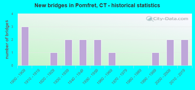
- New bridges - historical statistics
- 31900-1909
- 11920-1929
- 21930-1939
- 21940-1949
- 21950-1959
- 11960-1969
- 11990-1999
- 22000-2009
- 22010-2019

- Reconstructed bridges - Historical Statistics
- 31980-1989
- 01990-1999
- 52000-2009


- Bridge Condition - Deck
- 14.3%Very good
- 71.4%Good
- 14.3%Satisfactory

- Bridge Condition - Superstructure
- 13.3%Very good
- 60.0%Good
- 20.0%Satisfactory
- 6.7%Fair

- Bridge Condition - Substructure
- 13.3%Very good
- 26.7%Good
- 40.0%Satisfactory
- 6.7%Fair
- 6.7%Poor
- 6.7%Serious

- Bridge Condition - Channel
- 13.3%Very good
- 20.0%Good
- 40.0%Satisfactory
- 13.3%Fair
- 6.7%Poor
- 6.7%Serious
Find on map >> Show street view
Structure Number: 99, Location: BETWEEN EXITS 24 & 25 (Lat: 41.167258, Lng: -73.219728), Route carried "on" structure: Interstate 95, Year Built: 2006, Status: Open, Structure Length: 15.12m (49.61ft), Average Daily Traffic: 130,700 (year 2017), Truck Traffic: 14%, Average Future Daily Traffic: 194,207 (year 2037), Design Load: HS 20, Features Intersected: METRO-NORTH RAILROAD
Minimum Vertical Clearance: 30+ m (98+ ft), Kilometerpoint: 44.257, Lanes on structure: 7, Base Highway Network: Yes, Owner: State Highway Agency, Approaching Roadway Width: 46.9m (153.9ft), Skew: 36 degrees, Material/Design: Steel continuous, Design/Construction: Stringer/Multi-beam, Number Of Spans In Main Unit: 3, Length of Maximum Span: 70.7m (232.0ft), Curb-To-Curb Width: 47.0m (154.2ft), Out-to-Out Width: 50.0m (164.0ft)
Condition: Deck: Good, Superstructure: Good, Substructure: Satisfactory, Inventory Rating: 76.4 metric tons, Method Used To Determine Inventory Rating: Load Factor (LF), Structural Evaluation: Equal to present minimum criteria, Deck Geometry: Superior to present desirable criteria, Underclear: Better than present minimum criteria, Approach Roadway Alignment: Equal to present desirable criteria, Designated Inspection Frequency: Every 24 months, Inspection Date: January 2021, Deck Structure Type: Concrete Cast-file-Place, Wearing Surface/Protective System: Wearing Surface: Bituminous, Membrane: Built-up, Deck Protection: Epoxy Coated Reinforcing
Find on map >> Show street view
Structure Number: 535, Location: 100 FT S OF ROUTE 102 (Lat: 41.267294, Lng: -73.441592), Route carried "on" structure: US 7, Year Built: 1961, Status: Open, Structure Length: 1.07m (3.51ft), Average Daily Traffic: 21,500 (year 2017), Truck Traffic: 6%, Average Future Daily Traffic: 31,947 (year 2037), Design Load: HS 20, Features Intersected: COOPER POND BROOK
Minimum Vertical Clearance: 30+ m (98+ ft), Kilometerpoint: 20.181, Lanes on structure: 3, Base Highway Network: Yes, Owner: State Highway Agency, Approaching Roadway Width: 12.2m (40.0ft), Skew: 4 degrees, Material/Design: Concrete continuous, Design/Construction: Culvert, Number Of Spans In Main Unit: 2, Length of Maximum Span: 5.2m (17.1ft), Curb-To-Curb Width: 12.2m (40.0ft), Out-to-Out Width: 13.9m (45.6ft)
Condition: Channel: Fair, Culverts: Satisfactory, Operating Rating: 45.4 metric tons, Method Used To Determine Operating Rating: Load and Resistance Factor Rating (LRFR) rating reported by rating factor(RF) method using HL-93 loadings, Inventory Rating: 35.0 metric tons, Method Used To Determine Inventory Rating: Load and Resistance Factor Rating (LRFR) rating reported by rating factor(RF) method using HL-93 loadings, Structural Evaluation: Equal to present minimum criteria, Deck Geometry: Meets minimum limits, Waterway Adequacy: Superior to present desirable criteria, Approach Roadway Alignment: Equal to present desirable criteria, Designated Inspection Frequency: Every 24 months, Inspection Date: June 2021, Deck Structure Type: Other, Wearing Surface/Protective System: Wearing Surface: Bituminous
Find on map >> Show street view
Structure Number: 987, Location: 0.4 MILE EAST OF ROUTE 97 (Lat: 41.859308, Lng: -71.999725), Route carried "on" structure: US 44, Year Built: 1942, Year Reconstructed: 2011, Status: Open, Structure Length: 1.99m (6.53ft), Average Daily Traffic: 6,500 (year 2016), Truck Traffic: 4%, Average Future Daily Traffic: 9,658 (year 2036), Design Load: HS 20, Features Intersected: ABINGTON BROOK
Minimum Vertical Clearance: 30+ m (98+ ft), Kilometerpoint: 147.818, Lanes on structure: 2, Base Highway Network: Yes, Owner: State Highway Agency, Approaching Roadway Width: 10.4m (34.1ft), Material/Design: Steel, Design/Construction: Stringer/Multi-beam, Number Of Spans In Main Unit: 1, Length of Maximum Span: 18.0m (59.1ft), Curb or Sidewalk Widths: Left: 1.5m (4.9ft), Right: 0.0m, Curb-To-Curb Width: 10.4m (34.1ft), Out-to-Out Width: 12.8m (42.0ft)
Condition: Deck: Good, Superstructure: Good, Substructure: Good, Channel: Good, Operating Rating: 58.8 metric tons, Method Used To Determine Operating Rating: Load Factor (LF), Inventory Rating: 35.2 metric tons, Method Used To Determine Inventory Rating: Load Factor (LF), Structural Evaluation: Better than present minimum criteria, Deck Geometry: Meets minimum limits, Waterway Adequacy: Equal to present desirable criteria, Approach Roadway Alignment: Equal to present desirable criteria, Designated Inspection Frequency: Every 24 months, Inspection Date: May 2021, Deck Structure Type: Concrete Cast-file-Place, Wearing Surface/Protective System: Wearing Surface: Bituminous, Membrane: Preformed Fabric
Find on map >> Show street view
Structure Number: 988, Location: 0.9 MI WEST OF ROUTE 101 (Lat: 41.861042, Lng: -71.983567), Route carried "on" structure: US 44, Year Built: 1941, Year Reconstructed: 2007, Status: Open, Structure Length: 1.21m (3.97ft), Average Daily Traffic: 6,500 (year 2016), Truck Traffic: 4%, Average Future Daily Traffic: 9,658 (year 2036), Design Load: HL 93, Features Intersected: MASHAMOQUET BROOK
Minimum Vertical Clearance: 30+ m (98+ ft), Kilometerpoint: 149.186, Lanes on structure: 2, Base Highway Network: Yes, Owner: State Highway Agency, Approaching Roadway Width: 9.8m (32.2ft), Skew: 1 degrees, Material/Design: Steel, Design/Construction: Stringer/Multi-beam, Number Of Spans In Main Unit: 1, Length of Maximum Span: 10.9m (35.8ft), Curb-To-Curb Width: 9.8m (32.2ft), Out-to-Out Width: 10.9m (35.8ft)
Condition: Deck: Good, Superstructure: Good, Substructure: Satisfactory, Channel: Satisfactory, Structural Evaluation: Equal to present minimum criteria, Deck Geometry: Meets minimum limits, Waterway Adequacy: Superior to present desirable criteria, Approach Roadway Alignment: Equal to present desirable criteria, Designated Inspection Frequency: Every 24 months, Inspection Date: May 2021, Deck Structure Type: Concrete Cast-file-Place, Wearing Surface/Protective System: Wearing Surface: Bituminous, Membrane: Built-up, Deck Protection: Epoxy Coated Reinforcing
Find on map >> Show street view
Structure Number: 99, Location: 0.14 MILE NORTH OF SR 644 (Lat: 41.872225, Lng: -71.962403), Route carried "on" structure: US 44, Year Built: 2016, Status: Open, Structure Length: 1.03m (3.38ft), Average Daily Traffic: 3,800 (year 2016), Truck Traffic: 4%, Average Future Daily Traffic: 5,646 (year 2036), Design Load: HL 93, Features Intersected: WAPPOQUIA BROOK
Minimum Vertical Clearance: 30+ m (98+ ft), Kilometerpoint: 152.115, Lanes on structure: 2, Base Highway Network: Yes, Owner: State Highway Agency, Approaching Roadway Width: 10.6m (34.8ft), Skew: 4 degrees, Material/Design: Concrete, Design/Construction: Frame, Number Of Spans In Main Unit: 1, Length of Maximum Span: 9.0m (29.5ft), Curb-To-Curb Width: 10.6m (34.8ft), Out-to-Out Width: 11.6m (38.1ft)
Condition: Superstructure: Good, Substructure: Very good, Channel: Very good, Operating Rating: 74.2 metric tons, Method Used To Determine Operating Rating: Load and Resistance Factor Rating (LRFR) rating reported by rating factor(RF) method using HL-93 loadings, Inventory Rating: 57.0 metric tons, Method Used To Determine Inventory Rating: Load and Resistance Factor Rating (LRFR) rating reported by rating factor(RF) method using HL-93 loadings, Structural Evaluation: Better than present minimum criteria, Deck Geometry: Somewhat better than minimum adequacy, Waterway Adequacy: Equal to present desirable criteria, Approach Roadway Alignment: Equal to present desirable criteria, Designated Inspection Frequency: Every 24 months, Inspection Date: August 2021, Deck Structure Type: Concrete Precast Panels, Wearing Surface/Protective System: Wearing Surface: Bituminous, Membrane: Built-up, Deck Protection: Epoxy Coated Reinforcing
Find on map >> Show street view
Structure Number: 1295, Location: .3 MI WEST OF RTE 169 (Lat: 41.860022, Lng: -71.962708), Route carried "on" structure: State highway 101, Year Built: 1929, Year Reconstructed: 1986, Status: Open, Structure Length: 1.16m (3.81ft), Average Daily Traffic: 8,300 (year 2016), Truck Traffic: 4%, Average Future Daily Traffic: 12,333 (year 2036), Design Load: H 15, Features Intersected: MASHAMOQUET BROOK
Minimum Vertical Clearance: 30+ m (98+ ft), Kilometerpoint: 0.290, Lanes on structure: 2, Base Highway Network: Yes, Owner: State Highway Agency, Approaching Roadway Width: 8.8m (28.9ft), Skew: 1 degrees, Material/Design: Concrete, Design/Construction: Tee Beam, Number Of Spans In Main Unit: 1, Length of Maximum Span: 10.4m (34.1ft), Curb-To-Curb Width: 8.5m (27.9ft), Out-to-Out Width: 9.4m (30.8ft)
Condition: Deck: Satisfactory, Superstructure: Satisfactory, Substructure: Satisfactory, Channel: Satisfactory, Operating Rating: 36.9 metric tons, Method Used To Determine Operating Rating: Load and Resistance Factor Rating (LRFR) rating reported by rating factor(RF) method using HL-93 loadings, Inventory Rating: 28.5 metric tons, Method Used To Determine Inventory Rating: Load and Resistance Factor Rating (LRFR) rating reported by rating factor(RF) method using HL-93 loadings, Structural Evaluation: Equal to present minimum criteria, Deck Geometry: High priority of replacement, Waterway Adequacy: Equal to present desirable criteria, Approach Roadway Alignment: Equal to present desirable criteria, Designated Inspection Frequency: Every 24 months, Inspection Date: November 2020, Deck Structure Type: Concrete Cast-file-Place, Wearing Surface/Protective System: Wearing Surface: Bituminous, Membrane: Preformed Fabric
Find on map >> Show street view
Structure Number: 1296, Location: 1.7 MILES EAST OF RTE 169 (Lat: 41.847931, Lng: -71.930047), Route carried "on" structure: State highway 101, Year Built: 1932, Status: Open, Structure Length: 0.76m (2.49ft), Average Daily Traffic: 8,400 (year 2019), Truck Traffic: 4%, Average Future Daily Traffic: 12,482 (year 2039), Design Load: H 20, Features Intersected: WHITE BROOK
Minimum Vertical Clearance: 30+ m (98+ ft), Kilometerpoint: 3.412, Lanes on structure: 2, Base Highway Network: Yes, Owner: State Highway Agency, Approaching Roadway Width: 8.8m (28.9ft), Skew: 1 degrees, Material/Design: Concrete, Design/Construction: Slab, Number Of Spans In Main Unit: 1, Length of Maximum Span: 6.1m (20.0ft), Curb-To-Curb Width: 9.1m (29.9ft), Out-to-Out Width: 10.7m (35.1ft)
Condition: Deck: Satisfactory, Superstructure: Fair, Substructure: Satisfactory, Channel: Satisfactory, Operating Rating: 63.9 metric tons, Method Used To Determine Operating Rating: Load Factor (LF), Inventory Rating: 38.4 metric tons, Method Used To Determine Inventory Rating: Load Factor (LF), Structural Evaluation: Somewhat better than minimum adequacy, Deck Geometry: High priority of corrective action, Waterway Adequacy: Equal to present desirable criteria, Approach Roadway Alignment: Equal to present desirable criteria, Designated Inspection Frequency: Every 24 months, Inspection Date: November 2021, Deck Structure Type: Concrete Cast-file-Place, Wearing Surface/Protective System: Wearing Surface: Bituminous, Membrane: Built-up
Find on map >> Show street view
Structure Number: 1297, Location: AT KILLINGLY TOWN LINE (Lat: 41.849289, Lng: -71.921086), Route carried "on" structure: State highway 101, Year Built: 1957, Year Reconstructed: 1989, Status: Open, Structure Length: 4.72m (15.49ft), Average Daily Traffic: 9,100 (year 2016), Truck Traffic: 4%, Average Future Daily Traffic: 13,522 (year 2036), Design Load: HS 20, Features Intersected: QUINEBAUG RIVER
Minimum Vertical Clearance: 30+ m (98+ ft), Kilometerpoint: 4.152, Lanes on structure: 2, Base Highway Network: Yes, Owner: State Highway Agency, Approaching Roadway Width: 9.2m (30.2ft), Material/Design: Steel, Design/Construction: Stringer/Multi-beam, Number Of Spans In Main Unit: 2, Length of Maximum Span: 22.6m (74.1ft), Curb-To-Curb Width: 9.2m (30.2ft), Out-to-Out Width: 10.4m (34.1ft)
Condition: Deck: Good, Superstructure: Satisfactory, Substructure: Fair, Channel: Fair, Operating Rating: 74.2 metric tons, Method Used To Determine Operating Rating: Load and Resistance Factor Rating (LRFR) rating reported by rating factor(RF) method using HL-93 loadings, Inventory Rating: 57.3 metric tons, Method Used To Determine Inventory Rating: Load and Resistance Factor Rating (LRFR) rating reported by rating factor(RF) method using HL-93 loadings, Structural Evaluation: Somewhat better than minimum adequacy, Deck Geometry: High priority of corrective action, Waterway Adequacy: Equal to present desirable criteria, Approach Roadway Alignment: Equal to present desirable criteria, Designated Inspection Frequency: Every 24 months, Inspection Date: May 2021, Deck Structure Type: Concrete Cast-file-Place, Wearing Surface/Protective System: Wearing Surface: Bituminous, Membrane: Preformed Fabric, Deck Protection: Epoxy Coated Reinforcing
Find on map >> Show street view
Structure Number: 2594, Location: 1 MILE NORTH OF ROUTE 44 (Lat: 41.873883, Lng: -71.998431), Route carried "on" structure: State highway 97, Year Built: 2012, Status: Open, Structure Length: 1.83m (6.00ft), Average Daily Traffic: 1,500 (year 2016), Truck Traffic: 3%, Average Future Daily Traffic: 2,229 (year 2036), Design Load: HS 20, Features Intersected: MASHAMOQUET BROOK
Minimum Vertical Clearance: 30+ m (98+ ft), Kilometerpoint: 41.505, Lanes on structure: 2, Owner: State Highway Agency, Approaching Roadway Width: 9.8m (32.2ft), Skew: 2 degrees, Material/Design: Steel, Design/Construction: Stringer/Multi-beam, Number Of Spans In Main Unit: 1, Length of Maximum Span: 16.2m (53.1ft), Curb-To-Curb Width: 9.8m (32.2ft), Out-to-Out Width: 10.9m (35.8ft)
Condition: Deck: Very good, Superstructure: Very good, Substructure: Very good, Channel: Very good, Operating Rating: 93.4 metric tons, Method Used To Determine Operating Rating: Load Factor (LF), Inventory Rating: 56.1 metric tons, Method Used To Determine Inventory Rating: Load Factor (LF), Structural Evaluation: Equal to present desirable criteria, Deck Geometry: Somewhat better than minimum adequacy, Waterway Adequacy: Superior to present desirable criteria, Approach Roadway Alignment: Equal to present desirable criteria, Designated Inspection Frequency: Every 24 months, Inspection Date: April 2021, Deck Structure Type: Concrete Cast-file-Place, Wearing Surface/Protective System: Wearing Surface: Bituminous, Membrane: Built-up, Deck Protection: Epoxy Coated Reinforcing
Find on map >> Show street view
Structure Number: 5344, Location: .5 MI SOUTH OF ROUTE 101 (Lat: 41.856394, Lng: -71.966783), Route carried "on" structure: City street , Year Built: 1900, Year Reconstructed: 2009, Status: Open, Structure Length: 1.52m (4.99ft), Average Daily Traffic: 113 (year 2019), Truck Traffic: 1%, Average Future Daily Traffic: 168 (year 2039), Design Load: HS 20, Features Intersected: MASHAMOQUET BROOK, Facility Carried by Structure: WOLF DEN DRIVE
Minimum Vertical Clearance: 30+ m (98+ ft), Kilometerpoint: 0.241, Lanes on structure: 2, Owner: Town or Township Highway Agency, Approaching Roadway Width: 4.9m (16.1ft), Material/Design: Steel, Design/Construction: Stringer/Multi-beam, Number Of Spans In Main Unit: 1, Length of Maximum Span: 14.0m (45.9ft), Curb or Sidewalk Widths: Left: 0.2m (0.7ft), Right: 0.2m (0.7ft), Curb-To-Curb Width: 6.1m (20.0ft), Out-to-Out Width: 6.3m (20.7ft)
Condition: Deck: Very good, Superstructure: Good, Substructure: Satisfactory, Channel: Satisfactory, Operating Rating: 65.2 metric tons, Method Used To Determine Operating Rating: Load Factor (LF), Inventory Rating: 39.1 metric tons, Method Used To Determine Inventory Rating: Load Factor (LF), Structural Evaluation: Equal to present minimum criteria, Deck Geometry: Meets minimum limits, Waterway Adequacy: Better than present minimum criteria, Approach Roadway Alignment: Equal to present desirable criteria, Designated Inspection Frequency: Every 24 months, Inspection Date: December 2021, Deck Structure Type: Corrugated Steel, Wearing Surface/Protective System: Wearing Surface: Bituminous
Find on map >> Show street view
Structure Number: 535, Location: 800' NORTH OF ROUTE 101 (Lat: 41.857758, Lng: -71.954675), Route carried "on" structure: City street , Year Built: 1950, Year Reconstructed: 2000, Status: Open, Structure Length: 0.94m (3.08ft), Average Daily Traffic: 18 (year 2022), Truck Traffic: 1%, Average Future Daily Traffic: 27 (year 2042), Design Load: HS 20, Features Intersected: MASHAMOQUET BROOK, Facility Carried by Structure: BOSWORTH ROAD
Minimum Vertical Clearance: 30+ m (98+ ft), Kilometerpoint: 59.868, Lanes on structure: 2, Owner: Town or Township Highway Agency, Approaching Roadway Width: 4.6m (15.1ft), Material/Design: Steel, Design/Construction: Stringer/Multi-beam, Number Of Spans In Main Unit: 1, Length of Maximum Span: 8.2m (26.9ft), Curb-To-Curb Width: 5.5m (18.0ft), Out-to-Out Width: 5.5m (18.0ft)
Condition: Deck: Good, Superstructure: Good, Substructure: Poor, Channel: Poor, Operating Rating: 68.2 metric tons, Method Used To Determine Operating Rating: Load Factor (LF), Inventory Rating: 40.9 metric tons, Method Used To Determine Inventory Rating: Load Factor (LF), Structural Evaluation: Meets minimum limits, Deck Geometry: Meets minimum limits, Waterway Adequacy: Better than present minimum criteria, Approach Roadway Alignment: Equal to present desirable criteria, Designated Inspection Frequency: Every 24 months, Underwater Inspection Frequency: Every 24 months, Inspection Date: December 2021, Underwater Inspection Date: January 2022, Deck Structure Type: Corrugated Steel, Wearing Surface/Protective System: Wearing Surface: Bituminous, Membrane: Preformed Fabric
Find on map >> Show street view
Structure Number: 5351, Location: .2 MI NORTH OF ROUTE 101 (Lat: 41.850058, Lng: -71.935953), Route carried "on" structure: City street , Year Built: 1999, Status: Open, Structure Length: 1.64m (5.38ft), Average Daily Traffic: 630 (year 2021), Truck Traffic: 2%, Average Future Daily Traffic: 936 (year 2041), Design Load: HS 20, Features Intersected: MASHAMOQUET BROOK, Facility Carried by Structure: WRIGHTS CROSSING R
Minimum Vertical Clearance: 30+ m (98+ ft), Kilometerpoint: 0.000, Lanes on structure: 2, Owner: Town or Township Highway Agency, Approaching Roadway Width: 8.5m (27.9ft), Material/Design: Prestressed concrete, Design/Construction: Slab, Number Of Spans In Main Unit: 1, Length of Maximum Span: 15.1m (49.5ft), Curb-To-Curb Width: 8.7m (28.5ft), Out-to-Out Width: 9.9m (32.5ft)
Condition: Deck: Good, Superstructure: Good, Substructure: Good, Channel: Good, Operating Rating: 44.7 metric tons, Method Used To Determine Operating Rating: Load and Resistance Factor Rating (LRFR) rating reported by rating factor(RF) method using HL-93 loadings, Inventory Rating: 34.7 metric tons, Method Used To Determine Inventory Rating: Load and Resistance Factor Rating (LRFR) rating reported by rating factor(RF) method using HL-93 loadings, Structural Evaluation: Better than present minimum criteria, Deck Geometry: Somewhat better than minimum adequacy, Waterway Adequacy: Equal to present desirable criteria, Approach Roadway Alignment: Better than present minimum criteria, Designated Inspection Frequency: Every 24 months, Inspection Date: December 2021, Deck Structure Type: Other, Wearing Surface/Protective System: Wearing Surface: Bituminous, Membrane: Preformed Fabric, Deck Protection: Other
Find on map >> Show street view
Structure Number: 5422, Location: 0.2 MILE NORTH OF RTE 101 (Lat: 41.860964, Lng: -71.959222), Route carried "on" structure: State highway 169, Year Built: 1936, Year Reconstructed: 1985, Status: Open, Structure Length: 1.19m (3.90ft), Average Daily Traffic: 3,500 (year 2016), Truck Traffic: 3%, Average Future Daily Traffic: 5,201 (year 2036), Design Load: HS 20, Features Intersected: MASHAMOQUET BROOK
Minimum Vertical Clearance: 30+ m (98+ ft), Kilometerpoint: 41.376, Lanes on structure: 2, Owner: State Highway Agency, Approaching Roadway Width: 8.5m (27.9ft), Material/Design: Prestressed concrete, Design/Construction: Box Beam or Girders - Multiple, Number Of Spans In Main Unit: 1, Length of Maximum Span: 11.0m (36.1ft), Curb-To-Curb Width: 8.5m (27.9ft), Out-to-Out Width: 9.3m (30.5ft)
Condition: Deck: Good, Superstructure: Good, Substructure: Satisfactory, Channel: Satisfactory, Operating Rating: 64.4 metric tons, Method Used To Determine Operating Rating: Load Factor (LF), Inventory Rating: 38.1 metric tons, Method Used To Determine Inventory Rating: Load Factor (LF), Structural Evaluation: Equal to present minimum criteria, Deck Geometry: Meets minimum limits, Waterway Adequacy: Equal to present desirable criteria, Approach Roadway Alignment: Equal to present desirable criteria, Designated Inspection Frequency: Every 24 months, Inspection Date: April 2021, Deck Structure Type: Other, Wearing Surface/Protective System: Wearing Surface: Bituminous, Membrane: Built-up
Find on map >> Show street view
Structure Number: 5663, Location: 0.4 MI SOUTH OF ROUTE 97 (Lat: 41.867350, Lng: -71.992892), Route carried "on" structure: City street , Year Built: 1900, Year Reconstructed: 2011, Status: Open, Structure Length: 1.25m (4.10ft), Average Daily Traffic: 128 (year 2021), Truck Traffic: 7%, Average Future Daily Traffic: 190 (year 2041), Design Load: HS 20, Features Intersected: MASHAMOQUET BROOK, Facility Carried by Structure: COVELL ROAD
Minimum Vertical Clearance: 30+ m (98+ ft), Kilometerpoint: 0.000, Lanes on structure: 2, Owner: Town or Township Highway Agency, Approaching Roadway Width: 7.3m (24.0ft), Skew: 2 degrees, Material/Design: Concrete, Design/Construction: Frame, Number Of Spans In Main Unit: 1, Length of Maximum Span: 11.9m (39.0ft), Curb-To-Curb Width: 7.3m (24.0ft), Out-to-Out Width: 8.4m (27.6ft)
Condition: Deck: Good, Superstructure: Good, Substructure: Good, Channel: Satisfactory, Operating Rating: 62.9 metric tons, Method Used To Determine Operating Rating: Load Factor (LF), Inventory Rating: 37.8 metric tons, Method Used To Determine Inventory Rating: Load Factor (LF), Structural Evaluation: Better than present minimum criteria, Deck Geometry: Somewhat better than minimum adequacy, Waterway Adequacy: Better than present minimum criteria, Approach Roadway Alignment: Equal to present desirable criteria, Designated Inspection Frequency: Every 24 months, Inspection Date: December 2021, Wearing Surface/Protective System: Wearing Surface: Bituminous, Membrane: Built-up, Deck Protection: Epoxy Coated Reinforcing
Find on map >> Show street view
Structure Number: 5664, Location: .5 MI NORTH OF ROUTE 97 (Lat: 41.874247, Lng: -72.009172), Route carried "on" structure: City street , Year Built: 1900, Year Reconstructed: 2021, Status: Posted for load, Structure Length: 0.77m (2.53ft), Average Daily Traffic: 368 (year 2022), Truck Traffic: 7%, Average Future Daily Traffic: 547 (year 2042), Design Load: HS 20, Features Intersected: MASHAMOQUET BROOK, Facility Carried by Structure: TAFT POND ROAD
Minimum Vertical Clearance: 30+ m (98+ ft), Kilometerpoint: 0.966, Lanes on structure: 2, Owner: Town or Township Highway Agency, Approaching Roadway Width: 7.3m (24.0ft), Material/Design: Steel, Design/Construction: Stringer/Multi-beam, Number Of Spans In Main Unit: 1, Length of Maximum Span: 6.7m (22.0ft), Curb-To-Curb Width: 6.7m (22.0ft), Out-to-Out Width: 6.7m (22.0ft)
Condition: Deck: Good, Superstructure: Satisfactory, Substructure: Serious, Channel: Serious, Operating Rating: 23.0 metric tons, Method Used To Determine Operating Rating: Load and Resistance Factor Rating (LRFR) rating reported by rating factor(RF) method using HL-93 loadings, Inventory Rating: 17.8 metric tons, Method Used To Determine Inventory Rating: Load and Resistance Factor Rating (LRFR) rating reported by rating factor(RF) method using HL-93 loadings, Structural Evaluation: High priority of corrective action, Waterway Adequacy: Better than present minimum criteria, Approach Roadway Alignment: Equal to present desirable criteria, Bridge Posting: Required (Relationship of Operating Rating to Maximum Legal Load: 20.0 - 29.9% below), Designated Inspection Frequency: Every 24 months, Underwater Inspection Frequency: Every 12 months, Inspection Date: December 2021, Underwater Inspection Date: Febuary 2022, Deck Structure Type: Corrugated Steel, Wearing Surface/Protective System: Wearing Surface: Bituminous, Deck Protection: Other
Find on map >> Show street view
Structure Number: 6991, Location: 0.1 MILE EAST OF RTE 169 (Lat: 41.866150, Lng: -71.958022), Route carried "on" structure: City street , Year Built: 2008, Status: Open, Structure Length: 1.05m (3.44ft), Average Daily Traffic: 104 (year 2021), Truck Traffic: 1%, Average Future Daily Traffic: 155 (year 2041), Design Load: HS 25 or greater, Features Intersected: WOPPOQUIA BROOK, Facility Carried by Structure: DAY ROAD
Minimum Vertical Clearance: 30+ m (98+ ft), Kilometerpoint: 0.161, Lanes on structure: 2, Owner: Town or Township Highway Agency, Approaching Roadway Width: 5.5m (18.0ft), Material/Design: Steel, Design/Construction: Stringer/Multi-beam, Number Of Spans In Main Unit: 1, Length of Maximum Span: 10.1m (33.1ft), Curb-To-Curb Width: 5.5m (18.0ft), Out-to-Out Width: 5.5m (18.0ft)
Condition: Deck: Good, Superstructure: Very good, Substructure: Good, Channel: Good, Operating Rating: 24.6 metric tons, Method Used To Determine Operating Rating: Load and Resistance Factor Rating (LRFR) rating reported by rating factor(RF) method using HL-93 loadings, Inventory Rating: 19.1 metric tons, Method Used To Determine Inventory Rating: Load and Resistance Factor Rating (LRFR) rating reported by rating factor(RF) method using HL-93 loadings, Structural Evaluation: Somewhat better than minimum adequacy, Deck Geometry: High priority of corrective action, Waterway Adequacy: Equal to present minimum criteria, Approach Roadway Alignment: Equal to present desirable criteria, Designated Inspection Frequency: Every 24 months, Inspection Date: December 2021, Deck Structure Type: Corrugated Steel, Wearing Surface/Protective System: Wearing Surface: Bituminous