Bridge Statistics for Placentia, California (CA)
Condition, Traffic, Stress, Structural Evaluation, Project Costs
- National Bridge Inventory (NBI) Statistics
- 27Number of bridges
- 164ft / 50.1mTotal length
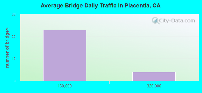
- 1,303,781Total average daily traffic
- 25,891Total average daily truck traffic
- National Bridge Inventory (NBI) Registered Bridges for Placentia
- No street view available for this location
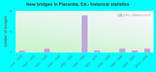
- New bridges - historical statistics
- 11910-1919
- 21930-1939
- 181960-1969
- 11970-1979
- 21990-1999
- 12000-2009
- 22010-2019
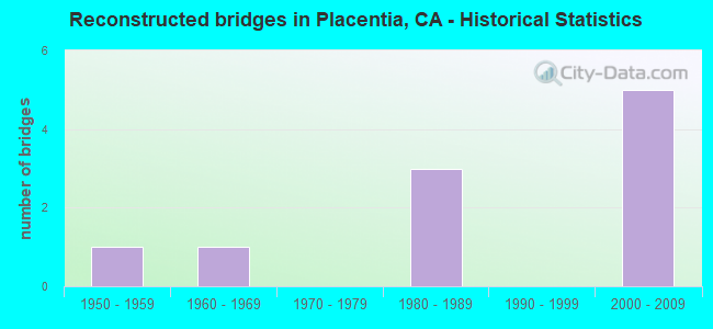
- Reconstructed bridges - Historical Statistics
- 11950-1959
- 11960-1969
- 01970-1979
- 31980-1989
- 01990-1999
- 52000-2009
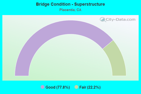
- Bridge Condition - Superstructure
- 77.8%Good
- 22.2%Fair
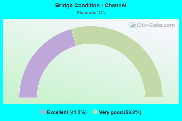
- Bridge Condition - Channel
- 41.2%Excellent
- 58.8%Very good
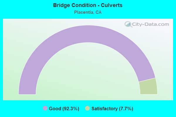
- Bridge Condition - Culverts
- 92.3%Good
- 7.7%Satisfactory
Find on map >> Show street view
Structure Number: 55 0449, Location: 12-ORA-057-16.84-PLCN (Lat: 33.867397, Lng: -117.878725), Route carried "on" structure: State highway 57, Year Built: 1969, Year Reconstructed: 2013, Status: Open, Structure Length: 4.88m (16.01ft), Average Daily Traffic: 271,000 (year 2010), Average Future Daily Traffic: 359,000 (year 2040), Design Load: HS 20+Mod, Features Intersected: BNSF RY
Minimum Vertical Clearance: 30+ m (98+ ft), Kilometerpoint: 16.840, Lanes on structure: 12, Base Highway Network: Yes (, Subroute: 1), Owner: State Highway Agency, Approaching Roadway Width: 53.5m (175.5ft), Skew: 30 degrees, Material/Design: Concrete continuous, Design/Construction: Girder and Floorbeam System, Number Of Spans In Main Unit: 3, Length of Maximum Span: 21.0m (68.9ft), Curb-To-Curb Width: 53.5m (175.5ft), Out-to-Out Width: 55.0m (180.4ft)
Condition: Deck: Good, Superstructure: Good, Substructure: Good, Operating Rating: 35.0 metric tons, Method Used To Determine Operating Rating: Load and Resistance Factor Rating (LRFR) rating reported by rating factor(RF) method using HL-93 loadings, Inventory Rating: 27.2 metric tons, Method Used To Determine Inventory Rating: Load and Resistance Factor Rating (LRFR) rating reported by rating factor(RF) method using HL-93 loadings, Structural Evaluation: Equal to present minimum criteria, Deck Geometry: Superior to present desirable criteria, Underclear: Better than present minimum criteria, Approach Roadway Alignment: Equal to present desirable criteria, Designated Inspection Frequency: Every 24 months, Inspection Date: May 2020, Deck Structure Type: Concrete Cast-file-Place, Wearing Surface/Protective System: Wearing Surface: Integral Concrete
Find on map >> Show street view
Structure Number: 55 045, Location: 12-ORA-057-16.63-PLCN (Lat: 33.864508, Lng: -117.877964), Route carried "on" structure: State highway 57, Year Built: 1969, Year Reconstructed: 2013, Status: Open, Structure Length: 3.11m (10.20ft), Average Daily Traffic: 271,000 (year 2010), Average Future Daily Traffic: 359,000 (year 2040), Design Load: HS 20+Mod, Features Intersected: BNSF RY SPUR TRACK
Minimum Vertical Clearance: 30+ m (98+ ft), Kilometerpoint: 16.630, Lanes on structure: 13, Base Highway Network: Yes (, Subroute: 1), Owner: State Highway Agency, Approaching Roadway Width: 61.5m (201.8ft), Skew: 30 degrees, Material/Design: Concrete, Design/Construction: Girder and Floorbeam System, Number Of Spans In Main Unit: 3, Length of Maximum Span: 12.2m (40.0ft), Curb-To-Curb Width: 61.5m (201.8ft), Out-to-Out Width: 62.7m (205.7ft)
Condition: Deck: Good, Superstructure: Good, Substructure: Good, Operating Rating: 39.2 metric tons, Method Used To Determine Operating Rating: Load and Resistance Factor Rating (LRFR) rating reported by rating factor(RF) method using HL-93 loadings, Inventory Rating: 27.5 metric tons, Method Used To Determine Inventory Rating: Load and Resistance Factor Rating (LRFR) rating reported by rating factor(RF) method using HL-93 loadings, Structural Evaluation: Equal to present minimum criteria, Deck Geometry: Superior to present desirable criteria, Underclear: Better than present minimum criteria, Approach Roadway Alignment: Equal to present desirable criteria, Designated Inspection Frequency: Every 24 months, Inspection Date: May 2020, Deck Structure Type: Concrete Cast-file-Place
Find on map >> Show street view
Structure Number: 55 0457, Location: 12-ORA-057-16.74-PLCN (Lat: 33.866106, Lng: -117.878336), Route carried "on" structure: State highway 57, Year Built: 1969, Year Reconstructed: 2013, Status: Open, Structure Length: 4.63m (15.19ft), Average Daily Traffic: 271,000 (year 2010), Average Future Daily Traffic: 359,000 (year 2040), Design Load: HS 20+Mod, Features Intersected: CROWTHER AVE
Minimum Vertical Clearance: 30+ m (98+ ft), Kilometerpoint: 16.740, Lanes on structure: 12, Lanes under structure: 2, Base Highway Network: Yes (, Subroute: 1), Owner: State Highway Agency, Approaching Roadway Width: 55.5m (182.1ft), Skew: 30 degrees, Material/Design: Prestressed concrete, Design/Construction: Box Beam or Girders - Multiple, Number Of Spans In Main Unit: 1, Length of Maximum Span: 45.7m (149.9ft), Curb-To-Curb Width: 55.5m (182.1ft), Out-to-Out Width: 56.7m (186.0ft)
Condition: Deck: Good, Superstructure: Good, Substructure: Good, Operating Rating: 58.6 metric tons, Method Used To Determine Operating Rating: Load and Resistance Factor Rating (LRFR) rating reported by rating factor(RF) method using HL-93 loadings, Inventory Rating: 45.4 metric tons, Method Used To Determine Inventory Rating: Load and Resistance Factor Rating (LRFR) rating reported by rating factor(RF) method using HL-93 loadings, Structural Evaluation: Better than present minimum criteria, Deck Geometry: Superior to present desirable criteria, Underclear: Somewhat better than minimum adequacy, Approach Roadway Alignment: Equal to present desirable criteria, Designated Inspection Frequency: Every 24 months, Inspection Date: May 2020, Deck Structure Type: Concrete Cast-file-Place
Find on map >> Show street view
Structure Number: 55 0459, Location: 12-ORA-057-16.39-PLCN (Lat: 33.861158, Lng: -117.876944), Route carried "on" structure: State highway 57, Year Built: 1969, Year Reconstructed: 2013, Status: Open, Structure Length: 5.30m (17.39ft), Average Daily Traffic: 273,000 (year 2010), Truck Traffic: 8%, Average Future Daily Traffic: 361,000 (year 2040), Design Load: HS 20, Features Intersected: ORANGETHORPE AVE
Minimum Vertical Clearance: 30+ m (98+ ft), Kilometerpoint: 16.390, Lanes on structure: 14, Lanes under structure: 8, Base Highway Network: Yes (, Subroute: 1), Owner: State Highway Agency, Approaching Roadway Width: 64.0m (210.0ft), Skew: 30 degrees, Material/Design: Concrete continuous, Design/Construction: Box Beam or Girders - Multiple, Number Of Spans In Main Unit: 2, Length of Maximum Span: 27.7m (90.9ft), Curb-To-Curb Width: 64.0m (210.0ft), Out-to-Out Width: 66.0m (216.5ft)
Condition: Deck: Good, Superstructure: Good, Substructure: Good, Operating Rating: 54.1 metric tons, Method Used To Determine Operating Rating: Assigned rating based on Load Factor Design (LFD) reported in metric tons, Inventory Rating: 32.4 metric tons, Method Used To Determine Inventory Rating: Assigned rating based on Load Factor Design (LFD) reported in metric tons, Structural Evaluation: Better than present minimum criteria, Deck Geometry: Superior to present desirable criteria, Underclear: Somewhat better than minimum adequacy, Approach Roadway Alignment: Equal to present desirable criteria, Designated Inspection Frequency: Every 24 months, Inspection Date: May 2020, Deck Structure Type: Concrete Cast-file-Place
Find on map >> Show street view
Structure Number: 55 0527K, Location: 12-ORA-057-16.50-PLCN (Lat: 33.862500, Lng: -117.878603), Route carried "on" structure: Ramp State highway 57, Year Built: 1969, Status: Open, Structure Length: 0.98m (3.22ft), Average Daily Traffic: 7,970 (year 2010), Truck Traffic: 7%, Average Future Daily Traffic: 9,155 (year 2040), Features Intersected: PLACENTIA CHANNEL
Minimum Vertical Clearance: 30+ m (98+ ft), Kilometerpoint: 16.500, Lanes on structure: 4, Base Highway Network: Yes, Owner: State Highway Agency, Approaching Roadway Width: 8.2m (26.9ft), Material/Design: Concrete continuous, Design/Construction: Culvert, Number Of Spans In Main Unit: 3, Length of Maximum Span: 3.0m (9.8ft), Curb-To-Curb Width: 8.2m (26.9ft), Out-to-Out Width: 9.2m (30.2ft)
Condition: Channel: Very good, Culverts: Good, Operating Rating: 54.1 metric tons, Method Used To Determine Operating Rating: Field evaluation and documented engineering judgment, Inventory Rating: 32.4 metric tons, Method Used To Determine Inventory Rating: Field evaluation and documented engineering judgment, Structural Evaluation: Better than present minimum criteria, Deck Geometry: High priority of replacement, Waterway Adequacy: Equal to present desirable criteria, Approach Roadway Alignment: Equal to present desirable criteria, Designated Inspection Frequency: Every 24 months, Inspection Date: May 2020
Find on map >> Show street view
Structure Number: 55C0068, Location: 0.1 MI. S/O ORANGETHORPE (Lat: 33.858494, Lng: -117.883317), Route carried "on" structure: City street , Year Built: 1970, Status: Open, Structure Length: 1.10m (3.61ft), Average Daily Traffic: 17,800 (year 2015), Truck Traffic: 1%, Average Future Daily Traffic: 40,211 (year 2038), Design Load: HS 20, Features Intersected: CARBON CREEK CHANNEL, Facility Carried by Structure: PLACENTIA AVENUE
Minimum Vertical Clearance: 30+ m (98+ ft), Kilometerpoint: 0.000, Lanes on structure: 5, Owner: City or Municipal Highway Agency, Approaching Roadway Width: 22.4m (73.5ft), Skew: 1 degrees, Material/Design: Concrete, Design/Construction: Culvert, Number Of Spans In Main Unit: 3, Length of Maximum Span: 3.4m (11.2ft), Curb or Sidewalk Widths: Left: 0.2m (0.7ft), Right: 1.7m (5.6ft), Curb-To-Curb Width: 19.5m (64.0ft), Out-to-Out Width: 31.1m (102.0ft)
Condition: Channel: Excellent, Culverts: Good, Operating Rating: 40.5 metric tons, Method Used To Determine Operating Rating: Field evaluation and documented engineering judgment, Inventory Rating: 24.3 metric tons, Method Used To Determine Inventory Rating: Field evaluation and documented engineering judgment, Structural Evaluation: Equal to present minimum criteria, Deck Geometry: Meets minimum limits, Waterway Adequacy: Superior to present desirable criteria, Approach Roadway Alignment: Equal to present desirable criteria, Designated Inspection Frequency: Every 24 months, Inspection Date: June 2021
Find on map >> Show street view
Structure Number: 55C0078, Location: 0.1 MI. S/O ORANGETHORPE (Lat: 33.866428, Lng: -117.825925), Route carried "on" structure: City street , Year Built: 1964, Year Reconstructed: 2014, Status: Open, Structure Length: 0.67m (2.20ft), Average Daily Traffic: 8,700 (year 2015), Truck Traffic: 1%, Average Future Daily Traffic: 16,818 (year 2038), Features Intersected: CABRON CREEK CHANNEL, Facility Carried by Structure: RICHFIELD ROAD
Minimum Vertical Clearance: 30+ m (98+ ft), Kilometerpoint: 0.000, Lanes on structure: 5, Owner: City or Municipal Highway Agency, Approaching Roadway Width: 19.2m (63.0ft), Skew: 1 degrees, Material/Design: Concrete, Design/Construction: Culvert, Number Of Spans In Main Unit: 2, Length of Maximum Span: 3.0m (9.8ft), Curb or Sidewalk Widths: Left: 3.1m (10.2ft), Right: 2.2m (7.2ft), Curb-To-Curb Width: 18.9m (62.0ft), Out-to-Out Width: 24.8m (81.4ft)
Condition: Channel: Very good, Culverts: Good, Operating Rating: 40.5 metric tons, Method Used To Determine Operating Rating: Field evaluation and documented engineering judgment, Inventory Rating: 24.3 metric tons, Method Used To Determine Inventory Rating: Field evaluation and documented engineering judgment, Structural Evaluation: Equal to present minimum criteria, Deck Geometry: Meets minimum limits, Waterway Adequacy: Equal to present desirable criteria, Approach Roadway Alignment: Equal to present desirable criteria, Designated Inspection Frequency: Every 24 months, Inspection Date: June 2021, Deck Structure Type: Concrete Cast-file-Place, Wearing Surface/Protective System: Wearing Surface: Bituminous
Find on map >> Show street view
Structure Number: 55C0143, Location: 0.1 MI. W/O JEFFERSON ST (Lat: 33.868042, Lng: -117.839261), Route carried "on" structure: City street , Year Built: 1964, Status: Open, Structure Length: 1.55m (5.09ft), Average Daily Traffic: 16,800 (year 2015), Truck Traffic: 1%, Average Future Daily Traffic: 46,561 (year 2038), Design Load: HS 20, Features Intersected: RICHFIELD CHANNEL (E05), Facility Carried by Structure: ORANGETHORPE AVE.
Minimum Vertical Clearance: 30+ m (98+ ft), Kilometerpoint: 0.000, Lanes on structure: 5, Base Highway Network: Yes, Owner: City or Municipal Highway Agency, Approaching Roadway Width: 23.4m (76.8ft), Skew: 9 degrees, Material/Design: Concrete, Design/Construction: Culvert, Number Of Spans In Main Unit: 3, Length of Maximum Span: 4.9m (16.1ft), Curb or Sidewalk Widths: Left: 1.5m (4.9ft), Right: 0.0m, Curb-To-Curb Width: 23.4m (76.8ft), Out-to-Out Width: 29.3m (96.1ft)
Condition: Channel: Excellent, Culverts: Good, Operating Rating: 40.5 metric tons, Method Used To Determine Operating Rating: Field evaluation and documented engineering judgment, Inventory Rating: 24.3 metric tons, Method Used To Determine Inventory Rating: Field evaluation and documented engineering judgment, Structural Evaluation: Equal to present minimum criteria, Deck Geometry: Better than present minimum criteria, Waterway Adequacy: Superior to present desirable criteria, Approach Roadway Alignment: Equal to present desirable criteria, Designated Inspection Frequency: Every 24 months, Inspection Date: October 2021
Find on map >> Show street view
Structure Number: 55C0192, Location: 0.2 MI W/O ROSE DRIVE (Lat: 33.903878, Lng: -117.846056), Route carried "on" structure: City street , Year Built: 1934, Status: Open, Structure Length: 1.04m (3.41ft), Average Daily Traffic: 3,700 (year 2015), Truck Traffic: 1%, Average Future Daily Traffic: 10,512 (year 2038), Features Intersected: CARBON CANYON CHANNEL, Facility Carried by Structure: GOLDEN AVENUE
Minimum Vertical Clearance: 30+ m (98+ ft), Kilometerpoint: 0.000, Lanes on structure: 2, Owner: City or Municipal Highway Agency, Approaching Roadway Width: 12.5m (41.0ft), Skew: 1 degrees, Material/Design: Concrete, Design/Construction: Arch - Deck, Number Of Spans In Main Unit: 1, Length of Maximum Span: 9.1m (29.9ft), Curb-To-Curb Width: 7.3m (24.0ft), Out-to-Out Width: 8.2m (26.9ft)
Condition: Superstructure: Fair, Substructure: Good, Channel: Excellent, Operating Rating: 25.9 metric tons, Method Used To Determine Operating Rating: Field evaluation and documented engineering judgment, Inventory Rating: 15.6 metric tons, Method Used To Determine Inventory Rating: Field evaluation and documented engineering judgment, Structural Evaluation: Meets minimum limits, Deck Geometry: High priority of replacement, Waterway Adequacy: Superior to present desirable criteria, Approach Roadway Alignment: Equal to present desirable criteria, Designated Inspection Frequency: Every 24 months, Inspection Date: June 2021
Find on map >> Show street view
Structure Number: 55C029, Location: 100' S/O MALVERN AVE (Lat: 33.874800, Lng: -117.941869), Route carried "on" structure: City street , Year Built: 1936, Year Reconstructed: 1957, Status: Open, Structure Length: 1.31m (4.30ft), Average Daily Traffic: 32,900 (year 2017), Truck Traffic: 1%, Average Future Daily Traffic: 48,782 (year 2043), Design Load: H 15, Features Intersected: BREA CREEK CHANNEL, Facility Carried by Structure: EUCLID STREET
Minimum Vertical Clearance: 30+ m (98+ ft), Kilometerpoint: 0.000, Lanes on structure: 5, Base Highway Network: Yes, Owner: City or Municipal Highway Agency, Approaching Roadway Width: 19.8m (65.0ft), Material/Design: Concrete, Design/Construction: Slab, Number Of Spans In Main Unit: 1, Length of Maximum Span: 11.3m (37.1ft), Curb or Sidewalk Widths: Left: 1.8m (5.9ft), Right: 2.6m (8.5ft), Curb-To-Curb Width: 19.8m (65.0ft), Out-to-Out Width: 24.4m (80.1ft)
Condition: Deck: Good, Superstructure: Good, Substructure: Good, Channel: Excellent, Operating Rating: 56.1 metric tons, Method Used To Determine Operating Rating: Load Factor (LF), Inventory Rating: 33.7 metric tons, Method Used To Determine Inventory Rating: Load Factor (LF), Structural Evaluation: Better than present minimum criteria, Deck Geometry: Meets minimum limits, Waterway Adequacy: Superior to present desirable criteria, Approach Roadway Alignment: Equal to present desirable criteria, Designated Inspection Frequency: Every 48 months, Inspection Date: September 2021, Deck Structure Type: Concrete Cast-file-Place, Wearing Surface/Protective System: Wearing Surface: Bituminous
Find on map >> Show street view
Structure Number: 55C0299, Location: 0.2 MI. W/O ROSE DRIVE (Lat: 33.883239, Lng: -117.847328), Route carried "on" structure: City street , Year Built: 1967, Year Reconstructed: 1987, Status: Open, Structure Length: 0.71m (2.33ft), Average Daily Traffic: 9,200 (year 2015), Truck Traffic: 1%, Average Future Daily Traffic: 16,818 (year 2036), Features Intersected: CARBON CANYON CHANNEL, Facility Carried by Structure: PALM DRIVE
Minimum Vertical Clearance: 30+ m (98+ ft), Kilometerpoint: 0.000, Lanes on structure: 4, Owner: City or Municipal Highway Agency, Approaching Roadway Width: 19.3m (63.3ft), Skew: 9 degrees, Material/Design: Concrete, Design/Construction: Culvert, Number Of Spans In Main Unit: 1, Length of Maximum Span: 6.7m (22.0ft), Curb or Sidewalk Widths: Left: 2.4m (7.9ft), Right: 2.3m (7.5ft), Curb-To-Curb Width: 19.3m (63.3ft), Out-to-Out Width: 24.3m (79.7ft)
Condition: Channel: Very good, Culverts: Good, Operating Rating: 54.1 metric tons, Method Used To Determine Operating Rating: Field evaluation and documented engineering judgment, Inventory Rating: 32.4 metric tons, Method Used To Determine Inventory Rating: Field evaluation and documented engineering judgment, Structural Evaluation: Better than present minimum criteria, Deck Geometry: Equal to present minimum criteria, Waterway Adequacy: Equal to present desirable criteria, Approach Roadway Alignment: Equal to present desirable criteria, Designated Inspection Frequency: Every 48 months, Inspection Date: June 2019
Find on map >> Show street view
Structure Number: 55C03, Location: 0.3 MI. W/O ORANGETHORPE (Lat: 33.870339, Lng: -117.851233), Route carried "on" structure: City street , Year Built: 1967, Status: Open, Structure Length: 1.19m (3.90ft), Average Daily Traffic: 11,000 (year 2015), Truck Traffic: 1%, Average Future Daily Traffic: 23,280 (year 2038), Design Load: HS 20, Features Intersected: CARBON CANYON CHANNEL, Facility Carried by Structure: CHAPMAN AVENUE
Minimum Vertical Clearance: 30+ m (98+ ft), Kilometerpoint: 0.000, Lanes on structure: 4, Base Highway Network: Yes, Owner: City or Municipal Highway Agency, Approaching Roadway Width: 24.1m (79.1ft), Skew: 34 degrees, Material/Design: Concrete, Design/Construction: Culvert, Number Of Spans In Main Unit: 3, Length of Maximum Span: 5.1m (16.7ft), Curb or Sidewalk Widths: Left: 2.4m (7.9ft), Right: 2.4m (7.9ft), Curb-To-Curb Width: 24.1m (79.1ft), Out-to-Out Width: 32.3m (106.0ft)
Condition: Channel: Very good, Culverts: Good, Operating Rating: 40.5 metric tons, Method Used To Determine Operating Rating: Field evaluation and documented engineering judgment, Inventory Rating: 24.3 metric tons, Method Used To Determine Inventory Rating: Field evaluation and documented engineering judgment, Structural Evaluation: Equal to present minimum criteria, Deck Geometry: Superior to present desirable criteria, Waterway Adequacy: Superior to present desirable criteria, Approach Roadway Alignment: Equal to present desirable criteria, Designated Inspection Frequency: Every 24 months, Inspection Date: June 2021
Find on map >> Show street view
Structure Number: 55C0303, Location: 0.1 MI. S/O ORANGETHORPE (Lat: 33.866589, Lng: -117.831214), Route carried "on" structure: City street , Year Built: 1965, Status: Open, Structure Length: 0.67m (2.20ft), Average Daily Traffic: 4,300 (year 2015), Truck Traffic: 1%, Average Future Daily Traffic: 18,921 (year 2038), Features Intersected: CARBON CREEK CHANNEL, Facility Carried by Structure: VAN BUREN STREET
Minimum Vertical Clearance: 30+ m (98+ ft), Kilometerpoint: 0.000, Lanes on structure: 3, Owner: City or Municipal Highway Agency, Approaching Roadway Width: 15.2m (49.9ft), Material/Design: Concrete, Design/Construction: Culvert, Number Of Spans In Main Unit: 2, Length of Maximum Span: 3.0m (9.8ft), Curb or Sidewalk Widths: Left: 0.2m (0.7ft), Right: 0.2m (0.7ft), Curb-To-Curb Width: 12.0m (39.4ft), Out-to-Out Width: 12.8m (42.0ft)
Condition: Channel: Very good, Culverts: Satisfactory, Operating Rating: 40.5 metric tons, Method Used To Determine Operating Rating: Field evaluation and documented engineering judgment, Inventory Rating: 24.3 metric tons, Method Used To Determine Inventory Rating: Field evaluation and documented engineering judgment, Structural Evaluation: Equal to present minimum criteria, Deck Geometry: Meets minimum limits, Waterway Adequacy: Equal to present desirable criteria, Approach Roadway Alignment: Equal to present desirable criteria, Designated Inspection Frequency: Every 24 months, Inspection Date: October 2021
Find on map >> Show street view
Structure Number: 55C0314, Location: 0.5 MI. N/O LA PALMA AVE. (Lat: 33.866344, Lng: -117.823428), Route carried "on" structure: City street , Year Built: 1965, Status: Open, Structure Length: 0.67m (2.20ft), Average Daily Traffic: 210 (year 2015), Truck Traffic: 2%, Average Future Daily Traffic: 210 (year 2038), Features Intersected: ATWOOD CHANNEL, Facility Carried by Structure: FEE ANA STREET
Minimum Vertical Clearance: 30+ m (98+ ft), Kilometerpoint: 0.000, Lanes on structure: 2, Owner: City or Municipal Highway Agency, Approaching Roadway Width: 15.5m (50.9ft), Material/Design: Concrete, Design/Construction: Culvert, Number Of Spans In Main Unit: 2, Length of Maximum Span: 3.0m (9.8ft), Curb-To-Curb Width: 9.0m (29.5ft), Out-to-Out Width: 9.8m (32.2ft)
Condition: Channel: Excellent, Culverts: Good, Operating Rating: 40.5 metric tons, Method Used To Determine Operating Rating: Field evaluation and documented engineering judgment, Inventory Rating: 24.3 metric tons, Method Used To Determine Inventory Rating: Field evaluation and documented engineering judgment, Structural Evaluation: Equal to present minimum criteria, Deck Geometry: Equal to present minimum criteria, Waterway Adequacy: Superior to present desirable criteria, Approach Roadway Alignment: Equal to present desirable criteria, Designated Inspection Frequency: Every 24 months, Inspection Date: October 2021
Find on map >> Show street view
Structure Number: 55C0315, Location: 0.3 MI. N/O ORANGETHORPE (Lat: 33.872017, Lng: -117.831303), Route carried "on" structure: City street , Year Built: 1964, Year Reconstructed: 1992, Status: Open, Structure Length: 0.91m (2.99ft), Average Daily Traffic: 4,300 (year 2015), Truck Traffic: 1%, Average Future Daily Traffic: 18,921 (year 2038), Features Intersected: RICHFIELD CHANNEL, Facility Carried by Structure: VAN BUREN STREET
Minimum Vertical Clearance: 30+ m (98+ ft), Kilometerpoint: 0.000, Lanes on structure: 2, Owner: City or Municipal Highway Agency, Approaching Roadway Width: 17.6m (57.7ft), Material/Design: Concrete, Design/Construction: Culvert, Number Of Spans In Main Unit: 3, Length of Maximum Span: 2.7m (8.9ft), Curb or Sidewalk Widths: Left: 1.5m (4.9ft), Right: 1.5m (4.9ft), Curb-To-Curb Width: 17.6m (57.7ft), Out-to-Out Width: 25.5m (83.7ft)
Condition: Channel: Very good, Culverts: Good, Operating Rating: 40.5 metric tons, Method Used To Determine Operating Rating: Field evaluation and documented engineering judgment, Inventory Rating: 24.3 metric tons, Method Used To Determine Inventory Rating: Field evaluation and documented engineering judgment, Structural Evaluation: Equal to present minimum criteria, Deck Geometry: Superior to present desirable criteria, Waterway Adequacy: Equal to present desirable criteria, Approach Roadway Alignment: Equal to present desirable criteria, Designated Inspection Frequency: Every 24 months, Inspection Date: October 2021
Find on map >> Show street view
Structure Number: 55C0316, Location: 0.1 MI. N/O ORANGETHORPE (Lat: 33.869769, Lng: -117.836917), Route carried "on" structure: City street , Year Built: 1964, Year Reconstructed: 1992, Status: Open, Structure Length: 1.55m (5.09ft), Average Daily Traffic: 4,700 (year 2015), Truck Traffic: 3%, Average Future Daily Traffic: 8,466 (year 2038), Design Load: HS 20, Features Intersected: RICHFIELD CHANNEL, Facility Carried by Structure: JEFFERSON STREET
Minimum Vertical Clearance: 30+ m (98+ ft), Kilometerpoint: 0.000, Lanes on structure: 5, Owner: City or Municipal Highway Agency, Approaching Roadway Width: 19.4m (63.6ft), Skew: 4 degrees, Material/Design: Concrete, Design/Construction: Culvert, Number Of Spans In Main Unit: 3, Length of Maximum Span: 4.8m (15.7ft), Curb or Sidewalk Widths: Left: 1.5m (4.9ft), Right: 1.5m (4.9ft), Curb-To-Curb Width: 19.4m (63.6ft), Out-to-Out Width: 25.3m (83.0ft)
Condition: Channel: Very good, Culverts: Good, Operating Rating: 40.5 metric tons, Method Used To Determine Operating Rating: Field evaluation and documented engineering judgment, Inventory Rating: 24.3 metric tons, Method Used To Determine Inventory Rating: Field evaluation and documented engineering judgment, Structural Evaluation: Equal to present minimum criteria, Deck Geometry: Meets minimum limits, Waterway Adequacy: Equal to present desirable criteria, Approach Roadway Alignment: Equal to present desirable criteria, Designated Inspection Frequency: Every 24 months, Inspection Date: October 2021
Find on map >> Show street view
Structure Number: 55C0355, Location: 100' W/O ROUTE 57 FWY. (Lat: 33.859733, Lng: -117.877411), Route carried "on" structure: City street , Year Built: 1969, Status: Open, Structure Length: 0.94m (3.08ft), Average Daily Traffic: 1,000 (year 2015), Truck Traffic: 1%, Average Future Daily Traffic: 2,116 (year 2038), Design Load: HS 20, Features Intersected: PLACENTIA STORM CHANNEL, Facility Carried by Structure: IOWA PLACE
Minimum Vertical Clearance: 30+ m (98+ ft), Kilometerpoint: 0.000, Lanes on structure: 2, Owner: City or Municipal Highway Agency, Approaching Roadway Width: 10.4m (34.1ft), Material/Design: Concrete, Design/Construction: Culvert, Number Of Spans In Main Unit: 3, Length of Maximum Span: 3.0m (9.8ft), Curb-To-Curb Width: 5.5m (18.0ft), Out-to-Out Width: 5.9m (19.4ft)
Condition: Channel: Very good, Culverts: Good, Operating Rating: 54.1 metric tons, Method Used To Determine Operating Rating: Field evaluation and documented engineering judgment, Inventory Rating: 32.4 metric tons, Method Used To Determine Inventory Rating: Field evaluation and documented engineering judgment, Structural Evaluation: Better than present minimum criteria, Deck Geometry: High priority of replacement, Waterway Adequacy: Equal to present desirable criteria, Approach Roadway Alignment: Equal to present minimum criteria, Designated Inspection Frequency: Every 48 months, Inspection Date: June 2021
Find on map >> Show street view
Structure Number: 55C0356, Location: 100' W/O ROUTE 57 FWY. (Lat: 33.865969, Lng: -117.879308), Route carried "on" structure: City street , Year Built: 1969, Status: Open, Structure Length: 0.64m (2.10ft), Average Daily Traffic: 4,500 (year 2015), Truck Traffic: 1%, Average Future Daily Traffic: 16,931 (year 2038), Design Load: HS 20, Features Intersected: PLACENTIA STORM CHANNEL, Facility Carried by Structure: CROWTHER AVENUE
Minimum Vertical Clearance: 30+ m (98+ ft), Kilometerpoint: 0.000, Lanes on structure: 5, Owner: City or Municipal Highway Agency, Approaching Roadway Width: 19.4m (63.6ft), Material/Design: Concrete, Design/Construction: Culvert, Number Of Spans In Main Unit: 2, Length of Maximum Span: 3.0m (9.8ft), Curb or Sidewalk Widths: Left: 0.2m (0.7ft), Right: 0.2m (0.7ft), Curb-To-Curb Width: 19.4m (63.6ft), Out-to-Out Width: 24.8m (81.4ft)
Condition: Channel: Excellent, Culverts: Good, Operating Rating: 40.5 metric tons, Method Used To Determine Operating Rating: Field evaluation and documented engineering judgment, Inventory Rating: 24.3 metric tons, Method Used To Determine Inventory Rating: Field evaluation and documented engineering judgment, Structural Evaluation: Equal to present minimum criteria, Deck Geometry: Meets minimum limits, Waterway Adequacy: Superior to present desirable criteria, Approach Roadway Alignment: Equal to present desirable criteria, Designated Inspection Frequency: Every 24 months, Inspection Date: June 2021
Find on map >> Show street view
Structure Number: 55C0544, Location: 0.1 MI E/O YORBA LINDA BL (Lat: 33.889422, Lng: -117.845433), Route carried "on" structure: City street , Year Built: 1912, Year Reconstructed: 1974, Status: Open, Structure Length: 1.28m (4.20ft), Average Daily Traffic: 1,000 (year 2015), Truck Traffic: 1%, Average Future Daily Traffic: 2,102 (year 2038), Features Intersected: CARBON CANYON CHANNEL, Facility Carried by Structure: YORBA PLACE
Minimum Vertical Clearance: 30+ m (98+ ft), Kilometerpoint: 0.000, Lanes on structure: 2, Owner: City or Municipal Highway Agency, Approaching Roadway Width: 8.5m (27.9ft), Skew: 2 degrees, Material/Design: Concrete, Design/Construction: Arch - Deck, Number Of Spans In Main Unit: 1, Length of Maximum Span: 12.2m (40.0ft), Curb or Sidewalk Widths: Left: 0.0m, Right: 1.0m (3.3ft), Curb-To-Curb Width: 7.7m (25.3ft), Out-to-Out Width: 9.4m (30.8ft)
Condition: Deck: Good, Superstructure: Fair, Substructure: Good, Channel: Very good, Operating Rating: 25.9 metric tons, Method Used To Determine Operating Rating: Field evaluation and documented engineering judgment, Inventory Rating: 15.6 metric tons, Method Used To Determine Inventory Rating: Field evaluation and documented engineering judgment, Structural Evaluation: Meets minimum limits, Deck Geometry: Meets minimum limits, Waterway Adequacy: Equal to present desirable criteria, Approach Roadway Alignment: Equal to present desirable criteria, Designated Inspection Frequency: Every 24 months, Inspection Date: June 2021, Deck Structure Type: Concrete Cast-file-Place, Wearing Surface/Protective System: Wearing Surface: Bituminous
Find on map >> Show street view
Structure Number: 55C0618M, Location: AT DUNNAVANT DRIVE (Lat: 33.875872, Lng: -117.848717), Route carried "on" structure: City street , Year Built: 1992, Status: Open, Structure Length: 1.01m (3.31ft), Average Daily Traffic: 12,200 (year 2015), Truck Traffic: 1%, Average Future Daily Traffic: 16,818 (year 2038), Features Intersected: CARBON CANYON CHANNEL, Facility Carried by Structure: ALTA VISTA STREET
Minimum Vertical Clearance: 30+ m (98+ ft), Kilometerpoint: 0.000, Lanes on structure: 5, Owner: City or Municipal Highway Agency, Approaching Roadway Width: 19.5m (64.0ft), Skew: 1 degrees, Material/Design: Concrete, Design/Construction: Culvert, Number Of Spans In Main Unit: 2, Length of Maximum Span: 4.9m (16.1ft), Curb-To-Curb Width: 19.5m (64.0ft), Out-to-Out Width: 22.0m (72.2ft)
Condition: Channel: Excellent, Culverts: Good, Operating Rating: 54.1 metric tons, Method Used To Determine Operating Rating: Field evaluation and documented engineering judgment, Inventory Rating: 32.4 metric tons, Method Used To Determine Inventory Rating: Field evaluation and documented engineering judgment, Structural Evaluation: Better than present minimum criteria, Deck Geometry: Meets minimum limits, Waterway Adequacy: Superior to present desirable criteria, Approach Roadway Alignment: Equal to present desirable criteria, Designated Inspection Frequency: Every 48 months, Inspection Date: June 2021
Find on map >> Show street view
Structure Number: 55C067, Location: 4.6 MI. SE/O CHAPMAN AVE. (Lat: 33.759667, Lng: -117.702819), Route carried "on" structure: ServiceOther road , Year Built: 1995, Status: Open, Structure Length: 3.65m (11.98ft), Average Daily Traffic: 1 (year 2019), Average Future Daily Traffic: 1 (year 2037), Features Intersected: SANTIAGO CANYON ROAD, Facility Carried by Structure: HICKS CNYN HAUL RD
Minimum Vertical Clearance: 30+ m (98+ ft), Kilometerpoint: 0.000, Lanes on structure: 2, Lanes under structure: 2, Owner: County Highway Agency, Approaching Roadway Width: 7.3m (24.0ft), Material/Design: Prestressed concrete, Design/Construction: Stringer/Multi-beam, Number Of Spans In Main Unit: 2, Length of Maximum Span: 22.6m (74.1ft), Curb or Sidewalk Widths: Left: 0.7m (2.3ft), Right: 0.7m (2.3ft), Curb-To-Curb Width: 7.3m (24.0ft), Out-to-Out Width: 9.1m (29.9ft)
Condition: Deck: Good, Superstructure: Good, Substructure: Good, Operating Rating: 54.1 metric tons, Method Used To Determine Operating Rating: Field evaluation and documented engineering judgment, Inventory Rating: 32.4 metric tons, Method Used To Determine Inventory Rating: Field evaluation and documented engineering judgment, Structural Evaluation: Better than present minimum criteria, Deck Geometry: Equal to present minimum criteria, Underclear: Somewhat better than minimum adequacy, Approach Roadway Alignment: Equal to present desirable criteria, Designated Inspection Frequency: Every 48 months, Inspection Date: May 2019, Deck Structure Type: Concrete Cast-file-Place
Find on map >> Show street view
Structure Number: 55C07, Location: ROSE DR/ORANGETHORPE AVE (Lat: 33.867833, Lng: -117.842586), Route carried "on" structure: City street , Year Built: 2016, Status: Open, Structure Length: 12.36m (40.55ft), Average Daily Traffic: 4,500 (year 2015), Truck Traffic: 1%, Average Future Daily Traffic: 11,000 (year 2038), Design Load: HL 93, Features Intersected: ATWOOD CHANNEL & BNSF, Facility Carried by Structure: ROSE DRIVE
Minimum Vertical Clearance: 30+ m (98+ ft), Kilometerpoint: 0.000, Lanes on structure: 6, Lanes under structure: 6, Owner: City or Municipal Highway Agency, Approaching Roadway Width: 24.4m (80.1ft), Skew: 30 degrees, Material/Design: Prestressed concrete, Design/Construction: Box Beam or Girders - Single/Spread, Number Of Spans In Main Unit: 2, Number Of Approach Spans: 1, Length of Maximum Span: 49.9m (163.7ft), Curb or Sidewalk Widths: Left: 3.0m (9.8ft), Right: 3.0m (9.8ft), Curb-To-Curb Width: 24.4m (80.1ft), Out-to-Out Width: 36.0m (118.1ft)
Condition: Deck: Good, Superstructure: Good, Substructure: Good, Channel: Very good, Operating Rating: 42.1 metric tons, Method Used To Determine Operating Rating: Assigned ratings based on Load and Resistance Factor Design (LRFD) reported by rating factor (RF) using HL93 loadings, Inventory Rating: 32.4 metric tons, Method Used To Determine Inventory Rating: Assigned ratings based on Load and Resistance Factor Design (LRFD) reported by rating factor (RF) using HL93 loadings, Structural Evaluation: Better than present minimum criteria, Deck Geometry: Somewhat better than minimum adequacy, Underclear: High priority of corrective action, Waterway Adequacy: Equal to present desirable criteria, Approach Roadway Alignment: Equal to present desirable criteria, Designated Inspection Frequency: Every 24 months, Inspection Date: October 2021, Deck Structure Type: Concrete Cast-file-Place
Find on map >> Show street view
Structure Number: 55 0457, Location: 12-ORA-057-16.74-PLCN (Lat: 33.866106, Lng: -117.878336), Route carried "under" structure: City street M172, Year Built: 1969, Structure Length: 0. m, Average Daily Traffic: 10,000 (year 2010), Truck Traffic: 3%, Features Intersected: CROWTHER AVE, Facility Carried by Structure: STATE ROUTE 57
Minimum Vertical Clearance: 5.56m (18.24ft), Kilometerpoint: 0.000, Lanes on structure: 12, Lanes under structure: 2, Material/Design: Prestressed concrete, Design/Construction: Box Beam or Girders - Multiple, Length of Maximum Span: 45.7m (149.9ft)
Find on map >> Show street view
Structure Number: 55 0459, Location: 12-ORA-057-16.39-PLCN (Lat: 33.861158, Lng: -117.876944), Route carried "under" structure: City street L074, Year Built: 1969, Structure Length: 0. m, Average Daily Traffic: 20,000 (year 2010), Truck Traffic: 3%, Features Intersected: ORANGETHORPE AVE, Facility Carried by Structure: STATE ROUTE 57
Minimum Vertical Clearance: 4.69m (15.39ft), Kilometerpoint: 0.000, Lanes on structure: 14, Lanes under structure: 8, Material/Design: Concrete continuous, Design/Construction: Box Beam or Girders - Multiple, Length of Maximum Span: 27.7m (90.9ft)
Find on map >> Show street view
Structure Number: 55 046, Location: 12-ORA-057-17.02-PLCN (Lat: 33.870506, Lng: -117.879664), Route carried "under" structure: City street M181, Year Built: 1969, Structure Length: 0. m, Average Daily Traffic: 15,000 (year 2010), Truck Traffic: 3%, Features Intersected: PLACENTIA AVE, Facility Carried by Structure: STATE ROUTE 57
Minimum Vertical Clearance: 4.75m (15.58ft), Kilometerpoint: 0.000, Lanes on structure: 13, Lanes under structure: 4, Material/Design: Concrete continuous, Design/Construction: Box Beam or Girders - Multiple, Length of Maximum Span: 32.6m (107.0ft)
Find on map >> Show street view
Structure Number: 55C0679, Location: 0.07 MI N/O CROWTHER AVE. (Lat: 33.868175, Lng: -117.873869), Route carried "under" structure: City street , Year Built: 2004, Structure Length: 0. m, Average Daily Traffic: 8,000 (year 2000), Truck Traffic: 1%, Features Intersected: MELROSE STREET, Facility Carried by Structure: BN&SF RAILROAD
Minimum Vertical Clearance: 4.72m (15.49ft), Kilometerpoint: 0.000, Lanes under structure: 3, Material/Design: Prestressed concrete, Design/Construction: Stringer/Multi-beam, Length of Maximum Span: 16.6m (54.5ft)
Find on map >> Show street view
Structure Number: 55C07, Location: ROSE DR/ORANGETHORPE AVE (Lat: 33.867833, Lng: -117.842586), Route carried "under" structure: City street , Year Built: 2016, Structure Length: 0. m, Average Daily Traffic: 20,000 (year 2015), Truck Traffic: 3%, Features Intersected: ATWOOD CHANNEL & BNSF, Facility Carried by Structure: ROSE DRIVE
Minimum Vertical Clearance: 7.59m (24.90ft), Kilometerpoint: 0.000, Lanes on structure: 6, Lanes under structure: 6, Material/Design: Prestressed concrete, Design/Construction: Box Beam or Girders - Single/Spread, Length of Maximum Span: 49.9m (163.7ft)