Bridge Statistics for Pentwater, Michigan (MI)
Condition, Traffic, Stress, Structural Evaluation, Project Costs
- National Bridge Inventory (NBI) Statistics
- 19Number of bridges
- 285ft / 87.2mTotal length
- $1,777,000Total costs
- 75,002Total average daily traffic
- 5,564Total average daily truck traffic
- National Bridge Inventory (NBI) Registered Bridges for Pentwater
- No street view available for this location
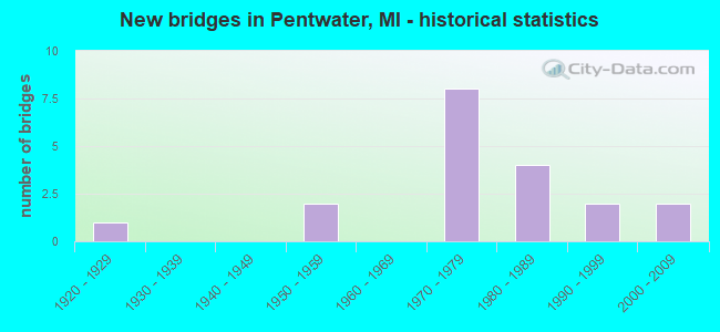
- New bridges - historical statistics
- 11920-1929
- 21950-1959
- 81970-1979
- 41980-1989
- 21990-1999
- 22000-2009


- Bridge Condition - Deck
- 66.7%Good
- 16.7%Satisfactory
- 16.7%Fair

- Bridge Condition - Superstructure
- 8.3%Very good
- 41.7%Good
- 25.0%Satisfactory
- 16.7%Fair
- 8.3%Poor

- Bridge Condition - Substructure
- 25.0%Very good
- 33.3%Good
- 25.0%Satisfactory
- 16.7%Fair

- Bridge Condition - Channel
- 27.3%Very good
- 9.1%Good
- 18.2%Satisfactory
- 27.3%Fair
- 18.2%Poor

- Bridge Condition - Culverts
- 66.7%Good
- 33.3%Satisfactory
Find on map >> Show street view
Structure Number: 6635, Location: 0.9 MI N OF OCEANA COL (Lat: 43.831836, Lng: -86.398797), Route carried "on" structure: Alternate County highway , Year Built: 1925, Status: Open, Structure Length: 0.73m (2.40ft), Average Daily Traffic: 8,600 (year 1997), Truck Traffic: 6%, Average Future Daily Traffic: 9,300 (year 2017), Design Load: H 15, Features Intersected: DURHAM CREEK, Facility Carried by Structure: OLD US-31
Minimum Vertical Clearance: 30.48m (100.00ft), Kilometerpoint: 1.543, Lanes on structure: 2, Base Highway Network: Yes (Inventory Route: 21, Subroute: 4), Owner: County Highway Agency, Approaching Roadway Width: 11.5m (37.7ft), Material/Design: Concrete, Design/Construction: Slab, Number Of Spans In Main Unit: 2, Length of Maximum Span: 3.6m (11.8ft), Curb-To-Curb Width: 13.4m (44.0ft), Out-to-Out Width: 13.8m (45.3ft)
Condition: Deck: Fair, Superstructure: Fair, Substructure: Fair, Channel: Fair, Operating Rating: 44.5 metric tons, Method Used To Determine Operating Rating: Allowable Stress (AS), Inventory Rating: 24.5 metric tons, Method Used To Determine Inventory Rating: Allowable Stress (AS), Structural Evaluation: Somewhat better than minimum adequacy, Deck Geometry: Equal to present minimum criteria, Waterway Adequacy: Equal to present minimum criteria, Approach Roadway Alignment: Equal to present minimum criteria, Designated Inspection Frequency: Every 24 months, Inspection Date: August 2020, Deck Structure Type: Concrete Cast-file-Place, Wearing Surface/Protective System: Wearing Surface: Bituminous
Find on map >> Show street view
Structure Number: 8319, Location: 2.7 MI SE OF PENTWATER (Lat: 43.763000, Lng: -86.393722), Route carried "on" structure: Business US 31, Year Built: 2001, Status: Open, Structure Length: 5.33m (17.49ft), Average Daily Traffic: 3,377 (year 2007), Truck Traffic: 3%, Average Future Daily Traffic: 4,157 (year 2018), Design Load: HS 20, Features Intersected: N BR PENTWATER RIVER
Minimum Vertical Clearance: 30.48m (100.00ft), Kilometerpoint: 15.788, Lanes on structure: 2, Owner: State Highway Agency, Approaching Roadway Width: 12.8m (42.0ft), Skew: 2 degrees, Material/Design: Prestressed concrete, Design/Construction: Box Beam or Girders - Single/Spread, Number Of Spans In Main Unit: 3, Length of Maximum Span: 23.4m (76.8ft), Curb-To-Curb Width: 13.1m (43.0ft), Out-to-Out Width: 14.2m (46.6ft)
Condition: Deck: Good, Superstructure: Good, Substructure: Good, Channel: Very good, Operating Rating: 63.8 metric tons, Method Used To Determine Operating Rating: Load Factor (LF) rating reported by rating factor (RF) method using MS18 loading, Inventory Rating: 24.3 metric tons, Method Used To Determine Inventory Rating: Load Factor (LF) rating reported by rating factor (RF) method using MS18 loading, Structural Evaluation: Equal to present minimum criteria, Deck Geometry: Equal to present minimum criteria, Waterway Adequacy: Equal to present desirable criteria, Approach Roadway Alignment: Better than present minimum criteria, Designated Inspection Frequency: Every 24 months, Inspection Date: November 2021, Deck Structure Type: Concrete Cast-file-Place, Wearing Surface/Protective System: Wearing Surface: Monolithic Concrete, Deck Protection: Epoxy Coated Reinforcing
Find on map >> Show street view
Structure Number: 832, Location: 0.6 MI S OF MASON COL (Lat: 43.818375, Lng: -86.411158), Route carried "on" structure: Business US 31, Year Built: 2000, Status: Open, Structure Length: 1.55m (5.09ft), Average Daily Traffic: 3,700 (year 2007), Truck Traffic: 2%, Average Future Daily Traffic: 3,870 (year 2018), Design Load: HS 25 or greater, Features Intersected: BASS LAKE CREEK
Minimum Vertical Clearance: 30.48m (100.00ft), Kilometerpoint: 0.039, Lanes on structure: 2, Owner: State Highway Agency, Approaching Roadway Width: 12.2m (40.0ft), Material/Design: Prestressed concrete, Design/Construction: Box Beam or Girders - Multiple, Number Of Spans In Main Unit: 1, Length of Maximum Span: 15.5m (50.9ft), Curb-To-Curb Width: 13.4m (44.0ft), Out-to-Out Width: 14.4m (47.2ft)
Condition: Deck: Good, Superstructure: Very good, Substructure: Very good, Channel: Good, Operating Rating: 87.5 metric tons, Method Used To Determine Operating Rating: Load Factor (LF) rating reported by rating factor (RF) method using MS18 loading, Inventory Rating: 52.2 metric tons, Method Used To Determine Inventory Rating: Load Factor (LF) rating reported by rating factor (RF) method using MS18 loading, Structural Evaluation: Equal to present desirable criteria, Deck Geometry: Better than present minimum criteria, Waterway Adequacy: Better than present minimum criteria, Approach Roadway Alignment: Somewhat better than minimum adequacy, Designated Inspection Frequency: Every 24 months, Inspection Date: November 2021, Deck Structure Type: Concrete Cast-file-Place, Wearing Surface/Protective System: Wearing Surface: Monolithic Concrete, Deck Protection: Epoxy Coated Reinforcing
Find on map >> Show street view
Structure Number: 8321, Location: 1.5 MI N OF S JCT US-31BS (Lat: 43.782611, Lng: -86.358536), Route carried "on" structure: County highway , Year Built: 1953, Status: Open, Structure Length: 0.82m (2.69ft), Average Daily Traffic: 1,850 (year 2006), Truck Traffic: 7%, Average Future Daily Traffic: 2,200 (year 2026), Design Load: HS 20, Features Intersected: CEDAR CREEK, Facility Carried by Structure: N OCEANA DR(OLD31)
Minimum Vertical Clearance: 30.48m (100.00ft), Kilometerpoint: 35.848, Lanes on structure: 2, Owner: County Highway Agency, Approaching Roadway Width: 10.8m (35.4ft), Material/Design: Concrete, Design/Construction: Tee Beam, Number Of Spans In Main Unit: 1, Length of Maximum Span: 7.6m (24.9ft), Curb-To-Curb Width: 12.1m (39.7ft), Out-to-Out Width: 29.3m (96.1ft)
Condition: Deck: Good, Superstructure: Satisfactory, Substructure: Satisfactory, Channel: Fair, Operating Rating: 93.6 metric tons, Method Used To Determine Operating Rating: Load Factor (LF) rating reported by rating factor (RF) method using MS18 loading, Inventory Rating: 56.1 metric tons, Method Used To Determine Inventory Rating: Load Factor (LF) rating reported by rating factor (RF) method using MS18 loading, Structural Evaluation: Equal to present minimum criteria, Deck Geometry: Equal to present minimum criteria, Waterway Adequacy: Equal to present desirable criteria, Approach Roadway Alignment: Equal to present desirable criteria, Designated Inspection Frequency: Every 24 months, Inspection Date: August 2020, Deck Structure Type: Concrete Cast-file-Place, Wearing Surface/Protective System: Wearing Surface: Other
Find on map >> Show street view
Structure Number: 8322, Location: 2.5 MI N OF S JCT US-31BS (Lat: 43.795222, Lng: -86.358844), Route carried "on" structure: County highway , Year Built: 1953, Year Reconstructed: 2001, Status: Open, Structure Length: 3.96m (12.99ft), Average Daily Traffic: 2,200 (year 2006), Truck Traffic: 7%, Average Future Daily Traffic: 1,665 (year 2015), Design Load: HS 20, Features Intersected: N BR PENTWATER RIVER, Facility Carried by Structure: N OCEANA DR(OLD31)
Minimum Vertical Clearance: 30.48m (100.00ft), Kilometerpoint: 37.251, Lanes on structure: 2, Base Highway Network: Yes (Inventory Route: 154, Subroute: 10), Owner: County Highway Agency, Approaching Roadway Width: 12.5m (41.0ft), Material/Design: Steel, Design/Construction: Stringer/Multi-beam, Number Of Spans In Main Unit: 3, Length of Maximum Span: 15.2m (49.9ft), Curb or Sidewalk Widths: Left: 0.4m (1.3ft), Right: 0.4m (1.3ft), Curb-To-Curb Width: 13.2m (43.3ft), Out-to-Out Width: 14.2m (46.6ft)
Condition: Deck: Good, Superstructure: Good, Substructure: Good, Channel: Fair, Operating Rating: 94.9 metric tons, Method Used To Determine Operating Rating: Load Factor (LF) rating reported by rating factor (RF) method using MS18 loading, Inventory Rating: 56.7 metric tons, Method Used To Determine Inventory Rating: Load Factor (LF) rating reported by rating factor (RF) method using MS18 loading, Structural Evaluation: Better than present minimum criteria, Deck Geometry: Equal to present minimum criteria, Waterway Adequacy: Superior to present desirable criteria, Approach Roadway Alignment: Better than present minimum criteria, Designated Inspection Frequency: Every 24 months, Inspection Date: August 2020, Deck Structure Type: Concrete Cast-file-Place, Wearing Surface/Protective System: Wearing Surface: Monolithic Concrete, Deck Protection: Epoxy Coated Reinforcing
Find on map >> Show street view
Structure Number: 8336, Location: 1.5 MI EAST OF PENTWATER (Lat: 43.769367, Lng: -86.389736), Route carried "on" structure: US 31, Year Built: 1980, Status: Open, Structure Length: 22.50m (73.82ft), Average Daily Traffic: 4,413 (year 2007), Truck Traffic: 10%, Average Future Daily Traffic: 5,796 (year 2018), Design Load: HS 25 or greater, Features Intersected: N BRANCH PENTWATER RIVER
Minimum Vertical Clearance: 30.48m (100.00ft), Kilometerpoint: 35.766, Lanes on structure: 3, Base Highway Network: Yes (Inventory Route: 154, Subroute: 2), Owner: State Highway Agency, Approaching Roadway Width: 12.8m (42.0ft), Material/Design: Steel continuous, Design/Construction: Stringer/Multi-beam, Number Of Spans In Main Unit: 4, Length of Maximum Span: 75.0m (246.1ft), Curb or Sidewalk Widths: Left: 0.2m (0.7ft), Right: 0.2m (0.7ft), Curb-To-Curb Width: 12.8m (42.0ft), Out-to-Out Width: 14.1m (46.3ft)
Condition: Deck: Fair, Superstructure: Poor, Substructure: Good, Channel: Very good, Operating Rating: 70.3 metric tons, Method Used To Determine Operating Rating: Load Factor (LF) rating reported by rating factor (RF) method using MS18 loading, Inventory Rating: 42.1 metric tons, Method Used To Determine Inventory Rating: Load Factor (LF) rating reported by rating factor (RF) method using MS18 loading, Structural Evaluation: Meets minimum limits, Deck Geometry: Meets minimum limits, Waterway Adequacy: Equal to present desirable criteria, Approach Roadway Alignment: Equal to present desirable criteria, Length Of Structure Improvement: 22.50m (73.82ft), Designated Inspection Frequency: Every 4 months, Inspection Date: December 2021, Bridge Improvement Cost: $864,000, Roadway Improvement Cost: $43,000, Total Project Cost: $510,000, Deck Structure Type: Concrete Cast-file-Place, Wearing Surface/Protective System: Wearing Surface: Latex Concrete, Deck Protection: Epoxy Coated Reinforcing
Find on map >> Show street view
Structure Number: 8337, Location: 1.5 MI EAST OF PENTWATER (Lat: 43.770258, Lng: -86.389278), Route carried "on" structure: US 31, Year Built: 1980, Status: Open, Structure Length: 16.95m (55.61ft), Average Daily Traffic: 4,413 (year 2007), Truck Traffic: 10%, Average Future Daily Traffic: 5,796 (year 2018), Design Load: HS 25 or greater, Features Intersected: N BRANCH PENTWATER RIVER
Minimum Vertical Clearance: 30.48m (100.00ft), Kilometerpoint: 35.816, Lanes on structure: 3, Base Highway Network: Yes (Inventory Route: 154, Subroute: 3), Owner: State Highway Agency, Approaching Roadway Width: 12.8m (42.0ft), Material/Design: Steel continuous, Design/Construction: Stringer/Multi-beam, Number Of Spans In Main Unit: 3, Length of Maximum Span: 75.0m (246.1ft), Curb-To-Curb Width: 13.4m (44.0ft), Out-to-Out Width: 14.1m (46.3ft)
Condition: Deck: Satisfactory, Superstructure: Good, Substructure: Satisfactory, Channel: Very good, Operating Rating: 63.2 metric tons, Method Used To Determine Operating Rating: Load Factor (LF) rating reported by rating factor (RF) method using MS18 loading, Inventory Rating: 37.9 metric tons, Method Used To Determine Inventory Rating: Load Factor (LF) rating reported by rating factor (RF) method using MS18 loading, Structural Evaluation: Equal to present minimum criteria, Deck Geometry: Somewhat better than minimum adequacy, Waterway Adequacy: Equal to present desirable criteria, Approach Roadway Alignment: Equal to present desirable criteria, Length Of Structure Improvement: 16.95m (55.61ft), Designated Inspection Frequency: Every 24 months, Inspection Date: April 2020, Bridge Improvement Cost: $646,000, Roadway Improvement Cost: $32,000, Total Project Cost: $380,000, Deck Structure Type: Concrete Cast-file-Place, Wearing Surface/Protective System: Wearing Surface: Monolithic Concrete, Deck Protection: Epoxy Coated Reinforcing
Find on map >> Show street view
Structure Number: 8355, Location: 4.0 MI N OF HART (Lat: 43.761558, Lng: -86.384314), Route carried "on" structure: US 31, Year Built: 1977, Status: Open, Structure Length: 3.23m (10.60ft), Average Daily Traffic: 4,413 (year 2007), Truck Traffic: 10%, Average Future Daily Traffic: 5,796 (year 2018), Design Load: HS 25 or greater, Features Intersected: US-31 BR (MONROE ROAD)
Minimum Vertical Clearance: 30.48m (100.00ft), Kilometerpoint: 34.758, Lanes on structure: 2, Lanes under structure: 2, Base Highway Network: Yes (Inventory Route: 154, Subroute: 2), Owner: State Highway Agency, Approaching Roadway Width: 12.8m (42.0ft), Skew: 1 degrees, Material/Design: Steel, Design/Construction: Stringer/Multi-beam, Number Of Spans In Main Unit: 1, Length of Maximum Span: 32.3m (106.0ft), Curb-To-Curb Width: 12.7m (41.7ft), Out-to-Out Width: 13.5m (44.3ft)
Condition: Deck: Good, Superstructure: Good, Substructure: Fair, Operating Rating: 91.7 metric tons, Method Used To Determine Operating Rating: Load Factor (LF) rating reported by rating factor (RF) method using MS18 loading, Inventory Rating: 55.1 metric tons, Method Used To Determine Inventory Rating: Load Factor (LF) rating reported by rating factor (RF) method using MS18 loading, Structural Evaluation: Somewhat better than minimum adequacy, Deck Geometry: Better than present minimum criteria, Underclear: Equal to present minimum criteria, Approach Roadway Alignment: Equal to present desirable criteria, Length Of Structure Improvement: 3.23m (10.60ft), Designated Inspection Frequency: Every 24 months, Inspection Date: April 2020, Bridge Improvement Cost: $70,000, Roadway Improvement Cost: $4,000, Total Project Cost: $45,000, Deck Structure Type: Concrete Cast-file-Place, Wearing Surface/Protective System: Wearing Surface: Monolithic Concrete
Find on map >> Show street view
Structure Number: 8356, Location: 1 MILE E OF PENTWATER (Lat: 43.783314, Lng: -86.401544), Route carried "on" structure: County highway 64, Year Built: 1979, Status: Open, Structure Length: 13.11m (43.01ft), Average Daily Traffic: 525 (year 2018), Truck Traffic: 3%, Average Future Daily Traffic: 604 (year 2038), Design Load: H 20, Features Intersected: US-31, Facility Carried by Structure: HAMMETT ROAD
Minimum Vertical Clearance: 30.48m (100.00ft), Kilometerpoint: 2.652, Lanes on structure: 2, Lanes under structure: 4, Owner: State Highway Agency, Approaching Roadway Width: 12.2m (40.0ft), Skew: 1 degrees, Material/Design: Steel, Design/Construction: Stringer/Multi-beam, Number Of Spans In Main Unit: 5, Length of Maximum Span: 37.2m (122.0ft), Curb-To-Curb Width: 11.6m (38.1ft), Out-to-Out Width: 12.8m (42.0ft)
Condition: Deck: Good, Superstructure: Fair, Substructure: Satisfactory, Operating Rating: 52.2 metric tons, Method Used To Determine Operating Rating: Load Factor (LF) rating reported by rating factor (RF) method using MS18 loading, Inventory Rating: 31.1 metric tons, Method Used To Determine Inventory Rating: Load Factor (LF) rating reported by rating factor (RF) method using MS18 loading, Structural Evaluation: Somewhat better than minimum adequacy, Deck Geometry: Better than present minimum criteria, Underclear: Better than present minimum criteria, Approach Roadway Alignment: Equal to present desirable criteria, Designated Inspection Frequency: Every 24 months, Inspection Date: November 2021, Bridge Improvement Cost: $463,000, Roadway Improvement Cost: $33,000, Total Project Cost: $388,000, Deck Structure Type: Concrete Cast-file-Place, Wearing Surface/Protective System: Wearing Surface: Epoxy Overlay, Deck Protection: Epoxy Coated Reinforcing
Find on map >> Show street view
Structure Number: 8357, Location: NORTH OCEANA COUNTY LINE (Lat: 43.816917, Lng: -86.397825), Route carried "on" structure: Business US 31, Year Built: 1978, Status: Open, Structure Length: 11.15m (36.58ft), Average Daily Traffic: 3,700 (year 2007), Truck Traffic: 2%, Average Future Daily Traffic: 3,870 (year 2018), Design Load: HS 20, Features Intersected: US-31
Minimum Vertical Clearance: 30.48m (100.00ft), Kilometerpoint: 1.220, Lanes on structure: 2, Lanes under structure: 4, Owner: State Highway Agency, Approaching Roadway Width: 13.4m (44.0ft), Skew: 1 degrees, Material/Design: Steel, Design/Construction: Stringer/Multi-beam, Number Of Spans In Main Unit: 5, Length of Maximum Span: 29.8m (97.8ft), Curb-To-Curb Width: 15.0m (49.2ft), Out-to-Out Width: 15.8m (51.8ft)
Condition: Deck: Satisfactory, Superstructure: Satisfactory, Substructure: Good, Operating Rating: 75.5 metric tons, Method Used To Determine Operating Rating: Load Factor (LF) rating reported by rating factor (RF) method using MS18 loading, Inventory Rating: 45.0 metric tons, Method Used To Determine Inventory Rating: Load Factor (LF) rating reported by rating factor (RF) method using MS18 loading, Structural Evaluation: Equal to present minimum criteria, Deck Geometry: Superior to present desirable criteria, Underclear: Better than present minimum criteria, Approach Roadway Alignment: Equal to present desirable criteria, Designated Inspection Frequency: Every 24 months, Inspection Date: November 2021, Bridge Improvement Cost: $470,000, Roadway Improvement Cost: $35,000, Total Project Cost: $411,000, Deck Structure Type: Concrete Cast-file-Place, Wearing Surface/Protective System: Wearing Surface: Monolithic Concrete
Find on map >> Show street view
Structure Number: 836, Location: 4.0 MI N OF HART (Lat: 43.761564, Lng: -86.383553), Route carried "on" structure: US 31, Year Built: 1977, Status: Open, Structure Length: 3.20m (10.50ft), Average Daily Traffic: 4,413 (year 2007), Truck Traffic: 10%, Average Future Daily Traffic: 5,796 (year 2018), Design Load: HS 25 or greater, Features Intersected: US-31 BR (MONROE RD)
Minimum Vertical Clearance: 30.48m (100.00ft), Kilometerpoint: 34.700, Lanes on structure: 2, Lanes under structure: 2, Base Highway Network: Yes (Inventory Route: 154, Subroute: 3), Owner: State Highway Agency, Approaching Roadway Width: 12.8m (42.0ft), Material/Design: Steel, Design/Construction: Stringer/Multi-beam, Number Of Spans In Main Unit: 1, Length of Maximum Span: 32.0m (105.0ft), Curb-To-Curb Width: 12.7m (41.7ft), Out-to-Out Width: 13.5m (44.3ft)
Condition: Deck: Good, Superstructure: Good, Substructure: Very good, Operating Rating: 92.0 metric tons, Method Used To Determine Operating Rating: Load Factor (LF) rating reported by rating factor (RF) method using MS18 loading, Inventory Rating: 55.1 metric tons, Method Used To Determine Inventory Rating: Load Factor (LF) rating reported by rating factor (RF) method using MS18 loading, Structural Evaluation: Better than present minimum criteria, Deck Geometry: Better than present minimum criteria, Underclear: Equal to present minimum criteria, Approach Roadway Alignment: Equal to present desirable criteria, Length Of Structure Improvement: 3.20m (10.50ft), Designated Inspection Frequency: Every 24 months, Inspection Date: April 2020, Bridge Improvement Cost: $68,000, Roadway Improvement Cost: $4,000, Total Project Cost: $43,000, Deck Structure Type: Concrete Cast-file-Place, Wearing Surface/Protective System: Wearing Surface: Latex Concrete
Find on map >> Show street view
Structure Number: 8408, Location: 1.5 MI E OF PENTWATER (Lat: 43.782181, Lng: -86.386594), Route carried "on" structure: County highway , Year Built: 1992, Status: Open, Structure Length: 2.43m (7.97ft), Average Daily Traffic: 300 (year 2006), Truck Traffic: 2%, Average Future Daily Traffic: 500 (year 2026), Design Load: HS 20, Features Intersected: NO BR PENTWATER RIVIER, Facility Carried by Structure: HAMMETT RD
Minimum Vertical Clearance: 30.48m (100.00ft), Kilometerpoint: 0.174, Lanes on structure: 2, Owner: County Highway Agency, Approaching Roadway Width: 9.5m (31.2ft), Material/Design: Prestressed concrete, Design/Construction: Box Beam or Girders - Multiple, Number Of Spans In Main Unit: 1, Length of Maximum Span: 23.1m (75.8ft), Curb-To-Curb Width: 10.2m (33.5ft), Out-to-Out Width: 10.5m (34.4ft)
Condition: Deck: Good, Superstructure: Satisfactory, Substructure: Very good, Channel: Satisfactory, Operating Rating: 79.4 metric tons, Method Used To Determine Operating Rating: Load Factor (LF) rating reported by rating factor (RF) method using MS18 loading, Inventory Rating: 47.6 metric tons, Method Used To Determine Inventory Rating: Load Factor (LF) rating reported by rating factor (RF) method using MS18 loading, Structural Evaluation: Equal to present minimum criteria, Deck Geometry: Better than present minimum criteria, Waterway Adequacy: Equal to present desirable criteria, Approach Roadway Alignment: Equal to present minimum criteria, Designated Inspection Frequency: Every 24 months, Inspection Date: August 2020, Deck Structure Type: Concrete Precast Panels, Wearing Surface/Protective System: Wearing Surface: Bituminous, Membrane: Other, Deck Protection: Epoxy Coated Reinforcing
Find on map >> Show street view
Structure Number: 12966, Location: WEARE TWP SEC 5 & 8 (Lat: 43.801250, Lng: -86.377558), Route carried "on" structure: County highway , Year Built: 1992, Status: Open, Structure Length: 0.66m (2.17ft), Average Daily Traffic: 180 (year 2005), Truck Traffic: 2%, Average Future Daily Traffic: 250 (year 2025), Design Load: HS 20, Features Intersected: DUMAW CREEK, Facility Carried by Structure: HOGAN ROAD
Minimum Vertical Clearance: 30.48m (100.00ft), Kilometerpoint: 1.292, Lanes on structure: 2, Owner: County Highway Agency, Approaching Roadway Width: 6.9m (22.6ft), Material/Design: Wood or Timber, Design/Construction: Culvert, Number Of Spans In Main Unit: 3, Length of Maximum Span: 2.2m (7.2ft)
Condition: Channel: Satisfactory, Culverts: Satisfactory, Operating Rating: 58.6 metric tons, Method Used To Determine Operating Rating: Allowable Stress (AS) rating reported by rating factor (RF) method using MS18 loading, Inventory Rating: 42.4 metric tons, Method Used To Determine Inventory Rating: Allowable Stress (AS) rating reported by rating factor (RF) method using MS18 loading, Structural Evaluation: Equal to present minimum criteria, Waterway Adequacy: Equal to present minimum criteria, Approach Roadway Alignment: Equal to present minimum criteria, Designated Inspection Frequency: Every 24 months, Inspection Date: August 2020, Wearing Surface/Protective System: Wearing Surface: Gravel
Find on map >> Show street view
Structure Number: 13228, Location: 0.9 MI N OF COUNTY LINE (Lat: 43.837100, Lng: -86.391828), Route carried "on" structure: US 31, Year Built: 1986, Status: Open, Structure Length: 0.79m (2.59ft), Average Daily Traffic: 4,256 (year 2007), Truck Traffic: 10%, Average Future Daily Traffic: 7,900 (year 2015), Design Load: HS 25 or greater, Features Intersected: QUINN CREEK
Minimum Vertical Clearance: 30.48m (100.00ft), Kilometerpoint: 2.044, Lanes on structure: 2, Base Highway Network: Yes (Inventory Route: 190, Subroute: 9), Owner: State Highway Agency, Approaching Roadway Width: 12.8m (42.0ft), Skew: 4 degrees, Material/Design: Concrete, Design/Construction: Culvert, Number Of Spans In Main Unit: 2, Length of Maximum Span: 3.7m (12.1ft), Out-to-Out Width: 12.8m (42.0ft)
Condition: Channel: Poor, Culverts: Good, Structural Evaluation: Better than present minimum criteria, Waterway Adequacy: Equal to present desirable criteria, Approach Roadway Alignment: Equal to present desirable criteria, Designated Inspection Frequency: Every 24 months, Inspection Date: March 2022
Find on map >> Show street view
Structure Number: 13229, Location: 0.9 MI N OF COUNTY LINE (Lat: 43.836656, Lng: -86.392739), Route carried "on" structure: US 31, Year Built: 1986, Status: Open, Structure Length: 0.79m (2.59ft), Average Daily Traffic: 4,256 (year 2007), Truck Traffic: 10%, Average Future Daily Traffic: 7,900 (year 2015), Design Load: HS 25 or greater, Features Intersected: QUINN CREEK
Minimum Vertical Clearance: 30.48m (100.00ft), Kilometerpoint: 1.996, Lanes on structure: 2, Base Highway Network: Yes (Inventory Route: 190, Subroute: 10), Owner: State Highway Agency, Approaching Roadway Width: 12.8m (42.0ft), Skew: 4 degrees, Material/Design: Concrete, Design/Construction: Culvert, Number Of Spans In Main Unit: 2, Length of Maximum Span: 3.7m (12.1ft), Out-to-Out Width: 12.8m (42.0ft)
Condition: Channel: Poor, Culverts: Good, Structural Evaluation: Better than present minimum criteria, Waterway Adequacy: Equal to present desirable criteria, Approach Roadway Alignment: Equal to present desirable criteria, Designated Inspection Frequency: Every 24 months, Inspection Date: March 2022
Find on map >> Show street view
Structure Number: 8355, Location: 4.0 MI N OF HART (Lat: 43.761558, Lng: -86.384314), Route carried "under" structure: Business US 31, Year Built: 1977, Structure Length: 0. m, Average Daily Traffic: 3,377 (year 2007), Truck Traffic: 3%, Features Intersected: US-31 BR (MONROE ROAD)
Minimum Vertical Clearance: 4.90m (16.08ft), Kilometerpoint: 14.966, Lanes on structure: 2, Lanes under structure: 2, Material/Design: Steel, Design/Construction: Stringer/Multi-beam, Length of Maximum Span: 32.3m (106.0ft)
Find on map >> Show street view
Structure Number: 8356, Location: 1 MILE E OF PENTWATER (Lat: 43.783314, Lng: -86.401544), Route carried "under" structure: US 31, Year Built: 1979, Structure Length: 0. m, Average Daily Traffic: 8,826 (year 2007), Truck Traffic: 10%, Features Intersected: US-31, Facility Carried by Structure: HAMMETT ROAD
Minimum Vertical Clearance: 5.13m (16.83ft), Kilometerpoint: 37.563, Lanes on structure: 2, Lanes under structure: 4, Material/Design: Steel, Design/Construction: Stringer/Multi-beam, Length of Maximum Span: 37.2m (122.0ft)
Find on map >> Show street view
Structure Number: 8357, Location: NORTH OCEANA COUNTY LINE (Lat: 43.816917, Lng: -86.397825), Route carried "under" structure: US 31, Year Built: 1978, Structure Length: 0. m, Average Daily Traffic: 8,826 (year 2007), Truck Traffic: 9%, Features Intersected: US-31
Minimum Vertical Clearance: 5.05m (16.57ft), Kilometerpoint: 41.376, Lanes on structure: 2, Lanes under structure: 4, Material/Design: Steel, Design/Construction: Stringer/Multi-beam, Length of Maximum Span: 29.8m (97.8ft)
Find on map >> Show street view
Structure Number: 836, Location: 4.0 MI N OF HART (Lat: 43.761564, Lng: -86.383553), Route carried "under" structure: Business US 31, Year Built: 1977, Structure Length: 0. m, Average Daily Traffic: 3,377 (year 2007), Truck Traffic: 3%, Features Intersected: US-31 BR (MONROE RD)
Minimum Vertical Clearance: 4.90m (16.08ft), Kilometerpoint: 14.905, Lanes on structure: 2, Lanes under structure: 2, Material/Design: Steel, Design/Construction: Stringer/Multi-beam, Length of Maximum Span: 32.0m (105.0ft)