Bridge Statistics for Pearl Beach, Michigan (MI)
Condition, Traffic, Stress, Structural Evaluation, Project Costs
- National Bridge Inventory (NBI) Statistics
- 19Number of bridges
- 85ft / 26.2mTotal length
- $108,734,000Total costs
- 36,102Total average daily traffic
- 1,117Total average daily truck traffic
- National Bridge Inventory (NBI) Registered Bridges for Pearl Beach
- No street view available for this location
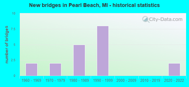
- New bridges - historical statistics
- 21960-1969
- 21970-1979
- 51980-1989
- 81990-1999
- 22020-2022


- Bridge Condition - Deck
- 29.4%Excellent
- 5.9%Very good
- 35.3%Good
- 23.5%Satisfactory
- 5.9%Poor

- Bridge Condition - Superstructure
- 29.4%Excellent
- 17.6%Very good
- 17.6%Good
- 29.4%Satisfactory
- 5.9%Fair

- Bridge Condition - Substructure
- 11.8%Excellent
- 29.4%Very good
- 35.3%Good
- 11.8%Satisfactory
- 11.8%Fair

- Bridge Condition - Channel
- 11.1%Excellent
- 33.3%Very good
- 44.4%Good
- 11.1%Fair
Find on map >> Show street view
Structure Number: 9969, Location: 3 MI SE FAIR HAVEN (Lat: 42.659831, Lng: -82.619614), Route carried "on" structure: State highway 29, Year Built: 1986, Status: Open, Structure Length: 1.50m (4.92ft), Average Daily Traffic: 11,980 (year 2007), Truck Traffic: 2%, Average Future Daily Traffic: 15,817 (year 2018), Design Load: HS 20, Features Intersected: BEAUBIEN CREEK
Minimum Vertical Clearance: 30.48m (100.00ft), Kilometerpoint: 9.013, Lanes on structure: 2, Owner: State Highway Agency, Approaching Roadway Width: 12.8m (42.0ft), Material/Design: Prestressed concrete, Design/Construction: Box Beam or Girders - Multiple, Number Of Spans In Main Unit: 1, Length of Maximum Span: 15.0m (49.2ft), Curb-To-Curb Width: 11.6m (38.1ft), Out-to-Out Width: 12.6m (41.3ft)
Condition: Deck: Good, Superstructure: Very good, Substructure: Fair, Channel: Good, Operating Rating: 82.3 metric tons, Method Used To Determine Operating Rating: Load Factor (LF) rating reported by rating factor (RF) method using MS18 loading, Inventory Rating: 47.3 metric tons, Method Used To Determine Inventory Rating: Load Factor (LF) rating reported by rating factor (RF) method using MS18 loading, Structural Evaluation: Somewhat better than minimum adequacy, Deck Geometry: Somewhat better than minimum adequacy, Waterway Adequacy: Equal to present minimum criteria, Approach Roadway Alignment: Equal to present desirable criteria, Designated Inspection Frequency: Every 24 months, Underwater Inspection Frequency: Every 60 months, Inspection Date: March 2021, Underwater Inspection Date: September 2020, Deck Structure Type: Concrete Cast-file-Place, Wearing Surface/Protective System: Wearing Surface: Epoxy Overlay, Deck Protection: Epoxy Coated Reinforcing
Find on map >> Show street view
Structure Number: 10025, Location: HARSENS ISLAND-CLAY TWP (Lat: 42.576100, Lng: -82.653300), Route carried "on" structure: County highway , Year Built: 1995, Status: Open, Structure Length: 2.31m (7.58ft), Average Daily Traffic: 90 (year 1995), Truck Traffic: 2%, Average Future Daily Traffic: 100 (year 2014), Design Load: HS 20+Mod, Features Intersected: CANOE CUT HIGHWAY CANAL, Facility Carried by Structure: MIDDLE CHANNEL DRV
Minimum Vertical Clearance: 30.48m (100.00ft), Kilometerpoint: 5.511, Lanes on structure: 2, Owner: County Highway Agency, Approaching Roadway Width: 9.1m (29.9ft), Material/Design: Prestressed concrete, Design/Construction: Box Beam or Girders - Multiple, Number Of Spans In Main Unit: 2, Length of Maximum Span: 11.2m (36.7ft), Curb-To-Curb Width: 9.8m (32.2ft), Out-to-Out Width: 10.4m (34.1ft)
Condition: Deck: Good, Superstructure: Good, Substructure: Good, Channel: Very good, Operating Rating: 71.3 metric tons, Method Used To Determine Operating Rating: Load Factor (LF) rating reported by rating factor (RF) method using MS18 loading, Inventory Rating: 42.4 metric tons, Method Used To Determine Inventory Rating: Load Factor (LF) rating reported by rating factor (RF) method using MS18 loading, Structural Evaluation: Better than present minimum criteria, Deck Geometry: Equal to present desirable criteria, Waterway Adequacy: Better than present minimum criteria, Approach Roadway Alignment: Better than present minimum criteria, Designated Inspection Frequency: Every 24 months, Underwater Inspection Frequency: Every 60 months, Inspection Date: May 2020, Underwater Inspection Date: October 2017, Deck Structure Type: Concrete Cast-file-Place, Wearing Surface/Protective System: Wearing Surface: Bituminous
Find on map >> Show street view
Structure Number: 10026, Location: HARSENS ISLAND-CLAY TWP (Lat: 42.586600, Lng: -82.641100), Route carried "on" structure: County highway , Year Built: 1967, Status: Open, Structure Length: 1.46m (4.79ft), Average Daily Traffic: 550 (year 1994), Truck Traffic: 2%, Average Future Daily Traffic: 600 (year 2014), Design Load: HS 20+Mod, Features Intersected: SNOOKS CUT, Facility Carried by Structure: MIDDLE CHANNEL DRV
Minimum Vertical Clearance: 30.48m (100.00ft), Kilometerpoint: 7.447, Lanes on structure: 2, Owner: County Highway Agency, Approaching Roadway Width: 7.3m (24.0ft), Material/Design: Wood or Timber, Design/Construction: Girder and Floorbeam System, Number Of Spans In Main Unit: 3, Length of Maximum Span: 4.8m (15.7ft), Curb or Sidewalk Widths: Left: 1.2m (3.9ft), Right: 1.2m (3.9ft), Curb-To-Curb Width: 8.5m (27.9ft), Out-to-Out Width: 10.9m (35.8ft)
Condition: Deck: Satisfactory, Superstructure: Satisfactory, Substructure: Fair, Channel: Very good, Operating Rating: 97.2 metric tons, Method Used To Determine Operating Rating: Allowable Stress (AS) rating reported by rating factor (RF) method using MS18 loading, Inventory Rating: 88.5 metric tons, Method Used To Determine Inventory Rating: Allowable Stress (AS) rating reported by rating factor (RF) method using MS18 loading, Structural Evaluation: Somewhat better than minimum adequacy, Deck Geometry: Somewhat better than minimum adequacy, Waterway Adequacy: Better than present minimum criteria, Approach Roadway Alignment: Equal to present minimum criteria, Length Of Structure Improvement: 6.10m (20.01ft), Designated Inspection Frequency: Every 24 months, Underwater Inspection Frequency: Every 60 months, Inspection Date: May 2020, Underwater Inspection Date: October 2017, Bridge Improvement Cost: $10,000, Roadway Improvement Cost: $20,000, Total Project Cost: $30,000, Deck Structure Type: Wood or Timber, Wearing Surface/Protective System: Wearing Surface: Wood or Timber
Find on map >> Show street view
Structure Number: 10027, Location: SEC 3 CLAY TWP (Lat: 42.631200, Lng: -82.646100), Route carried "on" structure: County highway , Year Built: 1980, Status: Open, Structure Length: 2.28m (7.48ft), Average Daily Traffic: 1,655 (year 1994), Truck Traffic: 3%, Average Future Daily Traffic: 1,700 (year 2014), Design Load: HS 20+Mod, Features Intersected: UNNAMED CANAL, Facility Carried by Structure: ANCHOR BAY DRIVE
Minimum Vertical Clearance: 30.48m (100.00ft), Kilometerpoint: 2.073, Lanes on structure: 2, Owner: County Highway Agency, Approaching Roadway Width: 6.7m (22.0ft), Material/Design: Prestressed concrete, Design/Construction: Box Beam or Girders - Multiple, Number Of Spans In Main Unit: 3, Length of Maximum Span: 8.2m (26.9ft), Curb-To-Curb Width: 7.3m (24.0ft), Out-to-Out Width: 7.4m (24.3ft)
Condition: Deck: Poor, Superstructure: Fair, Substructure: Satisfactory, Channel: Very good, Operating Rating: 61.9 metric tons, Method Used To Determine Operating Rating: Load Factor (LF) rating reported by rating factor (RF) method using MS18 loading, Inventory Rating: 36.9 metric tons, Method Used To Determine Inventory Rating: Load Factor (LF) rating reported by rating factor (RF) method using MS18 loading, Structural Evaluation: Somewhat better than minimum adequacy, Deck Geometry: Meets minimum limits, Waterway Adequacy: Better than present minimum criteria, Approach Roadway Alignment: Somewhat better than minimum adequacy, Length Of Structure Improvement: 2.29m (7.51ft), Designated Inspection Frequency: Every 12 months, Underwater Inspection Frequency: Every 60 months, Inspection Date: April 2021, Underwater Inspection Date: October 2017, Roadway Improvement Cost: $10,000, Total Project Cost: $12,000, Deck Structure Type: Concrete Cast-file-Place, Wearing Surface/Protective System: Wearing Surface: Bituminous, Membrane: Preformed Fabric
Find on map >> Show street view
Structure Number: 10028, Location: SEC 35 CLAY TWP (Lat: 42.645867, Lng: -82.627042), Route carried "on" structure: County highway , Year Built: 1983, Year Reconstructed: 2019, Status: Open, Structure Length: 1.74m (5.71ft), Average Daily Traffic: 1,655 (year 1994), Truck Traffic: 3%, Average Future Daily Traffic: 1,700 (year 2014), Design Load: Greater than HL93, Features Intersected: UNNAMED CANAL, Facility Carried by Structure: ANCHOR BAY DRIVE
Minimum Vertical Clearance: 30.48m (100.00ft), Kilometerpoint: 1.260, Lanes on structure: 2, Owner: County Highway Agency, Approaching Roadway Width: 6.1m (20.0ft), Material/Design: Steel, Design/Construction: Stringer/Multi-beam, Number Of Spans In Main Unit: 1, Length of Maximum Span: 16.6m (54.5ft), Curb-To-Curb Width: 8.2m (26.9ft), Out-to-Out Width: 8.3m (27.2ft)
Condition: Deck: Excellent, Superstructure: Excellent, Substructure: Good, Channel: Good, Operating Rating: 69.3 metric tons, Method Used To Determine Operating Rating: Load and Resistance Factor Rating (LRFR) rating reported by rating factor(RF) method using HL-93 loadings, Inventory Rating: 53.5 metric tons, Method Used To Determine Inventory Rating: Load and Resistance Factor Rating (LRFR) rating reported by rating factor(RF) method using HL-93 loadings, Structural Evaluation: Better than present minimum criteria, Deck Geometry: Meets minimum limits, Waterway Adequacy: Better than present minimum criteria, Approach Roadway Alignment: Somewhat better than minimum adequacy, Length Of Structure Improvement: 2.29m (7.51ft), Designated Inspection Frequency: Every 24 months, Underwater Inspection Frequency: Every 60 months, Inspection Date: May 2020, Underwater Inspection Date: October 2017, Roadway Improvement Cost: $10,000, Total Project Cost: $12,000, Deck Structure Type: Concrete Precast Panels, Wearing Surface/Protective System: Wearing Surface: Epoxy Overlay, Deck Protection: Epoxy Coated Reinforcing
Find on map >> Show street view
Structure Number: 1003, Location: SEC 25 CLAY TWP (Lat: 42.653467, Lng: -82.622656), Route carried "on" structure: County highway , Year Built: 1984, Year Reconstructed: 2018, Status: Open, Structure Length: 1.74m (5.71ft), Average Daily Traffic: 1,655 (year 1994), Truck Traffic: 3%, Average Future Daily Traffic: 1,700 (year 2014), Design Load: Greater than HL93, Features Intersected: UNNAMED CANAL, Facility Carried by Structure: ANCHOR BAY DRIVE
Minimum Vertical Clearance: 30.48m (100.00ft), Kilometerpoint: 0.340, Lanes on structure: 2, Owner: County Highway Agency, Approaching Roadway Width: 6.1m (20.0ft), Material/Design: Steel, Design/Construction: Stringer/Multi-beam, Number Of Spans In Main Unit: 1, Length of Maximum Span: 16.6m (54.5ft), Curb-To-Curb Width: 8.2m (26.9ft), Out-to-Out Width: 8.3m (27.2ft)
Condition: Deck: Excellent, Superstructure: Excellent, Substructure: Good, Channel: Good, Operating Rating: 73.9 metric tons, Method Used To Determine Operating Rating: Load and Resistance Factor Rating (LRFR) rating reported by rating factor(RF) method using HL-93 loadings, Inventory Rating: 57.0 metric tons, Method Used To Determine Inventory Rating: Load and Resistance Factor Rating (LRFR) rating reported by rating factor(RF) method using HL-93 loadings, Structural Evaluation: Better than present minimum criteria, Deck Geometry: Meets minimum limits, Waterway Adequacy: Better than present minimum criteria, Approach Roadway Alignment: Somewhat better than minimum adequacy, Length Of Structure Improvement: 2.29m (7.51ft), Designated Inspection Frequency: Every 24 months, Underwater Inspection Frequency: Every 60 months, Inspection Date: October 2020, Underwater Inspection Date: October 2017, Roadway Improvement Cost: $10,000, Total Project Cost: $12,000, Deck Structure Type: Concrete Precast Panels, Wearing Surface/Protective System: Wearing Surface: Epoxy Overlay, Deck Protection: Epoxy Coated Reinforcing
Find on map >> Show street view
Structure Number: 10105, Location: SEC. 19-20 COTTRELLVILLE (Lat: 42.673472, Lng: -82.587489), Route carried "on" structure: County highway , Year Built: 2020, Status: Open, Structure Length: 1.51m (4.95ft), Average Daily Traffic: 2,200 (year 2019), Truck Traffic: 13%, Average Future Daily Traffic: 3,270 (year 2039), Design Load: Greater than HL93, Features Intersected: BEAUBIEN CREEK, Facility Carried by Structure: STARVILLE ROAD
Minimum Vertical Clearance: 30.48m (100.00ft), Kilometerpoint: 4.537, Lanes on structure: 2, Owner: County Highway Agency, Approaching Roadway Width: 10.4m (34.1ft), Material/Design: Steel, Design/Construction: Box Beam or Girders - Single/Spread, Number Of Spans In Main Unit: 1, Length of Maximum Span: 14.3m (46.9ft), Curb-To-Curb Width: 10.4m (34.1ft), Out-to-Out Width: 11.3m (37.1ft)
Condition: Deck: Excellent, Superstructure: Excellent, Substructure: Excellent, Channel: Excellent, Operating Rating: 82.9 metric tons, Method Used To Determine Operating Rating: Load and Resistance Factor Rating (LRFR) rating reported by rating factor(RF) method using HL-93 loadings, Inventory Rating: 64.2 metric tons, Method Used To Determine Inventory Rating: Load and Resistance Factor Rating (LRFR) rating reported by rating factor(RF) method using HL-93 loadings, Structural Evaluation: Superior to present desirable criteria, Deck Geometry: Somewhat better than minimum adequacy, Waterway Adequacy: Better than present minimum criteria, Approach Roadway Alignment: Better than present minimum criteria, Length Of Structure Improvement: 5.49m (18.01ft), Designated Inspection Frequency: Every 24 months, Inspection Date: May 2020, Bridge Improvement Cost: $10,000, Roadway Improvement Cost: $14,000, Total Project Cost: $36,000, Deck Structure Type: Concrete Cast-file-Place, Wearing Surface/Protective System: Wearing Surface: Epoxy Overlay, Deck Protection: Epoxy Coated Reinforcing
Find on map >> Show street view
Structure Number: 1014, Location: SEC 1 CLAY TWP (Lat: 42.633147, Lng: -82.616578), Route carried "on" structure: ServiceCounty highway , Year Built: 1990, Status: Open, Structure Length: 1.82m (5.97ft), Average Daily Traffic: 690 (year 1994), Truck Traffic: 3%, Average Future Daily Traffic: 850 (year 2014), Design Load: HS 20, Features Intersected: UNNAMED CANAL, Facility Carried by Structure: AUDUBON DRIVE
Minimum Vertical Clearance: 30.48m (100.00ft), Kilometerpoint: 0.064, Lanes on structure: 2, Owner: County Highway Agency, Approaching Roadway Width: 8.8m (28.9ft), Material/Design: Prestressed concrete, Design/Construction: Box Beam or Girders - Multiple, Number Of Spans In Main Unit: 1, Length of Maximum Span: 17.0m (55.8ft), Curb-To-Curb Width: 8.8m (28.9ft), Out-to-Out Width: 9.4m (30.8ft)
Condition: Deck: Satisfactory, Superstructure: Satisfactory, Substructure: Very good, Channel: Very good, Operating Rating: 86.8 metric tons, Method Used To Determine Operating Rating: Load Factor (LF) rating reported by rating factor (RF) method using MS18 loading, Inventory Rating: 51.8 metric tons, Method Used To Determine Inventory Rating: Load Factor (LF) rating reported by rating factor (RF) method using MS18 loading, Structural Evaluation: Equal to present minimum criteria, Deck Geometry: Somewhat better than minimum adequacy, Waterway Adequacy: Equal to present desirable criteria, Approach Roadway Alignment: Equal to present desirable criteria, Designated Inspection Frequency: Every 24 months, Underwater Inspection Frequency: Every 60 months, Inspection Date: April 2020, Underwater Inspection Date: October 2017, Deck Structure Type: Wood or Timber, Wearing Surface/Protective System: Wearing Surface: Bituminous
Find on map >> Show street view
Structure Number: 10141, Location: SEC 1 CLAY TWP (Lat: 42.634311, Lng: -82.616833), Route carried "on" structure: ServiceCounty highway , Year Built: 1982, Status: Posted for load, Structure Length: 1.89m (6.20ft), Average Daily Traffic: 331 (year 2021), Truck Traffic: 2%, Average Future Daily Traffic: 492 (year 2041), Design Load: H 20, Features Intersected: UNNAMED CANAL, Facility Carried by Structure: BLUEBILL DRIVE
Minimum Vertical Clearance: 30.48m (100.00ft), Kilometerpoint: 0.064, Lanes on structure: 2, Owner: County Highway Agency, Approaching Roadway Width: 7.9m (25.9ft), Material/Design: Prestressed concrete, Design/Construction: Box Beam or Girders - Multiple, Number Of Spans In Main Unit: 1, Length of Maximum Span: 18.6m (61.0ft), Curb-To-Curb Width: 7.3m (24.0ft), Out-to-Out Width: 7.4m (24.3ft)
Condition: Deck: Good, Superstructure: Satisfactory, Substructure: Good, Channel: Very good, Operating Rating: 65.1 metric tons, Method Used To Determine Operating Rating: Load Factor (LF) rating reported by rating factor (RF) method using MS18 loading, Inventory Rating: 38.9 metric tons, Method Used To Determine Inventory Rating: Load Factor (LF) rating reported by rating factor (RF) method using MS18 loading, Structural Evaluation: Equal to present minimum criteria, Deck Geometry: Somewhat better than minimum adequacy, Waterway Adequacy: Better than present minimum criteria, Approach Roadway Alignment: Equal to present minimum criteria, Bridge Posting: Required (Relationship of Operating Rating to Maximum Legal Load: 0.1 - 9.9% below), Length Of Structure Improvement: 2.29m (7.51ft), Designated Inspection Frequency: Every 24 months, Underwater Inspection Frequency: Every 60 months, Inspection Date: April 2020, Underwater Inspection Date: October 2017, Roadway Improvement Cost: $10,000, Total Project Cost: $12,000, Deck Structure Type: Concrete Cast-file-Place, Wearing Surface/Protective System: Wearing Surface: Bituminous
Find on map >> Show street view
Structure Number: 10142, Location: SEC 1 CLAY TWP (Lat: 42.635539, Lng: -82.617000), Route carried "on" structure: ServiceCounty highway , Year Built: 1990, Status: Open, Structure Length: 1.82m (5.97ft), Average Daily Traffic: 675 (year 1994), Truck Traffic: 3%, Average Future Daily Traffic: 830 (year 2014), Design Load: HS 20, Features Intersected: UNNAMED CANAL, Facility Carried by Structure: CARDINAL DRIVE
Minimum Vertical Clearance: 30.48m (100.00ft), Kilometerpoint: 0.064, Lanes on structure: 2, Owner: County Highway Agency, Approaching Roadway Width: 8.8m (28.9ft), Material/Design: Prestressed concrete, Design/Construction: Box Beam or Girders - Multiple, Number Of Spans In Main Unit: 1, Length of Maximum Span: 17.0m (55.8ft), Curb-To-Curb Width: 8.8m (28.9ft), Out-to-Out Width: 9.4m (30.8ft)
Condition: Deck: Good, Superstructure: Good, Substructure: Very good, Channel: Very good, Operating Rating: 86.8 metric tons, Method Used To Determine Operating Rating: Load Factor (LF) rating reported by rating factor (RF) method using MS18 loading, Inventory Rating: 51.8 metric tons, Method Used To Determine Inventory Rating: Load Factor (LF) rating reported by rating factor (RF) method using MS18 loading, Structural Evaluation: Better than present minimum criteria, Deck Geometry: Somewhat better than minimum adequacy, Waterway Adequacy: Equal to present desirable criteria, Approach Roadway Alignment: Somewhat better than minimum adequacy, Designated Inspection Frequency: Every 24 months, Underwater Inspection Frequency: Every 60 months, Inspection Date: April 2020, Underwater Inspection Date: October 2017, Deck Structure Type: Wood or Timber, Wearing Surface/Protective System: Wearing Surface: Bituminous
Find on map >> Show street view
Structure Number: 10143, Location: SEC 36 CLAY TWP (Lat: 42.636764, Lng: -82.617147), Route carried "on" structure: ServiceCounty highway , Year Built: 2021, Status: Open, Structure Length: 2.13m (6.99ft), Average Daily Traffic: 569 (year 2020), Truck Traffic: 7%, Average Future Daily Traffic: 694 (year 2040), Design Load: Greater than HL93, Features Intersected: UNNAMED CANAL, Facility Carried by Structure: FLAMINGO DRIVE
Minimum Vertical Clearance: 30.48m (100.00ft), Kilometerpoint: 0.061, Lanes on structure: 2, Owner: County Highway Agency, Approaching Roadway Width: 8.3m (27.2ft), Material/Design: Wood or Timber, Design/Construction: Slab, Number Of Spans In Main Unit: 3, Length of Maximum Span: 7.9m (25.9ft), Curb or Sidewalk Widths: Left: 0.3m (1.0ft), Right: 0.3m (1.0ft), Curb-To-Curb Width: 7.9m (25.9ft), Out-to-Out Width: 8.5m (27.9ft)
Condition: Deck: Excellent, Superstructure: Excellent, Substructure: Excellent, Channel: Excellent, Operating Rating: 70.3 metric tons, Method Used To Determine Operating Rating: Load and Resistance Factor Rating (LRFR) rating reported by rating factor(RF) method using HL-93 loadings, Inventory Rating: 54.4 metric tons, Method Used To Determine Inventory Rating: Load and Resistance Factor Rating (LRFR) rating reported by rating factor(RF) method using HL-93 loadings, Structural Evaluation: Superior to present desirable criteria, Deck Geometry: Somewhat better than minimum adequacy, Waterway Adequacy: Equal to present desirable criteria, Approach Roadway Alignment: Equal to present minimum criteria, Length Of Structure Improvement: 6.00m (19.69ft), Designated Inspection Frequency: Every 24 months, Underwater Inspection Frequency: Every 60 months, Inspection Date: Febuary 2022, Underwater Inspection Date: October 2017, Bridge Improvement Cost: $895,000,000, Roadway Improvement Cost: $191,000,000, Total Project Cost: $108,600,000 ( Estimate for 2016), Deck Structure Type: Wood or Timber, Wearing Surface/Protective System: Wearing Surface: Bituminous
Find on map >> Show street view
Structure Number: 10144, Location: SEC 1 CLAY TWP (Lat: 42.629017, Lng: -82.611717), Route carried "on" structure: ServiceCounty highway , Year Built: 1968, Year Reconstructed: 2017, Status: Open, Structure Length: 0.77m (2.53ft), Average Daily Traffic: 1,003 (year 2016), Truck Traffic: 7%, Average Future Daily Traffic: 1,225 (year 2036), Design Load: Greater than HL93, Features Intersected: UNNAMED CANAL, Facility Carried by Structure: MERRILL DRIVE
Minimum Vertical Clearance: 30+ m (98+ ft), Kilometerpoint: 0.076, Lanes on structure: 2, Owner: County Highway Agency, Approaching Roadway Width: 8.5m (27.9ft), Material/Design: Wood or Timber, Design/Construction: Slab, Number Of Spans In Main Unit: 1, Length of Maximum Span: 6.1m (20.0ft), Curb or Sidewalk Widths: Left: 0.3m (1.0ft), Right: 0.3m (1.0ft), Curb-To-Curb Width: 8.5m (27.9ft), Out-to-Out Width: 9.1m (29.9ft)
Condition: Deck: Excellent, Superstructure: Excellent, Substructure: Good, Channel: Good, Operating Rating: 80.0 metric tons, Method Used To Determine Operating Rating: Load and Resistance Factor Rating (LRFR) rating reported by rating factor(RF) method using HL-93 loadings, Inventory Rating: 61.6 metric tons, Method Used To Determine Inventory Rating: Load and Resistance Factor Rating (LRFR) rating reported by rating factor(RF) method using HL-93 loadings, Structural Evaluation: Better than present minimum criteria, Deck Geometry: Somewhat better than minimum adequacy, Waterway Adequacy: Better than present minimum criteria, Approach Roadway Alignment: Better than present minimum criteria, Designated Inspection Frequency: Every 24 months, Underwater Inspection Frequency: Every 60 months, Inspection Date: August 2021, Underwater Inspection Date: October 2017, Deck Structure Type: Wood or Timber, Wearing Surface/Protective System: Wearing Surface: Bituminous, Membrane: Preformed Fabric
Find on map >> Show street view
Structure Number: 10145, Location: PC 198-309 CLAY TWP (Lat: 42.645900, Lng: -82.589200), Route carried "on" structure: ServiceCounty highway , Year Built: 1996, Status: Open, Structure Length: 0.61m (2.00ft), Average Daily Traffic: 465 (year 1997), Truck Traffic: 2%, Average Future Daily Traffic: 1,230 (year 2017), Design Load: HS 20, Features Intersected: SWARTOUT DRAIN, Facility Carried by Structure: PHELPS ROAD
Minimum Vertical Clearance: 30.48m (100.00ft), Kilometerpoint: 3.019, Lanes on structure: 2, Owner: County Highway Agency, Approaching Roadway Width: 8.5m (27.9ft), Skew: 3 degrees, Material/Design: Steel, Design/Construction: Culvert, Number Of Spans In Main Unit: 2, Length of Maximum Span: 2.1m (6.9ft), Curb-To-Curb Width: 8.5m (27.9ft), Out-to-Out Width: 26.2m (86.0ft)
Condition: Channel: Fair, Culverts: Good, Operating Rating: 93.6 metric tons, Method Used To Determine Operating Rating: Load Factor (LF) rating reported by rating factor (RF) method using MS18 loading, Inventory Rating: 56.1 metric tons, Method Used To Determine Inventory Rating: Load Factor (LF) rating reported by rating factor (RF) method using MS18 loading, Structural Evaluation: Better than present minimum criteria, Deck Geometry: Somewhat better than minimum adequacy, Waterway Adequacy: Better than present minimum criteria, Approach Roadway Alignment: Better than present minimum criteria, Designated Inspection Frequency: Every 24 months, Inspection Date: April 2020, Wearing Surface/Protective System: Wearing Surface: Bituminous
Find on map >> Show street view
Structure Number: 10157, Location: SEC. 18 COTTRELLVILLE TWP (Lat: 42.688392, Lng: -82.589250), Route carried "on" structure: ServiceCounty highway , Year Built: 1972, Status: Open, Structure Length: 0.91m (2.99ft), Average Daily Traffic: 290 (year 1994), Truck Traffic: 3%, Average Future Daily Traffic: 360 (year 2014), Design Load: HS 20, Features Intersected: BEAUBIEN CREEK DRAIN, Facility Carried by Structure: BROADBRIDGE ROAD
Minimum Vertical Clearance: 30.48m (100.00ft), Kilometerpoint: 4.905, Lanes on structure: 2, Owner: County Highway Agency, Approaching Roadway Width: 6.1m (20.0ft), Material/Design: Wood or Timber, Design/Construction: Slab, Number Of Spans In Main Unit: 1, Length of Maximum Span: 8.5m (27.9ft), Curb-To-Curb Width: 10.1m (33.1ft), Out-to-Out Width: 10.4m (34.1ft)
Condition: Deck: Satisfactory, Superstructure: Satisfactory, Substructure: Good, Channel: Fair, Operating Rating: 72.6 metric tons, Method Used To Determine Operating Rating: Load Factor (LF) rating reported by rating factor (RF) method using MS18 loading, Inventory Rating: 52.2 metric tons, Method Used To Determine Inventory Rating: Load Factor (LF) rating reported by rating factor (RF) method using MS18 loading, Structural Evaluation: Equal to present minimum criteria, Deck Geometry: Better than present minimum criteria, Waterway Adequacy: Equal to present minimum criteria, Approach Roadway Alignment: Equal to present minimum criteria, Length Of Structure Improvement: 5.49m (18.01ft), Designated Inspection Frequency: Every 24 months, Inspection Date: April 2020, Roadway Improvement Cost: $19,000, Total Project Cost: $20,000, Deck Structure Type: Wood or Timber, Wearing Surface/Protective System: Wearing Surface: Wood or Timber
Find on map >> Show street view
Structure Number: 10189, Location: SEC. 22 IRA TWP. (Lat: 42.677725, Lng: -82.658031), Route carried "on" structure: ServiceCounty highway , Year Built: 1977, Status: Open, Structure Length: 1.03m (3.38ft), Average Daily Traffic: 126 (year 1994), Truck Traffic: 3%, Average Future Daily Traffic: 205 (year 2014), Design Load: HS 20+Mod, Features Intersected: UNNAMED CANAL, Facility Carried by Structure: WATERWORKS DRIVE
Minimum Vertical Clearance: 30.48m (100.00ft), Kilometerpoint: 0.021, Lanes on structure: 2, Owner: County Highway Agency, Approaching Roadway Width: 6.1m (20.0ft), Material/Design: Wood or Timber, Design/Construction: Slab, Number Of Spans In Main Unit: 1, Length of Maximum Span: 9.7m (31.8ft), Curb-To-Curb Width: 6.1m (20.0ft), Out-to-Out Width: 6.6m (21.7ft)
Condition: Deck: Satisfactory, Superstructure: Satisfactory, Substructure: Satisfactory, Channel: Good, Operating Rating: 50.2 metric tons, Method Used To Determine Operating Rating: Load Factor (LF) rating reported by rating factor (RF) method using MS18 loading, Inventory Rating: 35.0 metric tons, Method Used To Determine Inventory Rating: Load Factor (LF) rating reported by rating factor (RF) method using MS18 loading, Structural Evaluation: Equal to present minimum criteria, Deck Geometry: Meets minimum limits, Waterway Adequacy: Equal to present minimum criteria, Approach Roadway Alignment: Somewhat better than minimum adequacy, Designated Inspection Frequency: Every 24 months, Underwater Inspection Frequency: Every 60 months, Inspection Date: March 2020, Underwater Inspection Date: October 2017, Deck Structure Type: Wood or Timber, Wearing Surface/Protective System: Wearing Surface: Wood or Timber
Find on map >> Show street view
Structure Number: 13605, Location: 100FT W OF VAN DYKE (Lat: 42.632167, Lng: -82.616056), Route carried "on" structure: ServiceCounty highway , Year Built: 1995, Status: Open, Structure Length: 1.01m (3.31ft), Average Daily Traffic: 500 (year 1994), Truck Traffic: 3%, Average Future Daily Traffic: 520 (year 2004), Design Load: HS 20, Features Intersected: UNNAMED CANAL, Facility Carried by Structure: COLONY DRIVE
Minimum Vertical Clearance: 30.48m (100.00ft), Kilometerpoint: 2.514, Lanes on structure: 2, Owner: County Highway Agency, Approaching Roadway Width: 6.7m (22.0ft), Material/Design: Prestressed concrete, Design/Construction: Channel Beam, Number Of Spans In Main Unit: 1, Length of Maximum Span: 9.8m (32.2ft), Curb or Sidewalk Widths: Left: 0.3m (1.0ft), Right: 0.3m (1.0ft), Curb-To-Curb Width: 6.7m (22.0ft), Out-to-Out Width: 7.3m (24.0ft)
Condition: Deck: Good, Superstructure: Very good, Substructure: Very good, Channel: Good, Operating Rating: 63.2 metric tons, Method Used To Determine Operating Rating: Load Factor (LF) rating reported by rating factor (RF) method using MS18 loading, Inventory Rating: 37.9 metric tons, Method Used To Determine Inventory Rating: Load Factor (LF) rating reported by rating factor (RF) method using MS18 loading, Structural Evaluation: Equal to present desirable criteria, Deck Geometry: Meets minimum limits, Waterway Adequacy: Better than present minimum criteria, Approach Roadway Alignment: Equal to present minimum criteria, Designated Inspection Frequency: Every 24 months, Underwater Inspection Frequency: Every 60 months, Inspection Date: May 2020, Underwater Inspection Date: October 2017, Deck Structure Type: Concrete Precast Panels, Wearing Surface/Protective System: Wearing Surface: Bituminous, Membrane: Preformed Fabric
Find on map >> Show street view
Structure Number: 13606, Location: 0.7 MI W OF VAN DYKE (Lat: 42.631333, Lng: -82.628167), Route carried "on" structure: ServiceCounty highway , Year Built: 1995, Status: Open, Structure Length: 0.80m (2.62ft), Average Daily Traffic: 500 (year 1994), Truck Traffic: 3%, Average Future Daily Traffic: 520 (year 2004), Design Load: HS 20, Features Intersected: UNNAMED CANAL, Facility Carried by Structure: COLONY DRIVE
Minimum Vertical Clearance: 30.48m (100.00ft), Kilometerpoint: 1.355, Lanes on structure: 2, Owner: County Highway Agency, Approaching Roadway Width: 6.7m (22.0ft), Material/Design: Prestressed concrete, Design/Construction: Channel Beam, Number Of Spans In Main Unit: 1, Length of Maximum Span: 7.6m (24.9ft), Curb or Sidewalk Widths: Left: 0.3m (1.0ft), Right: 0.3m (1.0ft), Curb-To-Curb Width: 6.7m (22.0ft), Out-to-Out Width: 7.3m (24.0ft)
Condition: Deck: Very good, Superstructure: Very good, Substructure: Very good, Channel: Good, Operating Rating: 69.3 metric tons, Method Used To Determine Operating Rating: Load Factor (LF) rating reported by rating factor (RF) method using MS18 loading, Inventory Rating: 41.5 metric tons, Method Used To Determine Inventory Rating: Load Factor (LF) rating reported by rating factor (RF) method using MS18 loading, Structural Evaluation: Equal to present desirable criteria, Deck Geometry: Meets minimum limits, Waterway Adequacy: Better than present minimum criteria, Approach Roadway Alignment: Equal to present minimum criteria, Designated Inspection Frequency: Every 24 months, Underwater Inspection Frequency: Every 60 months, Inspection Date: May 2020, Underwater Inspection Date: October 2017, Deck Structure Type: Concrete Precast Panels, Wearing Surface/Protective System: Wearing Surface: Bituminous, Deck Protection: Epoxy Coated Reinforcing
Find on map >> Show street view
Structure Number: 13607, Location: 1.1 MI W OVF VAN DYKE (Lat: 42.632722, Lng: -82.634056), Route carried "on" structure: ServiceCounty highway , Year Built: 1995, Status: Open, Structure Length: 0.89m (2.92ft), Average Daily Traffic: 500 (year 1994), Truck Traffic: 3%, Average Future Daily Traffic: 520 (year 2004), Design Load: HS 20, Features Intersected: UNNAMED CANAL, Facility Carried by Structure: COLONY DRIVE
Minimum Vertical Clearance: 30.48m (100.00ft), Kilometerpoint: 0.837, Lanes on structure: 2, Owner: County Highway Agency, Approaching Roadway Width: 6.7m (22.0ft), Material/Design: Prestressed concrete, Design/Construction: Channel Beam, Number Of Spans In Main Unit: 1, Length of Maximum Span: 8.5m (27.9ft), Curb or Sidewalk Widths: Left: 0.3m (1.0ft), Right: 0.3m (1.0ft), Curb-To-Curb Width: 6.7m (22.0ft), Out-to-Out Width: 7.3m (24.0ft)
Condition: Deck: Good, Superstructure: Good, Substructure: Very good, Channel: Good, Operating Rating: 70.6 metric tons, Method Used To Determine Operating Rating: Load Factor (LF) rating reported by rating factor (RF) method using MS18 loading, Inventory Rating: 42.1 metric tons, Method Used To Determine Inventory Rating: Load Factor (LF) rating reported by rating factor (RF) method using MS18 loading, Structural Evaluation: Better than present minimum criteria, Deck Geometry: Meets minimum limits, Waterway Adequacy: Better than present minimum criteria, Approach Roadway Alignment: Equal to present minimum criteria, Designated Inspection Frequency: Every 24 months, Underwater Inspection Frequency: Every 60 months, Inspection Date: May 2020, Underwater Inspection Date: October 2017, Deck Structure Type: Concrete Precast Panels, Wearing Surface/Protective System: Wearing Surface: Bituminous, Membrane: Preformed Fabric
Find on map >> Show street view
Structure Number: 14029, Location: 0.25 MI SE OF PALMS RD (Lat: 42.673231, Lng: -82.624131), Route carried "under" structure: State highway 29, Year Built: 1991, Structure Length: 0. m, Average Daily Traffic: 10,668 (year 2015), Truck Traffic: 2%, Features Intersected: M-29, Facility Carried by Structure: BOUVIER MARINA PED
Minimum Vertical Clearance: 5.33m (17.49ft), Kilometerpoint: 7.413, Lanes under structure: 2, Material/Design: Steel, Design/Construction: Truss - Thru, Length of Maximum Span: 38.1m (125.0ft)