Bridge Statistics for Ocala, Florida (FL)
Condition, Traffic, Stress, Structural Evaluation, Project Costs
- National Bridge Inventory (NBI) Statistics
- 47Number of bridges
- 531ft / 162mTotal length
- $56,000Total costs
- 1,274,445Total average daily traffic
- 197,037Total average daily truck traffic
- National Bridge Inventory (NBI) Registered Bridges for Ocala
- No street view available for this location
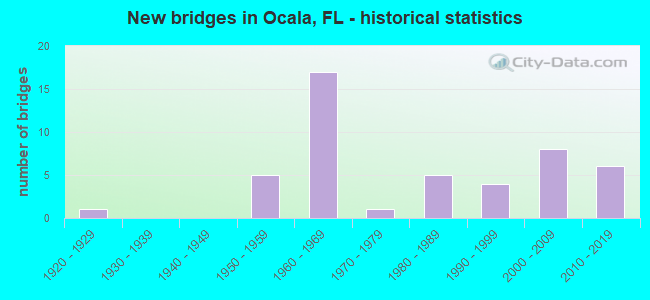
- New bridges - historical statistics
- 11920-1929
- 51950-1959
- 171960-1969
- 11970-1979
- 51980-1989
- 41990-1999
- 82000-2009
- 62010-2019
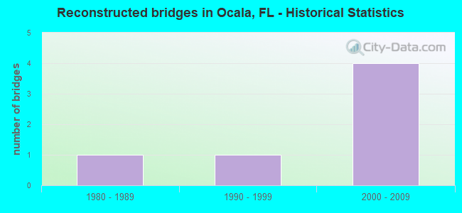
- Reconstructed bridges - Historical Statistics
- 11980-1989
- 11990-1999
- 42000-2009
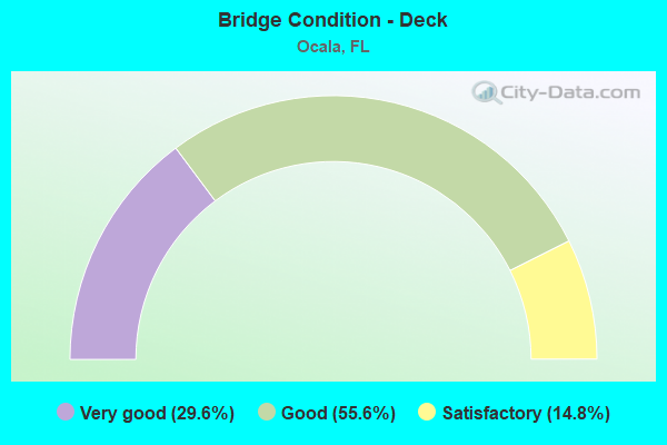
- Bridge Condition - Deck
- 29.6%Very good
- 55.6%Good
- 14.8%Satisfactory
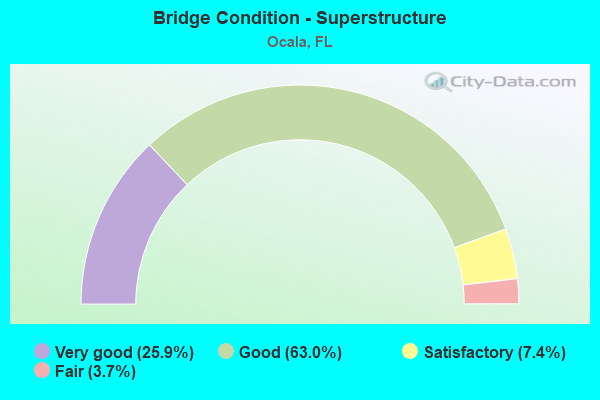
- Bridge Condition - Superstructure
- 25.9%Very good
- 63.0%Good
- 7.4%Satisfactory
- 3.7%Fair
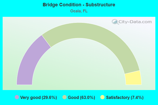
- Bridge Condition - Substructure
- 29.6%Very good
- 63.0%Good
- 7.4%Satisfactory
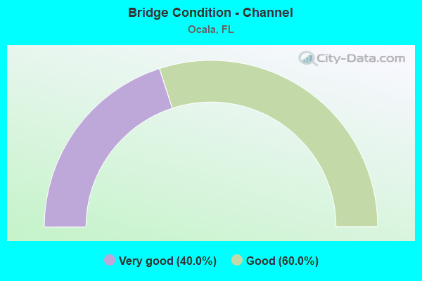
- Bridge Condition - Channel
- 40.0%Very good
- 60.0%Good
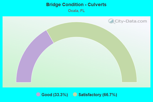
- Bridge Condition - Culverts
- 33.3%Good
- 66.7%Satisfactory
Find on map >> Show street view
Structure Number: 300061, Location: FANNING SPRINGS (Lat: 29.591233, Lng: -82.937503), Route carried "on" structure: US 19, Year Built: 1987, Status: Open, Structure Length: 24.57m (80.61ft), Average Daily Traffic: 6,300 (year 2020), Truck Traffic: 19%, Average Future Daily Traffic: 10,930 (year 2042), Design Load: HS 20+Mod, Features Intersected: SUWANNEE RIVER
Minimum Vertical Clearance: 30+ m (98+ ft), Kilometerpoint: 46.769, Lanes on structure: 2, Base Highway Network: Yes, Owner: State Highway Agency, Approaching Roadway Width: 8.1m (26.6ft), Navigation Control: Yes ( Vertical Clearance: 0.3m (1.0ft), Horizontal Clearance: 0.3m (1.0ft)), Material/Design: Prestressed concrete, Design/Construction: Stringer/Multi-beam, Number Of Spans In Main Unit: 9, Length of Maximum Span: 36.9m (121.1ft), Curb-To-Curb Width: 12.2m (40.0ft), Out-to-Out Width: 13.0m (42.7ft)
Condition: Deck: Good, Superstructure: Satisfactory, Substructure: Satisfactory, Channel: Good, Operating Rating: 57.6 metric tons, Method Used To Determine Operating Rating: Load Factor (LF), Inventory Rating: 32.2 metric tons, Method Used To Determine Inventory Rating: Load Factor (LF), Structural Evaluation: Equal to present minimum criteria, Deck Geometry: Better than present minimum criteria, Waterway Adequacy: Equal to present desirable criteria, Approach Roadway Alignment: Equal to present desirable criteria, Designated Inspection Frequency: Every 24 months, Underwater Inspection Frequency: Every 23 months, Inspection Date: April 2021, Underwater Inspection Date: April 2021, Deck Structure Type: Concrete Cast-file-Place
Find on map >> Show street view
Structure Number: 360018, Location: I-75 SB over SR-40 (Lat: 29.186317, Lng: -82.184842), Route carried "on" structure: Interstate 75, Year Built: 1964, Year Reconstructed: 1995, Status: Open, Structure Length: 5.88m (19.29ft), Average Daily Traffic: 45,750 (year 2020), Truck Traffic: 21%, Average Future Daily Traffic: 79,377 (year 2042), Design Load: HS 20+Mod, Features Intersected: SR-40
Minimum Vertical Clearance: 30+ m (98+ ft), Kilometerpoint: 26.413, Lanes on structure: 3, Lanes under structure: 5, Base Highway Network: Yes, Owner: State Highway Agency, Approaching Roadway Width: 16.6m (54.5ft), Material/Design: Prestressed concrete, Design/Construction: Stringer/Multi-beam, Number Of Spans In Main Unit: 3, Length of Maximum Span: 24.1m (79.1ft), Curb-To-Curb Width: 17.2m (56.4ft), Out-to-Out Width: 18.1m (59.4ft)
Condition: Deck: Good, Superstructure: Good, Substructure: Good, Operating Rating: 54.3 metric tons, Method Used To Determine Operating Rating: Load Factor (LF), Inventory Rating: 32.6 metric tons, Method Used To Determine Inventory Rating: Load Factor (LF), Structural Evaluation: Better than present minimum criteria, Deck Geometry: Better than present minimum criteria, Underclear: High priority of corrective action, Approach Roadway Alignment: Equal to present desirable criteria, Designated Inspection Frequency: Every 24 months, Inspection Date: April 2021, Deck Structure Type: Concrete Cast-file-Place
Find on map >> Show street view
Structure Number: 360019, Location: 1 Mi. E of CR-35 (Lat: 29.219319, Lng: -82.042422), Route carried "on" structure: State highway 40, Year Built: 1958, Status: Open, Structure Length: 0.98m (3.22ft), Average Daily Traffic: 12,800 (year 2020), Truck Traffic: 7%, Average Future Daily Traffic: 22,208 (year 2042), Design Load: H 20, Features Intersected: Creek
Minimum Vertical Clearance: 30+ m (98+ ft), Kilometerpoint: 10.733, Lanes on structure: 2, Base Highway Network: Yes, Owner: State Highway Agency, Approaching Roadway Width: 9.7m (31.8ft), Material/Design: Concrete, Design/Construction: Culvert, Number Of Spans In Main Unit: 3, Length of Maximum Span: 3.0m (9.8ft)
Condition: Channel: Good, Culverts: Satisfactory, Operating Rating: 54.4 metric tons, Method Used To Determine Operating Rating: Load Testing, Inventory Rating: 32.7 metric tons, Method Used To Determine Inventory Rating: Load Testing, Structural Evaluation: Equal to present minimum criteria, Waterway Adequacy: Equal to present desirable criteria, Approach Roadway Alignment: Equal to present desirable criteria, Length Of Structure Improvement: 1.71m (5.61ft), Designated Inspection Frequency: Every 24 months, Inspection Date: September 2021, Bridge Improvement Cost: $42,000, Total Project Cost: $56,000
Find on map >> Show street view
Structure Number: 360022, Location: I-75 SB over US-27 (Lat: 29.206456, Lng: -82.184681), Route carried "on" structure: Interstate 75, Year Built: 1964, Year Reconstructed: 2000, Status: Open, Structure Length: 5.77m (18.93ft), Average Daily Traffic: 39,000 (year 2020), Truck Traffic: 22%, Average Future Daily Traffic: 67,665 (year 2042), Design Load: HS 20+Mod, Features Intersected: US-27
Minimum Vertical Clearance: 30.18m (99.02ft), Kilometerpoint: 28.637, Lanes on structure: 3, Lanes under structure: 6, Base Highway Network: Yes, Owner: State Highway Agency, Approaching Roadway Width: 17.1m (56.1ft), Skew: 2 degrees, Material/Design: Prestressed concrete, Design/Construction: Stringer/Multi-beam, Number Of Spans In Main Unit: 4, Length of Maximum Span: 16.2m (53.1ft), Curb-To-Curb Width: 17.1m (56.1ft), Out-to-Out Width: 18.1m (59.4ft)
Condition: Deck: Good, Superstructure: Fair, Substructure: Good, Operating Rating: 52.3 metric tons, Method Used To Determine Operating Rating: Load Factor (LF), Inventory Rating: 31.4 metric tons, Method Used To Determine Inventory Rating: Load Factor (LF), Structural Evaluation: Somewhat better than minimum adequacy, Deck Geometry: Equal to present minimum criteria, Underclear: High priority of corrective action, Approach Roadway Alignment: Equal to present desirable criteria, Designated Inspection Frequency: Every 24 months, Inspection Date: May 2021, Deck Structure Type: Concrete Cast-file-Place
Find on map >> Show street view
Structure Number: 360023, Location: I-75 NB over US-27 (Lat: 29.206322, Lng: -82.184433), Route carried "on" structure: Interstate 75, Year Built: 1964, Year Reconstructed: 2000, Status: Open, Structure Length: 5.77m (18.93ft), Average Daily Traffic: 78,000 (year 2020), Truck Traffic: 22%, Average Future Daily Traffic: 67,665 (year 2042), Design Load: HS 20+Mod, Features Intersected: US-27
Minimum Vertical Clearance: 30+ m (98+ ft), Kilometerpoint: 28.637, Lanes on structure: 3, Lanes under structure: 6, Base Highway Network: Yes, Owner: State Highway Agency, Approaching Roadway Width: 17.1m (56.1ft), Skew: 2 degrees, Material/Design: Prestressed concrete, Design/Construction: Stringer/Multi-beam, Number Of Spans In Main Unit: 4, Length of Maximum Span: 16.2m (53.1ft), Curb-To-Curb Width: 17.1m (56.1ft), Out-to-Out Width: 18.1m (59.4ft)
Condition: Deck: Good, Superstructure: Good, Substructure: Good, Operating Rating: 52.3 metric tons, Method Used To Determine Operating Rating: Load Factor (LF), Inventory Rating: 31.4 metric tons, Method Used To Determine Inventory Rating: Load Factor (LF), Structural Evaluation: Better than present minimum criteria, Deck Geometry: Equal to present minimum criteria, Underclear: High priority of corrective action, Approach Roadway Alignment: Equal to present desirable criteria, Designated Inspection Frequency: Every 24 months, Inspection Date: May 2021, Deck Structure Type: Concrete Cast-file-Place
Find on map >> Show street view
Structure Number: 360024, Location: I-75 SB over SR-326 (Lat: 29.266958, Lng: -82.193247), Route carried "on" structure: Interstate 75, Year Built: 1964, Year Reconstructed: 2000, Status: Open, Structure Length: 5.12m (16.80ft), Average Daily Traffic: 34,750 (year 2020), Truck Traffic: 28%, Average Future Daily Traffic: 60,291 (year 2042), Design Load: HS 20+Mod, Features Intersected: SR-326
Minimum Vertical Clearance: 30+ m (98+ ft), Kilometerpoint: 35.529, Lanes on structure: 4, Lanes under structure: 5, Base Highway Network: Yes, Owner: State Highway Agency, Approaching Roadway Width: 19.6m (64.3ft), Skew: 1 degrees, Material/Design: Prestressed concrete, Design/Construction: Stringer/Multi-beam, Number Of Spans In Main Unit: 3, Length of Maximum Span: 17.1m (56.1ft), Curb-To-Curb Width: 19.6m (64.3ft), Out-to-Out Width: 20.4m (66.9ft)
Condition: Deck: Good, Superstructure: Good, Substructure: Good, Operating Rating: 63.4 metric tons, Method Used To Determine Operating Rating: Load Factor (LF), Inventory Rating: 38.0 metric tons, Method Used To Determine Inventory Rating: Load Factor (LF), Structural Evaluation: Better than present minimum criteria, Deck Geometry: Somewhat better than minimum adequacy, Underclear: High priority of corrective action, Approach Roadway Alignment: Equal to present desirable criteria, Designated Inspection Frequency: Every 24 months, Inspection Date: May 2021, Deck Structure Type: Concrete Cast-file-Place
Find on map >> Show street view
Structure Number: 360025, Location: US-441 over SCLRR (Lat: 29.191600, Lng: -82.140831), Route carried "on" structure: US 27, Year Built: 1951, Status: Open, Structure Length: 9.20m (30.18ft), Average Daily Traffic: 28,000 (year 2020), Truck Traffic: 12%, Average Future Daily Traffic: 48,580 (year 2042), Design Load: H 20, Features Intersected: SCLRR
Minimum Vertical Clearance: 30+ m (98+ ft), Kilometerpoint: 1.326, Lanes on structure: 4, Base Highway Network: Yes, Owner: State Highway Agency, Approaching Roadway Width: 19.2m (63.0ft), Skew: 31 degrees, Material/Design: Steel, Design/Construction: Stringer/Multi-beam, Number Of Spans In Main Unit: 5, Length of Maximum Span: 18.3m (60.0ft), Curb-To-Curb Width: 19.2m (63.0ft), Out-to-Out Width: 21.4m (70.2ft)
Condition: Deck: Good, Superstructure: Satisfactory, Substructure: Good, Operating Rating: 87.2 metric tons, Method Used To Determine Operating Rating: Load Factor (LF), Inventory Rating: 52.3 metric tons, Method Used To Determine Inventory Rating: Load Factor (LF), Structural Evaluation: Equal to present minimum criteria, Deck Geometry: Equal to present minimum criteria, Underclear: Equal to present minimum criteria, Approach Roadway Alignment: Equal to present desirable criteria, Designated Inspection Frequency: Every 24 months, Inspection Date: September 2021, Deck Structure Type: Concrete Cast-file-Place, Wearing Surface/Protective System: Wearing Surface: Monolithic Concrete, Membrane: Epoxy, Deck Protection: Bituminous
Find on map >> Show street view
Structure Number: 360026, Location: US-441-NW8th Ave SCLRR (Lat: 29.202044, Lng: -82.141933), Route carried "on" structure: US 301, Year Built: 1951, Status: Open, Structure Length: 8.47m (27.79ft), Average Daily Traffic: 27,000 (year 2020), Truck Traffic: 9%, Average Future Daily Traffic: 46,845 (year 2042), Design Load: H 20, Features Intersected: NW 8th Ave-SCLRR
Minimum Vertical Clearance: 30+ m (98+ ft), Kilometerpoint: 2.494, Lanes on structure: 4, Lanes under structure: 2, Base Highway Network: Yes, Owner: State Highway Agency, Approaching Roadway Width: 20.6m (67.6ft), Skew: 32 degrees, Material/Design: Steel continuous, Design/Construction: Stringer/Multi-beam, Number Of Spans In Main Unit: 4, Length of Maximum Span: 23.8m (78.1ft), Curb-To-Curb Width: 19.5m (64.0ft), Out-to-Out Width: 21.8m (71.5ft)
Condition: Deck: Satisfactory, Superstructure: Good, Substructure: Good, Operating Rating: 78.3 metric tons, Method Used To Determine Operating Rating: Load Factor (LF), Inventory Rating: 47.0 metric tons, Method Used To Determine Inventory Rating: Load Factor (LF), Structural Evaluation: Better than present minimum criteria, Deck Geometry: Better than present minimum criteria, Underclear: High priority of corrective action, Approach Roadway Alignment: Equal to present desirable criteria, Designated Inspection Frequency: Every 24 months, Inspection Date: September 2021, Deck Structure Type: Concrete Cast-file-Place, Wearing Surface/Protective System: Wearing Surface: Monolithic Concrete, Membrane: Epoxy, Deck Protection: Bituminous
Find on map >> Show street view
Structure Number: 360043, Location: I-75 NB over SR-326 (Lat: 29.266944, Lng: -82.192956), Route carried "on" structure: Interstate 75, Year Built: 1964, Year Reconstructed: 2000, Status: Open, Structure Length: 5.12m (16.80ft), Average Daily Traffic: 34,750 (year 2020), Truck Traffic: 28%, Average Future Daily Traffic: 60,291 (year 2042), Design Load: HS 20+Mod, Features Intersected: SR-326
Minimum Vertical Clearance: 30+ m (98+ ft), Kilometerpoint: 35.520, Lanes on structure: 3, Lanes under structure: 5, Base Highway Network: Yes, Owner: State Highway Agency, Approaching Roadway Width: 17.2m (56.4ft), Skew: 1 degrees, Material/Design: Prestressed concrete, Design/Construction: Stringer/Multi-beam, Number Of Spans In Main Unit: 3, Length of Maximum Span: 17.1m (56.1ft), Curb-To-Curb Width: 17.2m (56.4ft), Out-to-Out Width: 18.0m (59.1ft)
Condition: Deck: Good, Superstructure: Good, Substructure: Good, Operating Rating: 61.3 metric tons, Method Used To Determine Operating Rating: Load Factor (LF), Inventory Rating: 36.7 metric tons, Method Used To Determine Inventory Rating: Load Factor (LF), Structural Evaluation: Better than present minimum criteria, Deck Geometry: Better than present minimum criteria, Underclear: High priority of corrective action, Approach Roadway Alignment: Equal to present desirable criteria, Designated Inspection Frequency: Every 24 months, Inspection Date: May 2021, Deck Structure Type: Concrete Cast-file-Place
Find on map >> Show street view
Structure Number: 360044, Location: SR-200 EB over SCL RR (Lat: 29.178956, Lng: -82.144703), Route carried "on" structure: State highway 200, Year Built: 1967, Year Reconstructed: 1985, Status: Open, Structure Length: 4.27m (14.01ft), Average Daily Traffic: 13,000 (year 2020), Truck Traffic: 1%, Average Future Daily Traffic: 22,555 (year 2042), Design Load: HS 20, Features Intersected: SCL RR
Minimum Vertical Clearance: 30+ m (98+ ft), Kilometerpoint: 29.190, Lanes on structure: 2, Owner: State Highway Agency, Approaching Roadway Width: 10.0m (32.8ft), Skew: 21 degrees, Material/Design: Prestressed concrete, Design/Construction: Stringer/Multi-beam, Number Of Spans In Main Unit: 3, Length of Maximum Span: 14.6m (47.9ft), Curb or Sidewalk Widths: Left: 0.0m, Right: 1.2m (3.9ft), Curb-To-Curb Width: 8.5m (27.9ft), Out-to-Out Width: 11.0m (36.1ft)
Condition: Deck: Satisfactory, Superstructure: Good, Substructure: Satisfactory, Operating Rating: 59.7 metric tons, Method Used To Determine Operating Rating: Load Factor (LF), Inventory Rating: 35.7 metric tons, Method Used To Determine Inventory Rating: Load Factor (LF), Structural Evaluation: Equal to present minimum criteria, Deck Geometry: High priority of corrective action, Underclear: Somewhat better than minimum adequacy, Approach Roadway Alignment: Equal to present desirable criteria, Designated Inspection Frequency: Every 24 months, Inspection Date: July 2021, Deck Structure Type: Concrete Cast-file-Place, Wearing Surface/Protective System: Wearing Surface: Monolithic Concrete
Find on map >> Show street view
Structure Number: 360048, Location: SW 66th St over I-75 (Lat: 29.120922, Lng: -82.184769), Route carried "on" structure: County highway , Year Built: 1964, Status: Open, Structure Length: 8.31m (27.26ft), Average Daily Traffic: 5,300 (year 2018), Truck Traffic: 8%, Average Future Daily Traffic: 9,196 (year 2040), Design Load: H 20, Features Intersected: I-75, Facility Carried by Structure: SW 66th St
Minimum Vertical Clearance: 30+ m (98+ ft), Kilometerpoint: 2.845, Lanes on structure: 2, Lanes under structure: 6, Owner: State Highway Agency, Approaching Roadway Width: 7.7m (25.3ft), Material/Design: Prestressed concrete, Design/Construction: Stringer/Multi-beam, Number Of Spans In Main Unit: 4, Length of Maximum Span: 21.0m (68.9ft), Curb or Sidewalk Widths: Left: 0.6m (2.0ft), Right: 0.6m (2.0ft), Curb-To-Curb Width: 8.6m (28.2ft), Out-to-Out Width: 10.4m (34.1ft)
Condition: Deck: Satisfactory, Superstructure: Good, Substructure: Good, Operating Rating: 60.1 metric tons, Method Used To Determine Operating Rating: Load Factor (LF), Inventory Rating: 36.1 metric tons, Method Used To Determine Inventory Rating: Load Factor (LF), Structural Evaluation: Better than present minimum criteria, Deck Geometry: Meets minimum limits, Underclear: Meets minimum limits, Approach Roadway Alignment: Equal to present desirable criteria, Designated Inspection Frequency: Every 24 months, Inspection Date: April 2021, Deck Structure Type: Concrete Cast-file-Place
Find on map >> Show street view
Structure Number: 360049, Location: Leroy Baldwin Rd ovr I-75 (Lat: 29.252367, Lng: -82.189836), Route carried "on" structure: County highway , Year Built: 1964, Status: Open, Structure Length: 6.55m (21.49ft), Average Daily Traffic: 1,600 (year 2021), Truck Traffic: 2%, Average Future Daily Traffic: 2,776 (year 2042), Design Load: H 20, Features Intersected: I-75, Facility Carried by Structure: NW 63rd Street
Minimum Vertical Clearance: 30+ m (98+ ft), Kilometerpoint: 0.332, Lanes on structure: 2, Lanes under structure: 6, Owner: State Highway Agency, Approaching Roadway Width: 7.3m (24.0ft), Material/Design: Prestressed concrete, Design/Construction: Stringer/Multi-beam, Number Of Spans In Main Unit: 4, Length of Maximum Span: 21.3m (69.9ft), Curb or Sidewalk Widths: Left: 0.6m (2.0ft), Right: 0.6m (2.0ft), Curb-To-Curb Width: 8.6m (28.2ft), Out-to-Out Width: 10.4m (34.1ft)
Condition: Deck: Good, Superstructure: Good, Substructure: Good, Operating Rating: 60.8 metric tons, Method Used To Determine Operating Rating: Load Factor (LF), Inventory Rating: 37.3 metric tons, Method Used To Determine Inventory Rating: Load Factor (LF), Structural Evaluation: Better than present minimum criteria, Deck Geometry: Somewhat better than minimum adequacy, Underclear: Meets minimum limits, Approach Roadway Alignment: Equal to present desirable criteria, Designated Inspection Frequency: Every 24 months, Inspection Date: May 2021, Deck Structure Type: Concrete Cast-file-Place
Find on map >> Show street view
Structure Number: 360058, Location: SR-40 over SCLRR (Lat: 29.186864, Lng: -82.142753), Route carried "on" structure: State highway 40, Year Built: 1983, Status: Open, Structure Length: 4.85m (15.91ft), Average Daily Traffic: 19,200 (year 2020), Truck Traffic: 8%, Average Future Daily Traffic: 33,312 (year 2042), Design Load: HS 20, Features Intersected: SCLRR
Minimum Vertical Clearance: 30+ m (98+ ft), Kilometerpoint: 0.325, Lanes on structure: 4, Base Highway Network: Yes, Owner: State Highway Agency, Approaching Roadway Width: 16.5m (54.1ft), Skew: 22 degrees, Material/Design: Prestressed concrete, Design/Construction: Stringer/Multi-beam, Number Of Spans In Main Unit: 3, Length of Maximum Span: 20.4m (66.9ft), Curb or Sidewalk Widths: Left: 1.5m (4.9ft), Right: 0.0m, Curb-To-Curb Width: 20.6m (67.6ft), Out-to-Out Width: 27.4m (89.9ft)
Condition: Deck: Good, Superstructure: Good, Substructure: Good, Operating Rating: 66.8 metric tons, Method Used To Determine Operating Rating: Load Factor (LF), Inventory Rating: 40.0 metric tons, Method Used To Determine Inventory Rating: Load Factor (LF), Structural Evaluation: Better than present minimum criteria, Deck Geometry: Superior to present desirable criteria, Underclear: Better than present minimum criteria, Approach Roadway Alignment: Equal to present desirable criteria, Designated Inspection Frequency: Every 24 months, Inspection Date: September 2021, Deck Structure Type: Concrete Cast-file-Place, Wearing Surface/Protective System: Wearing Surface: Monolithic Concrete
Find on map >> Show street view
Structure Number: 360059, Location: SR-200 WB over SCLRR (Lat: 29.179103, Lng: -82.144658), Route carried "on" structure: State highway 200, Year Built: 1985, Status: Open, Structure Length: 4.08m (13.39ft), Average Daily Traffic: 13,000 (year 2020), Truck Traffic: 1%, Average Future Daily Traffic: 22,555 (year 2042), Design Load: HS 20, Features Intersected: SCL RR
Minimum Vertical Clearance: 30+ m (98+ ft), Kilometerpoint: 29.190, Lanes on structure: 2, Owner: State Highway Agency, Approaching Roadway Width: 10.3m (33.8ft), Skew: 21 degrees, Material/Design: Prestressed concrete, Design/Construction: Stringer/Multi-beam, Number Of Spans In Main Unit: 3, Length of Maximum Span: 15.8m (51.8ft), Curb or Sidewalk Widths: Left: 1.5m (4.9ft), Right: 0.0m, Curb-To-Curb Width: 10.6m (34.8ft), Out-to-Out Width: 19.4m (63.6ft)
Condition: Deck: Good, Superstructure: Good, Substructure: Good, Operating Rating: 62.8 metric tons, Method Used To Determine Operating Rating: Load Factor (LF), Inventory Rating: 37.6 metric tons, Method Used To Determine Inventory Rating: Load Factor (LF), Structural Evaluation: Better than present minimum criteria, Deck Geometry: Somewhat better than minimum adequacy, Underclear: Equal to present minimum criteria, Approach Roadway Alignment: Equal to present desirable criteria, Designated Inspection Frequency: Every 24 months, Inspection Date: July 2021, Deck Structure Type: Concrete Cast-file-Place, Wearing Surface/Protective System: Wearing Surface: Monolithic Concrete
Find on map >> Show street view
Structure Number: 360063, Location: I-75 over SR-200 (Lat: 29.150367, Lng: -82.185014), Route carried "on" structure: Interstate 75, Year Built: 1996, Status: Open, Structure Length: 7.48m (24.54ft), Average Daily Traffic: 76,000 (year 2018), Truck Traffic: 21%, Average Future Daily Traffic: 131,860 (year 2040), Design Load: HS 20+Mod, Features Intersected: SR-200
Minimum Vertical Clearance: 30+ m (98+ ft), Kilometerpoint: 22.397, Lanes on structure: 6, Lanes under structure: 10, Base Highway Network: Yes, Owner: State Highway Agency, Approaching Roadway Width: 34.7m (113.8ft), Skew: 34 degrees, Material/Design: Prestressed concrete, Design/Construction: Stringer/Multi-beam, Number Of Spans In Main Unit: 2, Length of Maximum Span: 37.4m (122.7ft), Curb-To-Curb Width: 39.7m (130.2ft), Out-to-Out Width: 41.2m (135.2ft)
Condition: Deck: Good, Superstructure: Good, Substructure: Good, Operating Rating: 57.0 metric tons, Method Used To Determine Operating Rating: Load Factor (LF), Inventory Rating: 35.7 metric tons, Method Used To Determine Inventory Rating: Load Factor (LF), Structural Evaluation: Better than present minimum criteria, Deck Geometry: Superior to present desirable criteria, Underclear: Better than present minimum criteria, Approach Roadway Alignment: Equal to present desirable criteria, Designated Inspection Frequency: Every 24 months, Inspection Date: April 2021, Deck Structure Type: Concrete Cast-file-Place
Find on map >> Show street view
Structure Number: 360064, Location: I-75over SW20th ST/CRA225 (Lat: 29.168189, Lng: -82.184897), Route carried "on" structure: Interstate 75, Year Built: 1996, Status: Open, Structure Length: 3.06m (10.04ft), Average Daily Traffic: 91,500 (year 2020), Truck Traffic: 21%, Average Future Daily Traffic: 158,753 (year 2042), Design Load: HS 20+Mod, Features Intersected: SW 20th ST (CR-A225)
Minimum Vertical Clearance: 30+ m (98+ ft), Kilometerpoint: 24.412, Lanes on structure: 6, Lanes under structure: 3, Base Highway Network: Yes, Owner: State Highway Agency, Approaching Roadway Width: 33.5m (109.9ft), Skew: 30 degrees, Material/Design: Prestressed concrete, Design/Construction: Stringer/Multi-beam, Number Of Spans In Main Unit: 1, Length of Maximum Span: 30.6m (100.4ft), Curb-To-Curb Width: 39.7m (130.2ft), Out-to-Out Width: 41.3m (135.5ft)
Condition: Deck: Good, Superstructure: Good, Substructure: Good, Operating Rating: 77.4 metric tons, Method Used To Determine Operating Rating: Load Factor (LF), Inventory Rating: 48.1 metric tons, Method Used To Determine Inventory Rating: Load Factor (LF), Structural Evaluation: Better than present minimum criteria, Deck Geometry: Superior to present desirable criteria, Underclear: Better than present minimum criteria, Approach Roadway Alignment: Equal to present desirable criteria, Designated Inspection Frequency: Every 24 months, Inspection Date: April 2021, Deck Structure Type: Concrete Cast-file-Place
Find on map >> Show street view
Structure Number: 36017, Location: SR-492 EB - CSX RR (Lat: 29.197558, Lng: -82.132419), Route carried "on" structure: State highway 492, Year Built: 1988, Status: Open, Structure Length: 8.29m (27.20ft), Average Daily Traffic: 10,500 (year 2020), Truck Traffic: 14%, Average Future Daily Traffic: 18,218 (year 2042), Design Load: HS 20, Features Intersected: CSX RR
Minimum Vertical Clearance: 30+ m (98+ ft), Kilometerpoint: 0.900, Lanes on structure: 2, Owner: State Highway Agency, Approaching Roadway Width: 10.8m (35.4ft), Material/Design: Prestressed concrete, Design/Construction: Stringer/Multi-beam, Number Of Spans In Main Unit: 3, Length of Maximum Span: 30.5m (100.1ft), Curb-To-Curb Width: 10.9m (35.8ft), Out-to-Out Width: 11.4m (37.4ft)
Condition: Deck: Good, Superstructure: Good, Substructure: Good, Operating Rating: 54.4 metric tons, Method Used To Determine Operating Rating: Load Testing, Inventory Rating: 32.7 metric tons, Method Used To Determine Inventory Rating: Load Testing, Structural Evaluation: Better than present minimum criteria, Deck Geometry: Somewhat better than minimum adequacy, Underclear: Equal to present minimum criteria, Approach Roadway Alignment: Equal to present desirable criteria, Designated Inspection Frequency: Every 24 months, Inspection Date: January 2021, Deck Structure Type: Concrete Cast-file-Place, Wearing Surface/Protective System: Wearing Surface: Monolithic Concrete
Find on map >> Show street view
Structure Number: 360171, Location: SR-492 WB - CSX (Lat: 29.197717, Lng: -82.132347), Route carried "on" structure: State highway 492, Year Built: 1988, Status: Open, Structure Length: 8.11m (26.61ft), Average Daily Traffic: 10,500 (year 2020), Truck Traffic: 14%, Average Future Daily Traffic: 18,218 (year 2042), Design Load: HS 20, Features Intersected: CSX RR
Minimum Vertical Clearance: 30+ m (98+ ft), Kilometerpoint: 0.900, Lanes on structure: 2, Owner: State Highway Agency, Approaching Roadway Width: 10.6m (34.8ft), Material/Design: Prestressed concrete, Design/Construction: Stringer/Multi-beam, Number Of Spans In Main Unit: 3, Length of Maximum Span: 33.5m (109.9ft), Curb-To-Curb Width: 10.9m (35.8ft), Out-to-Out Width: 12.0m (39.4ft)
Condition: Deck: Satisfactory, Superstructure: Good, Substructure: Good, Operating Rating: 54.4 metric tons, Method Used To Determine Operating Rating: Load Testing, Inventory Rating: 32.7 metric tons, Method Used To Determine Inventory Rating: Load Testing, Structural Evaluation: Better than present minimum criteria, Deck Geometry: Somewhat better than minimum adequacy, Underclear: Better than present minimum criteria, Approach Roadway Alignment: Equal to present desirable criteria, Designated Inspection Frequency: Every 24 months, Inspection Date: January 2021, Deck Structure Type: Concrete Cast-file-Place, Wearing Surface/Protective System: Wearing Surface: Monolithic Concrete
Find on map >> Show street view
Structure Number: 360178, Location: SR-35 - Wildlife Crossing (Lat: 29.136894, Lng: -82.053739), Route carried "on" structure: State highway 35, Year Built: 2011, Status: Open, Structure Length: 1.58m (5.18ft), Average Daily Traffic: 13,000 (year 2020), Truck Traffic: 7%, Average Future Daily Traffic: 22,555 (year 2042), Design Load: HL 93, Features Intersected: Wildlife Crossing
Minimum Vertical Clearance: 30+ m (98+ ft), Kilometerpoint: 8.480, Lanes on structure: 2, Owner: State Highway Agency, Approaching Roadway Width: 8.8m (28.9ft), Material/Design: Prestressed concrete, Design/Construction: Stringer/Multi-beam, Number Of Spans In Main Unit: 1, Length of Maximum Span: 15.2m (49.9ft), Curb-To-Curb Width: 9.8m (32.2ft), Out-to-Out Width: 10.7m (35.1ft)
Condition: Deck: Very good, Superstructure: Very good, Substructure: Very good, Operating Rating: 49.0 metric tons, Method Used To Determine Operating Rating: Load and Resistance Factor (LRFR), Inventory Rating: 38.2 metric tons, Method Used To Determine Inventory Rating: Load and Resistance Factor (LRFR), Structural Evaluation: Equal to present desirable criteria, Deck Geometry: Meets minimum limits, Approach Roadway Alignment: Equal to present desirable criteria, Designated Inspection Frequency: Every 24 months, Inspection Date: Febuary 2022, Deck Structure Type: Concrete Cast-file-Place, Wearing Surface/Protective System: Wearing Surface: Monolithic Concrete
Find on map >> Show street view
Structure Number: 360179, Location: SR-35 over Wldlife Cross (Lat: 29.136883, Lng: -82.053444), Route carried "on" structure: State highway 35, Year Built: 2011, Status: Open, Structure Length: 1.58m (5.18ft), Average Daily Traffic: 13,000 (year 2020), Truck Traffic: 7%, Average Future Daily Traffic: 22,555 (year 2042), Design Load: HL 93, Features Intersected: Wildlife Crossing
Minimum Vertical Clearance: 30+ m (98+ ft), Kilometerpoint: 8.480, Lanes on structure: 2, Owner: State Highway Agency, Approaching Roadway Width: 9.1m (29.9ft), Material/Design: Prestressed concrete, Design/Construction: Stringer/Multi-beam, Number Of Spans In Main Unit: 1, Length of Maximum Span: 15.2m (49.9ft), Curb-To-Curb Width: 11.0m (36.1ft), Out-to-Out Width: 12.1m (39.7ft)
Condition: Deck: Very good, Superstructure: Good, Substructure: Very good, Operating Rating: 45.1 metric tons, Method Used To Determine Operating Rating: Load and Resistance Factor (LRFR), Inventory Rating: 37.2 metric tons, Method Used To Determine Inventory Rating: Load and Resistance Factor (LRFR), Structural Evaluation: Better than present minimum criteria, Deck Geometry: Equal to present minimum criteria, Approach Roadway Alignment: Equal to present desirable criteria, Designated Inspection Frequency: Every 24 months, Inspection Date: Febuary 2022, Deck Structure Type: Concrete Cast-file-Place, Wearing Surface/Protective System: Wearing Surface: Monolithic Concrete
Find on map >> Show street view
Structure Number: 36018, Location: SR-464 over Wildlife Cros (Lat: 29.138869, Lng: -82.051467), Route carried "on" structure: State highway 464, Year Built: 2011, Status: Open, Structure Length: 1.58m (5.18ft), Average Daily Traffic: 7,150 (year 2020), Truck Traffic: 9%, Average Future Daily Traffic: 12,405 (year 2042), Design Load: HL 93, Features Intersected: Wildlife Crossing
Minimum Vertical Clearance: 30+ m (98+ ft), Kilometerpoint: 9.833, Lanes on structure: 2, Owner: State Highway Agency, Approaching Roadway Width: 14.6m (47.9ft), Material/Design: Prestressed concrete, Design/Construction: Stringer/Multi-beam, Number Of Spans In Main Unit: 1, Length of Maximum Span: 15.2m (49.9ft), Curb-To-Curb Width: 14.8m (48.6ft), Out-to-Out Width: 15.6m (51.2ft)
Condition: Deck: Very good, Superstructure: Very good, Substructure: Very good, Operating Rating: 44.1 metric tons, Method Used To Determine Operating Rating: Load and Resistance Factor (LRFR), Inventory Rating: 36.9 metric tons, Method Used To Determine Inventory Rating: Load and Resistance Factor (LRFR), Structural Evaluation: Equal to present desirable criteria, Deck Geometry: Superior to present desirable criteria, Approach Roadway Alignment: Equal to present desirable criteria, Designated Inspection Frequency: Every 24 months, Inspection Date: Febuary 2022, Deck Structure Type: Concrete Cast-file-Place, Wearing Surface/Protective System: Wearing Surface: Monolithic Concrete
Find on map >> Show street view
Structure Number: 360181, Location: SR-464 EB - Wildlife Xing (Lat: 29.138694, Lng: -82.051575), Route carried "on" structure: State highway 464, Year Built: 2011, Status: Open, Structure Length: 1.58m (5.18ft), Average Daily Traffic: 7,150 (year 2020), Truck Traffic: 9%, Average Future Daily Traffic: 12,405 (year 2042), Design Load: HL 93, Features Intersected: Wildlife Crossing
Minimum Vertical Clearance: 30+ m (98+ ft), Kilometerpoint: 9.833, Lanes on structure: 2, Owner: State Highway Agency, Approaching Roadway Width: 12.3m (40.4ft), Material/Design: Prestressed concrete, Design/Construction: Stringer/Multi-beam, Number Of Spans In Main Unit: 1, Length of Maximum Span: 15.2m (49.9ft), Curb-To-Curb Width: 12.3m (40.4ft), Out-to-Out Width: 13.3m (43.6ft)
Condition: Deck: Very good, Superstructure: Very good, Substructure: Very good, Operating Rating: 44.7 metric tons, Method Used To Determine Operating Rating: Load and Resistance Factor (LRFR), Inventory Rating: 37.6 metric tons, Method Used To Determine Inventory Rating: Load and Resistance Factor (LRFR), Structural Evaluation: Equal to present desirable criteria, Deck Geometry: Better than present minimum criteria, Approach Roadway Alignment: Equal to present desirable criteria, Designated Inspection Frequency: Every 24 months, Inspection Date: Febuary 2022, Deck Structure Type: Concrete Cast-file-Place, Wearing Surface/Protective System: Wearing Surface: Monolithic Concrete
Find on map >> Show street view
Structure Number: 360182, Location: SW 17th St over SCLRR (Lat: 29.171681, Lng: -82.144506), Route carried "on" structure: State highway 464, Year Built: 2009, Status: Open, Structure Length: 9.24m (30.31ft), Average Daily Traffic: 31,000 (year 2020), Truck Traffic: 5%, Average Future Daily Traffic: 53,785 (year 2042), Design Load: HL 93, Features Intersected: CSX Railroad
Minimum Vertical Clearance: 30.45m (99.90ft), Kilometerpoint: 1.519, Lanes on structure: 4, Lanes under structure: 4, Owner: State Highway Agency, Approaching Roadway Width: 21.7m (71.2ft), Skew: 20 degrees, Material/Design: Prestressed concrete, Design/Construction: Stringer/Multi-beam, Number Of Spans In Main Unit: 3, Length of Maximum Span: 38.1m (125.0ft), Curb or Sidewalk Widths: Left: 1.5m (4.9ft), Right: 1.5m (4.9ft), Curb-To-Curb Width: 21.7m (71.2ft), Out-to-Out Width: 26.1m (85.6ft)
Condition: Deck: Very good, Superstructure: Very good, Substructure: Very good, Operating Rating: 46.1 metric tons, Method Used To Determine Operating Rating: Load and Resistance Factor (LRFR), Inventory Rating: 38.2 metric tons, Method Used To Determine Inventory Rating: Load and Resistance Factor (LRFR), Structural Evaluation: Equal to present desirable criteria, Deck Geometry: Superior to present desirable criteria, Underclear: High priority of corrective action, Approach Roadway Alignment: Equal to present desirable criteria, Designated Inspection Frequency: Every 24 months, Inspection Date: December 2020, Deck Structure Type: Concrete Cast-file-Place, Wearing Surface/Protective System: Wearing Surface: Monolithic Concrete
Find on map >> Show street view
Structure Number: 360801, Location: Silver Springs State Park (Lat: 29.213056, Lng: -82.056389), Route carried "on" structure: ServiceState lands road , Year Built: 1970, Status: Open, Structure Length: 1.80m (5.91ft), Average Daily Traffic: 20 (year 2016), Truck Traffic: 1%, Average Future Daily Traffic: 25 (year 2034), Features Intersected: Canal, Facility Carried by Structure: Service Rd
Minimum Vertical Clearance: 30+ m (98+ ft), Kilometerpoint: 0.002, Lanes on structure: 2, Owner: State Park, Forest, or Reservation Agency, Approaching Roadway Width: 8.3m (27.2ft), Material/Design: Prestressed concrete, Design/Construction: Tee Beam, Number Of Spans In Main Unit: 1, Length of Maximum Span: 18.0m (59.1ft), Curb or Sidewalk Widths: Left: 0.3m (1.0ft), Right: 0.3m (1.0ft), Curb-To-Curb Width: 8.0m (26.2ft), Out-to-Out Width: 8.6m (28.2ft)
Condition: Deck: Good, Superstructure: Good, Substructure: Good, Channel: Very good, Operating Rating: 31.0 metric tons, Method Used To Determine Operating Rating: Load and Resistance Factor (LRFR), Inventory Rating: 24.1 metric tons, Method Used To Determine Inventory Rating: Load and Resistance Factor (LRFR), Structural Evaluation: Equal to present minimum criteria, Deck Geometry: Equal to present minimum criteria, Waterway Adequacy: Equal to present desirable criteria, Approach Roadway Alignment: Equal to present desirable criteria, Designated Inspection Frequency: Every 24 months, Inspection Date: July 2020, Deck Structure Type: Concrete Cast-file-Place, Wearing Surface/Protective System: Wearing Surface: Monolithic Concrete
Find on map >> Show street view
Structure Number: 36409, Location: 1.0 Mi. N of SR-40 (Lat: 29.231342, Lng: -82.042197), Route carried "on" structure: State highway 326, Year Built: 1969, Status: Open, Structure Length: 0.64m (2.10ft), Average Daily Traffic: 3,600 (year 2020), Truck Traffic: 8%, Average Future Daily Traffic: 6,246 (year 2042), Design Load: HS 20+Mod, Features Intersected: Creek
Minimum Vertical Clearance: 30+ m (98+ ft), Kilometerpoint: 11.919, Lanes on structure: 2, Base Highway Network: Yes, Owner: State Highway Agency, Approaching Roadway Width: 10.7m (35.1ft), Skew: 4 degrees, Material/Design: Concrete, Design/Construction: Culvert, Number Of Spans In Main Unit: 2, Length of Maximum Span: 3.0m (9.8ft)
Condition: Channel: Good, Culverts: Satisfactory, Operating Rating: 72.7 metric tons, Method Used To Determine Operating Rating: Load Factor (LF), Inventory Rating: 43.6 metric tons, Method Used To Determine Inventory Rating: Load Factor (LF), Structural Evaluation: Equal to present minimum criteria, Waterway Adequacy: Equal to present desirable criteria, Approach Roadway Alignment: Equal to present desirable criteria, Designated Inspection Frequency: Every 24 months, Inspection Date: October 2021
Find on map >> Show street view
Structure Number: 364181, Location: 0.8 Mile East of US-301 (Lat: 29.030086, Lng: -82.031417), Route carried "on" structure: County highway 484, Year Built: 2008, Status: Open, Structure Length: 3.66m (12.01ft), Average Daily Traffic: 5,100 (year 2020), Truck Traffic: 5%, Average Future Daily Traffic: 8,849 (year 2042), Design Load: HL 93, Features Intersected: CSX RR, Facility Carried by Structure: SE 132nd St. Rd WB
Minimum Vertical Clearance: 30+ m (98+ ft), Kilometerpoint: 3.204, Lanes on structure: 2, Owner: County Highway Agency, Approaching Roadway Width: 9.8m (32.2ft), Skew: 1 degrees, Material/Design: Prestressed concrete, Design/Construction: Stringer/Multi-beam, Number Of Spans In Main Unit: 1, Length of Maximum Span: 36.6m (120.1ft), Curb-To-Curb Width: 12.2m (40.0ft), Out-to-Out Width: 13.1m (43.0ft)
Condition: Deck: Very good, Superstructure: Very good, Substructure: Very good, Operating Rating: 45.5 metric tons, Method Used To Determine Operating Rating: Load and Resistance Factor (LRFR), Inventory Rating: 33.7 metric tons, Method Used To Determine Inventory Rating: Load and Resistance Factor (LRFR), Structural Evaluation: Equal to present desirable criteria, Deck Geometry: Better than present minimum criteria, Underclear: Superior to present desirable criteria, Approach Roadway Alignment: Equal to present desirable criteria, Designated Inspection Frequency: Every 24 months, Inspection Date: December 2020, Deck Structure Type: Concrete Cast-file-Place
Find on map >> Show street view
Structure Number: 364182, Location: 0.8 Mile East of US-301 (Lat: 29.029894, Lng: -82.031353), Route carried "on" structure: County highway 484, Year Built: 2008, Status: Open, Structure Length: 3.66m (12.01ft), Average Daily Traffic: 5,100 (year 2020), Truck Traffic: 5%, Average Future Daily Traffic: 8,849 (year 2042), Design Load: HL 93, Features Intersected: CSX RR, Facility Carried by Structure: SE 132nd St. Rd EB
Minimum Vertical Clearance: 30+ m (98+ ft), Kilometerpoint: 3.204, Lanes on structure: 2, Owner: County Highway Agency, Approaching Roadway Width: 9.8m (32.2ft), Skew: 1 degrees, Material/Design: Prestressed concrete, Design/Construction: Stringer/Multi-beam, Number Of Spans In Main Unit: 1, Length of Maximum Span: 36.6m (120.1ft), Curb-To-Curb Width: 12.2m (40.0ft), Out-to-Out Width: 13.1m (43.0ft)
Condition: Deck: Very good, Superstructure: Very good, Substructure: Very good, Operating Rating: 45.5 metric tons, Method Used To Determine Operating Rating: Load and Resistance Factor (LRFR), Inventory Rating: 33.7 metric tons, Method Used To Determine Inventory Rating: Load and Resistance Factor (LRFR), Structural Evaluation: Equal to present desirable criteria, Deck Geometry: Better than present minimum criteria, Underclear: Superior to present desirable criteria, Approach Roadway Alignment: Equal to present desirable criteria, Designated Inspection Frequency: Every 24 months, Inspection Date: December 2020, Deck Structure Type: Concrete Cast-file-Place
Find on map >> Show street view
Structure Number: 364185, Location: 0.3 mile W of CR-475 (Lat: 29.156108, Lng: -82.140278), Route carried "on" structure: City street , Year Built: 2009, Status: Open, Structure Length: 1.11m (3.64ft), Average Daily Traffic: 20,500 (year 2021), Truck Traffic: 8%, Average Future Daily Traffic: 35,679 (year 2042), Design Load: HL 93, Features Intersected: Lake Louise, Facility Carried by Structure: SW 32nd Street
Minimum Vertical Clearance: 30+ m (98+ ft), Kilometerpoint: 0.431, Lanes on structure: 4, Owner: City or Municipal Highway Agency, Approaching Roadway Width: 18.9m (62.0ft), Skew: 10 degrees, Material/Design: Concrete, Design/Construction: Culvert, Number Of Spans In Main Unit: 1, Length of Maximum Span: 11.1m (36.4ft)
Condition: Channel: Very good, Culverts: Good, Operating Rating: 75.1 metric tons, Method Used To Determine Operating Rating: Load and Resistance Factor (LRFR), Inventory Rating: 65.3 metric tons, Method Used To Determine Inventory Rating: Load and Resistance Factor (LRFR), Structural Evaluation: Better than present minimum criteria, Waterway Adequacy: Equal to present desirable criteria, Approach Roadway Alignment: Equal to present desirable criteria, Designated Inspection Frequency: Every 24 months, Inspection Date: March 2021
Find on map >> Show street view
Structure Number: 365301, Location: 0.35 MI E OF US-27 (Lat: 29.157117, Lng: -82.123858), Route carried "on" structure: City street , Year Built: 2002, Status: Open, Structure Length: 2.15m (7.05ft), Average Daily Traffic: 11,200 (year 2021), Truck Traffic: 8%, Average Future Daily Traffic: 19,432 (year 2042), Design Load: HS 20+Mod, Features Intersected: CSX Railroad, Facility Carried by Structure: SE 31st Street
Minimum Vertical Clearance: 30+ m (98+ ft), Kilometerpoint: 0.571, Lanes on structure: 4, Owner: City or Municipal Highway Agency, Approaching Roadway Width: 19.1m (62.7ft), Skew: 23 degrees, Material/Design: Prestressed concrete, Design/Construction: Stringer/Multi-beam, Number Of Spans In Main Unit: 1, Length of Maximum Span: 21.5m (70.5ft), Curb or Sidewalk Widths: Left: 1.8m (5.9ft), Right: 1.8m (5.9ft), Curb-To-Curb Width: 19.1m (62.7ft), Out-to-Out Width: 27.4m (89.9ft)
Condition: Deck: Good, Superstructure: Good, Substructure: Good, Operating Rating: 70.7 metric tons, Method Used To Determine Operating Rating: Load Factor (LF), Inventory Rating: 42.4 metric tons, Method Used To Determine Inventory Rating: Load Factor (LF), Structural Evaluation: Better than present minimum criteria, Deck Geometry: Equal to present minimum criteria, Underclear: Somewhat better than minimum adequacy, Approach Roadway Alignment: Equal to present desirable criteria, Designated Inspection Frequency: Every 24 months, Inspection Date: April 2021, Deck Structure Type: Concrete Cast-file-Place
Find on map >> Show street view
Structure Number: 365302, Location: 0.5 Mi South of SR 200 (Lat: 29.142639, Lng: -82.185056), Route carried "on" structure: City street 43, Year Built: 2012, Status: Open, Structure Length: 7.71m (25.30ft), Average Daily Traffic: 18,400 (year 2020), Truck Traffic: 8%, Average Future Daily Traffic: 31,924 (year 2042), Design Load: HL 93, Features Intersected: I-75
Minimum Vertical Clearance: 30+ m (98+ ft), Kilometerpoint: 0.972, Lanes on structure: 4, Lanes under structure: 6, Owner: City or Municipal Highway Agency, Approaching Roadway Width: 19.0m (62.3ft), Skew: 21 degrees, Material/Design: Prestressed concrete, Design/Construction: Stringer/Multi-beam, Number Of Spans In Main Unit: 2, Length of Maximum Span: 38.5m (126.3ft), Curb or Sidewalk Widths: Left: 2.0m (6.6ft), Right: 2.0m (6.6ft), Curb-To-Curb Width: 19.0m (62.3ft), Out-to-Out Width: 28.8m (94.5ft)
Condition: Deck: Very good, Superstructure: Very good, Substructure: Very good, Operating Rating: 36.9 metric tons, Method Used To Determine Operating Rating: Load and Resistance Factor (LRFR), Inventory Rating: 33.0 metric tons, Method Used To Determine Inventory Rating: Load and Resistance Factor (LRFR), Structural Evaluation: Equal to present desirable criteria, Deck Geometry: Equal to present minimum criteria, Underclear: Equal to present minimum criteria, Approach Roadway Alignment: Better than present minimum criteria, Designated Inspection Frequency: Every 24 months, Inspection Date: December 2020, Deck Structure Type: Concrete Cast-file-Place
Find on map >> Show street view
Structure Number: 360018, Location: I-75 SB over SR-40 (Lat: 29.186317, Lng: -82.184842), Route carried "under" structure: State highway 40, Year Built: 1964, Structure Length: 0. m, Average Daily Traffic: 30,000 (year 2020), Truck Traffic: 13%, Features Intersected: SR-40, Facility Carried by Structure: I-75
Minimum Vertical Clearance: 5.15m (16.90ft), Kilometerpoint: 38.645, Lanes on structure: 3, Lanes under structure: 5, Material/Design: Prestressed concrete, Design/Construction: Stringer/Multi-beam, Length of Maximum Span: 24.1m (79.1ft)
Find on map >> Show street view
Structure Number: 360022, Location: I-75 SB over US-27 (Lat: 29.206456, Lng: -82.184681), Route carried "under" structure: US 27, Year Built: 1964, Structure Length: 0. m, Average Daily Traffic: 21,000 (year 2020), Truck Traffic: 12%, Features Intersected: US-27, Facility Carried by Structure: I-75
Minimum Vertical Clearance: 4.60m (15.09ft), Kilometerpoint: 28.773, Lanes on structure: 3, Lanes under structure: 6, Material/Design: Prestressed concrete, Design/Construction: Stringer/Multi-beam, Length of Maximum Span: 16.2m (53.1ft)
Find on map >> Show street view
Structure Number: 360023, Location: I-75 NB over US-27 (Lat: 29.206322, Lng: -82.184433), Route carried "under" structure: US 27, Year Built: 1964, Structure Length: 0. m, Average Daily Traffic: 21,000 (year 2020), Truck Traffic: 16%, Features Intersected: US-27, Facility Carried by Structure: I-75
Minimum Vertical Clearance: 4.75m (15.58ft), Kilometerpoint: 28.799, Lanes on structure: 3, Lanes under structure: 6, Material/Design: Prestressed concrete, Design/Construction: Stringer/Multi-beam, Length of Maximum Span: 16.2m (53.1ft)
Find on map >> Show street view
Structure Number: 360024, Location: I-75 SB over SR-326 (Lat: 29.266958, Lng: -82.193247), Route carried "under" structure: State highway 326, Year Built: 1964, Structure Length: 0. m, Average Daily Traffic: 20,500 (year 2020), Truck Traffic: 7%, Features Intersected: SR-326, Facility Carried by Structure: I-75
Minimum Vertical Clearance: 5.39m (17.68ft), Kilometerpoint: 20.989, Lanes on structure: 4, Lanes under structure: 5, Material/Design: Prestressed concrete, Design/Construction: Stringer/Multi-beam, Length of Maximum Span: 17.1m (56.1ft)
Find on map >> Show street view
Structure Number: 360026, Location: US-441-NW8th Ave SCLRR (Lat: 29.202044, Lng: -82.141933), Route carried "under" structure: ServiceCity street , Year Built: 1951, Structure Length: 0. m, Average Daily Traffic: 1,000 (year 2021), Truck Traffic: 10%, Features Intersected: NW 8th Ave-SCLRR, Facility Carried by Structure: US301-441
Minimum Vertical Clearance: 5.88m (19.29ft), Kilometerpoint: 0.000, Lanes on structure: 4, Lanes under structure: 2, Material/Design: Steel continuous, Design/Construction: Stringer/Multi-beam, Length of Maximum Span: 23.8m (78.1ft)
Find on map >> Show street view
Structure Number: 360027, Location: SCLRR - US-27 (Lat: 29.161667, Lng: -82.133333), Route carried "under" structure: US 27, Year Built: 1953, Structure Length: 0. m, Average Daily Traffic: 27,500 (year 2000), Truck Traffic: 10%, Features Intersected: US-27, Facility Carried by Structure: CSX RR
Minimum Vertical Clearance: 5.27m (17.29ft), Kilometerpoint: 38.019, Lanes under structure: 4, Material/Design: Steel, Design/Construction: Girder and Floorbeam System, Length of Maximum Span: 18.3m (60.0ft)
Find on map >> Show street view
Structure Number: 360043, Location: I-75 NB over SR-326 (Lat: 29.266944, Lng: -82.192956), Route carried "under" structure: State highway 326, Year Built: 1964, Structure Length: 0. m, Average Daily Traffic: 20,500 (year 2020), Truck Traffic: 7%, Features Intersected: SR-326, Facility Carried by Structure: I-75
Minimum Vertical Clearance: 5.27m (17.29ft), Kilometerpoint: 21.021, Lanes on structure: 3, Lanes under structure: 5, Material/Design: Prestressed concrete, Design/Construction: Stringer/Multi-beam, Length of Maximum Span: 17.1m (56.1ft)
Find on map >> Show street view
Structure Number: 360047, Location: 0.2 MI. S. OF US-441 (Lat: 29.162019, Lng: -82.135639), Route carried "under" structure: County highway 475, Year Built: 1925, Structure Length: 0. m, Average Daily Traffic: 3,125 (year 2001), Truck Traffic: 1%, Features Intersected: CR-475, Facility Carried by Structure: CSX RR
Minimum Vertical Clearance: 4.88m (16.01ft), Kilometerpoint: 22.676, Lanes under structure: 2, Material/Design: Steel, Design/Construction: Girder and Floorbeam System, Length of Maximum Span: 9.8m (32.2ft)
Find on map >> Show street view
Structure Number: 360048, Location: SW 66th St over I-75 (Lat: 29.120922, Lng: -82.184769), Route carried "under" structure: Interstate 75, Year Built: 1964, Structure Length: 0. m, Average Daily Traffic: 76,000 (year 2018), Truck Traffic: 21%, Features Intersected: I-75, Facility Carried by Structure: SW 66th St
Minimum Vertical Clearance: 4.85m (15.91ft), Kilometerpoint: 19.201, Lanes on structure: 2, Lanes under structure: 6, Material/Design: Prestressed concrete, Design/Construction: Stringer/Multi-beam, Length of Maximum Span: 21.0m (68.9ft)
Find on map >> Show street view
Structure Number: 360049, Location: Leroy Baldwin Rd ovr I-75 (Lat: 29.252367, Lng: -82.189836), Route carried "under" structure: Interstate 75, Year Built: 1964, Structure Length: 0. m, Average Daily Traffic: 69,500 (year 2020), Truck Traffic: 28%, Features Intersected: I-75, Facility Carried by Structure: NW 63rd Street
Minimum Vertical Clearance: 5.03m (16.50ft), Kilometerpoint: 33.882, Lanes on structure: 2, Lanes under structure: 6, Material/Design: Prestressed concrete, Design/Construction: Stringer/Multi-beam, Length of Maximum Span: 21.3m (69.9ft)
Find on map >> Show street view
Structure Number: 360063, Location: I-75 over SR-200 (Lat: 29.150367, Lng: -82.185014), Route carried "under" structure: State highway 200, Year Built: 1996, Structure Length: 0. m, Average Daily Traffic: 41,000 (year 2018), Truck Traffic: 4%, Features Intersected: SR-200, Facility Carried by Structure: I-75
Minimum Vertical Clearance: 5.24m (17.19ft), Kilometerpoint: 23.944, Lanes on structure: 6, Lanes under structure: 10, Material/Design: Prestressed concrete, Design/Construction: Stringer/Multi-beam, Length of Maximum Span: 37.4m (122.7ft)
Find on map >> Show street view
Structure Number: 360064, Location: I-75over SW20th ST/CRA225 (Lat: 29.168189, Lng: -82.184897), Route carried "under" structure: Alternate County highway , Year Built: 1996, Structure Length: 0. m, Average Daily Traffic: 10,900 (year 2020), Truck Traffic: 5%, Features Intersected: SW 20th ST (CR-A225), Facility Carried by Structure: I-75
Minimum Vertical Clearance: 5.00m (16.40ft), Kilometerpoint: 3.281, Lanes on structure: 6, Lanes under structure: 3, Material/Design: Prestressed concrete, Design/Construction: Stringer/Multi-beam, Length of Maximum Span: 30.6m (100.4ft)
Find on map >> Show street view
Structure Number: 360182, Location: SW 17th St over SCLRR (Lat: 29.171681, Lng: -82.144506), Route carried "under" structure: ServiceCity street 464, Year Built: 2009, Structure Length: 0. m, Average Daily Traffic: 31,000 (year 2020), Truck Traffic: 5%, Features Intersected: CSX Railroad
Minimum Vertical Clearance: 7.83m (25.69ft), Kilometerpoint: 1.519, Lanes on structure: 4, Lanes under structure: 2, Material/Design: Prestressed concrete, Design/Construction: Stringer/Multi-beam, Length of Maximum Span: 38.1m (125.0ft)
Find on map >> Show street view
Structure Number: 360182, Location: SW 17th St over SCLRR (Lat: 29.171681, Lng: -82.144506), Route carried "under" structure: ServiceCity street , Year Built: 2009, Structure Length: 0. m, Average Daily Traffic: 250 (year 2009), Truck Traffic: 5%, Features Intersected: CSX Railroad, Facility Carried by Structure: SR 464
Minimum Vertical Clearance: 8.23m (27.00ft), Kilometerpoint: 0.000, Lanes on structure: 4, Lanes under structure: 2, Material/Design: Prestressed concrete, Design/Construction: Stringer/Multi-beam, Length of Maximum Span: 38.1m (125.0ft)
Find on map >> Show street view
Structure Number: 36092, Location: I-75 NB over SR-40 (Lat: 29.186308, Lng: -82.184611), Route carried "under" structure: State highway 40, Year Built: 1964, Structure Length: 0. m, Average Daily Traffic: 30,000 (year 2020), Truck Traffic: 13%, Features Intersected: SR-40, Facility Carried by Structure: I-75
Minimum Vertical Clearance: 5.03m (16.50ft), Kilometerpoint: 38.669, Lanes on structure: 3, Lanes under structure: 5, Material/Design: Prestressed concrete, Design/Construction: Stringer/Multi-beam, Length of Maximum Span: 24.1m (79.1ft)
Find on map >> Show street view
Structure Number: 365302, Location: 0.5 Mi South of SR 200 (Lat: 29.142639, Lng: -82.185056), Route carried "under" structure: Interstate 75, Year Built: 2012, Structure Length: 0. m, Average Daily Traffic: 97,500 (year 2020), Truck Traffic: 5%, Features Intersected: I-75, Facility Carried by Structure: SW 43rd Street
Minimum Vertical Clearance: 5.43m (17.81ft), Kilometerpoint: 22.209, Lanes on structure: 4, Lanes under structure: 6, Material/Design: Prestressed concrete, Design/Construction: Stringer/Multi-beam, Length of Maximum Span: 38.5m (126.3ft)
Find on map >> Show street view
Structure Number: 369001, Location: XFL GRWY LAND BRDG/I-75 (Lat: 29.051944, Lng: -82.168889), Route carried "under" structure: Interstate 75, Year Built: 2000, Structure Length: 0. m, Average Daily Traffic: 91,500 (year 2020), Truck Traffic: 23%, Features Intersected: I-75, Facility Carried by Structure: X-FL GREENWAY TRAI
Minimum Vertical Clearance: 30.45m (99.90ft), Kilometerpoint: 11.175, Lanes under structure: 6, Material/Design: Prestressed concrete, Design/Construction: Box Beam or Girders - Single/Spread, Length of Maximum Span: 31.2m (102.4ft)