Bridge Statistics for Oakwood, Georgia (GA)
Condition, Traffic, Stress, Structural Evaluation, Project Costs
- National Bridge Inventory (NBI) Statistics
- 28Number of bridges
- 305ft / 93.0mTotal length
- $39,855,000Total costs
- 581,732Total average daily traffic
- 7,061Total average daily truck traffic
- National Bridge Inventory (NBI) Registered Bridges for Oakwood
- No street view available for this location
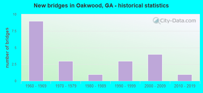
- New bridges - historical statistics
- 91960-1969
- 31970-1979
- 11980-1989
- 31990-1999
- 42000-2009
- 12010-2019

- Reconstructed bridges - Historical Statistics
- 21980-1989
- 21990-1999


- Bridge Condition - Deck
- 15.4%Very good
- 69.2%Good
- 15.4%Satisfactory

- Bridge Condition - Superstructure
- 7.7%Excellent
- 23.1%Very good
- 69.2%Good

- Bridge Condition - Substructure
- 15.4%Very good
- 76.9%Good
- 7.7%Satisfactory

- Bridge Condition - Channel
- 22.2%Very good
- 55.6%Good
- 22.2%Satisfactory

- Bridge Condition - Culverts
- 87.5%Good
- 12.5%Satisfactory
Find on map >> Show street view
Structure Number: 1390022, Location: IN OAKWOOD (Lat: 34.245728, Lng: -83.883978), Route carried "on" structure: State highway 53, Year Built: 1969, Year Reconstructed: 1996, Status: Open, Structure Length: 0.67m (2.20ft), Average Daily Traffic: 19,040 (year 2012), Truck Traffic: 4%, Average Future Daily Traffic: 28,560 (year 2032), Design Load: HS 20+Mod, Features Intersected: BALUS CREEK, Facility Carried by Structure: MUNDY MILL ROAD
Minimum Vertical Clearance: 30+ m (98+ ft), Kilometerpoint: 19.312, Lanes on structure: 4, Base Highway Network: Yes, Owner: State Highway Agency, Approaching Roadway Width: 21.6m (70.9ft), Skew: 12 degrees, Material/Design: Concrete, Design/Construction: Culvert, Number Of Spans In Main Unit: 2, Length of Maximum Span: 3.0m (9.8ft)
Condition: Channel: Good, Culverts: Good, Structural Evaluation: Better than present minimum criteria, Waterway Adequacy: Superior to present desirable criteria, Approach Roadway Alignment: Equal to present desirable criteria, Designated Inspection Frequency: Every 24 months, Inspection Date: April 2021, Bridge Improvement Cost: $86,000, Roadway Improvement Cost: $9,000, Total Project Cost: $129,000
Find on map >> Show street view
Structure Number: 1390023, Location: IN OAKWOOD (Lat: 34.236228, Lng: -83.873808), Route carried "on" structure: State highway 53, Year Built: 1969, Year Reconstructed: 1994, Status: Open, Structure Length: 5.43m (17.81ft), Average Daily Traffic: 27,280 (year 2012), Truck Traffic: 1%, Average Future Daily Traffic: 40,920 (year 2032), Design Load: HS 20+Mod, Features Intersected: NOR SOUTHERN RAILROAD
Minimum Vertical Clearance: 30+ m (98+ ft), Kilometerpoint: 20.921, Lanes on structure: 4, Base Highway Network: Yes, Owner: State Highway Agency, Approaching Roadway Width: 17.1m (56.1ft), Skew: 10 degrees, Material/Design: Steel, Design/Construction: Stringer/Multi-beam, Number Of Spans In Main Unit: 3, Length of Maximum Span: 19.5m (64.0ft), Curb-To-Curb Width: 26.8m (87.9ft), Out-to-Out Width: 27.8m (91.2ft)
Condition: Deck: Good, Superstructure: Good, Substructure: Good, Operating Rating: 29.9 metric tons, Method Used To Determine Operating Rating: Load Factor (LF), Inventory Rating: 17.2 metric tons, Method Used To Determine Inventory Rating: Load Factor (LF), Structural Evaluation: Meets minimum limits, Deck Geometry: Superior to present desirable criteria, Underclear: Equal to present minimum criteria, Approach Roadway Alignment: Equal to present desirable criteria, Designated Inspection Frequency: Every 24 months, Inspection Date: June 2021, Bridge Improvement Cost: $1,075,000, Roadway Improvement Cost: $107,000, Total Project Cost: $1,612,000, Deck Structure Type: Concrete Cast-file-Place
Find on map >> Show street view
Structure Number: 1390055, Location: IN OAKWOOD (Lat: 34.246258, Lng: -83.835047), Route carried "on" structure: ServiceCounty highway 472, Year Built: 1967, Status: Open, Structure Length: 9.14m (29.99ft), Average Daily Traffic: 1,570 (year 2012), Truck Traffic: 1%, Average Future Daily Traffic: 2,355 (year 2032), Design Load: HS 15, Features Intersected: SR 419 (I-985 US 23), Facility Carried by Structure: ELACHEE ROAD
Minimum Vertical Clearance: 30+ m (98+ ft), Kilometerpoint: 1.609, Lanes on structure: 2, Lanes under structure: 4, Base Highway Network: Yes, Owner: State Highway Agency, Approaching Roadway Width: 6.4m (21.0ft), Material/Design: Steel continuous, Design/Construction: Stringer/Multi-beam, Number Of Spans In Main Unit: 4, Length of Maximum Span: 26.2m (86.0ft), Curb or Sidewalk Widths: Left: 0.6m (2.0ft), Right: 0.6m (2.0ft), Curb-To-Curb Width: 7.3m (24.0ft), Out-to-Out Width: 9.3m (30.5ft)
Condition: Deck: Good, Superstructure: Good, Substructure: Satisfactory, Operating Rating: 32.6 metric tons, Method Used To Determine Operating Rating: Load Factor (LF), Inventory Rating: 19.9 metric tons, Method Used To Determine Inventory Rating: Load Factor (LF), Structural Evaluation: Somewhat better than minimum adequacy, Deck Geometry: Meets minimum limits, Underclear: Equal to present minimum criteria, Approach Roadway Alignment: Equal to present desirable criteria, Designated Inspection Frequency: Every 24 months, Inspection Date: June 2021, Bridge Improvement Cost: $1,172,000, Roadway Improvement Cost: $117,000, Total Project Cost: $1,758,000, Deck Structure Type: Concrete Cast-file-Place
Find on map >> Show street view
Structure Number: 1390056, Location: IN OAKWOOD (Lat: 34.215619, Lng: -83.881069), Route carried "on" structure: County highway 524, Year Built: 1968, Status: Open, Structure Length: 6.58m (21.59ft), Average Daily Traffic: 4,760 (year 2012), Truck Traffic: 1%, Average Future Daily Traffic: 7,140 (year 2032), Design Load: HS 20, Features Intersected: SR 419 (I-985 US 23), Facility Carried by Structure: PLAINVIEW ROAD
Minimum Vertical Clearance: 30+ m (98+ ft), Kilometerpoint: 0.000, Lanes on structure: 2, Lanes under structure: 4, Base Highway Network: Yes, Owner: State Highway Agency, Approaching Roadway Width: 7.3m (24.0ft), Skew: 1 degrees, Material/Design: Steel continuous, Design/Construction: Stringer/Multi-beam, Number Of Spans In Main Unit: 4, Length of Maximum Span: 21.9m (71.9ft), Curb or Sidewalk Widths: Left: 0.2m (0.7ft), Right: 0.2m (0.7ft), Curb-To-Curb Width: 9.3m (30.5ft), Out-to-Out Width: 10.6m (34.8ft)
Condition: Deck: Good, Superstructure: Good, Substructure: Good, Operating Rating: 33.5 metric tons, Method Used To Determine Operating Rating: Load Factor (LF), Inventory Rating: 19.9 metric tons, Method Used To Determine Inventory Rating: Load Factor (LF), Structural Evaluation: Somewhat better than minimum adequacy, Deck Geometry: Meets minimum limits, Underclear: Somewhat better than minimum adequacy, Approach Roadway Alignment: Equal to present desirable criteria, Designated Inspection Frequency: Every 24 months, Inspection Date: May 2021, Bridge Improvement Cost: $844,000, Roadway Improvement Cost: $84,000, Total Project Cost: $1,266,000, Deck Structure Type: Concrete Cast-file-Place
Find on map >> Show street view
Structure Number: 139501, Location: 3.7 MI S OF CLERMONT (Lat: 34.413739, Lng: -83.801550), Route carried "on" structure: County highway 109, Year Built: 1987, Status: Open, Structure Length: 1.31m (4.30ft), Average Daily Traffic: 490 (year 2012), Truck Traffic: 1%, Average Future Daily Traffic: 735 (year 2032), Design Load: HS 20+Mod, Features Intersected: EAST FORK LITTLE RIVER, Facility Carried by Structure: CLAUDE PECK ROAD
Minimum Vertical Clearance: 30+ m (98+ ft), Kilometerpoint: 1.609, Lanes on structure: 2, Base Highway Network: Yes, Owner: County Highway Agency, Approaching Roadway Width: 6.1m (20.0ft), Material/Design: Concrete, Design/Construction: Culvert, Number Of Spans In Main Unit: 4, Length of Maximum Span: 3.0m (9.8ft)
Condition: Channel: Satisfactory, Culverts: Good, Operating Rating: 55.3 metric tons, Method Used To Determine Operating Rating: Field evaluation and documented engineering judgment, Inventory Rating: 32.6 metric tons, Method Used To Determine Inventory Rating: Field evaluation and documented engineering judgment, Structural Evaluation: Better than present minimum criteria, Waterway Adequacy: Equal to present desirable criteria, Approach Roadway Alignment: Equal to present minimum criteria, Designated Inspection Frequency: Every 24 months, Inspection Date: May 2021, Bridge Improvement Cost: $168,000, Roadway Improvement Cost: $17,000, Total Project Cost: $252,000
Find on map >> Show street view
Structure Number: 1395019, Location: 5.2 MI SW OF GAINESVILLE (Lat: 34.247478, Lng: -83.890569), Route carried "on" structure: County highway 487, Year Built: 1994, Status: Open, Structure Length: 1.19m (3.90ft), Average Daily Traffic: 3,780 (year 2012), Truck Traffic: 1%, Average Future Daily Traffic: 5,670 (year 2032), Design Load: HS 20+Mod, Features Intersected: BALUS CREEK, Facility Carried by Structure: OLD FLOWERY BRANCH
Minimum Vertical Clearance: 30+ m (98+ ft), Kilometerpoint: 1.609, Lanes on structure: 2, Base Highway Network: Yes, Owner: County Highway Agency, Approaching Roadway Width: 4.9m (16.1ft), Material/Design: Concrete, Design/Construction: Culvert, Number Of Spans In Main Unit: 4, Length of Maximum Span: 2.7m (8.9ft)
Condition: Channel: Good, Culverts: Good, Operating Rating: 61.6 metric tons, Method Used To Determine Operating Rating: Load Factor (LF), Inventory Rating: 37.1 metric tons, Method Used To Determine Inventory Rating: Load Factor (LF), Structural Evaluation: Better than present minimum criteria, Waterway Adequacy: Meets minimum limits, Approach Roadway Alignment: Equal to present minimum criteria, Designated Inspection Frequency: Every 24 months, Inspection Date: April 2021, Bridge Improvement Cost: $152,000, Roadway Improvement Cost: $15,000, Total Project Cost: $229,000
Find on map >> Show street view
Structure Number: 1395026, Location: 4.1 MI SE OF OAKWOOD (Lat: 34.192078, Lng: -83.827808), Route carried "on" structure: County highway 688, Year Built: 1974, Status: Open, Structure Length: 0.67m (2.20ft), Average Daily Traffic: 1,670 (year 2012), Truck Traffic: 1%, Average Future Daily Traffic: 2,505 (year 2032), Design Load: HS 20+Mod, Features Intersected: CANEY CREEK, Facility Carried by Structure: PINE VALE ROAD
Minimum Vertical Clearance: 30+ m (98+ ft), Kilometerpoint: 0.000, Lanes on structure: 2, Base Highway Network: Yes, Owner: County Highway Agency, Approaching Roadway Width: 6.1m (20.0ft), Skew: 1 degrees, Material/Design: Concrete, Design/Construction: Culvert, Number Of Spans In Main Unit: 2, Length of Maximum Span: 3.0m (9.8ft)
Condition: Channel: Good, Culverts: Good, Structural Evaluation: Better than present minimum criteria, Waterway Adequacy: Superior to present desirable criteria, Approach Roadway Alignment: Better than present minimum criteria, Designated Inspection Frequency: Every 24 months, Inspection Date: May 2021, Bridge Improvement Cost: $86,000, Roadway Improvement Cost: $9,000, Total Project Cost: $129,000
Find on map >> Show street view
Structure Number: 139507, Location: 1 MI N OF CLERMONT (Lat: 34.491808, Lng: -83.778269), Route carried "on" structure: County highway 3, Year Built: 1970, Status: Open, Structure Length: 0.67m (2.20ft), Average Daily Traffic: 490 (year 2012), Truck Traffic: 1%, Average Future Daily Traffic: 735 (year 2032), Design Load: H 15, Features Intersected: EUBANK CREEK, Facility Carried by Structure: STRINGER ROAD
Minimum Vertical Clearance: 30+ m (98+ ft), Kilometerpoint: 0.000, Lanes on structure: 2, Base Highway Network: Yes, Owner: County Highway Agency, Approaching Roadway Width: 6.1m (20.0ft), Skew: 1 degrees, Material/Design: Concrete, Design/Construction: Culvert, Number Of Spans In Main Unit: 2, Length of Maximum Span: 3.0m (9.8ft)
Condition: Channel: Very good, Culverts: Good, Operating Rating: 41.7 metric tons, Method Used To Determine Operating Rating: Field evaluation and documented engineering judgment, Inventory Rating: 24.4 metric tons, Method Used To Determine Inventory Rating: Field evaluation and documented engineering judgment, Structural Evaluation: Equal to present minimum criteria, Waterway Adequacy: Equal to present desirable criteria, Approach Roadway Alignment: Equal to present minimum criteria, Designated Inspection Frequency: Every 24 months, Inspection Date: April 2021, Bridge Improvement Cost: $86,000, Roadway Improvement Cost: $9,000, Total Project Cost: $129,000
Find on map >> Show street view
Structure Number: 1395074, Location: .5 MI N OF OAKWOOD (Lat: 34.232997, Lng: -83.882339), Route carried "on" structure: County highway 2434, Year Built: 1992, Status: Open, Structure Length: 0.79m (2.59ft), Average Daily Traffic: 7,390 (year 2012), Truck Traffic: 1%, Average Future Daily Traffic: 11,085 (year 2032), Design Load: HS 20+Mod, Features Intersected: BALUS CREEK TRIB, Facility Carried by Structure: OLD OAKWOOD RD
Minimum Vertical Clearance: 30+ m (98+ ft), Kilometerpoint: 4.828, Lanes on structure: 2, Base Highway Network: Yes, Owner: County Highway Agency, Approaching Roadway Width: 7.3m (24.0ft), Material/Design: Concrete, Design/Construction: Culvert, Number Of Spans In Main Unit: 3, Length of Maximum Span: 2.4m (7.9ft)
Condition: Channel: Good, Culverts: Good, Operating Rating: 55.3 metric tons, Method Used To Determine Operating Rating: Field evaluation and documented engineering judgment, Inventory Rating: 32.6 metric tons, Method Used To Determine Inventory Rating: Field evaluation and documented engineering judgment, Structural Evaluation: Better than present minimum criteria, Waterway Adequacy: Equal to present desirable criteria, Approach Roadway Alignment: Equal to present desirable criteria, Designated Inspection Frequency: Every 24 months, Inspection Date: May 2021, Bridge Improvement Cost: $102,000, Roadway Improvement Cost: $10,000, Total Project Cost: $152,000
Find on map >> Show street view
Structure Number: 1395088, Location: IN OAKWOOD (Lat: 34.257789, Lng: -83.846578), Route carried "on" structure: State highway 13, Year Built: 1998, Status: Open, Structure Length: 8.69m (28.51ft), Average Daily Traffic: 13,690 (year 2012), Truck Traffic: 6%, Average Future Daily Traffic: 20,535 (year 2032), Design Load: HS 20+Mod, Features Intersected: NOR SOUTHERN RAILROAD, Facility Carried by Structure: ATLANTA HIGHWAY
Minimum Vertical Clearance: 30+ m (98+ ft), Kilometerpoint: 19.312, Lanes on structure: 2, Base Highway Network: Yes, Owner: State Highway Agency, Approaching Roadway Width: 11.3m (37.1ft), Material/Design: Prestressed concrete, Design/Construction: Stringer/Multi-beam, Number Of Spans In Main Unit: 3, Length of Maximum Span: 31.1m (102.0ft), Curb-To-Curb Width: 13.4m (44.0ft), Out-to-Out Width: 14.4m (47.2ft)
Condition: Deck: Good, Superstructure: Good, Substructure: Good, Operating Rating: 66.2 metric tons, Method Used To Determine Operating Rating: Load Factor (LF), Inventory Rating: 32.6 metric tons, Method Used To Determine Inventory Rating: Load Factor (LF), Structural Evaluation: Better than present minimum criteria, Deck Geometry: Equal to present minimum criteria, Underclear: Better than present minimum criteria, Approach Roadway Alignment: Somewhat better than minimum adequacy, Designated Inspection Frequency: Every 24 months, Inspection Date: June 2021, Bridge Improvement Cost: $1,114,000, Roadway Improvement Cost: $111,000, Total Project Cost: $1,670,000, Deck Structure Type: Concrete Cast-file-Place
Find on map >> Show street view
Structure Number: 139509, Location: 3.4 MI S OF FLOWERY BR (Lat: 34.140050, Lng: -83.950139), Route carried "on" structure: State highway 347, Year Built: 2002, Status: Open, Structure Length: 6.52m (21.39ft), Average Daily Traffic: 19,870 (year 2012), Truck Traffic: 1%, Average Future Daily Traffic: 29,805 (year 2032), Design Load: HS 20+Mod, Features Intersected: SR 419 (I-985 US 23), Facility Carried by Structure: FRIENDSHIP ROAD
Minimum Vertical Clearance: 30+ m (98+ ft), Kilometerpoint: 6.437, Lanes on structure: 7, Lanes under structure: 4, Base Highway Network: Yes, Owner: State Highway Agency, Approaching Roadway Width: 6.4m (21.0ft), Material/Design: Prestressed concrete, Design/Construction: Stringer/Multi-beam, Number Of Spans In Main Unit: 2, Length of Maximum Span: 32.6m (107.0ft), Curb or Sidewalk Widths: Left: 1.8m (5.9ft), Right: 1.7m (5.6ft), Curb-To-Curb Width: 29.9m (98.1ft), Out-to-Out Width: 34.2m (112.2ft)
Condition: Deck: Good, Superstructure: Very good, Substructure: Good, Operating Rating: 57.1 metric tons, Method Used To Determine Operating Rating: Allowable Stress (AS), Inventory Rating: 33.5 metric tons, Method Used To Determine Inventory Rating: Allowable Stress (AS), Structural Evaluation: Better than present minimum criteria, Deck Geometry: Equal to present minimum criteria, Underclear: Better than present minimum criteria, Approach Roadway Alignment: Equal to present minimum criteria, Designated Inspection Frequency: Every 24 months, Inspection Date: May 2021, Bridge Improvement Cost: $1,976,000, Roadway Improvement Cost: $198,000, Total Project Cost: $2,964,000, Deck Structure Type: Concrete Cast-file-Place
Find on map >> Show street view
Structure Number: 1395096, Location: IN OAK WOOD (Lat: 34.225514, Lng: -83.865644), Route carried "on" structure: Interstate 985, Year Built: 2009, Status: Open, Structure Length: 7.56m (24.80ft), Average Daily Traffic: 50,610 (year 2012), Truck Traffic: 1%, Average Future Daily Traffic: 75,915 (year 2032), Design Load: HS 20+Mod, Features Intersected: SR 53
Minimum Vertical Clearance: 30+ m (98+ ft), Kilometerpoint: 25.750, Lanes on structure: 5, Lanes under structure: 10, Base Highway Network: Yes, Owner: State Highway Agency, Approaching Roadway Width: 23.2m (76.1ft), Skew: 30 degrees, Material/Design: Prestressed concrete, Design/Construction: Stringer/Multi-beam, Number Of Spans In Main Unit: 4, Length of Maximum Span: 25.6m (84.0ft), Curb-To-Curb Width: 50.3m (165.0ft), Out-to-Out Width: 52.7m (172.9ft)
Condition: Deck: Good, Superstructure: Good, Substructure: Good, Operating Rating: 59.8 metric tons, Method Used To Determine Operating Rating: Allowable Stress (AS), Inventory Rating: 32.6 metric tons, Method Used To Determine Inventory Rating: Allowable Stress (AS), Structural Evaluation: Better than present minimum criteria, Deck Geometry: Superior to present desirable criteria, Underclear: Equal to present minimum criteria, Approach Roadway Alignment: Equal to present desirable criteria, Designated Inspection Frequency: Every 24 months, Inspection Date: May 2021, Bridge Improvement Cost: $1,762,000, Roadway Improvement Cost: $176,000, Total Project Cost: $2,643,000, Deck Structure Type: Concrete Cast-file-Place, Wearing Surface/Protective System: Deck Protection: Epoxy Coated Reinforcing
Find on map >> Show street view
Structure Number: 1395097, Location: IN OAK WOOD (Lat: 34.227839, Lng: -83.861400), Route carried "on" structure: Ramp Interstate 985, Year Built: 2007, Status: Open, Structure Length: 2.19m (7.19ft), Average Daily Traffic: 6,710 (year 2012), Truck Traffic: 1%, Average Future Daily Traffic: 10,065 (year 2032), Design Load: HS 20+Mod, Features Intersected: RAMP TO 985 NORTH, Facility Carried by Structure: STATE ROUTE 53
Minimum Vertical Clearance: 30+ m (98+ ft), Kilometerpoint: 25.750, Lanes on structure: 1, Lanes under structure: 1, Base Highway Network: Yes, Owner: State Highway Agency, Approaching Roadway Width: 7.9m (25.9ft), Skew: 7 degrees, Material/Design: Prestressed concrete, Design/Construction: Stringer/Multi-beam, Number Of Spans In Main Unit: 1, Length of Maximum Span: 21.9m (71.9ft), Curb-To-Curb Width: 9.0m (29.5ft), Out-to-Out Width: 9.9m (32.5ft)
Condition: Deck: Very good, Superstructure: Very good, Substructure: Very good, Operating Rating: 49.8 metric tons, Method Used To Determine Operating Rating: Allowable Stress (AS), Inventory Rating: 32.6 metric tons, Method Used To Determine Inventory Rating: Allowable Stress (AS), Structural Evaluation: Equal to present desirable criteria, Deck Geometry: Superior to present desirable criteria, Underclear: Superior to present desirable criteria, Approach Roadway Alignment: Better than present minimum criteria, Designated Inspection Frequency: Every 24 months, Inspection Date: May 2021, Bridge Improvement Cost: $205,000, Roadway Improvement Cost: $20,000, Total Project Cost: $307,000, Deck Structure Type: Concrete Cast-file-Place, Wearing Surface/Protective System: Deck Protection: Epoxy Coated Reinforcing
Find on map >> Show street view
Structure Number: 1395098, Location: IN OAK WOOD (Lat: 34.230108, Lng: -83.858297), Route carried "on" structure: State highway 13, Year Built: 2007, Status: Open, Structure Length: 8.75m (28.71ft), Average Daily Traffic: 19,360 (year 2012), Truck Traffic: 1%, Average Future Daily Traffic: 29,040 (year 2032), Design Load: HS 20+Mod, Features Intersected: SR 419 (I-985 US 23), Facility Carried by Structure: ATLANTA HIGHWAY
Minimum Vertical Clearance: 30+ m (98+ ft), Kilometerpoint: 16.093, Lanes on structure: 5, Lanes under structure: 7, Base Highway Network: Yes, Owner: State Highway Agency, Approaching Roadway Width: 19.2m (63.0ft), Skew: 22 degrees, Material/Design: Prestressed concrete, Design/Construction: Stringer/Multi-beam, Number Of Spans In Main Unit: 4, Length of Maximum Span: 23.8m (78.1ft), Curb or Sidewalk Widths: Left: 1.8m (5.9ft), Right: 1.8m (5.9ft), Curb-To-Curb Width: 24.0m (78.7ft), Out-to-Out Width: 28.3m (92.8ft)
Condition: Deck: Good, Superstructure: Very good, Substructure: Good, Operating Rating: 59.8 metric tons, Method Used To Determine Operating Rating: Allowable Stress (AS), Inventory Rating: 32.6 metric tons, Method Used To Determine Inventory Rating: Allowable Stress (AS), Structural Evaluation: Better than present minimum criteria, Deck Geometry: Equal to present desirable criteria, Underclear: Equal to present minimum criteria, Approach Roadway Alignment: Better than present minimum criteria, Designated Inspection Frequency: Every 24 months, Inspection Date: May 2021, Bridge Improvement Cost: $2,039,000, Roadway Improvement Cost: $204,000, Total Project Cost: $3,058,000, Deck Structure Type: Concrete Cast-file-Place, Wearing Surface/Protective System: Deck Protection: Epoxy Coated Reinforcing
Find on map >> Show street view
Structure Number: 1395113, Location: 2 MI S OF OAKWOOD (Lat: 34.204667, Lng: -83.891417), Route carried "on" structure: Ramp Interstate 985, Year Built: 2019, Status: Open, Structure Length: 3.81m (12.50ft), Average Daily Traffic: 2,972 (year 2020), Truck Traffic: 1%, Average Future Daily Traffic: 4,684 (year 2040), Design Load: HL 93, Features Intersected: MUD CREEK
Minimum Vertical Clearance: 30+ m (98+ ft), Kilometerpoint: 22.531, Lanes on structure: 1, Owner: State Highway Agency, Approaching Roadway Width: 9.1m (29.9ft), Skew: 2 degrees, Material/Design: Prestressed concrete, Design/Construction: Stringer/Multi-beam, Number Of Spans In Main Unit: 1, Length of Maximum Span: 38.1m (125.0ft), Curb-To-Curb Width: 9.1m (29.9ft), Out-to-Out Width: 10.1m (33.1ft)
Condition: Deck: Very good, Superstructure: Excellent, Substructure: Very good, Channel: Very good, Operating Rating: 95.2 metric tons, Method Used To Determine Operating Rating: Load Factor (LF), Inventory Rating: 46.2 metric tons, Method Used To Determine Inventory Rating: Load Factor (LF), Structural Evaluation: Equal to present desirable criteria, Deck Geometry: Superior to present desirable criteria, Waterway Adequacy: Superior to present desirable criteria, Approach Roadway Alignment: Better than present minimum criteria, Length Of Structure Improvement: 4.57m (14.99ft), Designated Inspection Frequency: Every 24 months, Inspection Date: June 2021, Bridge Improvement Cost: $11,100,000, Roadway Improvement Cost: $1,110,000, Total Project Cost: $16,650,000 ( Estimate for 2020), Deck Structure Type: Concrete Cast-file-Place
Find on map >> Show street view
Structure Number: 1530001, Location: 4 MI SW OF ELKO (Lat: 32.301397, Lng: -83.761186), Route carried "on" structure: US 41, Year Built: 1961, Status: Open, Structure Length: 1.01m (3.31ft), Average Daily Traffic: 630 (year 2012), Truck Traffic: 1%, Average Future Daily Traffic: 945 (year 2032), Design Load: HS 20+Mod, Features Intersected: BIG CREEK TRIB.
Minimum Vertical Clearance: 30+ m (98+ ft), Kilometerpoint: 1.609, Lanes on structure: 2, Base Highway Network: Yes, Owner: State Highway Agency, Approaching Roadway Width: 8.2m (26.9ft), Skew: 2 degrees, Material/Design: Concrete, Design/Construction: Culvert, Number Of Spans In Main Unit: 3, Length of Maximum Span: 3.0m (9.8ft)
Condition: Channel: Good, Culverts: Good, Operating Rating: 55.3 metric tons, Method Used To Determine Operating Rating: Field evaluation and documented engineering judgment, Inventory Rating: 32.6 metric tons, Method Used To Determine Inventory Rating: Field evaluation and documented engineering judgment, Structural Evaluation: Better than present minimum criteria, Waterway Adequacy: Equal to present desirable criteria, Approach Roadway Alignment: Equal to present desirable criteria, Designated Inspection Frequency: Every 24 months, Inspection Date: July 2021, Bridge Improvement Cost: $129,000, Roadway Improvement Cost: $13,000, Total Project Cost: $193,000
Find on map >> Show street view
Structure Number: 153001, Location: 6.9 MI SE OF PERRY (Lat: 32.411808, Lng: -83.636428), Route carried "on" structure: US 341, Year Built: 1971, Status: Open, Structure Length: 8.84m (29.00ft), Average Daily Traffic: 4,330 (year 2012), Truck Traffic: 1%, Average Future Daily Traffic: 6,495 (year 2032), Design Load: HS 20+Mod, Features Intersected: NS RAILROAD
Minimum Vertical Clearance: 30+ m (98+ ft), Kilometerpoint: 9.656, Lanes on structure: 2, Base Highway Network: Yes, Owner: State Highway Agency, Approaching Roadway Width: 11.6m (38.1ft), Material/Design: Steel, Design/Construction: Stringer/Multi-beam, Number Of Spans In Main Unit: 5, Length of Maximum Span: 19.5m (64.0ft), Curb or Sidewalk Widths: Left: 0.2m (0.7ft), Right: 0.2m (0.7ft), Curb-To-Curb Width: 11.9m (39.0ft), Out-to-Out Width: 12.8m (42.0ft)
Condition: Deck: Satisfactory, Superstructure: Good, Substructure: Good, Operating Rating: 45.3 metric tons, Method Used To Determine Operating Rating: Load Factor (LF), Inventory Rating: 27.2 metric tons, Method Used To Determine Inventory Rating: Load Factor (LF), Structural Evaluation: Equal to present minimum criteria, Deck Geometry: Somewhat better than minimum adequacy, Underclear: Equal to present minimum criteria, Approach Roadway Alignment: Equal to present minimum criteria, Designated Inspection Frequency: Every 24 months, Inspection Date: August 2021, Bridge Improvement Cost: $1,133,000, Roadway Improvement Cost: $113,000, Total Project Cost: $1,700,000, Deck Structure Type: Concrete Cast-file-Place
Find on map >> Show street view
Structure Number: 153002, Location: 3.5 MI W OF ELKO (Lat: 32.336703, Lng: -83.767642), Route carried "on" structure: State highway 26, Year Built: 1963, Status: Open, Structure Length: 7.07m (23.20ft), Average Daily Traffic: 1,480 (year 2012), Truck Traffic: 1%, Average Future Daily Traffic: 2,220 (year 2032), Design Load: HS 20, Features Intersected: I-75@126.87 (EXIT 127)
Minimum Vertical Clearance: 30+ m (98+ ft), Kilometerpoint: 8.047, Lanes on structure: 2, Lanes under structure: 6, Base Highway Network: Yes, Owner: State Highway Agency, Approaching Roadway Width: 7.3m (24.0ft), Skew: 2 degrees, Material/Design: Prestressed concrete, Design/Construction: Stringer/Multi-beam, Number Of Spans In Main Unit: 4, Length of Maximum Span: 24.1m (79.1ft), Curb or Sidewalk Widths: Left: 0.6m (2.0ft), Right: 0.6m (2.0ft), Curb-To-Curb Width: 8.5m (27.9ft), Out-to-Out Width: 10.5m (34.4ft)
Condition: Deck: Satisfactory, Superstructure: Good, Substructure: Good, Operating Rating: 56.2 metric tons, Method Used To Determine Operating Rating: Load Factor (LF), Inventory Rating: 33.5 metric tons, Method Used To Determine Inventory Rating: Load Factor (LF), Structural Evaluation: Better than present minimum criteria, Deck Geometry: Somewhat better than minimum adequacy, Underclear: Somewhat better than minimum adequacy, Approach Roadway Alignment: Equal to present minimum criteria, Designated Inspection Frequency: Every 24 months, Inspection Date: July 2021, Bridge Improvement Cost: $906,000, Roadway Improvement Cost: $91,000, Total Project Cost: $1,360,000, Deck Structure Type: Concrete Cast-file-Place
Find on map >> Show street view
Structure Number: 153003, Location: 6.3 MI NE OF PERRY (Lat: 32.505997, Lng: -83.643606), Route carried "on" structure: State highway 127, Year Built: 1965, Status: Open, Structure Length: 0.70m (2.30ft), Average Daily Traffic: 4,250 (year 2012), Truck Traffic: 1%, Average Future Daily Traffic: 6,375 (year 2032), Design Load: HS 20+Mod, Features Intersected: MOSSY CREEK TRIB
Minimum Vertical Clearance: 30+ m (98+ ft), Kilometerpoint: 22.531, Lanes on structure: 2, Base Highway Network: Yes, Owner: State Highway Agency, Approaching Roadway Width: 7.9m (25.9ft), Material/Design: Concrete, Design/Construction: Culvert, Number Of Spans In Main Unit: 3, Length of Maximum Span: 2.1m (6.9ft)
Condition: Channel: Satisfactory, Culverts: Satisfactory, Operating Rating: 55.3 metric tons, Method Used To Determine Operating Rating: Load Factor (LF), Inventory Rating: 32.6 metric tons, Method Used To Determine Inventory Rating: Load Factor (LF), Structural Evaluation: Equal to present minimum criteria, Waterway Adequacy: Somewhat better than minimum adequacy, Approach Roadway Alignment: Better than present minimum criteria, Designated Inspection Frequency: Every 24 months, Underwater Inspection Frequency: Every 60 months, Inspection Date: August 2021, Underwater Inspection Date: May 2021, Bridge Improvement Cost: $90,000, Roadway Improvement Cost: $9,000, Total Project Cost: $135,000
Find on map >> Show street view
Structure Number: 1530041, Location: 4 MI SW OF ELKO (Lat: 32.301747, Lng: -83.761519), Route carried "on" structure: Interstate 75, Year Built: 1963, Year Reconstructed: 1996, Status: Open, Structure Length: 6.92m (22.70ft), Average Daily Traffic: 41,750 (year 2012), Truck Traffic: 1%, Average Future Daily Traffic: 62,625 (year 2032), Design Load: HS 20+Mod, Features Intersected: SR 7 (US 41)
Minimum Vertical Clearance: 30+ m (98+ ft), Kilometerpoint: 199.559, Lanes on structure: 3, Lanes under structure: 2, Base Highway Network: Yes, Owner: State Highway Agency, Approaching Roadway Width: 17.7m (58.1ft), Skew: 16 degrees, Material/Design: Steel, Design/Construction: Stringer/Multi-beam, Number Of Spans In Main Unit: 3, Length of Maximum Span: 30.8m (101.0ft), Curb-To-Curb Width: 20.5m (67.3ft), Out-to-Out Width: 21.2m (69.6ft)
Condition: Deck: Good, Superstructure: Good, Substructure: Good, Operating Rating: 48.0 metric tons, Method Used To Determine Operating Rating: Load Factor (LF), Inventory Rating: 29.0 metric tons, Method Used To Determine Inventory Rating: Load Factor (LF), Structural Evaluation: Better than present minimum criteria, Deck Geometry: Superior to present desirable criteria, Underclear: High priority of corrective action, Approach Roadway Alignment: Equal to present desirable criteria, Length Of Structure Improvement: 13.84m (45.41ft), Designated Inspection Frequency: Every 24 months, Inspection Date: July 2021, Bridge Improvement Cost: $1,129,000, Roadway Improvement Cost: $113,000, Total Project Cost: $1,693,000, Deck Structure Type: Concrete Cast-file-Place
Find on map >> Show street view
Structure Number: 153005, Location: PERRY - WESTSIDE (Lat: 32.463578, Lng: -83.747733), Route carried "on" structure: Interstate 75, Year Built: 1962, Year Reconstructed: 1993, Status: Open, Structure Length: 4.54m (14.90ft), Average Daily Traffic: 49,510 (year 2012), Truck Traffic: 1%, Average Future Daily Traffic: 74,265 (year 2032), Design Load: HS 20+Mod, Features Intersected: NS RAILROAD
Minimum Vertical Clearance: 30+ m (98+ ft), Kilometerpoint: 218.871, Lanes on structure: 6, Base Highway Network: Yes, Owner: State Highway Agency, Approaching Roadway Width: 36.6m (120.1ft), Skew: 32 degrees, Material/Design: Concrete continuous, Design/Construction: Tee Beam, Number Of Spans In Main Unit: 3, Length of Maximum Span: 17.4m (57.1ft), Curb-To-Curb Width: 40.7m (133.5ft), Out-to-Out Width: 42.4m (139.1ft)
Condition: Deck: Good, Superstructure: Good, Substructure: Good, Operating Rating: 46.2 metric tons, Method Used To Determine Operating Rating: Load Factor (LF), Inventory Rating: 27.2 metric tons, Method Used To Determine Inventory Rating: Load Factor (LF), Structural Evaluation: Equal to present minimum criteria, Deck Geometry: Superior to present desirable criteria, Underclear: Better than present minimum criteria, Approach Roadway Alignment: Equal to present desirable criteria, Designated Inspection Frequency: Every 24 months, Inspection Date: August 2021, Bridge Improvement Cost: $1,217,000, Roadway Improvement Cost: $122,000, Total Project Cost: $1,826,000, Deck Structure Type: Concrete Cast-file-Place, Wearing Surface/Protective System: Wearing Surface: Bituminous
Find on map >> Show street view
Structure Number: 1390055, Location: IN OAKWOOD (Lat: 34.246258, Lng: -83.835047), Route carried "under" structure: Interstate 985, Structure Length: 0. m, Average Daily Traffic: 43,100 (year 1998), Truck Traffic: 1%, Features Intersected: CR 472 ELACHEE ROAD, Facility Carried by Structure: ELACHEE ROAD
Minimum Vertical Clearance: 7.06m (23.16ft), Kilometerpoint: 28.968, Lanes on structure: 2, Length of Maximum Span: 0.0m
Find on map >> Show street view
Structure Number: 1390056, Location: IN OAKWOOD (Lat: 34.215619, Lng: -83.881069), Route carried "under" structure: Interstate 985, Structure Length: 0. m, Average Daily Traffic: 45,600 (year 1998), Truck Traffic: 1%, Features Intersected: CR 524 PLAINVIEW ROAD, Facility Carried by Structure: PLAINVIEW ROAD
Minimum Vertical Clearance: 6.07m (19.91ft), Kilometerpoint: 24.140, Lanes on structure: 2, Length of Maximum Span: 0.0m
Find on map >> Show street view
Structure Number: 1395096, Location: IN OAK WOOD (Lat: 34.225514, Lng: -83.865644), Route carried "under" structure: State highway 53, Structure Length: 0. m, Average Daily Traffic: 32,300 (year 1998), Truck Traffic: 1%, Features Intersected: SR 419 N (I-985 US23), Facility Carried by Structure: I-985 NB, SB AND S
Minimum Vertical Clearance: 5.91m (19.39ft), Kilometerpoint: 19.312, Lanes on structure: 5, Length of Maximum Span: 0.0m
Find on map >> Show street view
Structure Number: 1395097, Location: IN OAK WOOD (Lat: 34.227839, Lng: -83.861400), Route carried "under" structure: Ramp Interstate 985, Structure Length: 0. m, Average Daily Traffic: 49,800 (year 2006), Truck Traffic: 1%, Features Intersected: 985 RAMP NORTH TO SR 13, Facility Carried by Structure: STATE ROUTE 53
Minimum Vertical Clearance: 5.48m (17.98ft), Kilometerpoint: 25.750, Lanes on structure: 1, Length of Maximum Span: 0.0m
Find on map >> Show street view
Structure Number: 1395098, Location: IN OAK WOOD (Lat: 34.230108, Lng: -83.858297), Route carried "under" structure: Interstate 985, Structure Length: 0. m, Average Daily Traffic: 43,100 (year 1998), Truck Traffic: 1%, Features Intersected: SR13 ATLANTA HIGHWAY, Facility Carried by Structure: ATLANTA HIGHWAY
Minimum Vertical Clearance: 5.46m (17.91ft), Kilometerpoint: 25.750, Lanes on structure: 5, Length of Maximum Span: 0.0m
Find on map >> Show street view
Structure Number: 1395098, Location: IN OAK WOOD (Lat: 34.230108, Lng: -83.858297), Route carried "under" structure: Interstate 985, Structure Length: 0. m, Average Daily Traffic: 43,100 (year 1998), Truck Traffic: 1%, Features Intersected: SR 13 ATLANTA HIGH WAY, Facility Carried by Structure: ATLANTA HIGHWAY
Minimum Vertical Clearance: 6.42m (21.06ft), Kilometerpoint: 25.750, Lanes on structure: 5, Length of Maximum Span: 0.0m
Find on map >> Show street view
Structure Number: 1395098, Location: IN OAK WOOD (Lat: 34.230108, Lng: -83.858297), Route carried "under" structure: Interstate 985, Structure Length: 0. m, Average Daily Traffic: 43,100 (year 2006), Truck Traffic: 1%, Features Intersected: SR13 ATLANTA HIGHWAY, Facility Carried by Structure: ATLANTA HIGHWAY
Minimum Vertical Clearance: 6.83m (22.41ft), Kilometerpoint: 25.750, Lanes on structure: 5, Length of Maximum Span: 0.0m