Bridge Statistics for Oak Valley, Texas (TX)
Condition, Traffic, Stress, Structural Evaluation, Project Costs
- National Bridge Inventory (NBI) Statistics
- 15Number of bridges
- 190ft / 57.5mTotal length
- $663,000Total costs
- 15,832Total average daily traffic
- 2,108Total average daily truck traffic
- 21,780Total future (year 2031) average daily traffic
- National Bridge Inventory (NBI) Registered Bridges for Oak Valley
- No street view available for this location
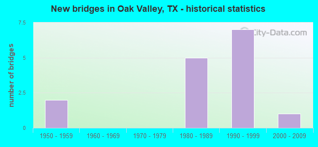
- New bridges - historical statistics
- 21950-1959
- 51980-1989
- 71990-1999
- 12000-2009


- Bridge Condition - Deck
- 6.7%Very good
- 60.0%Good
- 33.3%Satisfactory

- Bridge Condition - Superstructure
- 13.3%Very good
- 13.3%Good
- 60.0%Satisfactory
- 13.3%Fair

- Bridge Condition - Substructure
- 33.3%Good
- 60.0%Satisfactory
- 6.7%Fair

- Bridge Condition - Channel
- 26.7%Good
- 60.0%Satisfactory
- 13.3%Fair
Find on map >> Show street view
Structure Number: 181750016204088, Location: 8.90 MI W OF IH45 (Lat: 32.029364, Lng: -96.562261), Route carried "on" structure: State highway 31, Year Built: 1989, Status: Open, Structure Length: 5.70m (18.70ft), Average Daily Traffic: 3,046 (year 2020), Truck Traffic: 14%, Average Future Daily Traffic: 4,210 (year 2033), Design Load: HS 20, Features Intersected: BRIAR CREEK RELIEF
Minimum Vertical Clearance: 30+ m (98+ ft), Kilometerpoint: 25.632, Lanes on structure: 2, Owner: State Highway Agency, Approaching Roadway Width: 12.2m (40.0ft), Skew: 1 degrees, Material/Design: Concrete, Design/Construction: Stringer/Multi-beam, Number Of Spans In Main Unit: 6, Length of Maximum Span: 9.4m (30.8ft), Curb-To-Curb Width: 11.3m (37.1ft), Out-to-Out Width: 12.2m (40.0ft)
Condition: Deck: Satisfactory, Superstructure: Fair, Substructure: Satisfactory, Channel: Good, Operating Rating: 54.4 metric tons, Method Used To Determine Operating Rating: Assigned rating based on Load Factor Design (LFD) reported in metric tons, Inventory Rating: 32.7 metric tons, Method Used To Determine Inventory Rating: Assigned rating based on Load Factor Design (LFD) reported in metric tons, Structural Evaluation: Somewhat better than minimum adequacy, Deck Geometry: Equal to present minimum criteria, Waterway Adequacy: Superior to present desirable criteria, Approach Roadway Alignment: Equal to present desirable criteria, Designated Inspection Frequency: Every 24 months, Inspection Date: December 2019, Deck Structure Type: Concrete Cast-file-Place
Find on map >> Show street view
Structure Number: 181750016204089, Location: 8.60 MI W OF IH 45 (Lat: 32.030522, Lng: -96.560286), Route carried "on" structure: State highway 31, Year Built: 1989, Status: Open, Structure Length: 3.02m (9.91ft), Average Daily Traffic: 3,046 (year 2020), Truck Traffic: 14%, Average Future Daily Traffic: 4,210 (year 2033), Design Load: HS 20, Features Intersected: BRIAR CREEK
Minimum Vertical Clearance: 30+ m (98+ ft), Kilometerpoint: 25.856, Lanes on structure: 2, Owner: State Highway Agency, Approaching Roadway Width: 12.2m (40.0ft), Skew: 3 degrees, Material/Design: Concrete, Design/Construction: Stringer/Multi-beam, Number Of Spans In Main Unit: 3, Length of Maximum Span: 10.1m (33.1ft), Curb-To-Curb Width: 11.3m (37.1ft), Out-to-Out Width: 12.2m (40.0ft)
Condition: Deck: Good, Superstructure: Good, Substructure: Good, Channel: Satisfactory, Operating Rating: 54.4 metric tons, Method Used To Determine Operating Rating: Assigned rating based on Load Factor Design (LFD) reported in metric tons, Inventory Rating: 32.7 metric tons, Method Used To Determine Inventory Rating: Assigned rating based on Load Factor Design (LFD) reported in metric tons, Structural Evaluation: Better than present minimum criteria, Deck Geometry: Equal to present minimum criteria, Waterway Adequacy: Superior to present desirable criteria, Approach Roadway Alignment: Equal to present desirable criteria, Designated Inspection Frequency: Every 24 months, Inspection Date: December 2019, Deck Structure Type: Concrete Cast-file-Place
Find on map >> Show street view
Structure Number: 181750016204091, Location: 8.70 MI W OF IH 45 (Lat: 32.029842, Lng: -96.562286), Route carried "on" structure: State highway 31, Year Built: 1991, Status: Open, Structure Length: 5.70m (18.70ft), Average Daily Traffic: 3,267 (year 2019), Truck Traffic: 14%, Average Future Daily Traffic: 4,210 (year 2033), Design Load: HS 20, Features Intersected: BRIAR CREEK RELIEF
Minimum Vertical Clearance: 30+ m (98+ ft), Kilometerpoint: 25.627, Lanes on structure: 2, Owner: State Highway Agency, Approaching Roadway Width: 12.2m (40.0ft), Skew: 1 degrees, Material/Design: Concrete, Design/Construction: Stringer/Multi-beam, Number Of Spans In Main Unit: 6, Length of Maximum Span: 9.4m (30.8ft), Curb-To-Curb Width: 11.3m (37.1ft), Out-to-Out Width: 12.2m (40.0ft)
Condition: Deck: Satisfactory, Superstructure: Satisfactory, Substructure: Good, Channel: Good, Operating Rating: 54.4 metric tons, Method Used To Determine Operating Rating: Assigned rating based on Load Factor Design (LFD) reported in metric tons, Inventory Rating: 32.7 metric tons, Method Used To Determine Inventory Rating: Assigned rating based on Load Factor Design (LFD) reported in metric tons, Structural Evaluation: Equal to present minimum criteria, Deck Geometry: Equal to present minimum criteria, Waterway Adequacy: Superior to present desirable criteria, Approach Roadway Alignment: Equal to present desirable criteria, Designated Inspection Frequency: Every 24 months, Inspection Date: December 2019, Deck Structure Type: Concrete Cast-file-Place
Find on map >> Show street view
Structure Number: 181750016204092, Location: 8.60 MI W OF IH 45 (Lat: 32.031006, Lng: -96.560269), Route carried "on" structure: State highway 31, Year Built: 1991, Status: Open, Structure Length: 3.02m (9.91ft), Average Daily Traffic: 3,267 (year 2019), Truck Traffic: 14%, Average Future Daily Traffic: 4,210 (year 2033), Design Load: HS 20, Features Intersected: BRIAR CREEK
Minimum Vertical Clearance: 30+ m (98+ ft), Kilometerpoint: 25.851, Lanes on structure: 2, Owner: State Highway Agency, Approaching Roadway Width: 12.2m (40.0ft), Skew: 3 degrees, Material/Design: Concrete, Design/Construction: Stringer/Multi-beam, Number Of Spans In Main Unit: 3, Length of Maximum Span: 10.1m (33.1ft), Curb-To-Curb Width: 11.3m (37.1ft), Out-to-Out Width: 12.2m (40.0ft)
Condition: Deck: Good, Superstructure: Good, Substructure: Good, Channel: Satisfactory, Operating Rating: 54.4 metric tons, Method Used To Determine Operating Rating: Assigned rating based on Load Factor Design (LFD) reported in metric tons, Inventory Rating: 32.7 metric tons, Method Used To Determine Inventory Rating: Assigned rating based on Load Factor Design (LFD) reported in metric tons, Structural Evaluation: Better than present minimum criteria, Deck Geometry: Equal to present minimum criteria, Waterway Adequacy: Superior to present desirable criteria, Approach Roadway Alignment: Equal to present desirable criteria, Designated Inspection Frequency: Every 24 months, Inspection Date: December 2019, Deck Structure Type: Concrete Cast-file-Place
Find on map >> Show street view
Structure Number: 181750016209074, Location: 0.50 MI SW OF FM 2452 (Lat: 31.971192, Lng: -96.505633), Route carried "on" structure: State highway 709, Year Built: 1956, Status: Open, Structure Length: 13.72m (45.01ft), Average Daily Traffic: 1,065 (year 2020), Truck Traffic: 7%, Average Future Daily Traffic: 1,170 (year 2033), Design Load: H 15, Features Intersected: RICHLAND CREEK
Minimum Vertical Clearance: 30+ m (98+ ft), Kilometerpoint: 42.067, Lanes on structure: 2, Owner: State Highway Agency, Approaching Roadway Width: 6.7m (22.0ft), Material/Design: Concrete, Design/Construction: Stringer/Multi-beam, Number Of Spans In Main Unit: 15, Length of Maximum Span: 9.1m (29.9ft), Curb-To-Curb Width: 7.3m (24.0ft), Out-to-Out Width: 7.5m (24.6ft)
Condition: Deck: Satisfactory, Superstructure: Satisfactory, Substructure: Satisfactory, Channel: Fair, Operating Rating: 54.4 metric tons, Method Used To Determine Operating Rating: Load Factor (LF), Inventory Rating: 32.7 metric tons, Method Used To Determine Inventory Rating: Load Factor (LF), Structural Evaluation: Equal to present minimum criteria, Deck Geometry: Meets minimum limits, Waterway Adequacy: Equal to present minimum criteria, Approach Roadway Alignment: Equal to present desirable criteria, Length Of Structure Improvement: 14.90m (48.88ft), Designated Inspection Frequency: Every 24 months, Inspection Date: November 2021, Bridge Improvement Cost: $514,000, Roadway Improvement Cost: $129,000, Total Project Cost: $643,000, Deck Structure Type: Concrete Cast-file-Place, Wearing Surface/Protective System: Wearing Surface: Bituminous
Find on map >> Show street view
Structure Number: 181750016209093, Location: 0.25 MI S OF FM 2452 (Lat: 31.974058, Lng: -96.503872), Route carried "on" structure: State highway 709, Year Built: 1993, Status: Open, Structure Length: 9.91m (32.51ft), Average Daily Traffic: 1,065 (year 2020), Truck Traffic: 23%, Average Future Daily Traffic: 2,660 (year 2032), Design Load: HS 20, Features Intersected: RICHLAND CREEK RELIEF
Minimum Vertical Clearance: 30+ m (98+ ft), Kilometerpoint: 42.427, Lanes on structure: 2, Owner: State Highway Agency, Approaching Roadway Width: 7.3m (24.0ft), Material/Design: Prestressed concrete, Design/Construction: Stringer/Multi-beam, Number Of Spans In Main Unit: 5, Length of Maximum Span: 19.8m (65.0ft), Curb-To-Curb Width: 8.9m (29.2ft), Out-to-Out Width: 9.8m (32.2ft)
Condition: Deck: Good, Superstructure: Very good, Substructure: Good, Channel: Fair, Operating Rating: 54.4 metric tons, Method Used To Determine Operating Rating: Assigned rating based on Load Factor Design (LFD) reported in metric tons, Inventory Rating: 32.7 metric tons, Method Used To Determine Inventory Rating: Assigned rating based on Load Factor Design (LFD) reported in metric tons, Structural Evaluation: Better than present minimum criteria, Deck Geometry: Somewhat better than minimum adequacy, Waterway Adequacy: Superior to present desirable criteria, Approach Roadway Alignment: Equal to present desirable criteria, Designated Inspection Frequency: Every 24 months, Inspection Date: November 2021, Deck Structure Type: Concrete Cast-file-Place
Find on map >> Show street view
Structure Number: 181750172402002, Location: 0.48 MI NW OF FM 709 (Lat: 31.981139, Lng: -96.508900), Route carried "on" structure: State highway 2452, Year Built: 1959, Status: Open, Structure Length: 3.66m (12.01ft), Average Daily Traffic: 355 (year 2020), Truck Traffic: 7%, Average Future Daily Traffic: 530 (year 2033), Design Load: H 15, Features Intersected: CEDAR CREEK
Minimum Vertical Clearance: 30+ m (98+ ft), Kilometerpoint: 7.657, Lanes on structure: 2, Owner: State Highway Agency, Approaching Roadway Width: 7.9m (25.9ft), Material/Design: Concrete, Design/Construction: Stringer/Multi-beam, Number Of Spans In Main Unit: 4, Length of Maximum Span: 9.1m (29.9ft), Curb-To-Curb Width: 7.3m (24.0ft), Out-to-Out Width: 7.5m (24.6ft)
Condition: Deck: Good, Superstructure: Satisfactory, Substructure: Satisfactory, Channel: Satisfactory, Operating Rating: 53.5 metric tons, Method Used To Determine Operating Rating: Load Factor (LF), Inventory Rating: 31.7 metric tons, Method Used To Determine Inventory Rating: Load Factor (LF), Structural Evaluation: Equal to present minimum criteria, Deck Geometry: Somewhat better than minimum adequacy, Waterway Adequacy: Better than present minimum criteria, Approach Roadway Alignment: Equal to present desirable criteria, Length Of Structure Improvement: 3.66m (12.01ft), Designated Inspection Frequency: Every 24 months, Inspection Date: December 2019, Bridge Improvement Cost: $6,000, Roadway Improvement Cost: $2,000, Total Project Cost: $8,000, Deck Structure Type: Concrete Cast-file-Place, Wearing Surface/Protective System: Wearing Surface: Bituminous
Find on map >> Show street view
Structure Number: 181750AA0534001, Location: 1.8 MI SE OF SH 31 (Lat: 32.008742, Lng: -96.550217), Route carried "on" structure: County highway 3040, Year Built: 1991, Status: Posted for load, Structure Length: 1.95m (6.40ft), Average Daily Traffic: 100 (year 2019), Average Future Daily Traffic: 60 (year 2031), Features Intersected: BRIAR CREEK
Minimum Vertical Clearance: 30+ m (98+ ft), Kilometerpoint: 2.897, Lanes on structure: 1, Base Highway Network: Yes, Owner: County Highway Agency, Approaching Roadway Width: 4.0m (13.1ft), Material/Design: Steel, Design/Construction: Stringer/Multi-beam, Number Of Spans In Main Unit: 1, Number Of Approach Spans: 1, Length of Maximum Span: 13.4m (44.0ft), Curb-To-Curb Width: 5.0m (16.4ft), Out-to-Out Width: 5.6m (18.4ft)
Condition: Deck: Very good, Superstructure: Satisfactory, Substructure: Satisfactory, Channel: Satisfactory, Operating Rating: 29.9 metric tons, Method Used To Determine Operating Rating: Allowable Stress (AS), Inventory Rating: 20.9 metric tons, Method Used To Determine Inventory Rating: Allowable Stress (AS), Structural Evaluation: Equal to present minimum criteria, Deck Geometry: High priority of corrective action, Waterway Adequacy: Meets minimum limits, Approach Roadway Alignment: Better than present minimum criteria, Bridge Posting: Required (Relationship of Operating Rating to Maximum Legal Load: 0.1 - 9.9% below), Length Of Structure Improvement: 1.95m (6.40ft), Designated Inspection Frequency: Every 24 months, Inspection Date: November 2020, Bridge Improvement Cost: $2,000, Roadway Improvement Cost: $1,000, Total Project Cost: $3,000, Deck Structure Type: Wood or Timber, Wearing Surface/Protective System: Wearing Surface: Wood or Timber
Find on map >> Show street view
Structure Number: 181750AA0535001, Location: 0.45 NE OF FM 2452 (Lat: 32.015211, Lng: -96.532517), Route carried "on" structure: County highway 1100, Year Built: 1989, Year Reconstructed: 2015, Status: Posted for load, Structure Length: 1.52m (4.99ft), Average Daily Traffic: 100 (year 2019), Average Future Daily Traffic: 200 (year 2031), Features Intersected: CEDAR CREEK
Minimum Vertical Clearance: 30+ m (98+ ft), Kilometerpoint: 0.724, Lanes on structure: 1, Base Highway Network: Yes, Owner: City or Municipal Highway Agency, Approaching Roadway Width: 4.9m (16.1ft), Material/Design: Steel, Design/Construction: Stringer/Multi-beam, Number Of Spans In Main Unit: 1, Length of Maximum Span: 14.3m (46.9ft), Curb-To-Curb Width: 5.5m (18.0ft), Out-to-Out Width: 5.5m (18.0ft)
Condition: Deck: Good, Superstructure: Satisfactory, Substructure: Satisfactory, Channel: Satisfactory, Operating Rating: 29.0 metric tons, Method Used To Determine Operating Rating: Allowable Stress (AS), Inventory Rating: 16.3 metric tons, Method Used To Determine Inventory Rating: Allowable Stress (AS), Structural Evaluation: Somewhat better than minimum adequacy, Deck Geometry: Meets minimum limits, Waterway Adequacy: Equal to present minimum criteria, Approach Roadway Alignment: Equal to present desirable criteria, Bridge Posting: Required (Relationship of Operating Rating to Maximum Legal Load: 20.0 - 29.9% below), Length Of Structure Improvement: 1.52m (4.99ft), Designated Inspection Frequency: Every 24 months, Inspection Date: November 2020, Bridge Improvement Cost: $2,000, Roadway Improvement Cost: $1,000, Total Project Cost: $3,000, Deck Structure Type: Concrete Cast-file-Place
Find on map >> Show street view
Structure Number: 181750AA0536001, Location: 0.5 MI E OF FM 2452 (Lat: 32.007150, Lng: -96.527381), Route carried "on" structure: County highway 1090, Year Built: 1993, Status: Open, Structure Length: 1.83m (6.00ft), Average Daily Traffic: 100 (year 2019), Average Future Daily Traffic: 50 (year 2031), Features Intersected: CEDAR CREEK
Minimum Vertical Clearance: 30+ m (98+ ft), Kilometerpoint: 0.805, Lanes on structure: 1, Base Highway Network: Yes, Owner: County Highway Agency, Approaching Roadway Width: 4.3m (14.1ft), Skew: 9 degrees, Material/Design: Steel continuous, Design/Construction: Stringer/Multi-beam, Number Of Spans In Main Unit: 2, Length of Maximum Span: 10.7m (35.1ft), Curb-To-Curb Width: 5.4m (17.7ft), Out-to-Out Width: 6.2m (20.3ft)
Condition: Deck: Satisfactory, Superstructure: Satisfactory, Substructure: Fair, Channel: Satisfactory, Operating Rating: 44.4 metric tons, Method Used To Determine Operating Rating: Allowable Stress (AS), Inventory Rating: 33.6 metric tons, Method Used To Determine Inventory Rating: Allowable Stress (AS), Structural Evaluation: Somewhat better than minimum adequacy, Deck Geometry: High priority of corrective action, Waterway Adequacy: Meets minimum limits, Approach Roadway Alignment: Somewhat better than minimum adequacy, Designated Inspection Frequency: Every 24 months, Inspection Date: November 2020, Deck Structure Type: Wood or Timber, Wearing Surface/Protective System: Wearing Surface: Wood or Timber
Find on map >> Show street view
Structure Number: 181750AA0540001, Location: 1.00 MI NE OF FM 2452 (Lat: 32.004131, Lng: -96.521375), Route carried "on" structure: County highway 1110, Year Built: 1989, Status: Posted for load, Structure Length: 1.52m (4.99ft), Average Daily Traffic: 21 (year 2011), Average Future Daily Traffic: 20 (year 2031), Features Intersected: CEDAR CREEK TRIB
Minimum Vertical Clearance: 30+ m (98+ ft), Kilometerpoint: 0.322, Lanes on structure: 1, Owner: County Highway Agency, Approaching Roadway Width: 3.7m (12.1ft), Material/Design: Steel, Design/Construction: Stringer/Multi-beam, Number Of Spans In Main Unit: 1, Length of Maximum Span: 14.9m (48.9ft), Curb-To-Curb Width: 5.0m (16.4ft), Out-to-Out Width: 5.6m (18.4ft)
Condition: Deck: Good, Superstructure: Satisfactory, Substructure: Satisfactory, Channel: Satisfactory, Operating Rating: 29.9 metric tons, Method Used To Determine Operating Rating: Allowable Stress (AS), Inventory Rating: 20.9 metric tons, Method Used To Determine Inventory Rating: Allowable Stress (AS), Structural Evaluation: Equal to present minimum criteria, Deck Geometry: High priority of corrective action, Waterway Adequacy: Meets minimum limits, Approach Roadway Alignment: Equal to present desirable criteria, Bridge Posting: Required (Relationship of Operating Rating to Maximum Legal Load: 0.1 - 9.9% below), Length Of Structure Improvement: 1.52m (4.99ft), Designated Inspection Frequency: Every 24 months, Inspection Date: November 2020, Bridge Improvement Cost: $2,000, Roadway Improvement Cost: $1,000, Total Project Cost: $3,000, Deck Structure Type: Wood or Timber, Wearing Surface/Protective System: Wearing Surface: Wood or Timber
Find on map >> Show street view
Structure Number: 181750AA0541001, Location: 0.40 MI NE OF FM 2452 (Lat: 31.998308, Lng: -96.524875), Route carried "on" structure: County highway 1120, Year Built: 1988, Status: Posted for load, Structure Length: 1.52m (4.99ft), Average Daily Traffic: 100 (year 2019), Average Future Daily Traffic: 100 (year 2031), Features Intersected: CEDAR CREEK
Minimum Vertical Clearance: 30+ m (98+ ft), Kilometerpoint: 0.644, Lanes on structure: 1, Owner: County Highway Agency, Approaching Roadway Width: 4.3m (14.1ft), Material/Design: Steel, Design/Construction: Stringer/Multi-beam, Number Of Spans In Main Unit: 1, Length of Maximum Span: 14.9m (48.9ft), Curb-To-Curb Width: 5.1m (16.7ft), Out-to-Out Width: 5.5m (18.0ft)
Condition: Deck: Good, Superstructure: Satisfactory, Substructure: Satisfactory, Channel: Satisfactory, Operating Rating: 30.8 metric tons, Method Used To Determine Operating Rating: Allowable Stress (AS), Inventory Rating: 21.8 metric tons, Method Used To Determine Inventory Rating: Allowable Stress (AS), Structural Evaluation: Equal to present minimum criteria, Deck Geometry: High priority of corrective action, Waterway Adequacy: Meets minimum limits, Approach Roadway Alignment: Somewhat better than minimum adequacy, Bridge Posting: Required (Relationship of Operating Rating to Maximum Legal Load: 0.1 - 9.9% below), Length Of Structure Improvement: 1.52m (4.99ft), Designated Inspection Frequency: Every 24 months, Inspection Date: November 2020, Bridge Improvement Cost: $2,000, Roadway Improvement Cost: $1,000, Total Project Cost: $3,000, Deck Structure Type: Wood or Timber, Wearing Surface/Protective System: Wearing Surface: Wood or Timber
Find on map >> Show street view
Structure Number: 181750AA0576001, Location: 0.85 MI SW OF FM 2452 (Lat: 31.997483, Lng: -96.546922), Route carried "on" structure: County highway 3110, Year Built: 2008, Status: Open, Structure Length: 1.52m (4.99ft), Average Daily Traffic: 100 (year 2019), Average Future Daily Traffic: 50 (year 2031), Design Load: HL 93, Features Intersected: RICHLAND CREEK TRIB
Minimum Vertical Clearance: 30+ m (98+ ft), Kilometerpoint: 1.368, Lanes on structure: 2, Owner: County Highway Agency, Approaching Roadway Width: 4.9m (16.1ft), Skew: 1 degrees, Material/Design: Prestressed concrete, Number Of Spans In Main Unit: 1, Length of Maximum Span: 15.2m (49.9ft), Curb-To-Curb Width: 7.2m (23.6ft), Out-to-Out Width: 7.9m (25.9ft)
Condition: Deck: Good, Superstructure: Very good, Substructure: Good, Channel: Good, Operating Rating: 54.4 metric tons, Method Used To Determine Operating Rating: Assigned ratings based on Load and Resistance Factor Design (LRFD) reported in metric tons, Inventory Rating: 32.7 metric tons, Method Used To Determine Inventory Rating: Assigned ratings based on Load and Resistance Factor Design (LRFD) reported in metric tons, Structural Evaluation: Better than present minimum criteria, Deck Geometry: Somewhat better than minimum adequacy, Waterway Adequacy: Better than present minimum criteria, Approach Roadway Alignment: Equal to present desirable criteria, Designated Inspection Frequency: Every 24 months, Inspection Date: November 2020, Deck Structure Type: Concrete Cast-file-Place
Find on map >> Show street view
Structure Number: 181750AA0576002, Location: 1.25 MI SW OF FM 2452 (Lat: 31.994964, Lng: -96.552375), Route carried "on" structure: County highway 3110, Year Built: 1991, Status: Posted for load, Structure Length: 1.74m (5.71ft), Average Daily Traffic: 100 (year 2019), Average Future Daily Traffic: 50 (year 2031), Features Intersected: BRIAR CREEK
Minimum Vertical Clearance: 30+ m (98+ ft), Kilometerpoint: 2.012, Lanes on structure: 1, Owner: County Highway Agency, Approaching Roadway Width: 4.3m (14.1ft), Material/Design: Steel, Design/Construction: Stringer/Multi-beam, Number Of Spans In Main Unit: 1, Number Of Approach Spans: 1, Length of Maximum Span: 12.2m (40.0ft), Curb-To-Curb Width: 4.9m (16.1ft), Out-to-Out Width: 5.4m (17.7ft)
Condition: Deck: Satisfactory, Superstructure: Fair, Substructure: Satisfactory, Channel: Good, Operating Rating: 27.2 metric tons, Method Used To Determine Operating Rating: Allowable Stress (AS), Inventory Rating: 19.0 metric tons, Method Used To Determine Inventory Rating: Allowable Stress (AS), Structural Evaluation: Somewhat better than minimum adequacy, Deck Geometry: High priority of corrective action, Waterway Adequacy: Meets minimum limits, Approach Roadway Alignment: Somewhat better than minimum adequacy, Bridge Posting: Required (Relationship of Operating Rating to Maximum Legal Load: 10.0 - 19.9% below), Designated Inspection Frequency: Every 24 months, Critical Feature Inspection Frequency: Every 24 months, Inspection Date: November 2020, Critical Feature Inspection Date: December 2021, Deck Structure Type: Wood or Timber, Wearing Surface/Protective System: Wearing Surface: Wood or Timber
Find on map >> Show street view
Structure Number: 181750AA0576003, Location: 1.60 MI SW OF FM 2452 (Lat: 31.992742, Lng: -96.556300), Route carried "on" structure: County highway 3110, Year Built: 1991, Status: Posted for load, Structure Length: 1.22m (4.00ft), Average Daily Traffic: 100 (year 2019), Average Future Daily Traffic: 50 (year 2031), Features Intersected: RUSH CREEK
Minimum Vertical Clearance: 30+ m (98+ ft), Kilometerpoint: 1.609, Lanes on structure: 1, Owner: County Highway Agency, Approaching Roadway Width: 4.3m (14.1ft), Material/Design: Steel, Design/Construction: Stringer/Multi-beam, Number Of Spans In Main Unit: 1, Length of Maximum Span: 11.9m (39.0ft), Curb-To-Curb Width: 4.9m (16.1ft), Out-to-Out Width: 5.5m (18.0ft)
Condition: Deck: Good, Superstructure: Satisfactory, Substructure: Satisfactory, Channel: Satisfactory, Operating Rating: 21.8 metric tons, Method Used To Determine Operating Rating: Allowable Stress (AS), Inventory Rating: 14.5 metric tons, Method Used To Determine Inventory Rating: Allowable Stress (AS), Structural Evaluation: Meets minimum limits, Deck Geometry: High priority of corrective action, Waterway Adequacy: Meets minimum limits, Approach Roadway Alignment: Better than present minimum criteria, Bridge Posting: Required (Relationship of Operating Rating to Maximum Legal Load: > 39.9% below), Designated Inspection Frequency: Every 24 months, Inspection Date: November 2020, Deck Structure Type: Wood or Timber, Wearing Surface/Protective System: Wearing Surface: Wood or Timber