Bridge Statistics for North Pearsall, Texas (TX)
Condition, Traffic, Stress, Structural Evaluation, Project Costs
- National Bridge Inventory (NBI) Statistics
- 10Number of bridges
- 66ft / 20.2mTotal length
- 126,902Total average daily traffic
- 24,512Total average daily truck traffic
- National Bridge Inventory (NBI) Registered Bridges for North Pearsall
- No street view available for this location
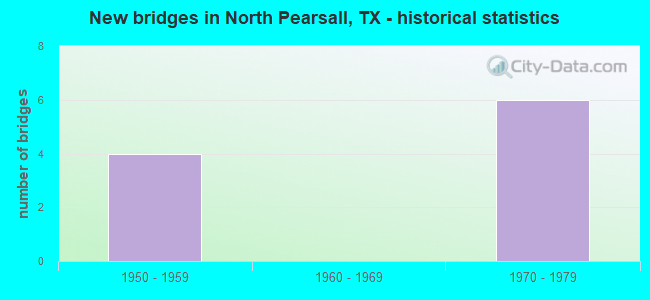
- New bridges - historical statistics
- 41950-1959
- 61970-1979


- Bridge Condition - Culverts
- 66.7%Good
- 33.3%Satisfactory
Find on map >> Show street view
Structure Number: 150830001706073, Location: 6.47 MI N OF FM 140 (Lat: 28.983553, Lng: -99.068725), Route carried "on" structure: Interstate 35, Year Built: 1950, Year Reconstructed: 1968, Status: Open, Structure Length: 1.46m (4.79ft), Average Daily Traffic: 21,294 (year 2020), Truck Traffic: 19%, Average Future Daily Traffic: 39,420 (year 2033), Design Load: H 15, Features Intersected: DRAW
Minimum Vertical Clearance: 30+ m (98+ ft), Kilometerpoint: 40.663, Lanes on structure: 8, Base Highway Network: Yes, Owner: State Highway Agency, Approaching Roadway Width: 43.9m (144.0ft), Skew: 29 degrees, Material/Design: Concrete, Design/Construction: Culvert, Number Of Spans In Main Unit: 6, Length of Maximum Span: 1.5m (4.9ft)
Condition: Channel: Good, Culverts: Good, Operating Rating: 39.9 metric tons, Method Used To Determine Operating Rating: Load Factor (LF), Inventory Rating: 23.6 metric tons, Method Used To Determine Inventory Rating: Load Factor (LF), Structural Evaluation: Somewhat better than minimum adequacy, Waterway Adequacy: Equal to present minimum criteria, Approach Roadway Alignment: Equal to present desirable criteria, Designated Inspection Frequency: Every 24 months, Inspection Date: July 2020
Find on map >> Show street view
Structure Number: 150830001706074, Location: 5.56 MI N OF FM 140 (Lat: 28.971000, Lng: -99.074161), Route carried "on" structure: Interstate 35, Year Built: 1950, Year Reconstructed: 1968, Status: Open, Structure Length: 1.04m (3.41ft), Average Daily Traffic: 21,294 (year 2020), Truck Traffic: 19%, Average Future Daily Traffic: 39,420 (year 2033), Design Load: H 15, Features Intersected: DRAW
Minimum Vertical Clearance: 30+ m (98+ ft), Kilometerpoint: 39.199, Lanes on structure: 8, Owner: State Highway Agency, Approaching Roadway Width: 43.9m (144.0ft), Skew: 20 degrees, Material/Design: Concrete, Design/Construction: Culvert, Number Of Spans In Main Unit: 6, Length of Maximum Span: 1.5m (4.9ft)
Condition: Channel: Good, Culverts: Satisfactory, Operating Rating: 39.9 metric tons, Method Used To Determine Operating Rating: Load Factor (LF), Inventory Rating: 23.6 metric tons, Method Used To Determine Inventory Rating: Load Factor (LF), Structural Evaluation: Somewhat better than minimum adequacy, Waterway Adequacy: Equal to present minimum criteria, Approach Roadway Alignment: Equal to present desirable criteria, Designated Inspection Frequency: Every 24 months, Inspection Date: July 2020
Find on map >> Show street view
Structure Number: 150830001706242, Location: 6.13 MI N OF FM 140 (Lat: 28.978997, Lng: -99.070681), Route carried "on" structure: Interstate 35, Year Built: 1950, Year Reconstructed: 1968, Status: Open, Structure Length: 0.73m (2.40ft), Average Daily Traffic: 21,294 (year 2020), Truck Traffic: 19%, Average Future Daily Traffic: 39,420 (year 2033), Design Load: H 15, Features Intersected: DRAW
Minimum Vertical Clearance: 30+ m (98+ ft), Kilometerpoint: 40.121, Lanes on structure: 8, Owner: State Highway Agency, Approaching Roadway Width: 43.9m (144.0ft), Skew: 29 degrees, Material/Design: Concrete, Design/Construction: Culvert, Number Of Spans In Main Unit: 3, Length of Maximum Span: 1.5m (4.9ft)
Condition: Channel: Good, Culverts: Satisfactory, Operating Rating: 39.9 metric tons, Method Used To Determine Operating Rating: Load Factor (LF), Inventory Rating: 23.6 metric tons, Method Used To Determine Inventory Rating: Load Factor (LF), Structural Evaluation: Somewhat better than minimum adequacy, Waterway Adequacy: Equal to present minimum criteria, Approach Roadway Alignment: Equal to present desirable criteria, Designated Inspection Frequency: Every 24 months, Inspection Date: July 2020
Find on map >> Show street view
Structure Number: 150830001706248, Location: 3.46 MI N OF FM 140 (Lat: 28.942781, Lng: -99.085425), Route carried "on" structure: Interstate 35, Year Built: 1973, Status: Open, Structure Length: 7.01m (23.00ft), Average Daily Traffic: 9,382 (year 2019), Truck Traffic: 20%, Average Future Daily Traffic: 18,660 (year 2033), Design Load: HS 20, Features Intersected: IH 35 BUSINESS E
Minimum Vertical Clearance: 30+ m (98+ ft), Kilometerpoint: 35.818, Lanes on structure: 2, Lanes under structure: 4, Base Highway Network: Yes, Owner: State Highway Agency, Approaching Roadway Width: 12.2m (40.0ft), Skew: 3 degrees, Material/Design: Prestressed concrete, Design/Construction: Stringer/Multi-beam, Number Of Spans In Main Unit: 2, Number Of Approach Spans: 2, Length of Maximum Span: 21.3m (69.9ft), Curb-To-Curb Width: 12.2m (40.0ft), Out-to-Out Width: 12.9m (42.3ft)
Condition: Deck: Very good, Superstructure: Very good, Substructure: Good, Operating Rating: 54.4 metric tons, Method Used To Determine Operating Rating: Assigned rating based on Load Factor Design (LFD) reported in metric tons, Inventory Rating: 32.7 metric tons, Method Used To Determine Inventory Rating: Assigned rating based on Load Factor Design (LFD) reported in metric tons, Structural Evaluation: Better than present minimum criteria, Deck Geometry: Better than present minimum criteria, Underclear: Superior to present desirable criteria, Approach Roadway Alignment: Equal to present desirable criteria, Designated Inspection Frequency: Every 24 months, Inspection Date: July 2020, Deck Structure Type: Concrete Cast-file-Place, Wearing Surface/Protective System: Wearing Surface: Bituminous
Find on map >> Show street view
Structure Number: 150830001706249, Location: 3.46 MI N OF FM 140 (Lat: 28.942681, Lng: -99.085386), Route carried "on" structure: Interstate 35, Year Built: 1973, Status: Open, Structure Length: 7.01m (23.00ft), Average Daily Traffic: 15,094 (year 2019), Truck Traffic: 20%, Average Future Daily Traffic: 18,660 (year 2033), Design Load: HS 20, Features Intersected: IH 35 BUSINESS E
Minimum Vertical Clearance: 30+ m (98+ ft), Kilometerpoint: 35.818, Lanes on structure: 2, Lanes under structure: 4, Base Highway Network: Yes, Owner: State Highway Agency, Approaching Roadway Width: 12.2m (40.0ft), Skew: 3 degrees, Material/Design: Prestressed concrete, Design/Construction: Stringer/Multi-beam, Number Of Spans In Main Unit: 2, Number Of Approach Spans: 2, Length of Maximum Span: 21.3m (69.9ft), Curb-To-Curb Width: 12.2m (40.0ft), Out-to-Out Width: 12.9m (42.3ft)
Condition: Deck: Very good, Superstructure: Very good, Substructure: Good, Operating Rating: 54.4 metric tons, Method Used To Determine Operating Rating: Assigned rating based on Load Factor Design (LFD) reported in metric tons, Inventory Rating: 32.7 metric tons, Method Used To Determine Inventory Rating: Assigned rating based on Load Factor Design (LFD) reported in metric tons, Structural Evaluation: Better than present minimum criteria, Deck Geometry: Better than present minimum criteria, Underclear: Superior to present desirable criteria, Approach Roadway Alignment: Equal to present desirable criteria, Designated Inspection Frequency: Every 24 months, Inspection Date: July 2020, Deck Structure Type: Concrete Cast-file-Place, Wearing Surface/Protective System: Wearing Surface: Bituminous
Find on map >> Show street view
Structure Number: 15083000170625, Location: 1.50 Mi N of FM 140 (Lat: 28.919492, Lng: -99.104931), Route carried "on" structure: Interstate 35, Year Built: 1973, Status: Open, Structure Length: 1.31m (4.30ft), Average Daily Traffic: 17,397 (year 2020), Truck Traffic: 20%, Average Future Daily Traffic: 37,330 (year 2033), Design Load: HS 20, Features Intersected: Draw
Minimum Vertical Clearance: 30+ m (98+ ft), Kilometerpoint: 32.649, Lanes on structure: 6, Base Highway Network: Yes, Owner: State Highway Agency, Approaching Roadway Width: 29.3m (96.1ft), Skew: 20 degrees, Material/Design: Concrete, Design/Construction: Culvert, Number Of Spans In Main Unit: 5, Length of Maximum Span: 2.4m (7.9ft)
Condition: Channel: Good, Culverts: Good, Operating Rating: 39.9 metric tons, Method Used To Determine Operating Rating: Load Factor (LF), Inventory Rating: 23.6 metric tons, Method Used To Determine Inventory Rating: Load Factor (LF), Structural Evaluation: Somewhat better than minimum adequacy, Waterway Adequacy: Equal to present minimum criteria, Approach Roadway Alignment: Equal to present desirable criteria, Designated Inspection Frequency: Every 48 months, Inspection Date: July 2018
Find on map >> Show street view
Structure Number: 150830001706302, Location: 1.10 Mi N of FM 140 (Lat: 28.914464, Lng: -99.108567), Route carried "on" structure: Interstate 35, Year Built: 1973, Status: Open, Structure Length: 0.73m (2.40ft), Average Daily Traffic: 17,397 (year 2020), Truck Traffic: 20%, Average Future Daily Traffic: 37,330 (year 2033), Design Load: HS 20, Features Intersected: Draw
Minimum Vertical Clearance: 30+ m (98+ ft), Kilometerpoint: 31.995, Lanes on structure: 6, Base Highway Network: Yes, Owner: State Highway Agency, Approaching Roadway Width: 29.3m (96.1ft), Skew: 29 degrees, Material/Design: Concrete, Design/Construction: Culvert, Number Of Spans In Main Unit: 3, Length of Maximum Span: 1.5m (4.9ft)
Condition: Channel: Good, Culverts: Good, Operating Rating: 39.9 metric tons, Method Used To Determine Operating Rating: Load Factor (LF), Inventory Rating: 23.6 metric tons, Method Used To Determine Inventory Rating: Load Factor (LF), Structural Evaluation: Somewhat better than minimum adequacy, Waterway Adequacy: Equal to present minimum criteria, Approach Roadway Alignment: Equal to present desirable criteria, Designated Inspection Frequency: Every 48 months, Inspection Date: July 2018
Find on map >> Show street view
Structure Number: 150830001715075, Location: 1.50 MI S OF IH 35 (Lat: 28.921461, Lng: -99.086539), Route carried "on" structure: Business State highway 35, Year Built: 1950, Status: Open, Structure Length: 0.88m (2.89ft), Average Daily Traffic: 1,250 (year 2013), Truck Traffic: 14%, Average Future Daily Traffic: 1,750 (year 2033), Design Load: H 15, Features Intersected: DRAW
Minimum Vertical Clearance: 30+ m (98+ ft), Kilometerpoint: 2.483, Lanes on structure: 2, Owner: State Highway Agency, Approaching Roadway Width: 12.8m (42.0ft), Material/Design: Concrete, Design/Construction: Culvert, Number Of Spans In Main Unit: 5, Length of Maximum Span: 1.5m (4.9ft), Curb-To-Curb Width: 15.2m (49.9ft), Out-to-Out Width: 16.0m (52.5ft)
Condition: Channel: Good, Culverts: Good, Operating Rating: 39.9 metric tons, Method Used To Determine Operating Rating: Load Factor (LF), Inventory Rating: 23.6 metric tons, Method Used To Determine Inventory Rating: Load Factor (LF), Structural Evaluation: Equal to present minimum criteria, Deck Geometry: Superior to present desirable criteria, Waterway Adequacy: Equal to present minimum criteria, Approach Roadway Alignment: Equal to present desirable criteria, Designated Inspection Frequency: Every 24 months, Inspection Date: July 2020, Deck Structure Type: Concrete Cast-file-Place, Wearing Surface/Protective System: Wearing Surface: Bituminous
Find on map >> Show street view
Structure Number: 150830001706248, Location: 3.46 MI N OF FM 140 (Lat: 28.942781, Lng: -99.085425), Route carried "under" structure: Business State highway 35, Year Built: 1973, Structure Length: 0. m, Average Daily Traffic: 1,250 (year 2013), Truck Traffic: 14%, Features Intersected: IH 35 BUSINESS E
Minimum Vertical Clearance: 5.51m (18.08ft), Kilometerpoint: 0.082, Lanes on structure: 2, Lanes under structure: 4, Material/Design: Prestressed concrete, Design/Construction: Stringer/Multi-beam, Length of Maximum Span: 21.3m (69.9ft)
Find on map >> Show street view
Structure Number: 150830001706249, Location: 3.46 MI N OF FM 140 (Lat: 28.942681, Lng: -99.085386), Route carried "under" structure: Business State highway 35, Year Built: 1973, Structure Length: 0. m, Average Daily Traffic: 1,250 (year 2013), Truck Traffic: 14%, Features Intersected: IH 35 BUSINESS E
Minimum Vertical Clearance: 5.41m (17.75ft), Kilometerpoint: 0.114, Lanes on structure: 2, Lanes under structure: 4, Material/Design: Prestressed concrete, Design/Construction: Stringer/Multi-beam, Length of Maximum Span: 21.3m (69.9ft)