Bridge Statistics for North East, New York (NY)
Condition, Traffic, Stress, Structural Evaluation, Project Costs
- National Bridge Inventory (NBI) Statistics
- 11Number of bridges
- 33ft / 9.7mTotal length
- $4,790,000Total costs
- 2,820Total average daily traffic
- 143Total average daily truck traffic
- National Bridge Inventory (NBI) Registered Bridges for North East
- No street view available for this location
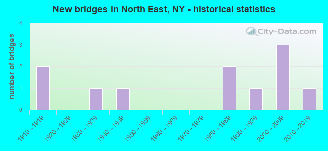
- New bridges - historical statistics
- 21910-1919
- 11930-1939
- 11940-1949
- 21980-1989
- 11990-1999
- 32000-2009
- 12010-2019

- Bridge Condition - Deck
- 20.0%Very good
- 40.0%Good
- 40.0%Satisfactory

- Bridge Condition - Superstructure
- 20.0%Very good
- 20.0%Good
- 40.0%Satisfactory
- 20.0%Fair

- Bridge Condition - Substructure
- 20.0%Excellent
- 20.0%Very good
- 40.0%Good
- 20.0%Satisfactory

- Bridge Condition - Channel
- 11.1%Good
- 33.3%Satisfactory
- 33.3%Fair
- 22.2%Poor

- Bridge Condition - Culverts
- 25.0%Good
- 25.0%Satisfactory
- 25.0%Fair
- 25.0%Poor
Find on map >> Show street view
Structure Number: 334301, Location: .1 MI N RT82A (Lat: 41.942886, Lng: -73.602394), Route carried "on" structure: County highway , Year Built: 1982, Status: Open, Structure Length: 0.70m (2.30ft), Average Daily Traffic: 489 (year 2020), Truck Traffic: 8%, Average Future Daily Traffic: 685 (year 2040), Design Load: HS 20, Features Intersected: BEAN RIVER, Facility Carried by Structure: COUNTY ROAD 83
Minimum Vertical Clearance: 30+ m (98+ ft), Kilometerpoint: 13.483, Lanes on structure: 2, Owner: County Highway Agency, Approaching Roadway Width: 6.7m (22.0ft), Material/Design: Concrete, Design/Construction: Culvert, Number Of Spans In Main Unit: 2, Length of Maximum Span: 3.0m (9.8ft), Curb-To-Curb Width: 9.0m (29.5ft), Out-to-Out Width: 9.8m (32.2ft)
Condition: Channel: Fair, Culverts: Fair, Operating Rating: 74.8 metric tons, Method Used To Determine Operating Rating: Field evaluation and documented engineering judgment, Inventory Rating: 32.7 metric tons, Method Used To Determine Inventory Rating: Field evaluation and documented engineering judgment, Structural Evaluation: Somewhat better than minimum adequacy, Deck Geometry: Somewhat better than minimum adequacy, Waterway Adequacy: Meets minimum limits, Approach Roadway Alignment: Equal to present desirable criteria, Length Of Structure Improvement: 0.70m (2.30ft), Designated Inspection Frequency: Every 24 months, Inspection Date: July 2021, Bridge Improvement Cost: $193,000, Roadway Improvement Cost: $113,000, Total Project Cost: $305,000 ( Estimate for 2021), Wearing Surface/Protective System: Wearing Surface: Bituminous
Find on map >> Show street view
Structure Number: 334337, Location: AT MT. RIGAA (Lat: 41.993669, Lng: -73.512506), Route carried "on" structure: County highway , Year Built: 1940, Status: Posted for load, Structure Length: 0.91m (2.99ft), Average Daily Traffic: 470 (year 2016), Truck Traffic: 4%, Average Future Daily Traffic: 658 (year 2036), Features Intersected: WEBATUCK CREEK, Facility Carried by Structure: COUNTY ROAD 62
Minimum Vertical Clearance: 30+ m (98+ ft), Kilometerpoint: 8.801, Lanes on structure: 2, Owner: County Highway Agency, Approaching Roadway Width: 6.7m (22.0ft), Material/Design: Concrete continuous, Design/Construction: Culvert, Number Of Spans In Main Unit: 2, Length of Maximum Span: 4.2m (13.8ft)
Condition: Channel: Poor, Culverts: Poor, Operating Rating: 28.1 metric tons, Method Used To Determine Operating Rating: Load Factor (LF), Inventory Rating: 16.3 metric tons, Method Used To Determine Inventory Rating: Load Factor (LF), Structural Evaluation: Meets minimum limits, Waterway Adequacy: Better than present minimum criteria, Approach Roadway Alignment: Equal to present minimum criteria, Bridge Posting: Required (Relationship of Operating Rating to Maximum Legal Load: > 39.9% below), Length Of Structure Improvement: 0.91m (2.99ft), Designated Inspection Frequency: Every 12 months, Inspection Date: June 2021, Bridge Improvement Cost: $200,000, Roadway Improvement Cost: $117,000, Total Project Cost: $318,000 ( Estimate for 2021)
Find on map >> Show street view
Structure Number: 334339, Location: 1.1 MI NW OF SHEKOMEKO (Lat: 41.943997, Lng: -73.600783), Route carried "on" structure: County highway , Year Built: 1980, Status: Open, Structure Length: 0.88m (2.89ft), Average Daily Traffic: 105 (year 2020), Truck Traffic: 6%, Average Future Daily Traffic: 147 (year 2040), Design Load: HS 20, Features Intersected: TRIBUTARY TO BEAN RIVER, Facility Carried by Structure: COUNTY ROAD 59
Minimum Vertical Clearance: 30+ m (98+ ft), Kilometerpoint: 0.064, Lanes on structure: 2, Owner: County Highway Agency, Approaching Roadway Width: 6.1m (20.0ft), Material/Design: Prestressed concrete, Design/Construction: Box Beam or Girders - Multiple, Number Of Spans In Main Unit: 1, Length of Maximum Span: 7.9m (25.9ft), Curb-To-Curb Width: 7.1m (23.3ft), Out-to-Out Width: 7.3m (24.0ft)
Condition: Deck: Good, Superstructure: Satisfactory, Substructure: Satisfactory, Channel: Fair, Operating Rating: 78.2 metric tons, Method Used To Determine Operating Rating: Field evaluation and documented engineering judgment, Inventory Rating: 32.7 metric tons, Method Used To Determine Inventory Rating: Field evaluation and documented engineering judgment, Structural Evaluation: Equal to present minimum criteria, Deck Geometry: Meets minimum limits, Waterway Adequacy: Meets minimum limits, Approach Roadway Alignment: Meets minimum limits, Length Of Structure Improvement: 0.88m (2.89ft), Designated Inspection Frequency: Every 24 months, Inspection Date: July 2021, Bridge Improvement Cost: $236,000, Roadway Improvement Cost: $138,000, Total Project Cost: $373,000 ( Estimate for 2021), Wearing Surface/Protective System: Wearing Surface: Bituminous
Find on map >> Show street view
Structure Number: 33434, Location: 2.1 MI S OF NORTHEAST CTR (Lat: 41.902219, Lng: -73.536144), Route carried "on" structure: County highway , Year Built: 1939, Status: Open, Structure Length: 0.94m (3.08ft), Average Daily Traffic: 383 (year 2020), Truck Traffic: 7%, Average Future Daily Traffic: 536 (year 2040), Design Load: H 20, Features Intersected: TRIB WEBATUCK CREEK, Facility Carried by Structure: COUNTY ROAD 58
Minimum Vertical Clearance: 30+ m (98+ ft), Kilometerpoint: 0.113, Lanes on structure: 2, Owner: County Highway Agency, Approaching Roadway Width: 6.1m (20.0ft), Skew: 3 degrees, Material/Design: Concrete continuous, Design/Construction: Culvert, Number Of Spans In Main Unit: 2, Length of Maximum Span: 3.9m (12.8ft), Curb-To-Curb Width: 6.7m (22.0ft), Out-to-Out Width: 7.8m (25.6ft)
Condition: Channel: Fair, Culverts: Satisfactory, Operating Rating: 35.0 metric tons, Method Used To Determine Operating Rating: Load and Resistance Factor Rating (LRFR) rating reported by rating factor(RF) method using HL-93 loadings, Inventory Rating: 26.9 metric tons, Method Used To Determine Inventory Rating: Load and Resistance Factor Rating (LRFR) rating reported by rating factor(RF) method using HL-93 loadings, Structural Evaluation: Equal to present minimum criteria, Deck Geometry: Meets minimum limits, Waterway Adequacy: Meets minimum limits, Approach Roadway Alignment: Equal to present minimum criteria, Length Of Structure Improvement: 0.94m (3.08ft), Designated Inspection Frequency: Every 24 months, Inspection Date: September 2021, Bridge Improvement Cost: $209,000, Roadway Improvement Cost: $122,000, Total Project Cost: $331,000 ( Estimate for 2021)
Find on map >> Show street view
Structure Number: 334341, Location: 0.8 MI E of Rt.44 (Lat: 41.905089, Lng: -73.525006), Route carried "on" structure: County highway , Year Built: 2011, Status: Open, Structure Length: 1.22m (4.00ft), Average Daily Traffic: 383 (year 2020), Truck Traffic: 7%, Average Future Daily Traffic: 536 (year 2040), Design Load: HS 25 or greater, Features Intersected: MOUNTAIN CREEK, Facility Carried by Structure: CR58 COLEMAN STAT
Minimum Vertical Clearance: 30+ m (98+ ft), Kilometerpoint: 1.158, Lanes on structure: 2, Owner: County Highway Agency, Approaching Roadway Width: 9.1m (29.9ft), Skew: 3 degrees, Material/Design: Concrete, Design/Construction: Frame, Number Of Spans In Main Unit: 1, Length of Maximum Span: 11.0m (36.1ft), Curb-To-Curb Width: 9.0m (29.5ft), Out-to-Out Width: 10.0m (32.8ft)
Condition: Deck: Very good, Superstructure: Very good, Substructure: Excellent, Channel: Satisfactory, Operating Rating: 75.3 metric tons, Method Used To Determine Operating Rating: Load Factor (LF), Inventory Rating: 45.4 metric tons, Method Used To Determine Inventory Rating: Load Factor (LF), Structural Evaluation: Equal to present desirable criteria, Deck Geometry: Equal to present minimum criteria, Waterway Adequacy: Somewhat better than minimum adequacy, Approach Roadway Alignment: Equal to present desirable criteria, Length Of Structure Improvement: 1.21m (3.97ft), Designated Inspection Frequency: Every 24 months, Inspection Date: September 2021, Bridge Improvement Cost: $637,000, Roadway Improvement Cost: $373,000, Total Project Cost: $1,010,000 ( Estimate for 2021), Wearing Surface/Protective System: Wearing Surface: Bituminous
Find on map >> Show street view
Structure Number: 334342, Location: 2 MI N JCT US44 & CO RD 1 (Lat: 41.906286, Lng: -73.520564), Route carried "on" structure: County highway , Year Built: 2002, Status: Open, Structure Length: 0.76m (2.49ft), Average Daily Traffic: 168 (year 2020), Truck Traffic: 1%, Average Future Daily Traffic: 235 (year 2040), Design Load: HS 25 or greater, Features Intersected: WEBATUCK CREEK TRIBUTAR, Facility Carried by Structure: COUNTY ROAD 61
Minimum Vertical Clearance: 30+ m (98+ ft), Kilometerpoint: 0.274, Lanes on structure: 2, Owner: County Highway Agency, Approaching Roadway Width: 9.1m (29.9ft), Skew: 2 degrees, Material/Design: Concrete, Design/Construction: Culvert, Number Of Spans In Main Unit: 1, Length of Maximum Span: 6.7m (22.0ft)
Condition: Channel: Poor, Culverts: Good, Operating Rating: 77.3 metric tons, Method Used To Determine Operating Rating: Field evaluation and documented engineering judgment, Inventory Rating: 40.8 metric tons, Method Used To Determine Inventory Rating: Field evaluation and documented engineering judgment, Structural Evaluation: Better than present minimum criteria, Waterway Adequacy: Meets minimum limits, Approach Roadway Alignment: Equal to present desirable criteria, Length Of Structure Improvement: 0.76m (2.49ft), Designated Inspection Frequency: Every 24 months, Inspection Date: August 2021, Bridge Improvement Cost: $196,000, Roadway Improvement Cost: $115,000, Total Project Cost: $311,000 ( Estimate for 2021)
Find on map >> Show street view
Structure Number: 334343, Location: 2.2 MI SE OF NORTHEAST CT (Lat: 41.907944, Lng: -73.507078), Route carried "on" structure: County highway , Year Built: 1992, Status: Open, Structure Length: 1.34m (4.40ft), Average Daily Traffic: 96 (year 2020), Truck Traffic: 1%, Average Future Daily Traffic: 134 (year 2040), Design Load: HS 25 or greater, Features Intersected: WEBATUCK CREEK, Facility Carried by Structure: REAGAN ROAD
Minimum Vertical Clearance: 30+ m (98+ ft), Kilometerpoint: 1.175, Lanes on structure: 2, Owner: County Highway Agency, Approaching Roadway Width: 7.3m (24.0ft), Material/Design: Prestressed concrete, Design/Construction: Box Beam or Girders - Multiple, Number Of Spans In Main Unit: 1, Length of Maximum Span: 12.8m (42.0ft), Curb-To-Curb Width: 8.1m (26.6ft), Out-to-Out Width: 8.7m (28.5ft)
Condition: Deck: Satisfactory, Superstructure: Fair, Substructure: Good, Channel: Good, Operating Rating: 91.7 metric tons, Method Used To Determine Operating Rating: Load and Resistance Factor Rating (LRFR) rating reported by rating factor(RF) method using HL-93 loadings, Inventory Rating: 70.6 metric tons, Method Used To Determine Inventory Rating: Load and Resistance Factor Rating (LRFR) rating reported by rating factor(RF) method using HL-93 loadings, Structural Evaluation: Somewhat better than minimum adequacy, Deck Geometry: Equal to present minimum criteria, Waterway Adequacy: Somewhat better than minimum adequacy, Approach Roadway Alignment: Meets minimum limits, Length Of Structure Improvement: 1.34m (4.40ft), Designated Inspection Frequency: Every 24 months, Inspection Date: June 2021, Bridge Improvement Cost: $540,000, Roadway Improvement Cost: $316,000, Total Project Cost: $856,000 ( Estimate for 2021), Wearing Surface/Protective System: Wearing Surface: Integral Concrete
Find on map >> Show street view
Structure Number: 334344, Location: W OF INDIAN LK-NW CT BRDR (Lat: 41.914725, Lng: -73.514814), Route carried "on" structure: County highway , Year Built: 2001, Status: Open, Structure Length: 1.58m (5.18ft), Average Daily Traffic: 168 (year 2020), Truck Traffic: 1%, Average Future Daily Traffic: 235 (year 2040), Design Load: HS 25 or greater, Features Intersected: WEBATUCK CREEK, Facility Carried by Structure: INDIAN LAKE ROAD
Minimum Vertical Clearance: 30+ m (98+ ft), Kilometerpoint: 1.400, Lanes on structure: 2, Owner: County Highway Agency, Approaching Roadway Width: 7.3m (24.0ft), Skew: 1 degrees, Material/Design: Prestressed concrete, Design/Construction: Box Beam or Girders - Multiple, Number Of Spans In Main Unit: 1, Length of Maximum Span: 15.1m (49.5ft), Curb-To-Curb Width: 7.3m (24.0ft), Out-to-Out Width: 7.9m (25.9ft)
Condition: Deck: Satisfactory, Superstructure: Satisfactory, Substructure: Good, Channel: Satisfactory, Operating Rating: 78.0 metric tons, Method Used To Determine Operating Rating: Load Factor (LF), Inventory Rating: 42.6 metric tons, Method Used To Determine Inventory Rating: Load Factor (LF), Structural Evaluation: Equal to present minimum criteria, Deck Geometry: Somewhat better than minimum adequacy, Waterway Adequacy: Equal to present desirable criteria, Approach Roadway Alignment: Equal to present desirable criteria, Length Of Structure Improvement: 1.58m (5.18ft), Designated Inspection Frequency: Every 24 months, Inspection Date: March 2020, Bridge Improvement Cost: $333,000, Roadway Improvement Cost: $195,000, Total Project Cost: $529,000 ( Estimate for 2021), Wearing Surface/Protective System: Wearing Surface: Monolithic Concrete
Find on map >> Show street view
Structure Number: 334345, Location: W OF INDIAN LAKE OFF CR61 (Lat: 41.925969, Lng: -73.510828), Route carried "on" structure: Other road , Year Built: 2001, Status: Open, Structure Length: 1.34m (4.40ft), Average Daily Traffic: 279 (year 2020), Truck Traffic: 5%, Average Future Daily Traffic: 391 (year 2040), Design Load: HS 25 or greater, Features Intersected: WEBATUCK CREEK, Facility Carried by Structure: DOWNEY ROAD
Minimum Vertical Clearance: 30+ m (98+ ft), Kilometerpoint: 2.333, Lanes on structure: 2, Owner: County Highway Agency, Approaching Roadway Width: 6.7m (22.0ft), Material/Design: Concrete, Design/Construction: Frame, Number Of Spans In Main Unit: 1, Length of Maximum Span: 12.8m (42.0ft), Curb-To-Curb Width: 6.6m (21.7ft), Out-to-Out Width: 7.3m (24.0ft)
Condition: Deck: Good, Superstructure: Good, Substructure: Very good, Channel: Satisfactory, Operating Rating: 70.8 metric tons, Method Used To Determine Operating Rating: Load Factor (LF), Inventory Rating: 42.6 metric tons, Method Used To Determine Inventory Rating: Load Factor (LF), Structural Evaluation: Better than present minimum criteria, Deck Geometry: Meets minimum limits, Waterway Adequacy: Better than present minimum criteria, Approach Roadway Alignment: Equal to present desirable criteria, Length Of Structure Improvement: 1.34m (4.40ft), Designated Inspection Frequency: Every 24 months, Inspection Date: March 2020, Bridge Improvement Cost: $477,000, Roadway Improvement Cost: $279,000, Total Project Cost: $757,000 ( Estimate for 2021), Wearing Surface/Protective System: Wearing Surface: Bituminous, Membrane: Other
Find on map >> Show street view
Structure Number: 771312, Location: 1.3 MI SE OF NRTHEST CNTR (Lat: 41.917803, Lng: -73.517514), Route carried "under" structure: Other road , Year Built: 1912, Structure Length: 0. m, Features Intersected: MILL ROAD, UNNAMED STREA, Facility Carried by Structure: EX-N Y CENTRAL RR
Minimum Vertical Clearance: 4.11m (13.48ft), Kilometerpoint: 0.000, Lanes under structure: 2, Material/Design: Steel, Design/Construction: Stringer/Multi-beam, Length of Maximum Span: 10.0m (32.8ft)
Find on map >> Show street view
Structure Number: 771313, Location: 1.0 MI E OF NORTHEAST CNR (Lat: 41.927269, Lng: -73.514469), Route carried "under" structure: Other road , Year Built: 1912, Structure Length: 0. m, Average Daily Traffic: 279 (year 2020), Truck Traffic: 5%, Features Intersected: DOWNEY ROAD, Facility Carried by Structure: EX-N Y CENTRAL RR
Minimum Vertical Clearance: 4.01m (13.16ft), Kilometerpoint: 0.000, Lanes under structure: 2, Material/Design: Steel, Design/Construction: Stringer/Multi-beam, Length of Maximum Span: 7.6m (24.9ft)