Bridge Statistics for Newton, Alabama (AL)
Condition, Traffic, Stress, Structural Evaluation, Project Costs
- National Bridge Inventory (NBI) Statistics
- 28Number of bridges
- 571ft / 174mTotal length
- $51,698,000Total costs
- 69,787Total average daily traffic
- 8,554Total average daily truck traffic
- 94,998Total future (year 2033) average daily traffic
- National Bridge Inventory (NBI) Registered Bridges for Newton
- No street view available for this location
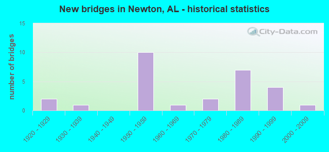
- New bridges - historical statistics
- 21920-1929
- 11930-1939
- 101950-1959
- 11960-1969
- 21970-1979
- 71980-1989
- 41990-1999
- 12000-2009


- Bridge Condition - Deck
- 4.8%Excellent
- 14.3%Very good
- 38.1%Good
- 33.3%Satisfactory
- 9.5%Fair

- Bridge Condition - Superstructure
- 4.8%Excellent
- 19.0%Very good
- 52.4%Good
- 23.8%Satisfactory

- Bridge Condition - Substructure
- 4.8%Excellent
- 14.3%Very good
- 57.1%Good
- 23.8%Satisfactory

- Bridge Condition - Channel
- 21.4%Very good
- 50.0%Good
- 25.0%Satisfactory
- 3.6%Fair

- Bridge Condition - Culverts
- 14.3%Very good
- 42.9%Good
- 28.6%Satisfactory
- 14.3%Fair
Find on map >> Show street view
Structure Number: 427, Location: 2.5 MI SE JCT I 59 (Lat: 34.569264, Lng: -85.616219), Route carried "on" structure: State highway 117, Year Built: 1927, Status: Open, Structure Length: 1.49m (4.89ft), Average Daily Traffic: 4,421 (year 2019), Truck Traffic: 8%, Average Future Daily Traffic: 6,189 (year 2039), Design Load: H 15, Features Intersected: WILLS CREEK
Minimum Vertical Clearance: 30+ m (98+ ft), Kilometerpoint: 15.104, Lanes on structure: 2, Owner: State Highway Agency, Approaching Roadway Width: 7.0m (23.0ft), Skew: 3 degrees, Material/Design: Concrete, Design/Construction: Culvert, Number Of Spans In Main Unit: 4, Length of Maximum Span: 3.0m (9.8ft)
Condition: Channel: Satisfactory, Culverts: Good, Operating Rating: 41.1 metric tons, Method Used To Determine Operating Rating: Load Factor (LF), Inventory Rating: 24.7 metric tons, Method Used To Determine Inventory Rating: Load Factor (LF), Structural Evaluation: Equal to present minimum criteria, Waterway Adequacy: Equal to present minimum criteria, Approach Roadway Alignment: Equal to present minimum criteria, Length Of Structure Improvement: 2.17m (7.12ft), Designated Inspection Frequency: Every 24 months, Inspection Date: March 2021, Bridge Improvement Cost: $326,000, Roadway Improvement Cost: $33,000, Total Project Cost: $359,000 ( Estimate for 2022), Wearing Surface/Protective System: Wearing Surface: Bituminous
Find on map >> Show street view
Structure Number: 669, Location: 6.1 MI. E. OF CHATOM (Lat: 31.442850, Lng: -88.159197), Route carried "on" structure: State highway 56, Year Built: 1929, Status: Open, Structure Length: 0.81m (2.66ft), Average Daily Traffic: 1,930 (year 2013), Truck Traffic: 21%, Average Future Daily Traffic: 2,465 (year 2033), Design Load: H 15, Features Intersected: BRANCH
Minimum Vertical Clearance: 30+ m (98+ ft), Kilometerpoint: 31.276, Lanes on structure: 2, Owner: State Highway Agency, Approaching Roadway Width: 10.4m (34.1ft), Material/Design: Concrete, Design/Construction: Culvert, Number Of Spans In Main Unit: 3, Length of Maximum Span: 2.4m (7.9ft)
Condition: Channel: Satisfactory, Culverts: Satisfactory, Operating Rating: 87.3 metric tons, Method Used To Determine Operating Rating: Load Factor (LF), Inventory Rating: 52.3 metric tons, Method Used To Determine Inventory Rating: Load Factor (LF), Structural Evaluation: Equal to present minimum criteria, Waterway Adequacy: Somewhat better than minimum adequacy, Approach Roadway Alignment: Better than present minimum criteria, Length Of Structure Improvement: 1.47m (4.82ft), Designated Inspection Frequency: Every 24 months, Inspection Date: January 2021, Bridge Improvement Cost: $271,000, Roadway Improvement Cost: $27,000, Total Project Cost: $298,000 ( Estimate for 2022)
Find on map >> Show street view
Structure Number: 1877, Location: .2 MI. NE POP. RIDGE RD(3 (Lat: 34.566661, Lng: -86.363239), Route carried "on" structure: County highway 537, Year Built: 1938, Status: Open, Structure Length: 0.85m (2.79ft), Average Daily Traffic: 825 (year 1992), Truck Traffic: 1%, Average Future Daily Traffic: 1,350 (year 2034), Design Load: H 15, Features Intersected: POND CREEK, Facility Carried by Structure: NEW HOPE CED PNT
Minimum Vertical Clearance: 30+ m (98+ ft), Kilometerpoint: 0.010, Lanes on structure: 2, Owner: County Highway Agency, Approaching Roadway Width: 7.9m (25.9ft), Material/Design: Masonry, Design/Construction: Culvert, Number Of Spans In Main Unit: 2, Length of Maximum Span: 4.3m (14.1ft), Curb-To-Curb Width: 6.9m (22.6ft), Out-to-Out Width: 7.3m (24.0ft)
Condition: Channel: Fair, Culverts: Fair, Operating Rating: 32.7 metric tons, Method Used To Determine Operating Rating: Field evaluation and documented engineering judgment, Inventory Rating: 23.6 metric tons, Method Used To Determine Inventory Rating: Field evaluation and documented engineering judgment, Structural Evaluation: Somewhat better than minimum adequacy, Deck Geometry: Meets minimum limits, Waterway Adequacy: Somewhat better than minimum adequacy, Approach Roadway Alignment: Better than present minimum criteria, Length Of Structure Improvement: 1.51m (4.95ft), Designated Inspection Frequency: Every 24 months, Inspection Date: May 2020, Bridge Improvement Cost: $210,000, Roadway Improvement Cost: $21,000, Total Project Cost: $231,000 ( Estimate for 2022)
Find on map >> Show street view
Structure Number: 4898, Location: SEC-27 T-5-N R-25-E (Lat: 31.374300, Lng: -85.522131), Route carried "on" structure: County highway 59, Year Built: 1954, Status: Open, Structure Length: 11.00m (36.09ft), Average Daily Traffic: 407 (year 2007), Truck Traffic: 9%, Average Future Daily Traffic: 605 (year 2034), Design Load: H 15, Features Intersected: EAST CHOCTAWHATCHEE R
Minimum Vertical Clearance: 7.56m (24.80ft), Kilometerpoint: 0.000, Lanes on structure: 2, Owner: County Highway Agency, Approaching Roadway Width: 9.1m (29.9ft), Material/Design: Concrete, Design/Construction: Tee Beam, Number Of Spans In Main Unit: 6, Length of Maximum Span: 27.4m (89.9ft), Curb-To-Curb Width: 6.7m (22.0ft), Out-to-Out Width: 7.6m (24.9ft)
Condition: Deck: Satisfactory, Superstructure: Satisfactory, Substructure: Good, Channel: Good, Operating Rating: 40.6 metric tons, Method Used To Determine Operating Rating: Load Factor (LF), Inventory Rating: 19.9 metric tons, Method Used To Determine Inventory Rating: Load Factor (LF), Structural Evaluation: Somewhat better than minimum adequacy, Deck Geometry: Meets minimum limits, Waterway Adequacy: Better than present minimum criteria, Approach Roadway Alignment: Better than present minimum criteria, Length Of Structure Improvement: 11.89m (39.01ft), Designated Inspection Frequency: Every 24 months, Inspection Date: October 2021, Bridge Improvement Cost: $1,957,000, Roadway Improvement Cost: $196,000, Total Project Cost: $2,153,000 ( Estimate for 2022), Deck Structure Type: Concrete Cast-file-Place
Find on map >> Show street view
Structure Number: 5487, Location: SEC-12 T-4-N R-24-E (Lat: 31.339286, Lng: -85.588347), Route carried "on" structure: County highway 14, Year Built: 1956, Status: Posted for load, Structure Length: 3.11m (10.20ft), Average Daily Traffic: 442 (year 2002), Truck Traffic: 11%, Average Future Daily Traffic: 657 (year 2034), Design Load: H 15, Features Intersected: KILLEBREW MILL CREEK
Minimum Vertical Clearance: 30+ m (98+ ft), Kilometerpoint: 0.000, Lanes on structure: 2, Owner: County Highway Agency, Approaching Roadway Width: 8.5m (27.9ft), Material/Design: Concrete, Design/Construction: Tee Beam, Number Of Spans In Main Unit: 3, Length of Maximum Span: 10.4m (34.1ft), Curb-To-Curb Width: 6.7m (22.0ft), Out-to-Out Width: 7.1m (23.3ft)
Condition: Deck: Satisfactory, Superstructure: Satisfactory, Substructure: Satisfactory, Channel: Good, Operating Rating: 35.7 metric tons, Method Used To Determine Operating Rating: Load Factor (LF), Inventory Rating: 21.4 metric tons, Method Used To Determine Inventory Rating: Load Factor (LF), Structural Evaluation: Equal to present minimum criteria, Deck Geometry: Meets minimum limits, Waterway Adequacy: Equal to present minimum criteria, Approach Roadway Alignment: Better than present minimum criteria, Bridge Posting: Required (Relationship of Operating Rating to Maximum Legal Load: 0.1 - 9.9% below), Length Of Structure Improvement: 3.96m (12.99ft), Designated Inspection Frequency: Every 24 months, Other Special Inspection Frequency: Every 12 months, Inspection Date: October 2021, Other Special Inspection Date: October 2021, Bridge Improvement Cost: $625,000, Roadway Improvement Cost: $63,000, Total Project Cost: $688,000 ( Estimate for 2022), Deck Structure Type: Concrete Cast-file-Place
Find on map >> Show street view
Structure Number: 5488, Location: SEC-3 T-4-N R-25-E (Lat: 31.354139, Lng: -85.533850), Route carried "on" structure: County highway 14, Year Built: 1956, Status: Posted for load, Structure Length: 4.15m (13.62ft), Average Daily Traffic: 442 (year 2002), Truck Traffic: 30%, Average Future Daily Traffic: 657 (year 2034), Design Load: H 15, Features Intersected: KELLY CREEK
Minimum Vertical Clearance: 7.56m (24.80ft), Kilometerpoint: 0.000, Lanes on structure: 2, Owner: County Highway Agency, Approaching Roadway Width: 8.5m (27.9ft), Material/Design: Concrete, Design/Construction: Tee Beam, Number Of Spans In Main Unit: 4, Length of Maximum Span: 10.4m (34.1ft), Curb-To-Curb Width: 6.7m (22.0ft), Out-to-Out Width: 7.1m (23.3ft)
Condition: Deck: Good, Superstructure: Good, Substructure: Satisfactory, Channel: Satisfactory, Operating Rating: 35.7 metric tons, Method Used To Determine Operating Rating: Load Factor (LF), Inventory Rating: 21.4 metric tons, Method Used To Determine Inventory Rating: Load Factor (LF), Structural Evaluation: Equal to present minimum criteria, Deck Geometry: Meets minimum limits, Waterway Adequacy: Equal to present minimum criteria, Approach Roadway Alignment: Better than present minimum criteria, Bridge Posting: Required (Relationship of Operating Rating to Maximum Legal Load: 0.1 - 9.9% below), Length Of Structure Improvement: 5.12m (16.80ft), Designated Inspection Frequency: Every 24 months, Other Special Inspection Frequency: Every 12 months, Inspection Date: March 2021, Other Special Inspection Date: March 2021, Bridge Improvement Cost: $807,000, Roadway Improvement Cost: $81,000, Total Project Cost: $888,000 ( Estimate for 2022), Deck Structure Type: Concrete Cast-file-Place
Find on map >> Show street view
Structure Number: 6327, Location: SEC-10 T-5-N R-25-E (Lat: 31.422428, Lng: -85.530806), Route carried "on" structure: County highway 59, Year Built: 1958, Status: Open, Structure Length: 1.55m (5.09ft), Average Daily Traffic: 1,400 (year 2007), Truck Traffic: 6%, Average Future Daily Traffic: 2,080 (year 2034), Design Load: H 15, Features Intersected: BIG CREEK
Minimum Vertical Clearance: 30+ m (98+ ft), Kilometerpoint: 0.000, Lanes on structure: 2, Owner: County Highway Agency, Approaching Roadway Width: 9.1m (29.9ft), Material/Design: Concrete, Design/Construction: Culvert, Number Of Spans In Main Unit: 4, Length of Maximum Span: 3.7m (12.1ft)
Condition: Channel: Satisfactory, Culverts: Satisfactory, Operating Rating: 47.2 metric tons, Method Used To Determine Operating Rating: Load Factor (LF), Inventory Rating: 28.3 metric tons, Method Used To Determine Inventory Rating: Load Factor (LF), Structural Evaluation: Equal to present minimum criteria, Waterway Adequacy: Equal to present minimum criteria, Approach Roadway Alignment: Better than present minimum criteria, Length Of Structure Improvement: 2.23m (7.32ft), Designated Inspection Frequency: Every 24 months, Inspection Date: November 2021, Bridge Improvement Cost: $516,000, Roadway Improvement Cost: $52,000, Total Project Cost: $568,000 ( Estimate for 2022)
Find on map >> Show street view
Structure Number: 6632, Location: 4.1 MI. N. SR 134 (Lat: 31.356800, Lng: -85.558533), Route carried "on" structure: US 231, Year Built: 1959, Status: Open, Structure Length: 13.14m (43.11ft), Average Daily Traffic: 8,850 (year 2013), Truck Traffic: 16%, Average Future Daily Traffic: 11,504 (year 2033), Design Load: HS 20, Features Intersected: CHOCTAWHATCHEE RIVER
Minimum Vertical Clearance: 30+ m (98+ ft), Kilometerpoint: 56.251, Lanes on structure: 2, Base Highway Network: Yes, Owner: State Highway Agency, Approaching Roadway Width: 12.2m (40.0ft), Material/Design: Concrete continuous, Design/Construction: Tee Beam, Number Of Spans In Main Unit: 3, Number Of Approach Spans: 5, Length of Maximum Span: 30.5m (100.1ft), Curb or Sidewalk Widths: Left: 0.5m (1.6ft), Right: 0.5m (1.6ft), Curb-To-Curb Width: 8.5m (27.9ft), Out-to-Out Width: 10.1m (33.1ft)
Condition: Deck: Fair, Superstructure: Satisfactory, Substructure: Good, Channel: Good, Operating Rating: 42.4 metric tons, Method Used To Determine Operating Rating: Load Factor (LF), Inventory Rating: 25.4 metric tons, Method Used To Determine Inventory Rating: Load Factor (LF), Structural Evaluation: Equal to present minimum criteria, Deck Geometry: High priority of corrective action, Waterway Adequacy: Equal to present desirable criteria, Approach Roadway Alignment: Equal to present desirable criteria, Length Of Structure Improvement: 13.96m (45.80ft), Designated Inspection Frequency: Every 24 months, Inspection Date: June 2020, Bridge Improvement Cost: $3,158,000, Roadway Improvement Cost: $316,000, Total Project Cost: $3,474,000 ( Estimate for 2022), Deck Structure Type: Concrete Cast-file-Place
Find on map >> Show street view
Structure Number: 6633, Location: 4.1 MI N.SR 134 (Lat: 31.356883, Lng: -85.558383), Route carried "on" structure: US 231, Year Built: 1959, Status: Open, Structure Length: 13.14m (43.11ft), Average Daily Traffic: 8,850 (year 2013), Truck Traffic: 16%, Average Future Daily Traffic: 11,504 (year 2033), Design Load: HS 20, Features Intersected: CHOCTAWHATCHEE RIVER
Minimum Vertical Clearance: 30+ m (98+ ft), Kilometerpoint: 56.251, Lanes on structure: 2, Base Highway Network: Yes, Owner: State Highway Agency, Approaching Roadway Width: 12.2m (40.0ft), Material/Design: Concrete continuous, Design/Construction: Tee Beam, Number Of Spans In Main Unit: 3, Number Of Approach Spans: 5, Length of Maximum Span: 30.5m (100.1ft), Curb or Sidewalk Widths: Left: 0.5m (1.6ft), Right: 0.5m (1.6ft), Curb-To-Curb Width: 8.5m (27.9ft), Out-to-Out Width: 10.1m (33.1ft)
Condition: Deck: Fair, Superstructure: Satisfactory, Substructure: Good, Channel: Satisfactory, Operating Rating: 42.4 metric tons, Method Used To Determine Operating Rating: Load Factor (LF), Inventory Rating: 25.4 metric tons, Method Used To Determine Inventory Rating: Load Factor (LF), Structural Evaluation: Equal to present minimum criteria, Deck Geometry: High priority of corrective action, Waterway Adequacy: Equal to present desirable criteria, Approach Roadway Alignment: Equal to present desirable criteria, Length Of Structure Improvement: 13.96m (45.80ft), Designated Inspection Frequency: Every 24 months, Inspection Date: June 2020, Bridge Improvement Cost: $3,158,000, Roadway Improvement Cost: $316,000, Total Project Cost: $3,474,000 ( Estimate for 2022), Deck Structure Type: Concrete Cast-file-Place
Find on map >> Show street view
Structure Number: 6634, Location: 4.4 MI. N. SR. 134 (Lat: 31.360583, Lng: -85.560672), Route carried "on" structure: US 231, Year Built: 1959, Status: Open, Structure Length: 8.29m (27.20ft), Average Daily Traffic: 8,850 (year 2013), Truck Traffic: 16%, Average Future Daily Traffic: 11,504 (year 2033), Design Load: HS 20, Features Intersected: CHOCTAWHATCHEE RIVER R.
Minimum Vertical Clearance: 30+ m (98+ ft), Kilometerpoint: 56.752, Lanes on structure: 2, Base Highway Network: Yes, Owner: State Highway Agency, Approaching Roadway Width: 13.1m (43.0ft), Skew: 10 degrees, Material/Design: Concrete, Design/Construction: Tee Beam, Number Of Spans In Main Unit: 8, Length of Maximum Span: 10.4m (34.1ft), Curb or Sidewalk Widths: Left: 0.5m (1.6ft), Right: 0.5m (1.6ft), Curb-To-Curb Width: 8.5m (27.9ft), Out-to-Out Width: 10.1m (33.1ft)
Condition: Deck: Satisfactory, Superstructure: Satisfactory, Substructure: Good, Channel: Good, Operating Rating: 48.3 metric tons, Method Used To Determine Operating Rating: Load Factor (LF), Inventory Rating: 28.9 metric tons, Method Used To Determine Inventory Rating: Load Factor (LF), Structural Evaluation: Equal to present minimum criteria, Deck Geometry: High priority of corrective action, Waterway Adequacy: Equal to present desirable criteria, Approach Roadway Alignment: Equal to present desirable criteria, Length Of Structure Improvement: 9.29m (30.48ft), Designated Inspection Frequency: Every 24 months, Inspection Date: June 2020, Bridge Improvement Cost: $2,102,000, Roadway Improvement Cost: $210,000, Total Project Cost: $2,312,000 ( Estimate for 2022), Deck Structure Type: Concrete Cast-file-Place
Find on map >> Show street view
Structure Number: 6635, Location: 4.4 MI. N. AL. 134 (Lat: 31.360667, Lng: -85.560500), Route carried "on" structure: US 231, Year Built: 1959, Status: Open, Structure Length: 8.29m (27.20ft), Average Daily Traffic: 8,850 (year 2013), Truck Traffic: 16%, Average Future Daily Traffic: 11,504 (year 2033), Design Load: HS 20, Features Intersected: CHOCTAWHATCHEE RIVER R.
Minimum Vertical Clearance: 30+ m (98+ ft), Kilometerpoint: 56.752, Lanes on structure: 2, Base Highway Network: Yes, Owner: State Highway Agency, Approaching Roadway Width: 13.1m (43.0ft), Skew: 10 degrees, Material/Design: Concrete, Design/Construction: Tee Beam, Number Of Spans In Main Unit: 8, Length of Maximum Span: 10.4m (34.1ft), Curb or Sidewalk Widths: Left: 0.5m (1.6ft), Right: 0.5m (1.6ft), Curb-To-Curb Width: 8.5m (27.9ft), Out-to-Out Width: 10.1m (33.1ft)
Condition: Deck: Satisfactory, Superstructure: Good, Substructure: Good, Channel: Good, Operating Rating: 48.3 metric tons, Method Used To Determine Operating Rating: Load Factor (LF), Inventory Rating: 28.9 metric tons, Method Used To Determine Inventory Rating: Load Factor (LF), Structural Evaluation: Better than present minimum criteria, Deck Geometry: High priority of corrective action, Waterway Adequacy: Equal to present desirable criteria, Approach Roadway Alignment: Equal to present desirable criteria, Length Of Structure Improvement: 9.29m (30.48ft), Designated Inspection Frequency: Every 24 months, Inspection Date: June 2020, Bridge Improvement Cost: $2,102,000, Roadway Improvement Cost: $210,000, Total Project Cost: $2,312,000 ( Estimate for 2022), Deck Structure Type: Concrete Cast-file-Place
Find on map >> Show street view
Structure Number: 668, Location: 2.3 MILES EAST OF ROETON (Lat: 31.595825, Lng: -85.794950), Route carried "on" structure: County highway 110, Year Built: 1959, Status: Open, Structure Length: 0.67m (2.20ft), Average Daily Traffic: 459 (year 2020), Truck Traffic: 5%, Average Future Daily Traffic: 550 (year 2040), Design Load: H 10, Features Intersected: BRANCH
Minimum Vertical Clearance: 30+ m (98+ ft), Kilometerpoint: 0.010, Lanes on structure: 2, Owner: County Highway Agency, Approaching Roadway Width: 9.1m (29.9ft), Material/Design: Concrete, Design/Construction: Culvert, Number Of Spans In Main Unit: 2, Length of Maximum Span: 3.0m (9.8ft)
Condition: Channel: Good, Culverts: Good, Operating Rating: 88.9 metric tons, Method Used To Determine Operating Rating: Load Factor (LF), Inventory Rating: 88.9 metric tons, Method Used To Determine Inventory Rating: Load Factor (LF), Structural Evaluation: Better than present minimum criteria, Waterway Adequacy: Better than present minimum criteria, Approach Roadway Alignment: Better than present minimum criteria, Length Of Structure Improvement: 1.30m (4.27ft), Designated Inspection Frequency: Every 24 months, Inspection Date: August 2020, Bridge Improvement Cost: $398,000, Roadway Improvement Cost: $40,000, Total Project Cost: $438,000 ( Estimate for 2022)
Find on map >> Show street view
Structure Number: 7368, Location: SEC-35 T-5-N R-25-E (Lat: 31.362453, Lng: -85.616011), Route carried "on" structure: County highway 21, Year Built: 1961, Status: Open, Structure Length: 5.18m (16.99ft), Average Daily Traffic: 1,473 (year 2001), Truck Traffic: 5%, Average Future Daily Traffic: 2,190 (year 2034), Design Load: H 15, Features Intersected: HURRICANE CREEK
Minimum Vertical Clearance: 7.56m (24.80ft), Kilometerpoint: 0.000, Lanes on structure: 2, Owner: County Highway Agency, Approaching Roadway Width: 9.1m (29.9ft), Material/Design: Concrete, Design/Construction: Tee Beam, Number Of Spans In Main Unit: 5, Length of Maximum Span: 10.4m (34.1ft), Curb-To-Curb Width: 6.7m (22.0ft), Out-to-Out Width: 7.1m (23.3ft)
Condition: Deck: Satisfactory, Superstructure: Good, Substructure: Satisfactory, Channel: Very good, Operating Rating: 34.8 metric tons, Method Used To Determine Operating Rating: Load Factor (LF), Inventory Rating: 20.9 metric tons, Method Used To Determine Inventory Rating: Load Factor (LF), Structural Evaluation: Somewhat better than minimum adequacy, Deck Geometry: High priority of corrective action, Waterway Adequacy: Better than present minimum criteria, Approach Roadway Alignment: Equal to present desirable criteria, Length Of Structure Improvement: 6.20m (20.34ft), Designated Inspection Frequency: Every 24 months, Inspection Date: October 2021, Bridge Improvement Cost: $978,000, Roadway Improvement Cost: $98,000, Total Project Cost: $1,076,000 ( Estimate for 2022), Deck Structure Type: Concrete Cast-file-Place
Find on map >> Show street view
Structure Number: 10952, Location: SEC-28 T-5-N R-25-E (Lat: 31.372911, Lng: -85.544531), Route carried "on" structure: County highway 20, Year Built: 1973, Status: Open, Structure Length: 10.27m (33.69ft), Average Daily Traffic: 465 (year 2000), Truck Traffic: 7%, Average Future Daily Traffic: 691 (year 2034), Design Load: HS 20, Features Intersected: W CHOCTAWHATCHEE RIVER
Minimum Vertical Clearance: 30+ m (98+ ft), Kilometerpoint: 0.000, Lanes on structure: 2, Owner: County Highway Agency, Approaching Roadway Width: 9.1m (29.9ft), Material/Design: Steel continuous, Design/Construction: Stringer/Multi-beam, Number Of Spans In Main Unit: 3, Number Of Approach Spans: 4, Length of Maximum Span: 24.4m (80.1ft), Curb-To-Curb Width: 8.5m (27.9ft), Out-to-Out Width: 9.1m (29.9ft)
Condition: Deck: Very good, Superstructure: Very good, Substructure: Good, Channel: Good, Operating Rating: 50.5 metric tons, Method Used To Determine Operating Rating: Load Factor (LF), Inventory Rating: 30.4 metric tons, Method Used To Determine Inventory Rating: Load Factor (LF), Structural Evaluation: Better than present minimum criteria, Deck Geometry: Somewhat better than minimum adequacy, Waterway Adequacy: Equal to present minimum criteria, Approach Roadway Alignment: Better than present minimum criteria, Length Of Structure Improvement: 11.19m (36.71ft), Designated Inspection Frequency: Every 24 months, Inspection Date: October 2021, Bridge Improvement Cost: $2,225,000, Roadway Improvement Cost: $223,000, Total Project Cost: $2,448,000 ( Estimate for 2022), Deck Structure Type: Concrete Cast-file-Place
Find on map >> Show street view
Structure Number: 11857, Location: TOWN OF NEWTON (Lat: 31.342683, Lng: -85.610533), Route carried "on" structure: State highway 123, Year Built: 1976, Status: Open, Structure Length: 17.86m (58.60ft), Average Daily Traffic: 4,830 (year 2013), Truck Traffic: 5%, Average Future Daily Traffic: 6,901 (year 2033), Design Load: HS 20, Features Intersected: CHOCTAWHATCHEE RIVER
Minimum Vertical Clearance: 30+ m (98+ ft), Kilometerpoint: 33.637, Lanes on structure: 2, Owner: State Highway Agency, Approaching Roadway Width: 13.4m (44.0ft), Material/Design: Steel continuous, Design/Construction: Stringer/Multi-beam, Number Of Spans In Main Unit: 4, Number Of Approach Spans: 6, Length of Maximum Span: 30.5m (100.1ft), Curb-To-Curb Width: 13.4m (44.0ft), Out-to-Out Width: 13.8m (45.3ft)
Condition: Deck: Satisfactory, Superstructure: Good, Substructure: Good, Channel: Good, Operating Rating: 72.4 metric tons, Method Used To Determine Operating Rating: Load Factor (LF), Inventory Rating: 43.5 metric tons, Method Used To Determine Inventory Rating: Load Factor (LF), Structural Evaluation: Better than present minimum criteria, Deck Geometry: Better than present minimum criteria, Waterway Adequacy: Equal to present desirable criteria, Approach Roadway Alignment: Equal to present desirable criteria, Length Of Structure Improvement: 18.55m (60.86ft), Designated Inspection Frequency: Every 24 months, Inspection Date: April 2021, Bridge Improvement Cost: $5,723,000, Roadway Improvement Cost: $572,000, Total Project Cost: $6,295,000 ( Estimate for 2022), Deck Structure Type: Concrete Cast-file-Place
Find on map >> Show street view
Structure Number: 12596, Location: SEC-36 T-4-N R-24-E (Lat: 31.282478, Lng: -85.602486), Route carried "on" structure: County highway 55, Year Built: 1981, Status: Open, Structure Length: 3.11m (10.20ft), Average Daily Traffic: 643 (year 1988), Truck Traffic: 11%, Average Future Daily Traffic: 700 (year 2034), Design Load: HS 20, Features Intersected: MOSSY CAMP BRANCH
Minimum Vertical Clearance: 30+ m (98+ ft), Kilometerpoint: 0.000, Lanes on structure: 2, Owner: County Highway Agency, Approaching Roadway Width: 9.1m (29.9ft), Material/Design: Concrete, Design/Construction: Channel Beam, Number Of Spans In Main Unit: 3, Length of Maximum Span: 10.4m (34.1ft), Curb-To-Curb Width: 8.5m (27.9ft), Out-to-Out Width: 9.3m (30.5ft)
Condition: Deck: Satisfactory, Superstructure: Good, Substructure: Satisfactory, Channel: Very good, Operating Rating: 36.6 metric tons, Method Used To Determine Operating Rating: Load Factor (LF), Inventory Rating: 21.5 metric tons, Method Used To Determine Inventory Rating: Load Factor (LF), Structural Evaluation: Somewhat better than minimum adequacy, Deck Geometry: Somewhat better than minimum adequacy, Waterway Adequacy: Better than present minimum criteria, Approach Roadway Alignment: Better than present minimum criteria, Length Of Structure Improvement: 3.96m (12.99ft), Designated Inspection Frequency: Every 24 months, Other Special Inspection Frequency: Every 12 months, Inspection Date: Febuary 2021, Other Special Inspection Date: March 2021, Bridge Improvement Cost: $815,000, Roadway Improvement Cost: $82,000, Total Project Cost: $897,000 ( Estimate for 2022), Deck Structure Type: Concrete Precast Panels
Find on map >> Show street view
Structure Number: 12929, Location: SEC-10 T-4-N R-24-E (Lat: 31.328211, Lng: -85.621656), Route carried "on" structure: County highway , Year Built: 1983, Status: Open, Structure Length: 2.07m (6.79ft), Average Daily Traffic: 200 (year 1996), Truck Traffic: 6%, Average Future Daily Traffic: 255 (year 2034), Design Load: HS 20, Features Intersected: WATSON BRANCH, Facility Carried by Structure: COUNTY ROAD
Minimum Vertical Clearance: 30+ m (98+ ft), Kilometerpoint: 0.000, Lanes on structure: 2, Owner: County Highway Agency, Approaching Roadway Width: 9.1m (29.9ft), Material/Design: Concrete, Design/Construction: Channel Beam, Number Of Spans In Main Unit: 2, Length of Maximum Span: 10.4m (34.1ft), Curb-To-Curb Width: 8.5m (27.9ft), Out-to-Out Width: 9.1m (29.9ft)
Condition: Deck: Good, Superstructure: Good, Substructure: Good, Channel: Good, Operating Rating: 79.0 metric tons, Method Used To Determine Operating Rating: Load Factor (LF), Inventory Rating: 47.4 metric tons, Method Used To Determine Inventory Rating: Load Factor (LF), Structural Evaluation: Better than present minimum criteria, Deck Geometry: Equal to present minimum criteria, Waterway Adequacy: Equal to present minimum criteria, Approach Roadway Alignment: Better than present minimum criteria, Length Of Structure Improvement: 2.84m (9.32ft), Designated Inspection Frequency: Every 24 months, Inspection Date: April 2020, Bridge Improvement Cost: $564,000, Roadway Improvement Cost: $56,000, Total Project Cost: $620,000 ( Estimate for 2022), Deck Structure Type: Concrete Precast Panels
Find on map >> Show street view
Structure Number: 12964, Location: SEC-30 T-4-N R-25-E (Lat: 31.294578, Lng: -85.582000), Route carried "on" structure: County highway 9, Year Built: 1983, Status: Open, Structure Length: 4.15m (13.62ft), Average Daily Traffic: 491 (year 2000), Truck Traffic: 20%, Average Future Daily Traffic: 730 (year 2034), Design Load: HS 20, Features Intersected: MOSSY CAMP BRANCH
Minimum Vertical Clearance: 30+ m (98+ ft), Kilometerpoint: 0.000, Lanes on structure: 2, Owner: County Highway Agency, Approaching Roadway Width: 8.5m (27.9ft), Material/Design: Prestressed concrete, Design/Construction: Stringer/Multi-beam, Number Of Spans In Main Unit: 4, Length of Maximum Span: 10.4m (34.1ft), Curb-To-Curb Width: 8.5m (27.9ft), Out-to-Out Width: 9.1m (29.9ft)
Condition: Deck: Good, Superstructure: Good, Substructure: Good, Channel: Very good, Operating Rating: 63.7 metric tons, Method Used To Determine Operating Rating: Load Factor (LF), Inventory Rating: 50.2 metric tons, Method Used To Determine Inventory Rating: Load Factor (LF), Structural Evaluation: Better than present minimum criteria, Deck Geometry: Somewhat better than minimum adequacy, Waterway Adequacy: Better than present minimum criteria, Approach Roadway Alignment: Better than present minimum criteria, Length Of Structure Improvement: 5.12m (16.80ft), Designated Inspection Frequency: Every 24 months, Inspection Date: October 2021, Bridge Improvement Cost: $1,018,000, Roadway Improvement Cost: $102,000, Total Project Cost: $1,120,000 ( Estimate for 2022), Deck Structure Type: Concrete Cast-file-Place
Find on map >> Show street view
Structure Number: 13009, Location: SEC-14 T-4-N R-24-E (Lat: 31.320775, Lng: -85.609144), Route carried "on" structure: County highway 31, Year Built: 1983, Status: Open, Structure Length: 3.11m (10.20ft), Average Daily Traffic: 310 (year 1988), Truck Traffic: 6%, Average Future Daily Traffic: 365 (year 2034), Design Load: HS 20, Features Intersected: BARR CREEK
Minimum Vertical Clearance: 7.56m (24.80ft), Kilometerpoint: 0.000, Lanes on structure: 2, Owner: County Highway Agency, Approaching Roadway Width: 9.1m (29.9ft), Material/Design: Prestressed concrete, Design/Construction: Stringer/Multi-beam, Number Of Spans In Main Unit: 3, Length of Maximum Span: 10.4m (34.1ft), Curb-To-Curb Width: 8.5m (27.9ft), Out-to-Out Width: 9.1m (29.9ft)
Condition: Deck: Very good, Superstructure: Very good, Substructure: Good, Channel: Good, Operating Rating: 63.7 metric tons, Method Used To Determine Operating Rating: Load Factor (LF), Inventory Rating: 50.2 metric tons, Method Used To Determine Inventory Rating: Load Factor (LF), Structural Evaluation: Better than present minimum criteria, Deck Geometry: Equal to present minimum criteria, Waterway Adequacy: Equal to present minimum criteria, Approach Roadway Alignment: Better than present minimum criteria, Length Of Structure Improvement: 3.96m (12.99ft), Designated Inspection Frequency: Every 24 months, Inspection Date: April 2020, Bridge Improvement Cost: $788,000, Roadway Improvement Cost: $79,000, Total Project Cost: $867,000 ( Estimate for 2022), Deck Structure Type: Concrete Cast-file-Place
Find on map >> Show street view
Structure Number: 13125, Location: SEC-29 T-5-N R-25-E (Lat: 31.381394, Lng: -85.558256), Route carried "on" structure: County highway 18, Year Built: 1956, Year Reconstructed: 1984, Status: Open, Structure Length: 0.79m (2.59ft), Average Daily Traffic: 884 (year 2001), Truck Traffic: 27%, Average Future Daily Traffic: 1,310 (year 2034), Design Load: HS 20, Features Intersected: BAGWELL CREEK
Minimum Vertical Clearance: 7.56m (24.80ft), Kilometerpoint: 0.000, Lanes on structure: 2, Owner: County Highway Agency, Approaching Roadway Width: 9.1m (29.9ft), Material/Design: Concrete, Design/Construction: Culvert, Number Of Spans In Main Unit: 2, Length of Maximum Span: 3.7m (12.1ft), Curb-To-Curb Width: 14.3m (46.9ft), Out-to-Out Width: 14.3m (46.9ft)
Condition: Channel: Satisfactory, Culverts: Very good, Operating Rating: 74.8 metric tons, Method Used To Determine Operating Rating: Load Factor (LF), Inventory Rating: 44.9 metric tons, Method Used To Determine Inventory Rating: Load Factor (LF), Structural Evaluation: Equal to present desirable criteria, Deck Geometry: Superior to present desirable criteria, Waterway Adequacy: Equal to present minimum criteria, Approach Roadway Alignment: Better than present minimum criteria, Length Of Structure Improvement: 1.44m (4.72ft), Designated Inspection Frequency: Every 24 months, Inspection Date: January 2022, Bridge Improvement Cost: $383,000, Roadway Improvement Cost: $38,000, Total Project Cost: $421,000 ( Estimate for 2022)
Find on map >> Show street view
Structure Number: 13635, Location: JCT. DALE COUNTY # 18 (Lat: 31.410900, Lng: -85.535500), Route carried "on" structure: State highway 27, Year Built: 1985, Status: Open, Structure Length: 18.96m (62.20ft), Average Daily Traffic: 1,280 (year 2013), Truck Traffic: 8%, Average Future Daily Traffic: 1,858 (year 2033), Design Load: HS 20, Features Intersected: W. CHOCTAWHATCHEE RIVER
Minimum Vertical Clearance: 30+ m (98+ ft), Kilometerpoint: 87.000, Lanes on structure: 2, Owner: State Highway Agency, Approaching Roadway Width: 12.2m (40.0ft), Material/Design: Prestressed concrete, Design/Construction: Stringer/Multi-beam, Number Of Spans In Main Unit: 3, Number Of Approach Spans: 9, Length of Maximum Span: 30.5m (100.1ft), Curb or Sidewalk Widths: Left: 0.2m (0.7ft), Right: 0.2m (0.7ft), Curb-To-Curb Width: 12.2m (40.0ft), Out-to-Out Width: 13.0m (42.7ft)
Condition: Deck: Good, Superstructure: Good, Substructure: Good, Channel: Good, Operating Rating: 33.9 metric tons, Method Used To Determine Operating Rating: Load Factor (LF), Inventory Rating: 25.2 metric tons, Method Used To Determine Inventory Rating: Load Factor (LF), Structural Evaluation: Equal to present minimum criteria, Deck Geometry: Better than present minimum criteria, Waterway Adequacy: Equal to present desirable criteria, Approach Roadway Alignment: Equal to present desirable criteria, Length Of Structure Improvement: 19.58m (64.24ft), Designated Inspection Frequency: Every 24 months, Inspection Date: April 2020, Bridge Improvement Cost: $5,638,000, Roadway Improvement Cost: $564,000, Total Project Cost: $6,202,000 ( Estimate for 2022), Deck Structure Type: Concrete Cast-file-Place
Find on map >> Show street view
Structure Number: 13636, Location: 0.3 MI.E. DALE #18 (Lat: 31.413583, Lng: -85.530983), Route carried "on" structure: State highway 27, Year Built: 1985, Status: Open, Structure Length: 6.25m (20.51ft), Average Daily Traffic: 1,280 (year 2013), Truck Traffic: 8%, Average Future Daily Traffic: 1,858 (year 2033), Design Load: HS 20, Features Intersected: W. CHOCTAWHATCHEE RELIEF
Minimum Vertical Clearance: 30+ m (98+ ft), Kilometerpoint: 87.500, Lanes on structure: 2, Owner: State Highway Agency, Approaching Roadway Width: 12.2m (40.0ft), Material/Design: Prestressed concrete continuous, Design/Construction: Stringer/Multi-beam, Number Of Spans In Main Unit: 5, Length of Maximum Span: 12.5m (41.0ft), Curb or Sidewalk Widths: Left: 0.2m (0.7ft), Right: 0.2m (0.7ft), Curb-To-Curb Width: 12.2m (40.0ft), Out-to-Out Width: 13.0m (42.7ft)
Condition: Deck: Good, Superstructure: Good, Substructure: Good, Channel: Very good, Operating Rating: 54.7 metric tons, Method Used To Determine Operating Rating: Load Factor (LF), Inventory Rating: 30.8 metric tons, Method Used To Determine Inventory Rating: Load Factor (LF), Structural Evaluation: Better than present minimum criteria, Deck Geometry: Better than present minimum criteria, Waterway Adequacy: Equal to present desirable criteria, Approach Roadway Alignment: Equal to present desirable criteria, Length Of Structure Improvement: 7.29m (23.92ft), Designated Inspection Frequency: Every 24 months, Inspection Date: April 2020, Bridge Improvement Cost: $2,099,000, Roadway Improvement Cost: $210,000, Total Project Cost: $2,309,000 ( Estimate for 2022), Deck Structure Type: Concrete Cast-file-Place
Find on map >> Show street view
Structure Number: 13969, Location: SEC-15 T-5-N R-25-E (Lat: 31.414781, Lng: -85.525794), Route carried "on" structure: County highway 59, Year Built: 1986, Status: Open, Structure Length: 2.08m (6.82ft), Average Daily Traffic: 407 (year 2007), Truck Traffic: 9%, Average Future Daily Traffic: 605 (year 2034), Design Load: HS 20, Features Intersected: MIDDLE CREEK
Minimum Vertical Clearance: 30+ m (98+ ft), Kilometerpoint: 0.000, Lanes on structure: 2, Owner: County Highway Agency, Approaching Roadway Width: 8.5m (27.9ft), Material/Design: Concrete, Design/Construction: Channel Beam, Number Of Spans In Main Unit: 2, Length of Maximum Span: 10.4m (34.1ft), Curb-To-Curb Width: 7.5m (24.6ft), Out-to-Out Width: 8.3m (27.2ft)
Condition: Deck: Good, Superstructure: Good, Substructure: Satisfactory, Channel: Satisfactory, Operating Rating: 63.0 metric tons, Method Used To Determine Operating Rating: Load Factor (LF), Inventory Rating: 37.8 metric tons, Method Used To Determine Inventory Rating: Load Factor (LF), Structural Evaluation: Equal to present minimum criteria, Deck Geometry: Meets minimum limits, Waterway Adequacy: Better than present minimum criteria, Approach Roadway Alignment: Better than present minimum criteria, Length Of Structure Improvement: 2.85m (9.35ft), Designated Inspection Frequency: Every 24 months, Inspection Date: November 2021, Bridge Improvement Cost: $527,000, Roadway Improvement Cost: $53,000, Total Project Cost: $580,000 ( Estimate for 2022), Deck Structure Type: Concrete Precast Panels
Find on map >> Show street view
Structure Number: 16226, Location: SEC 28 T5N R25E (Lat: 31.374414, Lng: -85.554144), Route carried "on" structure: County highway 20, Year Built: 1995, Status: Open, Structure Length: 2.07m (6.79ft), Average Daily Traffic: 465 (year 2000), Truck Traffic: 9%, Average Future Daily Traffic: 691 (year 2034), Design Load: HS 20, Features Intersected: BAGWELL'S CREEK
Minimum Vertical Clearance: 30+ m (98+ ft), Kilometerpoint: 0.000, Lanes on structure: 2, Owner: County Highway Agency, Approaching Roadway Width: 9.1m (29.9ft), Material/Design: Concrete, Design/Construction: Channel Beam, Number Of Spans In Main Unit: 2, Length of Maximum Span: 10.4m (34.1ft), Curb-To-Curb Width: 8.5m (27.9ft), Out-to-Out Width: 9.1m (29.9ft)
Condition: Deck: Excellent, Superstructure: Excellent, Substructure: Excellent, Channel: Very good, Operating Rating: 71.7 metric tons, Method Used To Determine Operating Rating: Load Factor (LF), Inventory Rating: 43.0 metric tons, Method Used To Determine Inventory Rating: Load Factor (LF), Structural Evaluation: Superior to present desirable criteria, Deck Geometry: Somewhat better than minimum adequacy, Waterway Adequacy: Equal to present minimum criteria, Approach Roadway Alignment: Equal to present desirable criteria, Length Of Structure Improvement: 2.84m (9.32ft), Designated Inspection Frequency: Every 24 months, Inspection Date: January 2022, Bridge Improvement Cost: $564,000, Roadway Improvement Cost: $56,000, Total Project Cost: $620,000 ( Estimate for 2022), Deck Structure Type: Concrete Precast Panels
Find on map >> Show street view
Structure Number: 16296, Location: 0.2 MI W JCT 123 (Lat: 31.347981, Lng: -85.614364), Route carried "on" structure: State highway 134, Year Built: 1995, Status: Open, Structure Length: 8.53m (27.99ft), Average Daily Traffic: 4,400 (year 2013), Truck Traffic: 7%, Average Future Daily Traffic: 6,336 (year 2033), Design Load: HS 20, Features Intersected: HURRICANE CREEK
Minimum Vertical Clearance: 30+ m (98+ ft), Kilometerpoint: 68.061, Lanes on structure: 2, Owner: State Highway Agency, Approaching Roadway Width: 10.7m (35.1ft), Skew: 4 degrees, Material/Design: Prestressed concrete, Design/Construction: Stringer/Multi-beam, Number Of Spans In Main Unit: 4, Length of Maximum Span: 21.3m (69.9ft), Curb-To-Curb Width: 12.2m (40.0ft), Out-to-Out Width: 13.0m (42.7ft)
Condition: Deck: Good, Superstructure: Good, Substructure: Very good, Channel: Very good, Operating Rating: 88.8 metric tons, Method Used To Determine Operating Rating: Load Factor (LF), Inventory Rating: 45.7 metric tons, Method Used To Determine Inventory Rating: Load Factor (LF), Structural Evaluation: Better than present minimum criteria, Deck Geometry: Equal to present minimum criteria, Waterway Adequacy: Equal to present desirable criteria, Approach Roadway Alignment: Equal to present desirable criteria, Length Of Structure Improvement: 9.52m (31.23ft), Designated Inspection Frequency: Every 24 months, Inspection Date: May 2021, Bridge Improvement Cost: $2,743,000, Roadway Improvement Cost: $274,000, Total Project Cost: $3,017,000 ( Estimate for 2022), Deck Structure Type: Concrete Cast-file-Place
Find on map >> Show street view
Structure Number: 16297, Location: 0.9 MI W JCT 123 (Lat: 31.342850, Lng: -85.624667), Route carried "on" structure: State highway 134, Year Built: 1995, Status: Open, Structure Length: 4.57m (14.99ft), Average Daily Traffic: 4,400 (year 2013), Truck Traffic: 7%, Average Future Daily Traffic: 6,336 (year 2033), Design Load: HS 20, Features Intersected: GIN BRANCH
Minimum Vertical Clearance: 30+ m (98+ ft), Kilometerpoint: 66.939, Lanes on structure: 2, Owner: State Highway Agency, Approaching Roadway Width: 12.2m (40.0ft), Skew: 3 degrees, Material/Design: Prestressed concrete, Design/Construction: Stringer/Multi-beam, Number Of Spans In Main Unit: 3, Length of Maximum Span: 15.2m (49.9ft), Curb-To-Curb Width: 12.2m (40.0ft), Out-to-Out Width: 13.0m (42.7ft)
Condition: Deck: Good, Superstructure: Very good, Substructure: Very good, Channel: Good, Operating Rating: 49.3 metric tons, Method Used To Determine Operating Rating: Load Factor (LF), Inventory Rating: 31.3 metric tons, Method Used To Determine Inventory Rating: Load Factor (LF), Structural Evaluation: Better than present minimum criteria, Deck Geometry: Equal to present minimum criteria, Waterway Adequacy: Equal to present desirable criteria, Approach Roadway Alignment: Equal to present desirable criteria, Length Of Structure Improvement: 5.57m (18.27ft), Designated Inspection Frequency: Every 24 months, Inspection Date: May 2021, Bridge Improvement Cost: $1,604,000, Roadway Improvement Cost: $160,000, Total Project Cost: $1,764,000 ( Estimate for 2022), Deck Structure Type: Concrete Cast-file-Place
Find on map >> Show street view
Structure Number: 17498, Location: 2 MI N.JCT US 84 (Lat: 31.273697, Lng: -85.620247), Route carried "on" structure: State highway 123, Year Built: 2001, Status: Open, Structure Length: 18.00m (59.06ft), Average Daily Traffic: 2,460 (year 2013), Truck Traffic: 5%, Average Future Daily Traffic: 3,515 (year 2033), Design Load: HS 20, Features Intersected: LITTLE CHOCTAWHATCHEE RV
Minimum Vertical Clearance: 30.18m (99.02ft), Kilometerpoint: 24.277, Lanes on structure: 2, Owner: State Highway Agency, Approaching Roadway Width: 11.0m (36.1ft), Skew: 3 degrees, Material/Design: Prestressed concrete, Design/Construction: Stringer/Multi-beam, Number Of Spans In Main Unit: 6, Length of Maximum Span: 30.0m (98.4ft), Curb-To-Curb Width: 12.0m (39.4ft), Out-to-Out Width: 12.8m (42.0ft)
Condition: Deck: Very good, Superstructure: Very good, Substructure: Very good, Channel: Good, Operating Rating: 88.9 metric tons, Method Used To Determine Operating Rating: Load Factor (LF), Inventory Rating: 48.1 metric tons, Method Used To Determine Inventory Rating: Load Factor (LF), Structural Evaluation: Equal to present desirable criteria, Deck Geometry: Somewhat better than minimum adequacy, Waterway Adequacy: Equal to present desirable criteria, Approach Roadway Alignment: Equal to present desirable criteria, Length Of Structure Improvement: 18.68m (61.29ft), Designated Inspection Frequency: Every 24 months, Inspection Date: April 2021, Bridge Improvement Cost: $5,379,000, Roadway Improvement Cost: $538,000, Total Project Cost: $5,917,000 ( Estimate for 2022), Deck Structure Type: Concrete Cast-file-Place
Find on map >> Show street view
Structure Number: 18974, Location: 84 WEST TO 84 WEST (Lat: 31.258264, Lng: -85.597678), Route carried "on" structure: County highway 7, Year Built: 1995, Status: Open, Structure Length: 0.73m (2.40ft), Average Daily Traffic: 73 (year 1979), Average Future Daily Traffic: 88 (year 2033), Design Load: HS 20, Features Intersected: HOLLAND CREEK, Facility Carried by Structure: HOLLAND RD
Minimum Vertical Clearance: 0.00m, Kilometerpoint: 0.000, Lanes on structure: 2, Owner: County Highway Agency, Approaching Roadway Width: 6.7m (22.0ft), Material/Design: Concrete, Design/Construction: Culvert, Number Of Spans In Main Unit: 2, Length of Maximum Span: 3.7m (12.1ft)
Condition: Channel: Good, Culverts: Good, Operating Rating: 88.9 metric tons, Method Used To Determine Operating Rating: Load Factor (LF), Inventory Rating: 61.3 metric tons, Method Used To Determine Inventory Rating: Load Factor (LF), Structural Evaluation: Better than present minimum criteria, Waterway Adequacy: Better than present minimum criteria, Approach Roadway Alignment: Better than present minimum criteria, Length Of Structure Improvement: 1.38m (4.53ft), Designated Inspection Frequency: Every 24 months, Inspection Date: January 2021, Bridge Improvement Cost: $318,000, Roadway Improvement Cost: $32,000, Total Project Cost: $350,000 ( Estimate for 2022), Deck Structure Type: Concrete Cast-file-Place, Wearing Surface/Protective System: Wearing Surface: Bituminous