Bridge Statistics for Mount Hope, West Virginia (WV)
Condition, Traffic, Stress, Structural Evaluation, Project Costs
- National Bridge Inventory (NBI) Statistics
- 15Number of bridges
- 220ft / 67.4mTotal length
- $321,000Total costs
- 57,645Total average daily traffic
- 6,350Total average daily truck traffic
- National Bridge Inventory (NBI) Registered Bridges for Mount Hope
- No street view available for this location
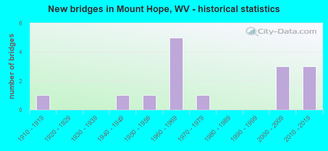
- New bridges - historical statistics
- 11910-1919
- 11940-1949
- 11950-1959
- 51960-1969
- 11970-1979
- 32000-2009
- 32010-2019

- Reconstructed bridges - Historical Statistics
- 11930-1939
- 01940-1949
- 01950-1959
- 01960-1969
- 01970-1979
- 11980-1989


- Bridge Condition - Deck
- 18.2%Very good
- 9.1%Good
- 27.3%Satisfactory
- 45.5%Fair

- Bridge Condition - Superstructure
- 27.3%Very good
- 9.1%Good
- 18.2%Satisfactory
- 45.5%Fair

- Bridge Condition - Substructure
- 18.2%Very good
- 9.1%Good
- 27.3%Satisfactory
- 45.5%Fair

- Bridge Condition - Channel
- 16.7%Excellent
- 25.0%Very good
- 41.7%Good
- 16.7%Satisfactory
Find on map >> Show street view
Structure Number: 10A085, Location: 1.88 Miles S. of CR 21/5 (Lat: 37.895761, Lng: -81.181839), Route carried "on" structure: US 1900, Year Built: 1969, Status: Open, Structure Length: 18.09m (59.35ft), Average Daily Traffic: 23,327 (year 2020), Truck Traffic: 12%, Average Future Daily Traffic: 28,459 (year 2040), Design Load: HS 20, Features Intersected: CR 27,RJCormanRR,SugarCK, Facility Carried by Structure: US 19 NBL
Minimum Vertical Clearance: 30+ m (98+ ft), Kilometerpoint: 1.561, Lanes on structure: 2, Lanes under structure: 2, Base Highway Network: Yes, Owner: State Highway Agency, Approaching Roadway Width: 12.2m (40.0ft), Skew: 5 degrees, Material/Design: Steel continuous, Design/Construction: Stringer/Multi-beam, Number Of Spans In Main Unit: 4, Length of Maximum Span: 53.6m (175.9ft), Curb-To-Curb Width: 12.2m (40.0ft), Out-to-Out Width: 13.4m (44.0ft)
Condition: Deck: Satisfactory, Superstructure: Fair, Substructure: Satisfactory, Channel: Very good, Operating Rating: 66.2 metric tons, Method Used To Determine Operating Rating: Load Factor (LF), Inventory Rating: 39.9 metric tons, Method Used To Determine Inventory Rating: Load Factor (LF), Structural Evaluation: Somewhat better than minimum adequacy, Deck Geometry: Better than present minimum criteria, Underclear: Meets minimum limits, Waterway Adequacy: Superior to present desirable criteria, Approach Roadway Alignment: Superior to present desirable criteria, Designated Inspection Frequency: Every 24 months, Inspection Date: May 2021, Deck Structure Type: Concrete Cast-file-Place, Wearing Surface/Protective System: Wearing Surface: Latex Concrete
Find on map >> Show street view
Structure Number: 10A086, Location: 1.88 Miles S. of CR 21/5 (Lat: 37.895711, Lng: -81.182131), Route carried "on" structure: US 1900, Year Built: 1969, Status: Posted for load-capacity, Structure Length: 18.09m (59.35ft), Average Daily Traffic: 23,327 (year 2020), Truck Traffic: 12%, Average Future Daily Traffic: 28,459 (year 2040), Design Load: HS 20, Features Intersected: CR 27,RJCormanRR,SugarCk, Facility Carried by Structure: US 19 SBL
Minimum Vertical Clearance: 30+ m (98+ ft), Kilometerpoint: 1.561, Lanes on structure: 2, Lanes under structure: 2, Base Highway Network: Yes, Owner: State Highway Agency, Approaching Roadway Width: 12.2m (40.0ft), Skew: 5 degrees, Material/Design: Steel continuous, Design/Construction: Stringer/Multi-beam, Number Of Spans In Main Unit: 2, Number Of Approach Spans: 2, Length of Maximum Span: 53.6m (175.9ft), Curb-To-Curb Width: 12.2m (40.0ft), Out-to-Out Width: 13.4m (44.0ft)
Condition: Deck: Satisfactory, Superstructure: Satisfactory, Substructure: Fair, Channel: Good, Operating Rating: 37.2 metric tons, Method Used To Determine Operating Rating: Load Factor (LF), Inventory Rating: 22.7 metric tons, Method Used To Determine Inventory Rating: Load Factor (LF), Structural Evaluation: Somewhat better than minimum adequacy, Deck Geometry: Better than present minimum criteria, Underclear: Equal to present minimum criteria, Waterway Adequacy: Superior to present desirable criteria, Approach Roadway Alignment: Equal to present desirable criteria, Designated Inspection Frequency: Every 24 months, Inspection Date: May 2021, Deck Structure Type: Concrete Cast-file-Place, Wearing Surface/Protective System: Wearing Surface: Latex Concrete
Find on map >> Show street view
Structure Number: 10A087, Location: 0.07 Miles N. of WV 211 (Lat: 37.889411, Lng: -81.174881), Route carried "on" structure: State highway 1600, Year Built: 1955, Status: Posted for load, Structure Length: 1.17m (3.84ft), Average Daily Traffic: 2,226 (year 2016), Truck Traffic: 6%, Average Future Daily Traffic: 2,716 (year 2036), Features Intersected: DUNLOUP CREEK, Facility Carried by Structure: WV 16
Minimum Vertical Clearance: 30+ m (98+ ft), Kilometerpoint: 1.609, Lanes on structure: 2, Owner: State Highway Agency, Approaching Roadway Width: 7.9m (25.9ft), Skew: 4 degrees, Material/Design: Concrete continuous, Design/Construction: Culvert, Number Of Spans In Main Unit: 3, Length of Maximum Span: 3.4m (11.2ft)
Condition: Channel: Satisfactory, Culverts: Satisfactory, Operating Rating: 53.5 metric tons, Method Used To Determine Operating Rating: Field evaluation and documented engineering judgment, Inventory Rating: 24.5 metric tons, Method Used To Determine Inventory Rating: Field evaluation and documented engineering judgment, Structural Evaluation: Equal to present minimum criteria, Waterway Adequacy: Superior to present desirable criteria, Approach Roadway Alignment: Better than present minimum criteria, Designated Inspection Frequency: Every 24 months, Inspection Date: October 2021
Find on map >> Show street view
Structure Number: 10A099, Location: 0.14 Miles E. of WV 16 (Lat: 37.905789, Lng: -81.154919), Route carried "on" structure: County highway 2106, Year Built: 1949, Year Reconstructed: 1988, Status: Open, Structure Length: 1.22m (4.00ft), Average Daily Traffic: 18 (year 2019), Truck Traffic: 6%, Average Future Daily Traffic: 22 (year 2039), Features Intersected: DUNLOUP CREEK, Facility Carried by Structure: COUNTY ROUTE 21/6
Minimum Vertical Clearance: 30+ m (98+ ft), Kilometerpoint: 0.225, Lanes on structure: 1, Owner: State Highway Agency, Approaching Roadway Width: 3.0m (9.8ft), Skew: 1 degrees, Material/Design: Steel, Design/Construction: Girder and Floorbeam System, Number Of Spans In Main Unit: 1, Length of Maximum Span: 11.6m (38.1ft), Curb-To-Curb Width: 4.7m (15.4ft), Out-to-Out Width: 4.9m (16.1ft)
Condition: Deck: Fair, Superstructure: Fair, Substructure: Fair, Channel: Good, Operating Rating: 58.0 metric tons, Method Used To Determine Operating Rating: Load Factor (LF), Inventory Rating: 35.4 metric tons, Method Used To Determine Inventory Rating: Load Factor (LF), Structural Evaluation: Somewhat better than minimum adequacy, Deck Geometry: Better than present minimum criteria, Waterway Adequacy: Better than present minimum criteria, Approach Roadway Alignment: Somewhat better than minimum adequacy, Designated Inspection Frequency: Every 24 months, Critical Feature Inspection Frequency: Every 24 months, Inspection Date: December 2019, Critical Feature Inspection Date: December 2019, Deck Structure Type: Wood or Timber, Wearing Surface/Protective System: Deck Protection: Other
Find on map >> Show street view
Structure Number: 10A177, Location: 0.01 Miles E. of CR 61/57 (Lat: 37.882869, Lng: -81.156431), Route carried "on" structure: County highway 6158, Year Built: 1972, Status: Posted for load, Structure Length: 1.88m (6.17ft), Average Daily Traffic: 40 (year 2020), Truck Traffic: 6%, Average Future Daily Traffic: 49 (year 2040), Features Intersected: MILL CREEK, Facility Carried by Structure: COUNTY ROUTE 61/58
Minimum Vertical Clearance: 30+ m (98+ ft), Kilometerpoint: 0.016, Lanes on structure: 1, Owner: State Highway Agency, Approaching Roadway Width: 4.0m (13.1ft), Material/Design: Steel, Design/Construction: Girder and Floorbeam System, Number Of Spans In Main Unit: 1, Length of Maximum Span: 17.7m (58.1ft), Curb-To-Curb Width: 4.8m (15.7ft), Out-to-Out Width: 4.8m (15.7ft)
Condition: Deck: Fair, Superstructure: Fair, Substructure: Fair, Channel: Good, Operating Rating: 37.2 metric tons, Method Used To Determine Operating Rating: Load Factor (LF), Inventory Rating: 22.7 metric tons, Method Used To Determine Inventory Rating: Load Factor (LF), Structural Evaluation: Somewhat better than minimum adequacy, Deck Geometry: Equal to present desirable criteria, Waterway Adequacy: Superior to present desirable criteria, Approach Roadway Alignment: Meets minimum limits, Length Of Structure Improvement: 2.59m (8.50ft), Designated Inspection Frequency: Every 24 months, Critical Feature Inspection Frequency: Every 24 months, Inspection Date: October 2021, Critical Feature Inspection Date: October 2021, Bridge Improvement Cost: $138,000, Roadway Improvement Cost: $136,000, Total Project Cost: $321,000 ( Estimate for 2022), Deck Structure Type: Wood or Timber, Wearing Surface/Protective System: Deck Protection: Other
Find on map >> Show street view
Structure Number: 10A301, Location: 0.13 Miles S. of WV 211 (Lat: 37.899011, Lng: -81.154831), Route carried "on" structure: State highway 1600, Year Built: 2009, Status: Open, Structure Length: 9.89m (32.45ft), Average Daily Traffic: 2,053 (year 2019), Truck Traffic: 6%, Average Future Daily Traffic: 2,505 (year 2039), Design Load: HL 93, Features Intersected: CR 61/23 Dunloup Cr & RR, Facility Carried by Structure: WV 16
Minimum Vertical Clearance: 30+ m (98+ ft), Kilometerpoint: 3.830, Lanes on structure: 2, Lanes under structure: 2, Base Highway Network: Yes, Owner: State Highway Agency, Approaching Roadway Width: 10.7m (35.1ft), Skew: 4 degrees, Material/Design: Steel continuous, Design/Construction: Stringer/Multi-beam, Number Of Spans In Main Unit: 4, Length of Maximum Span: 24.4m (80.1ft), Curb-To-Curb Width: 10.4m (34.1ft), Out-to-Out Width: 11.2m (36.7ft)
Condition: Deck: Good, Superstructure: Very good, Substructure: Satisfactory, Channel: Excellent, Operating Rating: 41.7 metric tons, Method Used To Determine Operating Rating: Load and Resistance Factor (LRFR), Inventory Rating: 32.7 metric tons, Method Used To Determine Inventory Rating: Load and Resistance Factor (LRFR), Structural Evaluation: Equal to present minimum criteria, Deck Geometry: Somewhat better than minimum adequacy, Underclear: Meets minimum limits, Waterway Adequacy: Superior to present desirable criteria, Approach Roadway Alignment: Equal to present desirable criteria, Designated Inspection Frequency: Every 24 months, Inspection Date: August 2020, Deck Structure Type: Concrete Cast-file-Place, Wearing Surface/Protective System: Wearing Surface: Monolithic Concrete, Deck Protection: Epoxy Coated Reinforcing
Find on map >> Show street view
Structure Number: 10A303, Location: 0.03 Miles N. of CR 19/21 (Lat: 37.890450, Lng: -81.164650), Route carried "on" structure: State highway 1600, Year Built: 2011, Status: Open, Structure Length: 10.00m (32.81ft), Average Daily Traffic: 2,300 (year 2019), Truck Traffic: 11%, Average Future Daily Traffic: 2,806 (year 2039), Features Intersected: MILL CREEK & CSX RR, Facility Carried by Structure: WV 16
Minimum Vertical Clearance: 30+ m (98+ ft), Kilometerpoint: 2.527, Lanes on structure: 2, Owner: State Highway Agency, Approaching Roadway Width: 10.4m (34.1ft), Material/Design: Steel continuous, Design/Construction: Stringer/Multi-beam, Number Of Spans In Main Unit: 3, Length of Maximum Span: 39.6m (129.9ft), Curb-To-Curb Width: 10.3m (33.8ft), Out-to-Out Width: 11.2m (36.7ft)
Condition: Deck: Satisfactory, Superstructure: Good, Substructure: Good, Channel: Excellent, Operating Rating: 42.6 metric tons, Method Used To Determine Operating Rating: Load and Resistance Factor (LRFR), Inventory Rating: 33.6 metric tons, Method Used To Determine Inventory Rating: Load and Resistance Factor (LRFR), Structural Evaluation: Better than present minimum criteria, Deck Geometry: Meets minimum limits, Underclear: Equal to present desirable criteria, Waterway Adequacy: Superior to present desirable criteria, Approach Roadway Alignment: Better than present minimum criteria, Designated Inspection Frequency: Every 24 months, Inspection Date: June 2021, Deck Structure Type: Concrete Cast-file-Place, Wearing Surface/Protective System: Wearing Surface: Latex Concrete
Find on map >> Show street view
Structure Number: 10A313, Location: 0.12 Miles S. of CR 20/1 (Lat: 37.941219, Lng: -81.161081), Route carried "on" structure: County highway 2120, Year Built: 2014, Status: Open, Structure Length: 1.21m (3.97ft), Average Daily Traffic: 1,542 (year 2019), Truck Traffic: 6%, Average Future Daily Traffic: 1,922 (year 2039), Design Load: HL 93, Features Intersected: White Oak Creek, Facility Carried by Structure: COUNTY ROUTE 21/20
Minimum Vertical Clearance: 30+ m (98+ ft), Kilometerpoint: 1.577, Lanes on structure: 2, Owner: State Highway Agency, Approaching Roadway Width: 7.3m (24.0ft), Skew: 2 degrees, Material/Design: Prestressed concrete, Design/Construction: Box Beam or Girders - Multiple, Number Of Spans In Main Unit: 1, Length of Maximum Span: 11.0m (36.1ft), Curb-To-Curb Width: 7.3m (24.0ft), Out-to-Out Width: 7.3m (24.0ft)
Condition: Deck: Very good, Superstructure: Very good, Substructure: Very good, Channel: Very good, Operating Rating: 49.9 metric tons, Method Used To Determine Operating Rating: Load and Resistance Factor (LRFR), Inventory Rating: 38.1 metric tons, Method Used To Determine Inventory Rating: Load and Resistance Factor (LRFR), Structural Evaluation: Equal to present desirable criteria, Deck Geometry: Meets minimum limits, Waterway Adequacy: Equal to present desirable criteria, Approach Roadway Alignment: Superior to present desirable criteria, Designated Inspection Frequency: Every 48 months, Inspection Date: May 2020, Deck Structure Type: Other, Wearing Surface/Protective System: Wearing Surface: Bituminous
Find on map >> Show street view
Structure Number: 10A318, Location: 0.04 mi. East of WV 211 (Lat: 37.896811, Lng: -81.160431), Route carried "on" structure: State highway 6100, Year Built: 2018, Status: Open, Structure Length: 3.15m (10.33ft), Average Daily Traffic: 542 (year 2019), Truck Traffic: 5%, Average Future Daily Traffic: 661 (year 2039), Design Load: HL 93, Features Intersected: Dunloup Creek, Facility Carried by Structure: WV 61 Alternate
Minimum Vertical Clearance: 30+ m (98+ ft), Kilometerpoint: 0.064, Lanes on structure: 2, Owner: State Highway Agency, Approaching Roadway Width: 10.7m (35.1ft), Skew: 15 degrees, Material/Design: Steel continuous, Design/Construction: Stringer/Multi-beam, Number Of Spans In Main Unit: 1, Length of Maximum Span: 22.6m (74.1ft), Curb or Sidewalk Widths: Left: 0.0m, Right: 1.5m (4.9ft), Curb-To-Curb Width: 10.1m (33.1ft), Out-to-Out Width: 12.2m (40.0ft)
Condition: Deck: Very good, Superstructure: Very good, Substructure: Very good, Channel: Satisfactory, Operating Rating: 88.9 metric tons, Method Used To Determine Operating Rating: Load and Resistance Factor (LRFR), Inventory Rating: 80.7 metric tons, Method Used To Determine Inventory Rating: Load and Resistance Factor (LRFR), Structural Evaluation: Equal to present desirable criteria, Deck Geometry: Equal to present minimum criteria, Waterway Adequacy: Better than present minimum criteria, Approach Roadway Alignment: Equal to present desirable criteria, Designated Inspection Frequency: Every 24 months, Inspection Date: October 2020, Deck Structure Type: Concrete Cast-file-Place, Wearing Surface/Protective System: Wearing Surface: Integral Concrete, Deck Protection: Epoxy Coated Reinforcing
Find on map >> Show street view
Structure Number: 10A903, Location: 0.01 Miles S. of WV 211 (Lat: 37.889919, Lng: -81.173619), Route carried "on" structure: City street N1110, Year Built: 1910, Year Reconstructed: 1930, Status: Posted for load, Structure Length: 0.71m (2.33ft), Average Daily Traffic: 50 (year 2019), Average Future Daily Traffic: 63 (year 2039), Features Intersected: DUNLOUP CREEK, Facility Carried by Structure: FREEWILL LANE
Minimum Vertical Clearance: 30+ m (98+ ft), Kilometerpoint: 0.016, Lanes on structure: 2, Owner: City or Municipal Highway Agency, Approaching Roadway Width: 4.0m (13.1ft), Material/Design: Masonry, Design/Construction: Arch - Deck, Number Of Spans In Main Unit: 1, Length of Maximum Span: 7.1m (23.3ft), Curb or Sidewalk Widths: Left: 0.4m (1.3ft), Right: 0.4m (1.3ft), Curb-To-Curb Width: 5.9m (19.4ft), Out-to-Out Width: 6.7m (22.0ft)
Condition: Deck: Fair, Superstructure: Fair, Substructure: Fair, Channel: Good, Operating Rating: 31.7 metric tons, Method Used To Determine Operating Rating: Field evaluation and documented engineering judgment, Inventory Rating: 14.5 metric tons, Method Used To Determine Inventory Rating: Field evaluation and documented engineering judgment, Structural Evaluation: Meets minimum limits, Deck Geometry: Meets minimum limits, Waterway Adequacy: Equal to present desirable criteria, Approach Roadway Alignment: Equal to present minimum criteria, Designated Inspection Frequency: Every 24 months, Inspection Date: August 2021, Deck Structure Type: Concrete Cast-file-Place, Wearing Surface/Protective System: Wearing Surface: Bituminous
Find on map >> Show street view
Structure Number: 10A904, Location: 0.06 Miles N. of WV 211 (Lat: 37.894569, Lng: -81.166361), Route carried "on" structure: City street N1110, Year Built: 1960, Status: Posted for load, Structure Length: 1.11m (3.64ft), Average Daily Traffic: 100 (year 2019), Average Future Daily Traffic: 122 (year 2039), Features Intersected: SUGAR CREEK, Facility Carried by Structure: STADIUM DRIVE
Minimum Vertical Clearance: 30+ m (98+ ft), Kilometerpoint: 0.032, Lanes on structure: 2, Owner: City or Municipal Highway Agency, Approaching Roadway Width: 6.1m (20.0ft), Skew: 4 degrees, Material/Design: Steel, Design/Construction: Stringer/Multi-beam, Number Of Spans In Main Unit: 1, Length of Maximum Span: 8.2m (26.9ft), Curb or Sidewalk Widths: Left: 1.1m (3.6ft), Right: 0.0m, Curb-To-Curb Width: 6.7m (22.0ft), Out-to-Out Width: 8.0m (26.2ft)
Condition: Deck: Fair, Superstructure: Fair, Substructure: Fair, Channel: Good, Operating Rating: 11.8 metric tons, Method Used To Determine Operating Rating: Load Factor (LF), Inventory Rating: 7.3 metric tons, Method Used To Determine Inventory Rating: Load Factor (LF), Structural Evaluation: High priority of corrective action, Deck Geometry: Somewhat better than minimum adequacy, Waterway Adequacy: Better than present minimum criteria, Approach Roadway Alignment: Somewhat better than minimum adequacy, Bridge Posting: Required (Relationship of Operating Rating to Maximum Legal Load: > 39.9% below), Designated Inspection Frequency: Every 24 months, Inspection Date: January 2020, Deck Structure Type: Concrete Cast-file-Place, Wearing Surface/Protective System: Wearing Surface: Bituminous
Find on map >> Show street view
Structure Number: 41A27, Location: 0.21 Miles S. of CR 61/58 (Lat: 37.882869, Lng: -81.156431), Route carried "on" structure: County highway 6193, Year Built: 2000, Status: Open, Structure Length: 0.85m (2.79ft), Average Daily Traffic: 20 (year 2020), Truck Traffic: 6%, Average Future Daily Traffic: 24 (year 2040), Design Load: HS 25 or greater, Features Intersected: MILL CREEK, Facility Carried by Structure: COUNTY ROUTE 61/93
Minimum Vertical Clearance: 30+ m (98+ ft), Kilometerpoint: 0.322, Lanes on structure: 1, Owner: State Highway Agency, Approaching Roadway Width: 3.0m (9.8ft), Skew: 3 degrees, Material/Design: Steel, Design/Construction: Stringer/Multi-beam, Number Of Spans In Main Unit: 1, Length of Maximum Span: 7.7m (25.3ft), Curb-To-Curb Width: 3.5m (11.5ft), Out-to-Out Width: 3.6m (11.8ft)
Condition: Deck: Fair, Superstructure: Satisfactory, Substructure: Satisfactory, Channel: Very good, Operating Rating: 88.9 metric tons, Method Used To Determine Operating Rating: Load Factor (LF), Inventory Rating: 59.9 metric tons, Method Used To Determine Inventory Rating: Load Factor (LF), Structural Evaluation: Equal to present minimum criteria, Deck Geometry: High priority of corrective action, Waterway Adequacy: Equal to present desirable criteria, Approach Roadway Alignment: Equal to present minimum criteria, Designated Inspection Frequency: Every 24 months, Inspection Date: October 2021, Deck Structure Type: Wood or Timber, Wearing Surface/Protective System: Deck Protection: Other
Find on map >> Show street view
Structure Number: 10A085, Location: 1.88 Miles S. of CR 21/5 (Lat: 37.895542, Lng: -81.182031), Route carried "under" structure: County highway 2700, Year Built: 1969, Structure Length: 0. m, Average Daily Traffic: 1,000 (year 0012), Truck Traffic: 6%, Features Intersected: CR 27,RJCormanRR,SugarCK, Facility Carried by Structure: US 19 NBL
Minimum Vertical Clearance: 10.67m (35.01ft), Kilometerpoint: 9.012, Lanes on structure: 2, Lanes under structure: 2, Length of Maximum Span: 53.6m (175.9ft)
Find on map >> Show street view
Structure Number: 10A086, Location: 1.88 Miles S. of CR 21/5 (Lat: 37.895436, Lng: -81.182422), Route carried "under" structure: County highway 2700, Year Built: 1969, Structure Length: 0. m, Average Daily Traffic: 1,000 (year 0012), Truck Traffic: 6%, Features Intersected: CR 27,RJCormanRR,SugarCk, Facility Carried by Structure: US 19 SBL
Minimum Vertical Clearance: 11.56m (37.93ft), Kilometerpoint: 9.012, Lanes on structure: 2, Lanes under structure: 2, Length of Maximum Span: 53.6m (175.9ft)
Find on map >> Show street view
Structure Number: 10A301, Location: 0.13 Miles S. of WV 211 (Lat: 37.898783, Lng: -81.155067), Route carried "under" structure: County highway 6123, Year Built: 2009, Structure Length: 0. m, Average Daily Traffic: 100 (year 0012), Features Intersected: CR 61/23 Dunloup Cr & RR, Facility Carried by Structure: WV 16
Minimum Vertical Clearance: 4.42m (14.50ft), Kilometerpoint: 0.402, Lanes on structure: 2, Lanes under structure: 2, Length of Maximum Span: 24.4m (80.1ft)