Bridge Statistics for Mount Clemens, Michigan (MI)
Condition, Traffic, Stress, Structural Evaluation, Project Costs
- National Bridge Inventory (NBI) Statistics
- 17Number of bridges
- 233ft / 70.6mTotal length
- $5,583,000Total costs
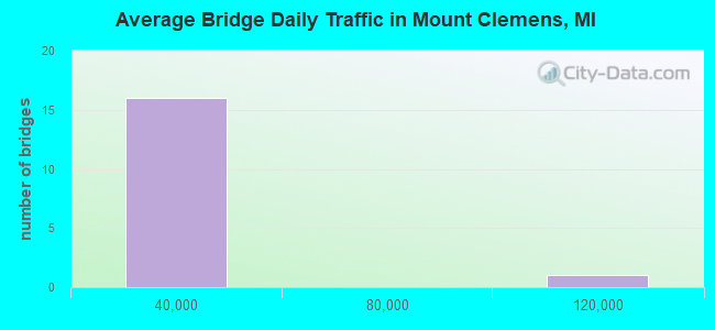
- 320,904Total average daily traffic
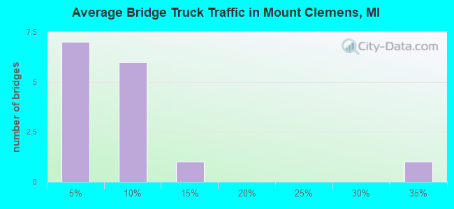
- 16,866Total average daily truck traffic
- National Bridge Inventory (NBI) Registered Bridges for Mount Clemens
- No street view available for this location
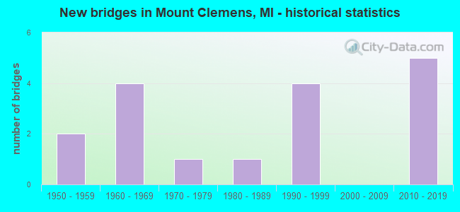
- New bridges - historical statistics
- 21950-1959
- 41960-1969
- 11970-1979
- 11980-1989
- 41990-1999
- 52010-2019
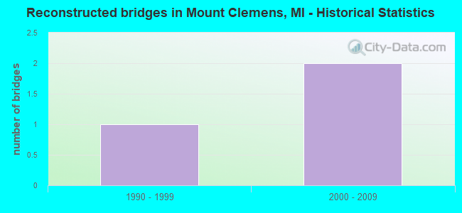
- Reconstructed bridges - Historical Statistics
- 11990-1999
- 22000-2009
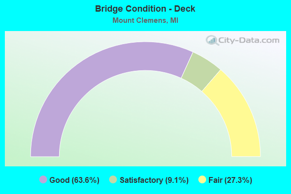
- Bridge Condition - Deck
- 63.6%Good
- 9.1%Satisfactory
- 27.3%Fair
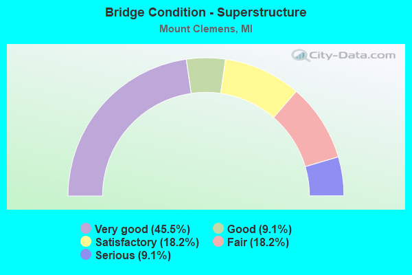
- Bridge Condition - Superstructure
- 45.5%Very good
- 9.1%Good
- 18.2%Satisfactory
- 18.2%Fair
- 9.1%Serious
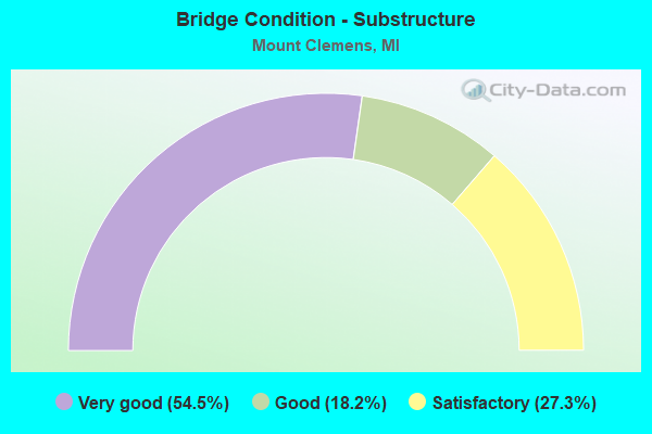
- Bridge Condition - Substructure
- 54.5%Very good
- 18.2%Good
- 27.3%Satisfactory
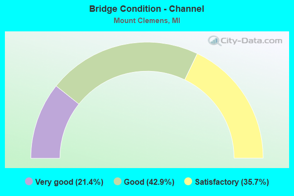
- Bridge Condition - Channel
- 21.4%Very good
- 42.9%Good
- 35.7%Satisfactory
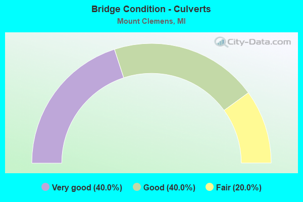
- Bridge Condition - Culverts
- 40.0%Very good
- 40.0%Good
- 20.0%Fair
Find on map >> Show street view
Structure Number: 607, Location: 1.5 MI S OF KAWKAWLIN (Lat: 43.639833, Lng: -83.974847), Route carried "on" structure: Interstate 75, Year Built: 1968, Status: Open, Structure Length: 5.76m (18.90ft), Average Daily Traffic: 11,225 (year 2019), Truck Traffic: 9%, Average Future Daily Traffic: 12,909 (year 2039), Design Load: HS 20+Mod, Features Intersected: KAWKAWLIN RIVER
Minimum Vertical Clearance: 30.48m (100.00ft), Kilometerpoint: 13.950, Lanes on structure: 2, Base Highway Network: Yes (Inventory Route: 76, Subroute: 10), Owner: State Highway Agency, Approaching Roadway Width: 12.2m (40.0ft), Material/Design: Prestressed concrete, Design/Construction: Stringer/Multi-beam, Number Of Spans In Main Unit: 3, Length of Maximum Span: 19.2m (63.0ft), Curb-To-Curb Width: 11.8m (38.7ft), Out-to-Out Width: 12.8m (42.0ft)
Condition: Deck: Good, Superstructure: Fair, Substructure: Good, Channel: Very good, Operating Rating: 73.5 metric tons, Method Used To Determine Operating Rating: Load Factor (LF) rating reported by rating factor (RF) method using MS18 loading, Inventory Rating: 38.2 metric tons, Method Used To Determine Inventory Rating: Load Factor (LF) rating reported by rating factor (RF) method using MS18 loading, Structural Evaluation: Somewhat better than minimum adequacy, Deck Geometry: Equal to present minimum criteria, Waterway Adequacy: Better than present minimum criteria, Approach Roadway Alignment: Equal to present desirable criteria, Designated Inspection Frequency: Every 24 months, Inspection Date: October 2021, Deck Structure Type: Concrete Cast-file-Place, Wearing Surface/Protective System: Wearing Surface: Latex Concrete, Deck Protection: Epoxy Coated Reinforcing
Find on map >> Show street view
Structure Number: 3287, Location: 0.5 MILE WEST OF TRIPP RD (Lat: 41.753083, Lng: -84.524072), Route carried "on" structure: County highway 3018, Year Built: 2011, Status: Open, Structure Length: 0.88m (2.89ft), Average Daily Traffic: 720 (year 2013), Truck Traffic: 34%, Average Future Daily Traffic: 1,181 (year 2038), Design Load: HL 93, Features Intersected: LAIRD CREEK, Facility Carried by Structure: CAMDEN ROAD
Minimum Vertical Clearance: 30.48m (100.00ft), Kilometerpoint: 23.481, Lanes on structure: 2, Owner: County Highway Agency, Approaching Roadway Width: 10.4m (34.1ft), Skew: 1 degrees, Material/Design: Concrete, Design/Construction: Culvert, Number Of Spans In Main Unit: 1, Length of Maximum Span: 8.5m (27.9ft), Curb-To-Curb Width: 10.4m (34.1ft), Out-to-Out Width: 11.2m (36.7ft)
Condition: Channel: Good, Culverts: Good, Operating Rating: 81.3 metric tons, Method Used To Determine Operating Rating: Load and Resistance Factor (LRFR), Inventory Rating: 48.7 metric tons, Method Used To Determine Inventory Rating: Load and Resistance Factor (LRFR), Structural Evaluation: Better than present minimum criteria, Deck Geometry: Equal to present minimum criteria, Waterway Adequacy: Equal to present desirable criteria, Approach Roadway Alignment: Equal to present desirable criteria, Designated Inspection Frequency: Every 24 months, Inspection Date: November 2020, Wearing Surface/Protective System: Wearing Surface: Bituminous
Find on map >> Show street view
Structure Number: 6048, Location: 4.2 MI E OF M-53 (Lat: 42.628697, Lng: -82.931108), Route carried "on" structure: State highway 59, Year Built: 1996, Status: Open, Structure Length: 4.11m (13.48ft), Average Daily Traffic: 31,800 (year 2021), Truck Traffic: 3%, Average Future Daily Traffic: 35,150 (year 2041), Design Load: HS 25 or greater, Features Intersected: MIDDLE BR CLINTON RIVER
Minimum Vertical Clearance: 30.48m (100.00ft), Kilometerpoint: 8.388, Lanes on structure: 3, Base Highway Network: Yes (Inventory Route: 82, Subroute: 2), Owner: State Highway Agency, Approaching Roadway Width: 14.6m (47.9ft), Material/Design: Prestressed concrete, Design/Construction: Stringer/Multi-beam, Number Of Spans In Main Unit: 3, Length of Maximum Span: 13.7m (44.9ft), Curb or Sidewalk Widths: Left: 0.0m, Right: 1.4m (4.6ft), Curb-To-Curb Width: 16.5m (54.1ft), Out-to-Out Width: 19.1m (62.7ft)
Condition: Deck: Good, Superstructure: Very good, Substructure: Very good, Channel: Good, Operating Rating: 56.1 metric tons, Method Used To Determine Operating Rating: Load Factor (LF) rating reported by rating factor (RF) method using MS18 loading, Inventory Rating: 33.7 metric tons, Method Used To Determine Inventory Rating: Load Factor (LF) rating reported by rating factor (RF) method using MS18 loading, Structural Evaluation: Equal to present desirable criteria, Deck Geometry: Better than present minimum criteria, Waterway Adequacy: Meets minimum limits, Approach Roadway Alignment: Equal to present minimum criteria, Designated Inspection Frequency: Every 24 months, Inspection Date: December 2021, Deck Structure Type: Concrete Cast-file-Place, Wearing Surface/Protective System: Wearing Surface: Epoxy Overlay, Deck Protection: Epoxy Coated Reinforcing
Find on map >> Show street view
Structure Number: 6069, Location: IN MT CLEMENS (Lat: 42.585219, Lng: -82.883503), Route carried "on" structure: State highway 3, Year Built: 2011, Status: Open, Structure Length: 7.62m (25.00ft), Average Daily Traffic: 22,300 (year 2008), Truck Traffic: 2%, Average Future Daily Traffic: 26,250 (year 2031), Design Load: HL 93, Features Intersected: CLINTON RIVER
Minimum Vertical Clearance: 30.48m (100.00ft), Kilometerpoint: 16.530, Lanes on structure: 4, Base Highway Network: Yes (Inventory Route: 420, Subroute: 3), Owner: State Highway Agency, Approaching Roadway Width: 14.6m (47.9ft), Skew: 2 degrees, Material/Design: Prestressed concrete, Design/Construction: Box Beam or Girders - Single/Spread, Number Of Spans In Main Unit: 3, Length of Maximum Span: 26.9m (88.3ft), Curb or Sidewalk Widths: Left: 1.5m (4.9ft), Right: 4.3m (14.1ft), Curb-To-Curb Width: 15.9m (52.2ft), Out-to-Out Width: 22.4m (73.5ft)
Condition: Deck: Good, Superstructure: Very good, Substructure: Very good, Channel: Satisfactory, Operating Rating: 64.5 metric tons, Method Used To Determine Operating Rating: Load and Resistance Factor Rating (LRFR) rating reported by rating factor(RF) method using HL-93 loadings, Inventory Rating: 37.3 metric tons, Method Used To Determine Inventory Rating: Load and Resistance Factor Rating (LRFR) rating reported by rating factor(RF) method using HL-93 loadings, Structural Evaluation: Equal to present desirable criteria, Deck Geometry: Meets minimum limits, Waterway Adequacy: Equal to present desirable criteria, Approach Roadway Alignment: Superior to present desirable criteria, Designated Inspection Frequency: Every 24 months, Underwater Inspection Frequency: Every 60 months, Inspection Date: December 2021, Underwater Inspection Date: April 2020, Deck Structure Type: Concrete Cast-file-Place, Wearing Surface/Protective System: Wearing Surface: Monolithic Concrete, Deck Protection: Epoxy Coated Reinforcing
Find on map >> Show street view
Structure Number: 607, Location: IN MT CLEMENS (Lat: 42.584433, Lng: -82.882475), Route carried "on" structure: State highway 3, Year Built: 2011, Status: Open, Structure Length: 8.23m (27.00ft), Average Daily Traffic: 18,500 (year 2008), Truck Traffic: 2%, Average Future Daily Traffic: 21,750 (year 2031), Design Load: HL 93, Features Intersected: CLINTON RIVER
Minimum Vertical Clearance: 30.48m (100.00ft), Kilometerpoint: 1.107, Lanes on structure: 3, Base Highway Network: Yes (Inventory Route: 83, Subroute: 9), Owner: State Highway Agency, Approaching Roadway Width: 14.6m (47.9ft), Skew: 3 degrees, Material/Design: Prestressed concrete, Design/Construction: Box Beam or Girders - Single/Spread, Number Of Spans In Main Unit: 3, Length of Maximum Span: 29.9m (98.1ft), Curb or Sidewalk Widths: Left: 1.8m (5.9ft), Right: 1.8m (5.9ft), Curb-To-Curb Width: 12.8m (42.0ft), Out-to-Out Width: 17.2m (56.4ft)
Condition: Deck: Good, Superstructure: Very good, Substructure: Good, Channel: Very good, Operating Rating: 98.5 metric tons, Method Used To Determine Operating Rating: Load Factor (LF), Inventory Rating: 37.5 metric tons, Method Used To Determine Inventory Rating: Load Factor (LF), Structural Evaluation: Better than present minimum criteria, Deck Geometry: Meets minimum limits, Waterway Adequacy: Equal to present minimum criteria, Approach Roadway Alignment: Better than present minimum criteria, Designated Inspection Frequency: Every 24 months, Underwater Inspection Frequency: Every 60 months, Inspection Date: December 2021, Underwater Inspection Date: April 2020, Deck Structure Type: Concrete Cast-file-Place, Wearing Surface/Protective System: Wearing Surface: Monolithic Concrete, Deck Protection: Epoxy Coated Reinforcing
Find on map >> Show street view
Structure Number: 6175, Location: 1.1 MI NE OF M-59 (Lat: 42.645386, Lng: -82.840314), Route carried "on" structure: County highway 2058, Year Built: 1960, Year Reconstructed: 2006, Status: Open, Structure Length: 7.45m (24.44ft), Average Daily Traffic: 16,870 (year 1993), Truck Traffic: 3%, Average Future Daily Traffic: 19,401 (year 2013), Design Load: HS 20+Mod, Features Intersected: I-94, Facility Carried by Structure: 21 MI RD
Minimum Vertical Clearance: 30.48m (100.00ft), Kilometerpoint: 16.289, Lanes on structure: 4, Lanes under structure: 4, Owner: State Highway Agency, Approaching Roadway Width: 24.0m (78.7ft), Skew: 22 degrees, Material/Design: Steel, Design/Construction: Stringer/Multi-beam, Number Of Spans In Main Unit: 4, Length of Maximum Span: 27.4m (89.9ft), Curb-To-Curb Width: 21.8m (71.5ft), Out-to-Out Width: 23.4m (76.8ft)
Condition: Deck: Fair, Superstructure: Good, Substructure: Satisfactory, Operating Rating: 67.1 metric tons, Method Used To Determine Operating Rating: Load Factor (LF) rating reported by rating factor (RF) method using MS18 loading, Inventory Rating: 40.2 metric tons, Method Used To Determine Inventory Rating: Load Factor (LF) rating reported by rating factor (RF) method using MS18 loading, Structural Evaluation: Equal to present minimum criteria, Deck Geometry: Superior to present desirable criteria, Underclear: High priority of corrective action, Approach Roadway Alignment: Better than present minimum criteria, Designated Inspection Frequency: Every 24 months, Inspection Date: June 2021, Deck Structure Type: Concrete Cast-file-Place, Wearing Surface/Protective System: Wearing Surface: Latex Concrete
Find on map >> Show street view
Structure Number: 6209, Location: 0.2 MI WEST OF NORTH AVE (Lat: 42.673411, Lng: -82.881994), Route carried "on" structure: County highway 2058, Year Built: 2013, Status: Open, Structure Length: 6.28m (20.60ft), Average Daily Traffic: 18,430 (year 2012), Truck Traffic: 5%, Average Future Daily Traffic: 29,644 (year 2032), Design Load: Greater than HL93, Features Intersected: N BRANCH CLINTON RIVER, Facility Carried by Structure: 23 MILE ROAD
Minimum Vertical Clearance: 30.48m (100.00ft), Kilometerpoint: 17.660, Lanes on structure: 5, Base Highway Network: Yes (Inventory Route: 80, Subroute: 6), Owner: County Highway Agency, Approaching Roadway Width: 18.3m (60.0ft), Skew: 1 degrees, Material/Design: Prestressed concrete, Design/Construction: Stringer/Multi-beam, Number Of Spans In Main Unit: 3, Length of Maximum Span: 25.5m (83.7ft), Curb-To-Curb Width: 23.2m (76.1ft), Out-to-Out Width: 24.0m (78.7ft)
Condition: Deck: Good, Superstructure: Very good, Substructure: Very good, Channel: Good, Operating Rating: 75.2 metric tons, Method Used To Determine Operating Rating: Load and Resistance Factor Rating (LRFR) rating reported by rating factor(RF) method using HL-93 loadings, Inventory Rating: 58.3 metric tons, Method Used To Determine Inventory Rating: Load and Resistance Factor Rating (LRFR) rating reported by rating factor(RF) method using HL-93 loadings, Structural Evaluation: Equal to present desirable criteria, Deck Geometry: Better than present minimum criteria, Waterway Adequacy: Superior to present desirable criteria, Approach Roadway Alignment: Equal to present desirable criteria, Designated Inspection Frequency: Every 24 months, Underwater Inspection Frequency: Every 60 months, Inspection Date: August 2021, Underwater Inspection Date: August 2018, Deck Structure Type: Concrete Cast-file-Place, Wearing Surface/Protective System: Wearing Surface: Monolithic Concrete, Deck Protection: Epoxy Coated Reinforcing
Find on map >> Show street view
Structure Number: 621, Location: 0.25 MILES WEST OF CARD (Lat: 42.673042, Lng: -82.901142), Route carried "on" structure: County highway 5050, Year Built: 1950, Status: Open, Structure Length: 0.91m (2.99ft), Average Daily Traffic: 15,350 (year 2008), Truck Traffic: 10%, Average Future Daily Traffic: 20,676 (year 2028), Design Load: H 20, Features Intersected: MCBRIDE DRAIN, Facility Carried by Structure: 23 MILE ROAD
Minimum Vertical Clearance: 30.48m (100.00ft), Kilometerpoint: 16.091, Lanes on structure: 2, Base Highway Network: Yes (Inventory Route: 80, Subroute: 6), Owner: County Highway Agency, Approaching Roadway Width: 10.0m (32.8ft), Skew: 3 degrees, Material/Design: Steel, Design/Construction: Culvert, Number Of Spans In Main Unit: 2, Length of Maximum Span: 4.5m (14.8ft)
Condition: Channel: Satisfactory, Culverts: Fair, Operating Rating: 97.2 metric tons, Method Used To Determine Operating Rating: Load Factor (LF) rating reported by rating factor (RF) method using MS18 loading, Inventory Rating: 97.2 metric tons, Method Used To Determine Inventory Rating: Load Factor (LF) rating reported by rating factor (RF) method using MS18 loading, Structural Evaluation: Somewhat better than minimum adequacy, Waterway Adequacy: Better than present minimum criteria, Approach Roadway Alignment: Equal to present desirable criteria, Designated Inspection Frequency: Every 24 months, Inspection Date: August 2020
Find on map >> Show street view
Structure Number: 6274, Location: 0.2MI WEST OF COTTON ROAD (Lat: 42.645561, Lng: -82.813222), Route carried "on" structure: County highway 2058, Year Built: 1983, Status: Open, Structure Length: 1.70m (5.58ft), Average Daily Traffic: 12,230 (year 2006), Truck Traffic: 5%, Average Future Daily Traffic: 18,173 (year 2026), Design Load: HS 25 or greater, Features Intersected: AUVASE CREEK, Facility Carried by Structure: JEFFERSON AVE
Minimum Vertical Clearance: 30.48m (100.00ft), Kilometerpoint: 1.978, Lanes on structure: 2, Owner: County Highway Agency, Approaching Roadway Width: 13.0m (42.7ft), Skew: 1 degrees, Material/Design: Prestressed concrete, Design/Construction: Box Beam or Girders - Multiple, Number Of Spans In Main Unit: 1, Length of Maximum Span: 16.1m (52.8ft), Curb-To-Curb Width: 13.0m (42.7ft), Out-to-Out Width: 14.2m (46.6ft)
Condition: Deck: Fair, Superstructure: Satisfactory, Substructure: Very good, Channel: Very good, Operating Rating: 71.9 metric tons, Method Used To Determine Operating Rating: Load Factor (LF) rating reported by rating factor (RF) method using MS18 loading, Inventory Rating: 43.1 metric tons, Method Used To Determine Inventory Rating: Load Factor (LF) rating reported by rating factor (RF) method using MS18 loading, Structural Evaluation: Equal to present minimum criteria, Deck Geometry: Somewhat better than minimum adequacy, Waterway Adequacy: Equal to present desirable criteria, Approach Roadway Alignment: Better than present minimum criteria, Designated Inspection Frequency: Every 24 months, Inspection Date: September 2020, Deck Structure Type: Concrete Precast Panels, Wearing Surface/Protective System: Wearing Surface: Latex Concrete
Find on map >> Show street view
Structure Number: 6342, Location: 0.1 MI SOUTH OF 23 MILE (Lat: 42.671672, Lng: -82.897992), Route carried "on" structure: County highway , Year Built: 1970, Year Reconstructed: 2001, Status: Open, Structure Length: 0.97m (3.18ft), Average Daily Traffic: 11,900 (year 2007), Truck Traffic: 5%, Average Future Daily Traffic: 17,683 (year 2027), Design Load: H 20, Features Intersected: MCBRIDE DRAIN, Facility Carried by Structure: CARD ROAD
Minimum Vertical Clearance: 30.48m (100.00ft), Kilometerpoint: 4.743, Lanes on structure: 2, Owner: County Highway Agency, Approaching Roadway Width: 11.9m (39.0ft), Material/Design: Steel, Design/Construction: Culvert, Number Of Spans In Main Unit: 2, Length of Maximum Span: 4.2m (13.8ft)
Condition: Channel: Satisfactory, Culverts: Good, Operating Rating: 81.0 metric tons, Method Used To Determine Operating Rating: Load Factor (LF) rating reported by rating factor (RF) method using MS18 loading, Inventory Rating: 48.6 metric tons, Method Used To Determine Inventory Rating: Load Factor (LF) rating reported by rating factor (RF) method using MS18 loading, Structural Evaluation: Better than present minimum criteria, Waterway Adequacy: Better than present minimum criteria, Approach Roadway Alignment: Equal to present desirable criteria, Designated Inspection Frequency: Every 24 months, Inspection Date: June 2020
Find on map >> Show street view
Structure Number: 6414, Location: E OF M3 NB (Lat: 42.596200, Lng: -82.876653), Route carried "on" structure: City street 2058, Year Built: 1960, Status: Posted for load, Structure Length: 6.15m (20.18ft), Average Daily Traffic: 11,736 (year 2020), Truck Traffic: 3%, Average Future Daily Traffic: 14,320 (year 2040), Design Load: H 20, Features Intersected: CLINTON RIVER, Facility Carried by Structure: CROCKER BLVD
Minimum Vertical Clearance: 30.48m (100.00ft), Kilometerpoint: 4.934, Lanes on structure: 4, Owner: City or Municipal Highway Agency, Approaching Roadway Width: 14.0m (45.9ft), Skew: 1 degrees, Navigation Control: Yes ( Vertical Clearance: 6.4m (21.0ft), Horizontal Clearance: 17.6m (57.7ft)), Material/Design: Prestressed concrete, Design/Construction: Box Beam or Girders - Multiple, Number Of Spans In Main Unit: 3, Length of Maximum Span: 20.4m (66.9ft), Curb or Sidewalk Widths: Left: 1.5m (4.9ft), Right: 1.5m (4.9ft), Curb-To-Curb Width: 14.0m (45.9ft), Out-to-Out Width: 17.6m (57.7ft)
Condition: Deck: Fair, Superstructure: Serious, Substructure: Satisfactory, Channel: Good, Operating Rating: 50.0 metric tons, Method Used To Determine Operating Rating: Load Factor (LF), Inventory Rating: 30.0 metric tons, Method Used To Determine Inventory Rating: Load Factor (LF), Structural Evaluation: High priority of corrective action, Deck Geometry: High priority of replacement, Waterway Adequacy: Superior to present desirable criteria, Approach Roadway Alignment: Equal to present desirable criteria, Bridge Posting: Required (Relationship of Operating Rating to Maximum Legal Load: 0.1 - 9.9% below), Length Of Structure Improvement: 6.16m (20.21ft), Designated Inspection Frequency: Every 12 months, Underwater Inspection Frequency: Every 60 months, Inspection Date: April 2021, Underwater Inspection Date: August 2018, Bridge Improvement Cost: $4,678,000, Roadway Improvement Cost: $102,000, Total Project Cost: $5,583,000 ( Estimate for 2016), Deck Structure Type: Concrete Precast Panels, Wearing Surface/Protective System: Wearing Surface: Bituminous, Membrane: Preformed Fabric
Find on map >> Show street view
Structure Number: 6415, Location: EAST OF GRATIOT (Lat: 42.597489, Lng: -82.874594), Route carried "on" structure: City street , Year Built: 1953, Year Reconstructed: 2007, Status: Open, Structure Length: 6.46m (21.19ft), Average Daily Traffic: 8,263 (year 2006), Truck Traffic: 1%, Average Future Daily Traffic: 8,676 (year 2026), Design Load: HS 20+Mod, Features Intersected: CLINTON RIVER, Facility Carried by Structure: DICKINSON ST
Minimum Vertical Clearance: 30.48m (100.00ft), Kilometerpoint: 1.185, Lanes on structure: 4, Owner: City or Municipal Highway Agency, Approaching Roadway Width: 13.4m (44.0ft), Skew: 2 degrees, Navigation Control: Yes ( Vertical Clearance: 3.0m (9.8ft), Horizontal Clearance: 17.2m (56.4ft)), Material/Design: Steel, Design/Construction: Stringer/Multi-beam, Number Of Spans In Main Unit: 3, Length of Maximum Span: 26.5m (86.9ft), Curb or Sidewalk Widths: Left: 1.5m (4.9ft), Right: 1.5m (4.9ft), Curb-To-Curb Width: 13.4m (44.0ft), Out-to-Out Width: 17.2m (56.4ft)
Condition: Deck: Good, Superstructure: Fair, Substructure: Satisfactory, Channel: Good, Operating Rating: 61.6 metric tons, Method Used To Determine Operating Rating: Load Factor (LF) rating reported by rating factor (RF) method using MS18 loading, Inventory Rating: 36.9 metric tons, Method Used To Determine Inventory Rating: Load Factor (LF) rating reported by rating factor (RF) method using MS18 loading, Structural Evaluation: Somewhat better than minimum adequacy, Deck Geometry: High priority of replacement, Waterway Adequacy: Superior to present desirable criteria, Approach Roadway Alignment: Equal to present desirable criteria, Designated Inspection Frequency: Every 24 months, Underwater Inspection Frequency: Every 60 months, Inspection Date: April 2020, Underwater Inspection Date: August 2018, Deck Structure Type: Concrete Cast-file-Place, Wearing Surface/Protective System: Wearing Surface: Latex Concrete, Deck Protection: Epoxy Coated Reinforcing
Find on map >> Show street view
Structure Number: 8779, Location: 0.8 MI E OF M-104 (Lat: 43.072672, Lng: -86.067000), Route carried "on" structure: County highway 7062, Year Built: 2012, Status: Open, Structure Length: 6.07m (19.91ft), Average Daily Traffic: 2,700 (year 1996), Truck Traffic: 1%, Average Future Daily Traffic: 7,440 (year 2032), Design Load: Greater than HL93, Features Intersected: I-96, Facility Carried by Structure: NUNICA RD (112TH)
Minimum Vertical Clearance: 30.48m (100.00ft), Kilometerpoint: 1.011, Lanes on structure: 4, Lanes under structure: 4, Owner: State Highway Agency, Approaching Roadway Width: 21.9m (71.9ft), Skew: 1 degrees, Material/Design: Prestressed concrete, Design/Construction: Box Beam or Girders - Single/Spread, Number Of Spans In Main Unit: 2, Length of Maximum Span: 29.6m (97.1ft), Curb-To-Curb Width: 23.3m (76.4ft), Out-to-Out Width: 24.0m (78.7ft)
Condition: Deck: Satisfactory, Superstructure: Very good, Substructure: Very good, Operating Rating: 67.4 metric tons, Method Used To Determine Operating Rating: Load and Resistance Factor Rating (LRFR) rating reported by rating factor(RF) method using HL-93 loadings, Inventory Rating: 43.1 metric tons, Method Used To Determine Inventory Rating: Load and Resistance Factor Rating (LRFR) rating reported by rating factor(RF) method using HL-93 loadings, Structural Evaluation: Equal to present desirable criteria, Deck Geometry: Superior to present desirable criteria, Underclear: Equal to present minimum criteria, Approach Roadway Alignment: Better than present minimum criteria, Designated Inspection Frequency: Every 24 months, Inspection Date: October 2020, Deck Structure Type: Concrete Cast-file-Place, Wearing Surface/Protective System: Deck Protection: Epoxy Coated Reinforcing
Find on map >> Show street view
Structure Number: 12655, Location: 0.1 MI WEST OF NORTH AVE (Lat: 42.644203, Lng: -82.878228), Route carried "on" structure: County highway , Year Built: 1996, Status: Open, Structure Length: 6.82m (22.38ft), Average Daily Traffic: 19,400 (year 2021), Truck Traffic: 5%, Average Future Daily Traffic: 20,500 (year 2041), Design Load: HS 25 or greater, Features Intersected: NORTH BR CLINTON RIVER, Facility Carried by Structure: 21 MILE ROAD
Minimum Vertical Clearance: 30.48m (100.00ft), Kilometerpoint: 13.178, Lanes on structure: 5, Owner: County Highway Agency, Approaching Roadway Width: 11.9m (39.0ft), Skew: 2 degrees, Material/Design: Prestressed concrete, Design/Construction: Stringer/Multi-beam, Number Of Spans In Main Unit: 4, Length of Maximum Span: 16.4m (53.8ft), Curb or Sidewalk Widths: Left: 1.8m (5.9ft), Right: 1.8m (5.9ft), Curb-To-Curb Width: 20.1m (65.9ft), Out-to-Out Width: 23.9m (78.4ft)
Condition: Deck: Good, Superstructure: Satisfactory, Substructure: Very good, Channel: Satisfactory, Operating Rating: 70.3 metric tons, Method Used To Determine Operating Rating: Load Factor (LF) rating reported by rating factor (RF) method using MS18 loading, Inventory Rating: 42.8 metric tons, Method Used To Determine Inventory Rating: Load Factor (LF) rating reported by rating factor (RF) method using MS18 loading, Structural Evaluation: Equal to present minimum criteria, Deck Geometry: Somewhat better than minimum adequacy, Waterway Adequacy: Equal to present minimum criteria, Approach Roadway Alignment: Equal to present desirable criteria, Designated Inspection Frequency: Every 24 months, Underwater Inspection Frequency: Every 60 months, Inspection Date: July 2020, Underwater Inspection Date: August 2018, Deck Structure Type: Concrete Cast-file-Place, Wearing Surface/Protective System: Wearing Surface: Monolithic Concrete, Deck Protection: Epoxy Coated Reinforcing
Find on map >> Show street view
Structure Number: 13569, Location: 0.4 MI N OF SUGARBUSH RD (Lat: 42.651861, Lng: -82.828222), Route carried "on" structure: County highway , Year Built: 1998, Status: Open, Structure Length: 0.61m (2.00ft), Average Daily Traffic: 1,510 (year 2003), Average Future Daily Traffic: 1,668 (year 2023), Design Load: HS 20, Features Intersected: FULLER DRAIN, Facility Carried by Structure: MONTE RD
Minimum Vertical Clearance: 30.48m (100.00ft), Kilometerpoint: 2.433, Lanes on structure: 2, Owner: County Highway Agency, Approaching Roadway Width: 8.5m (27.9ft), Material/Design: Concrete, Design/Construction: Culvert, Number Of Spans In Main Unit: 1, Length of Maximum Span: 6.1m (20.0ft)
Condition: Channel: Good, Culverts: Very good, Operating Rating: 54.5 metric tons, Method Used To Determine Operating Rating: Field evaluation and documented engineering judgment, Inventory Rating: 32.7 metric tons, Method Used To Determine Inventory Rating: Field evaluation and documented engineering judgment, Structural Evaluation: Equal to present desirable criteria, Waterway Adequacy: Equal to present minimum criteria, Approach Roadway Alignment: Equal to present desirable criteria, Designated Inspection Frequency: Every 24 months, Inspection Date: September 2020, Wearing Surface/Protective System: Wearing Surface: Integral Concrete
Find on map >> Show street view
Structure Number: 1357, Location: 0.4 MI N OF SUGARBUSH RD (Lat: 42.651861, Lng: -82.830306), Route carried "on" structure: County highway , Year Built: 1998, Status: Open, Structure Length: 0.61m (2.00ft), Average Daily Traffic: 200 (year 2003), Average Future Daily Traffic: 230 (year 2023), Design Load: HS 20, Features Intersected: FULLER DRAIN, Facility Carried by Structure: SANTA ANITA DRIVE
Minimum Vertical Clearance: 30.48m (100.00ft), Kilometerpoint: 0.475, Lanes on structure: 2, Owner: County Highway Agency, Approaching Roadway Width: 8.5m (27.9ft), Material/Design: Concrete, Design/Construction: Culvert, Number Of Spans In Main Unit: 1, Length of Maximum Span: 6.1m (20.0ft)
Condition: Channel: Satisfactory, Culverts: Very good, Operating Rating: 54.5 metric tons, Method Used To Determine Operating Rating: Field evaluation and documented engineering judgment, Inventory Rating: 32.7 metric tons, Method Used To Determine Inventory Rating: Field evaluation and documented engineering judgment, Structural Evaluation: Equal to present desirable criteria, Waterway Adequacy: Equal to present minimum criteria, Approach Roadway Alignment: Equal to present desirable criteria, Designated Inspection Frequency: Every 24 months, Inspection Date: September 2020, Wearing Surface/Protective System: Wearing Surface: Integral Concrete
Find on map >> Show street view
Structure Number: 6175, Location: 1.1 MI NE OF M-59 (Lat: 42.645386, Lng: -82.840314), Route carried "under" structure: Interstate 94, Year Built: 1960, Structure Length: 0. m, Average Daily Traffic: 117,770 (year 2007), Truck Traffic: 7%, Features Intersected: I-94, Facility Carried by Structure: 21 MI RD
Minimum Vertical Clearance: 5.08m (16.67ft), Kilometerpoint: 24.933, Lanes on structure: 4, Lanes under structure: 4, Material/Design: Steel, Design/Construction: Stringer/Multi-beam, Length of Maximum Span: 27.4m (89.9ft)