Bridge Statistics for Mankato, Minnesota (MN)
Condition, Traffic, Stress, Structural Evaluation, Project Costs
- National Bridge Inventory (NBI) Statistics
- 47Number of bridges
- 873ft / 266mTotal length
- $2,765,003,000Total costs
- 594,779Total average daily traffic
- 40,165Total average daily truck traffic
- National Bridge Inventory (NBI) Registered Bridges for Mankato
- No street view available for this location
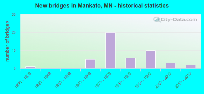
- New bridges - historical statistics
- 11930-1939
- 51960-1969
- 201970-1979
- 61980-1989
- 101990-1999
- 32000-2009
- 22010-2019

- Reconstructed bridges - Historical Statistics
- 11980-1989
- 01990-1999
- 12000-2009
- 12010-2019


- Bridge Condition - Deck
- 15.4%Very good
- 23.1%Good
- 42.3%Satisfactory
- 3.8%Fair
- 15.4%Poor

- Bridge Condition - Superstructure
- 23.1%Very good
- 11.5%Good
- 42.3%Satisfactory
- 23.1%Fair

- Bridge Condition - Substructure
- 23.1%Very good
- 38.5%Good
- 11.5%Satisfactory
- 23.1%Fair
- 3.8%Poor

- Bridge Condition - Channel
- 28.6%Good
- 28.6%Satisfactory
- 35.7%Fair
- 7.1%Serious

- Bridge Condition - Culverts
- 40.0%Good
- 60.0%Satisfactory
Find on map >> Show street view
Structure Number: 7009, Location: 1.0 MI E OF JCT TH 169 (Lat: 44.191217, Lng: -93.996269), Route carried "on" structure: US 14, Year Built: 1976, Status: Open, Structure Length: 5.66m (18.57ft), Average Daily Traffic: 18,500 (year 2017), Truck Traffic: 9%, Average Future Daily Traffic: 18,500 (year 2039), Design Load: HS 20, Features Intersected: CSAH 5
Minimum Vertical Clearance: 30+ m (98+ ft), Kilometerpoint: 0.000, Lanes on structure: 2, Lanes under structure: 6, Base Highway Network: Yes, Owner: State Highway Agency, Approaching Roadway Width: 11.3m (37.1ft), Skew: 1 degrees, Material/Design: Prestressed concrete, Design/Construction: Stringer/Multi-beam, Number Of Spans In Main Unit: 1, Number Of Approach Spans: 2, Length of Maximum Span: 33.8m (110.9ft), Curb-To-Curb Width: 12.3m (40.4ft), Out-to-Out Width: 13.5m (44.3ft)
Condition: Deck: Satisfactory, Superstructure: Fair, Substructure: Fair, Operating Rating: 58.1 metric tons, Method Used To Determine Operating Rating: Load Factor (LF), Inventory Rating: 31.0 metric tons, Method Used To Determine Inventory Rating: Load Factor (LF), Structural Evaluation: Somewhat better than minimum adequacy, Deck Geometry: Better than present minimum criteria, Underclear: Somewhat better than minimum adequacy, Approach Roadway Alignment: Equal to present desirable criteria, Designated Inspection Frequency: Every 24 months, Inspection Date: June 2021, Deck Structure Type: Concrete Cast-file-Place, Wearing Surface/Protective System: Wearing Surface: Low Slump Concrete, Deck Protection: Galvanized Reinforcing
Find on map >> Show street view
Structure Number: 701, Location: 1.0 MI E OF JCT TH 169 (Lat: 44.190961, Lng: -93.996217), Route carried "on" structure: US 14, Year Built: 1976, Status: Open, Structure Length: 5.66m (18.57ft), Average Daily Traffic: 19,500 (year 2019), Truck Traffic: 7%, Average Future Daily Traffic: 18,500 (year 2039), Design Load: HS 20, Features Intersected: CSAH 5
Minimum Vertical Clearance: 30+ m (98+ ft), Kilometerpoint: 0.000, Lanes on structure: 2, Lanes under structure: 6, Base Highway Network: Yes, Owner: State Highway Agency, Approaching Roadway Width: 11.6m (38.1ft), Skew: 1 degrees, Material/Design: Prestressed concrete, Design/Construction: Stringer/Multi-beam, Number Of Spans In Main Unit: 1, Number Of Approach Spans: 2, Length of Maximum Span: 33.8m (110.9ft), Curb-To-Curb Width: 12.3m (40.4ft), Out-to-Out Width: 13.5m (44.3ft)
Condition: Deck: Satisfactory, Superstructure: Fair, Substructure: Fair, Operating Rating: 57.1 metric tons, Method Used To Determine Operating Rating: Load Factor (LF), Inventory Rating: 39.2 metric tons, Method Used To Determine Inventory Rating: Load Factor (LF), Structural Evaluation: Somewhat better than minimum adequacy, Deck Geometry: Better than present minimum criteria, Underclear: Meets minimum limits, Approach Roadway Alignment: Equal to present desirable criteria, Designated Inspection Frequency: Every 24 months, Inspection Date: June 2021, Deck Structure Type: Concrete Cast-file-Place, Wearing Surface/Protective System: Wearing Surface: Low Slump Concrete, Deck Protection: Galvanized Reinforcing
Find on map >> Show street view
Structure Number: 7011, Location: 0.4 MI E OF JCT TH 169 (Lat: 44.191478, Lng: -94.009750), Route carried "on" structure: US 14, Year Built: 1976, Status: Open, Structure Length: 29.64m (97.24ft), Average Daily Traffic: 39,000 (year 2019), Truck Traffic: 7%, Average Future Daily Traffic: 37,000 (year 2039), Design Load: HS 20, Features Intersected: MINN RIVER; UP RR
Minimum Vertical Clearance: 30+ m (98+ ft), Kilometerpoint: 0.000, Lanes on structure: 5, Base Highway Network: Yes, Owner: State Highway Agency, Approaching Roadway Width: 27.1m (88.9ft), Skew: 32 degrees, Material/Design: Steel continuous, Design/Construction: Stringer/Multi-beam, Number Of Spans In Main Unit: 7, Length of Maximum Span: 52.1m (170.9ft), Curb-To-Curb Width: 26.2m (86.0ft), Out-to-Out Width: 28.3m (92.8ft)
Condition: Deck: Poor, Superstructure: Satisfactory, Substructure: Good, Channel: Satisfactory, Operating Rating: 65.9 metric tons, Method Used To Determine Operating Rating: Load Factor (LF), Inventory Rating: 39.5 metric tons, Method Used To Determine Inventory Rating: Load Factor (LF), Structural Evaluation: Equal to present minimum criteria, Deck Geometry: Superior to present desirable criteria, Underclear: Better than present minimum criteria, Waterway Adequacy: Superior to present desirable criteria, Approach Roadway Alignment: Equal to present desirable criteria, Designated Inspection Frequency: Every 24 months, Underwater Inspection Frequency: Every 60 months, Inspection Date: August 2021, Underwater Inspection Date: October 2020, Deck Structure Type: Concrete Cast-file-Place, Wearing Surface/Protective System: Wearing Surface: Low Slump Concrete, Deck Protection: Galvanized Reinforcing
Find on map >> Show street view
Structure Number: 7015, Location: 1.4 MI E OF JCT TH 169 (Lat: 44.190342, Lng: -93.988153), Route carried "on" structure: US 14, Year Built: 1977, Status: Open, Structure Length: 4.90m (16.08ft), Average Daily Traffic: 14,750 (year 2019), Truck Traffic: 10%, Average Future Daily Traffic: 16,250 (year 2039), Design Load: HS 20, Features Intersected: UP RR
Minimum Vertical Clearance: 30+ m (98+ ft), Kilometerpoint: 0.000, Lanes on structure: 3, Base Highway Network: Yes, Owner: State Highway Agency, Approaching Roadway Width: 14.9m (48.9ft), Skew: 1 degrees, Material/Design: Prestressed concrete, Design/Construction: Stringer/Multi-beam, Number Of Spans In Main Unit: 3, Length of Maximum Span: 17.4m (57.1ft), Curb-To-Curb Width: 16.0m (52.5ft), Out-to-Out Width: 17.2m (56.4ft)
Condition: Deck: Satisfactory, Superstructure: Fair, Substructure: Satisfactory, Operating Rating: 70.8 metric tons, Method Used To Determine Operating Rating: Load Factor (LF), Inventory Rating: 35.1 metric tons, Method Used To Determine Inventory Rating: Load Factor (LF), Structural Evaluation: Somewhat better than minimum adequacy, Deck Geometry: Equal to present minimum criteria, Underclear: Better than present minimum criteria, Approach Roadway Alignment: Equal to present desirable criteria, Length Of Structure Improvement: 1.65m (5.41ft), Designated Inspection Frequency: Every 24 months, Inspection Date: June 2021, Bridge Improvement Cost: $985,000,000, Total Project Cost: $639,000,000, Deck Structure Type: Concrete Cast-file-Place, Wearing Surface/Protective System: Wearing Surface: Low Slump Concrete, Deck Protection: Galvanized Reinforcing
Find on map >> Show street view
Structure Number: 7016, Location: 1.4 MI E OF JCT TH 169 (Lat: 44.190014, Lng: -93.988189), Route carried "on" structure: US 14, Year Built: 1977, Status: Open, Structure Length: 5.22m (17.13ft), Average Daily Traffic: 14,750 (year 2019), Truck Traffic: 8%, Average Future Daily Traffic: 16,250 (year 2039), Design Load: HS 20, Features Intersected: UP RR
Minimum Vertical Clearance: 30+ m (98+ ft), Kilometerpoint: 0.000, Lanes on structure: 3, Base Highway Network: Yes, Owner: State Highway Agency, Approaching Roadway Width: 14.9m (48.9ft), Skew: 1 degrees, Material/Design: Prestressed concrete, Design/Construction: Stringer/Multi-beam, Number Of Spans In Main Unit: 3, Length of Maximum Span: 20.6m (67.6ft), Curb-To-Curb Width: 16.0m (52.5ft), Out-to-Out Width: 17.2m (56.4ft)
Condition: Deck: Good, Superstructure: Satisfactory, Substructure: Good, Operating Rating: 71.5 metric tons, Method Used To Determine Operating Rating: Load Factor (LF), Inventory Rating: 42.8 metric tons, Method Used To Determine Inventory Rating: Load Factor (LF), Structural Evaluation: Equal to present minimum criteria, Deck Geometry: Equal to present minimum criteria, Underclear: Better than present minimum criteria, Approach Roadway Alignment: Equal to present desirable criteria, Length Of Structure Improvement: 1.74m (5.71ft), Designated Inspection Frequency: Every 24 months, Inspection Date: June 2021, Bridge Improvement Cost: $999,999,000, Total Project Cost: $681,000,000, Deck Structure Type: Concrete Cast-file-Place, Wearing Surface/Protective System: Wearing Surface: Low Slump Concrete, Deck Protection: Galvanized Reinforcing
Find on map >> Show street view
Structure Number: 7017, Location: AT THE JCT TH 22 (Lat: 44.188703, Lng: -93.982094), Route carried "on" structure: US 14, Year Built: 1977, Status: Open, Structure Length: 7.60m (24.93ft), Average Daily Traffic: 16,250 (year 2013), Truck Traffic: 10%, Average Future Daily Traffic: 16,250 (year 2039), Design Load: HS 20, Features Intersected: N RIVERFRONT DR
Minimum Vertical Clearance: 30+ m (98+ ft), Kilometerpoint: 0.000, Lanes on structure: 2, Lanes under structure: 4, Base Highway Network: Yes, Owner: State Highway Agency, Approaching Roadway Width: 11.3m (37.1ft), Skew: 1 degrees, Material/Design: Steel continuous, Design/Construction: Stringer/Multi-beam, Number Of Spans In Main Unit: 3, Length of Maximum Span: 41.1m (134.8ft), Curb-To-Curb Width: 12.3m (40.4ft), Out-to-Out Width: 13.5m (44.3ft)
Condition: Deck: Poor, Superstructure: Fair, Substructure: Fair, Operating Rating: 70.6 metric tons, Method Used To Determine Operating Rating: Load Factor (LF), Inventory Rating: 42.3 metric tons, Method Used To Determine Inventory Rating: Load Factor (LF), Structural Evaluation: Somewhat better than minimum adequacy, Deck Geometry: Better than present minimum criteria, Underclear: Equal to present desirable criteria, Approach Roadway Alignment: Equal to present desirable criteria, Designated Inspection Frequency: Every 12 months, Inspection Date: July 2021, Deck Structure Type: Concrete Cast-file-Place, Wearing Surface/Protective System: Wearing Surface: Low Slump Concrete, Deck Protection: Galvanized Reinforcing
Find on map >> Show street view
Structure Number: 7018, Location: AT THE JCT TH 22 (Lat: 44.188489, Lng: -93.982261), Route carried "on" structure: US 14, Year Built: 1977, Status: Open, Structure Length: 7.60m (24.93ft), Average Daily Traffic: 14,750 (year 2019), Truck Traffic: 8%, Average Future Daily Traffic: 16,250 (year 2039), Design Load: HS 20, Features Intersected: N RIVERFRONT DR
Minimum Vertical Clearance: 30+ m (98+ ft), Kilometerpoint: 0.000, Lanes on structure: 2, Lanes under structure: 4, Base Highway Network: Yes, Owner: State Highway Agency, Approaching Roadway Width: 11.3m (37.1ft), Skew: 1 degrees, Material/Design: Steel continuous, Design/Construction: Stringer/Multi-beam, Number Of Spans In Main Unit: 3, Length of Maximum Span: 41.1m (134.8ft), Curb-To-Curb Width: 12.3m (40.4ft), Out-to-Out Width: 13.5m (44.3ft)
Condition: Deck: Poor, Superstructure: Fair, Substructure: Fair, Operating Rating: 70.6 metric tons, Method Used To Determine Operating Rating: Load Factor (LF), Inventory Rating: 42.3 metric tons, Method Used To Determine Inventory Rating: Load Factor (LF), Structural Evaluation: Somewhat better than minimum adequacy, Deck Geometry: Better than present minimum criteria, Underclear: Equal to present desirable criteria, Approach Roadway Alignment: Equal to present desirable criteria, Designated Inspection Frequency: Every 12 months, Inspection Date: July 2021, Deck Structure Type: Concrete Cast-file-Place, Wearing Surface/Protective System: Wearing Surface: Low Slump Concrete, Deck Protection: Galvanized Reinforcing
Find on map >> Show street view
Structure Number: 7019, Location: 2.8 MI E OF JCT TH 169 (Lat: 44.179517, Lng: -93.966011), Route carried "on" structure: US 14, Year Built: 1976, Status: Open, Structure Length: 5.08m (16.67ft), Average Daily Traffic: 16,500 (year 2017), Truck Traffic: 8%, Average Future Daily Traffic: 16,500 (year 2039), Design Load: HS 20, Features Intersected: CSAH 3
Minimum Vertical Clearance: 30+ m (98+ ft), Kilometerpoint: 0.000, Lanes on structure: 2, Lanes under structure: 4, Base Highway Network: Yes, Owner: State Highway Agency, Approaching Roadway Width: 11.6m (38.1ft), Material/Design: Prestressed concrete, Design/Construction: Stringer/Multi-beam, Number Of Spans In Main Unit: 3, Length of Maximum Span: 23.5m (77.1ft), Curb-To-Curb Width: 12.3m (40.4ft), Out-to-Out Width: 13.5m (44.3ft)
Condition: Deck: Satisfactory, Superstructure: Satisfactory, Substructure: Good, Operating Rating: 60.4 metric tons, Method Used To Determine Operating Rating: Load Factor (LF), Inventory Rating: 28.2 metric tons, Method Used To Determine Inventory Rating: Load Factor (LF), Structural Evaluation: Equal to present minimum criteria, Deck Geometry: Better than present minimum criteria, Underclear: Meets minimum limits, Approach Roadway Alignment: Equal to present desirable criteria, Designated Inspection Frequency: Every 24 months, Inspection Date: July 2021, Deck Structure Type: Concrete Cast-file-Place, Wearing Surface/Protective System: Wearing Surface: Low Slump Concrete, Deck Protection: Galvanized Reinforcing
Find on map >> Show street view
Structure Number: 702, Location: 2.8 MI E OF JCT TH 169 (Lat: 44.179406, Lng: -93.966308), Route carried "on" structure: US 14, Year Built: 1976, Status: Open, Structure Length: 5.08m (16.67ft), Average Daily Traffic: 17,250 (year 2019), Truck Traffic: 4%, Average Future Daily Traffic: 16,500 (year 2039), Design Load: HS 20, Features Intersected: CSAH 3
Minimum Vertical Clearance: 30+ m (98+ ft), Kilometerpoint: 0.000, Lanes on structure: 2, Lanes under structure: 4, Base Highway Network: Yes, Owner: State Highway Agency, Approaching Roadway Width: 11.6m (38.1ft), Material/Design: Prestressed concrete, Design/Construction: Stringer/Multi-beam, Number Of Spans In Main Unit: 3, Length of Maximum Span: 23.5m (77.1ft), Curb-To-Curb Width: 12.3m (40.4ft), Out-to-Out Width: 13.5m (44.3ft)
Condition: Deck: Good, Superstructure: Satisfactory, Substructure: Satisfactory, Operating Rating: 60.4 metric tons, Method Used To Determine Operating Rating: Load Factor (LF), Inventory Rating: 28.2 metric tons, Method Used To Determine Inventory Rating: Load Factor (LF), Structural Evaluation: Equal to present minimum criteria, Deck Geometry: Better than present minimum criteria, Underclear: Meets minimum limits, Approach Roadway Alignment: Equal to present desirable criteria, Designated Inspection Frequency: Every 24 months, Inspection Date: July 2021, Deck Structure Type: Concrete Cast-file-Place, Wearing Surface/Protective System: Wearing Surface: Low Slump Concrete, Deck Protection: Galvanized Reinforcing
Find on map >> Show street view
Structure Number: 7023, Location: AT THE JCT TH 169 (Lat: 44.191625, Lng: -94.016853), Route carried "on" structure: US 14, Year Built: 1976, Status: Open, Structure Length: 10.40m (34.12ft), Average Daily Traffic: 39,000 (year 2019), Truck Traffic: 7%, Average Future Daily Traffic: 37,000 (year 2039), Design Load: HS 20, Features Intersected: TH 169
Minimum Vertical Clearance: 30+ m (98+ ft), Kilometerpoint: 0.000, Lanes on structure: 6, Lanes under structure: 5, Base Highway Network: Yes, Owner: State Highway Agency, Approaching Roadway Width: 31.7m (104.0ft), Skew: 32 degrees, Material/Design: Prestressed concrete, Design/Construction: Stringer/Multi-beam, Number Of Spans In Main Unit: 4, Length of Maximum Span: 32.8m (107.6ft), Curb-To-Curb Width: 28.5m (93.5ft), Out-to-Out Width: 31.7m (104.0ft)
Condition: Deck: Satisfactory, Superstructure: Satisfactory, Substructure: Poor, Operating Rating: 49.4 metric tons, Method Used To Determine Operating Rating: Load Factor (LF), Inventory Rating: 29.6 metric tons, Method Used To Determine Inventory Rating: Load Factor (LF), Structural Evaluation: Meets minimum limits, Deck Geometry: Better than present minimum criteria, Underclear: Better than present minimum criteria, Approach Roadway Alignment: Equal to present desirable criteria, Designated Inspection Frequency: Every 24 months, Inspection Date: May 2021, Deck Structure Type: Concrete Cast-file-Place, Wearing Surface/Protective System: Wearing Surface: Low Slump Concrete
Find on map >> Show street view
Structure Number: 7026, Location: AT THE JCT TH 22 (Lat: 44.175003, Lng: -93.948975), Route carried "on" structure: US 14, Year Built: 1996, Status: Open, Structure Length: 7.01m (23.00ft), Average Daily Traffic: 12,300 (year 2019), Truck Traffic: 4%, Average Future Daily Traffic: 11,200 (year 2039), Design Load: HS 25 or greater, Features Intersected: TH 22
Minimum Vertical Clearance: 30+ m (98+ ft), Kilometerpoint: 0.000, Lanes on structure: 2, Lanes under structure: 4, Base Highway Network: Yes, Owner: State Highway Agency, Approaching Roadway Width: 12.5m (41.0ft), Material/Design: Prestressed concrete, Design/Construction: Stringer/Multi-beam, Number Of Spans In Main Unit: 2, Length of Maximum Span: 34.4m (112.9ft), Curb-To-Curb Width: 12.8m (42.0ft), Out-to-Out Width: 13.8m (45.3ft)
Condition: Deck: Good, Superstructure: Satisfactory, Substructure: Good, Operating Rating: 72.2 metric tons, Method Used To Determine Operating Rating: Load Factor (LF), Inventory Rating: 44.7 metric tons, Method Used To Determine Inventory Rating: Load Factor (LF), Structural Evaluation: Equal to present minimum criteria, Deck Geometry: Equal to present desirable criteria, Underclear: Better than present minimum criteria, Approach Roadway Alignment: Equal to present desirable criteria, Designated Inspection Frequency: Every 24 months, Inspection Date: July 2020, Deck Structure Type: Concrete Cast-file-Place, Wearing Surface/Protective System: Wearing Surface: Low Slump Concrete, Deck Protection: Epoxy Coated Reinforcing
Find on map >> Show street view
Structure Number: 7029, Location: AT THE JCT TH 66 (Lat: 44.159886, Lng: -94.020364), Route carried "on" structure: US 169, Year Built: 1992, Status: Open, Structure Length: 6.63m (21.75ft), Average Daily Traffic: 19,700 (year 2019), Truck Traffic: 13%, Average Future Daily Traffic: 16,600 (year 2039), Design Load: HS 25 or greater, Features Intersected: S RIVERFRONT DR
Minimum Vertical Clearance: 30+ m (98+ ft), Kilometerpoint: 0.000, Lanes on structure: 4, Lanes under structure: 6, Base Highway Network: Yes, Owner: State Highway Agency, Approaching Roadway Width: 26.8m (87.9ft), Skew: 34 degrees, Material/Design: Prestressed concrete, Design/Construction: Stringer/Multi-beam, Number Of Spans In Main Unit: 2, Length of Maximum Span: 36.1m (118.4ft), Curb-To-Curb Width: 24.4m (80.1ft), Out-to-Out Width: 29.4m (96.5ft)
Condition: Deck: Satisfactory, Superstructure: Good, Substructure: Satisfactory, Operating Rating: 76.7 metric tons, Method Used To Determine Operating Rating: Load Factor (LF), Inventory Rating: 41.2 metric tons, Method Used To Determine Inventory Rating: Load Factor (LF), Structural Evaluation: Equal to present minimum criteria, Deck Geometry: Superior to present desirable criteria, Underclear: Equal to present minimum criteria, Approach Roadway Alignment: Equal to present desirable criteria, Designated Inspection Frequency: Every 24 months, Inspection Date: August 2020, Deck Structure Type: Concrete Cast-file-Place, Wearing Surface/Protective System: Wearing Surface: Low Slump Concrete, Deck Protection: Epoxy Coated Reinforcing
Find on map >> Show street view
Structure Number: 703, Location: AT JCT TH 66 IN MANKATO (Lat: 44.158231, Lng: -94.024553), Route carried "on" structure: US 169, Year Built: 1992, Status: Open, Structure Length: 4.93m (16.17ft), Average Daily Traffic: 23,569 (year 2019), Truck Traffic: 11%, Average Future Daily Traffic: 22,200 (year 2039), Design Load: HS 25 or greater, Features Intersected: SIBLEY ST
Minimum Vertical Clearance: 30+ m (98+ ft), Kilometerpoint: 0.000, Lanes on structure: 5, Lanes under structure: 2, Base Highway Network: Yes, Owner: State Highway Agency, Approaching Roadway Width: 28.0m (91.9ft), Skew: 31 degrees, Material/Design: Concrete continuous, Design/Construction: Slab, Number Of Spans In Main Unit: 3, Length of Maximum Span: 19.1m (62.7ft), Curb-To-Curb Width: 27.4m (89.9ft), Out-to-Out Width: 30.2m (99.1ft)
Condition: Deck: Satisfactory, Superstructure: Satisfactory, Substructure: Very good, Operating Rating: 67.6 metric tons, Method Used To Determine Operating Rating: Load Factor (LF), Inventory Rating: 40.5 metric tons, Method Used To Determine Inventory Rating: Load Factor (LF), Structural Evaluation: Equal to present minimum criteria, Deck Geometry: Superior to present desirable criteria, Underclear: Equal to present minimum criteria, Approach Roadway Alignment: Equal to present desirable criteria, Designated Inspection Frequency: Every 24 months, Inspection Date: August 2020, Deck Structure Type: Concrete Cast-file-Place, Wearing Surface/Protective System: Wearing Surface: Epoxy Overlay, Deck Protection: Epoxy Coated Reinforcing
Find on map >> Show street view
Structure Number: 7033, Location: 1.6 MI N OF JCT TH 14 (Lat: 44.198842, Lng: -93.949142), Route carried "on" structure: State highway 22, Year Built: 1999, Status: Open, Structure Length: 0.81m (2.66ft), Average Daily Traffic: 9,800 (year 2019), Truck Traffic: 4%, Average Future Daily Traffic: 8,900 (year 2039), Design Load: HS 25 or greater, Features Intersected: SAKATAH STATE TRAIL
Minimum Vertical Clearance: 30+ m (98+ ft), Kilometerpoint: 0.000, Lanes on structure: 4, Base Highway Network: Yes, Owner: State Highway Agency, Approaching Roadway Width: 24.4m (80.1ft), Skew: 12 degrees, Material/Design: Concrete, Design/Construction: Culvert, Number Of Spans In Main Unit: 1, Length of Maximum Span: 7.2m (23.6ft)
Condition: Culverts: Good, Operating Rating: 97.0 metric tons, Method Used To Determine Operating Rating: Load Factor (LF), Inventory Rating: 58.4 metric tons, Method Used To Determine Inventory Rating: Load Factor (LF), Structural Evaluation: Better than present minimum criteria, Approach Roadway Alignment: Equal to present desirable criteria, Designated Inspection Frequency: Every 48 months, Inspection Date: April 2020
Find on map >> Show street view
Structure Number: 7035, Location: 2.1 MI N OF JCT TH 14 (Lat: 44.201319, Lng: -93.971686), Route carried "on" structure: County highway 57, Year Built: 1978, Status: Open, Structure Length: 16.59m (54.43ft), Average Daily Traffic: 2,650 (year 2016), Truck Traffic: 7%, Average Future Daily Traffic: 2,650 (year 2039), Design Load: HS 20, Features Intersected: STREAM; TRAIL
Minimum Vertical Clearance: 30+ m (98+ ft), Kilometerpoint: 0.000, Lanes on structure: 3, Owner: County Highway Agency, Approaching Roadway Width: 14.9m (48.9ft), Material/Design: Steel continuous, Design/Construction: Frame, Number Of Spans In Main Unit: 3, Length of Maximum Span: 85.4m (280.2ft), Curb or Sidewalk Widths: Left: 1.8m (5.9ft), Right: 0.0m, Curb-To-Curb Width: 16.7m (54.8ft), Out-to-Out Width: 19.8m (65.0ft)
Condition: Deck: Satisfactory, Superstructure: Satisfactory, Substructure: Good, Channel: Satisfactory, Operating Rating: 49.8 metric tons, Method Used To Determine Operating Rating: Load Factor (LF), Inventory Rating: 29.8 metric tons, Method Used To Determine Inventory Rating: Load Factor (LF), Structural Evaluation: Equal to present minimum criteria, Deck Geometry: Superior to present desirable criteria, Waterway Adequacy: Superior to present desirable criteria, Approach Roadway Alignment: Equal to present desirable criteria, Designated Inspection Frequency: Every 24 months, Inspection Date: October 2020, Deck Structure Type: Concrete Cast-file-Place, Wearing Surface/Protective System: Wearing Surface: Low Slump Concrete, Deck Protection: Epoxy Coated Reinforcing
Find on map >> Show street view
Structure Number: 7036, Location: 4.4 MI N OF JCT TH 14 (Lat: 44.229775, Lng: -93.958878), Route carried "on" structure: State highway 22, Year Built: 1978, Status: Open, Structure Length: 10.96m (35.96ft), Average Daily Traffic: 12,500 (year 2019), Truck Traffic: 3%, Average Future Daily Traffic: 7,500 (year 2039), Design Load: HS 20, Features Intersected: DME RR; STREAM
Minimum Vertical Clearance: 30+ m (98+ ft), Kilometerpoint: 0.000, Lanes on structure: 2, Base Highway Network: Yes, Owner: State Highway Agency, Approaching Roadway Width: 13.4m (44.0ft), Material/Design: Prestressed concrete, Design/Construction: Stringer/Multi-beam, Number Of Spans In Main Unit: 3, Length of Maximum Span: 37.4m (122.7ft), Curb-To-Curb Width: 14.3m (46.9ft), Out-to-Out Width: 15.4m (50.5ft)
Condition: Deck: Satisfactory, Superstructure: Very good, Substructure: Good, Channel: Fair, Operating Rating: 58.8 metric tons, Method Used To Determine Operating Rating: Load Factor (LF), Inventory Rating: 34.9 metric tons, Method Used To Determine Inventory Rating: Load Factor (LF), Structural Evaluation: Better than present minimum criteria, Deck Geometry: Superior to present desirable criteria, Underclear: Equal to present desirable criteria, Waterway Adequacy: Equal to present desirable criteria, Approach Roadway Alignment: Equal to present desirable criteria, Designated Inspection Frequency: Every 24 months, Inspection Date: August 2021, Deck Structure Type: Concrete Cast-file-Place, Wearing Surface/Protective System: Wearing Surface: Monolithic Concrete, Deck Protection: Epoxy Coated Reinforcing
Find on map >> Show street view
Structure Number: 7041, Location: 0.4 MI W OF JCT TH 66 (Lat: 44.156892, Lng: -94.027803), Route carried "on" structure: US 169, Year Built: 1987, Status: Open, Structure Length: 3.09m (10.14ft), Average Daily Traffic: 23,569 (year 2019), Truck Traffic: 11%, Average Future Daily Traffic: 22,200 (year 2039), Design Load: HS 20, Features Intersected: OFF RAMP FROM US 169
Minimum Vertical Clearance: 30+ m (98+ ft), Kilometerpoint: 0.000, Lanes on structure: 2, Lanes under structure: 2, Base Highway Network: Yes, Owner: State Highway Agency, Approaching Roadway Width: 25.0m (82.0ft), Skew: 33 degrees, Material/Design: Prestressed concrete, Design/Construction: Stringer/Multi-beam, Number Of Spans In Main Unit: 1, Length of Maximum Span: 29.0m (95.1ft), Curb-To-Curb Width: 24.8m (81.4ft), Out-to-Out Width: 26.4m (86.6ft)
Condition: Deck: Satisfactory, Superstructure: Satisfactory, Substructure: Good, Operating Rating: 87.2 metric tons, Method Used To Determine Operating Rating: Load Factor (LF), Inventory Rating: 29.4 metric tons, Method Used To Determine Inventory Rating: Load Factor (LF), Structural Evaluation: Equal to present minimum criteria, Deck Geometry: Superior to present desirable criteria, Underclear: Better than present minimum criteria, Approach Roadway Alignment: Equal to present desirable criteria, Length Of Structure Improvement: 1.13m (3.71ft), Designated Inspection Frequency: Every 24 months, Inspection Date: August 2021, Bridge Improvement Cost: $999,999,000, Deck Structure Type: Concrete Cast-file-Place, Wearing Surface/Protective System: Wearing Surface: Low Slump Concrete, Deck Protection: Epoxy Coated Reinforcing
Find on map >> Show street view
Structure Number: 7042, Location: 0.1 MI SE OF JCT TH 169 (Lat: 44.169131, Lng: -94.003300), Route carried "on" structure: US 169, Year Built: 1985, Status: Open, Structure Length: 28.43m (93.27ft), Average Daily Traffic: 20,700 (year 2019), Truck Traffic: 4%, Average Future Daily Traffic: 21,500 (year 2039), Design Load: HS 20, Features Intersected: MINN R, UP RR; STREET
Minimum Vertical Clearance: 30+ m (98+ ft), Kilometerpoint: 0.000, Lanes on structure: 6, Lanes under structure: 4, Owner: State Highway Agency, Approaching Roadway Width: 28.7m (94.2ft), Skew: 20 degrees, Material/Design: Steel continuous, Design/Construction: Stringer/Multi-beam, Number Of Spans In Main Unit: 6, Length of Maximum Span: 52.4m (171.9ft), Curb or Sidewalk Widths: Left: 3.7m (12.1ft), Right: 3.7m (12.1ft), Curb-To-Curb Width: 23.2m (76.1ft), Out-to-Out Width: 29.4m (96.5ft)
Condition: Deck: Poor, Superstructure: Satisfactory, Substructure: Fair, Channel: Good, Operating Rating: 66.5 metric tons, Method Used To Determine Operating Rating: Load Factor (LF), Inventory Rating: 39.6 metric tons, Method Used To Determine Inventory Rating: Load Factor (LF), Structural Evaluation: Somewhat better than minimum adequacy, Deck Geometry: Meets minimum limits, Underclear: Somewhat better than minimum adequacy, Waterway Adequacy: Superior to present desirable criteria, Approach Roadway Alignment: Equal to present desirable criteria, Designated Inspection Frequency: Every 12 months, Underwater Inspection Frequency: Every 60 months, Inspection Date: June 2021, Underwater Inspection Date: October 2020, Deck Structure Type: Concrete Cast-file-Place, Wearing Surface/Protective System: Wearing Surface: Low Slump Concrete, Deck Protection: Epoxy Coated Reinforcing
Find on map >> Show street view
Structure Number: 7512, Location: 1.2 MI N OF JCT CSAH 35 (Lat: 44.080483, Lng: -94.008575), Route carried "on" structure: County highway 16, Year Built: 1965, Status: Open, Structure Length: 6.77m (22.21ft), Average Daily Traffic: 1,100 (year 2013), Average Future Daily Traffic: 1,100 (year 2039), Design Load: H 20, Features Intersected: LE SUEUR RIVER
Minimum Vertical Clearance: 30+ m (98+ ft), Kilometerpoint: 0.000, Lanes on structure: 2, Owner: County Highway Agency, Approaching Roadway Width: 11.0m (36.1ft), Material/Design: Steel continuous, Design/Construction: Stringer/Multi-beam, Number Of Spans In Main Unit: 3, Length of Maximum Span: 25.6m (84.0ft), Curb-To-Curb Width: 9.1m (29.9ft), Out-to-Out Width: 10.0m (32.8ft)
Condition: Deck: Fair, Superstructure: Fair, Substructure: Very good, Channel: Satisfactory, Operating Rating: 45.3 metric tons, Method Used To Determine Operating Rating: Load Factor (LF), Inventory Rating: 27.1 metric tons, Method Used To Determine Inventory Rating: Load Factor (LF), Structural Evaluation: Somewhat better than minimum adequacy, Deck Geometry: Somewhat better than minimum adequacy, Waterway Adequacy: Equal to present desirable criteria, Approach Roadway Alignment: Somewhat better than minimum adequacy, Length Of Structure Improvement: 2.26m (7.41ft), Designated Inspection Frequency: Every 24 months, Inspection Date: November 2020, Bridge Improvement Cost: $721,000,000, Roadway Improvement Cost: $43,000,000, Total Project Cost: $658,000,000, Deck Structure Type: Concrete Cast-file-Place, Wearing Surface/Protective System: Wearing Surface: Monolithic Concrete
Find on map >> Show street view
Structure Number: 7526, Location: 1.0 MI SW OF N CO LINE (Lat: 44.228539, Lng: -93.984192), Route carried "on" structure: County highway 5, Year Built: 1969, Year Reconstructed: 2017, Status: Open, Structure Length: 1.01m (3.31ft), Average Daily Traffic: 6,111 (year 2019), Truck Traffic: 4%, Average Future Daily Traffic: 10,050 (year 2039), Design Load: HL 93, Features Intersected: STREAM
Minimum Vertical Clearance: 30+ m (98+ ft), Kilometerpoint: 0.000, Lanes on structure: 2, Owner: County Highway Agency, Approaching Roadway Width: 14.1m (46.3ft), Material/Design: Concrete, Design/Construction: Slab, Number Of Spans In Main Unit: 1, Length of Maximum Span: 9.1m (29.9ft), Curb-To-Curb Width: 14.1m (46.3ft), Out-to-Out Width: 14.8m (48.6ft)
Condition: Deck: Good, Superstructure: Good, Substructure: Good, Channel: Fair, Operating Rating: 37.9 metric tons, Method Used To Determine Operating Rating: Load and Resistance Factor Rating (LRFR) rating reported by rating factor(RF) method using HL-93 loadings, Inventory Rating: 29.5 metric tons, Method Used To Determine Inventory Rating: Load and Resistance Factor Rating (LRFR) rating reported by rating factor(RF) method using HL-93 loadings, Structural Evaluation: Better than present minimum criteria, Deck Geometry: Superior to present desirable criteria, Waterway Adequacy: Equal to present minimum criteria, Approach Roadway Alignment: Meets minimum limits, Designated Inspection Frequency: Every 12 months, Inspection Date: September 2021, Bridge Improvement Cost: $250,000,000, Roadway Improvement Cost: $90,000,000, Total Project Cost: $340,000,000 ( Estimate for 2017), Deck Structure Type: Concrete Cast-file-Place, Wearing Surface/Protective System: Wearing Surface: Monolithic Concrete, Deck Protection: Epoxy Coated Reinforcing
Find on map >> Show street view
Structure Number: 7555, Location: 2.4 MI NW OF JCT TH 22 (Lat: 44.084769, Lng: -93.988822), Route carried "on" structure: County highway 8, Year Built: 1987, Status: Open, Structure Length: 7.25m (23.79ft), Average Daily Traffic: 630 (year 2013), Average Future Daily Traffic: 630 (year 2039), Design Load: HS 20, Features Intersected: LE SUEUR RIVER
Minimum Vertical Clearance: 30+ m (98+ ft), Kilometerpoint: 0.000, Lanes on structure: 2, Owner: County Highway Agency, Approaching Roadway Width: 9.8m (32.2ft), Skew: 3 degrees, Material/Design: Prestressed concrete, Design/Construction: Stringer/Multi-beam, Number Of Spans In Main Unit: 3, Length of Maximum Span: 23.6m (77.4ft), Curb-To-Curb Width: 9.8m (32.2ft), Out-to-Out Width: 10.8m (35.4ft)
Condition: Deck: Good, Superstructure: Good, Substructure: Good, Channel: Fair, Operating Rating: 60.8 metric tons, Method Used To Determine Operating Rating: Load Factor (LF), Inventory Rating: 35.6 metric tons, Method Used To Determine Inventory Rating: Load Factor (LF), Structural Evaluation: Better than present minimum criteria, Deck Geometry: Equal to present minimum criteria, Waterway Adequacy: Equal to present desirable criteria, Approach Roadway Alignment: Better than present minimum criteria, Designated Inspection Frequency: Every 24 months, Inspection Date: October 2020, Deck Structure Type: Concrete Cast-file-Place, Wearing Surface/Protective System: Wearing Surface: Monolithic Concrete
Find on map >> Show street view
Structure Number: 7566, Location: 1.5 MI SE OF JCT TH 22 (Lat: 44.109261, Lng: -93.945472), Route carried "on" structure: County highway 90, Year Built: 1998, Status: Open, Structure Length: 8.00m (26.25ft), Average Daily Traffic: 1,050 (year 2013), Average Future Daily Traffic: 1,050 (year 2039), Design Load: HS 25 or greater, Features Intersected: LE SUEUR RIVER
Minimum Vertical Clearance: 30+ m (98+ ft), Kilometerpoint: 0.000, Lanes on structure: 2, Base Highway Network: Yes, Owner: County Highway Agency, Approaching Roadway Width: 13.4m (44.0ft), Skew: 2 degrees, Material/Design: Prestressed concrete, Design/Construction: Stringer/Multi-beam, Number Of Spans In Main Unit: 3, Length of Maximum Span: 26.3m (86.3ft), Curb or Sidewalk Widths: Left: 3.0m (9.8ft), Right: 0.0m, Curb-To-Curb Width: 13.4m (44.0ft), Out-to-Out Width: 17.8m (58.4ft)
Condition: Deck: Good, Superstructure: Very good, Substructure: Very good, Channel: Good, Operating Rating: 65.8 metric tons, Method Used To Determine Operating Rating: Load Factor (LF), Inventory Rating: 39.4 metric tons, Method Used To Determine Inventory Rating: Load Factor (LF), Structural Evaluation: Equal to present desirable criteria, Deck Geometry: Equal to present desirable criteria, Waterway Adequacy: Superior to present desirable criteria, Approach Roadway Alignment: Better than present minimum criteria, Designated Inspection Frequency: Every 24 months, Inspection Date: October 2020, Deck Structure Type: Concrete Cast-file-Place, Wearing Surface/Protective System: Wearing Surface: Monolithic Concrete, Deck Protection: Epoxy Coated Reinforcing
Find on map >> Show street view
Structure Number: 7571, Location: 0.2 MI E OF JCT TH 22 (Lat: 44.196183, Lng: -93.945969), Route carried "on" structure: County highway 26, Year Built: 1998, Status: Open, Structure Length: 2.27m (7.45ft), Average Daily Traffic: 2,200 (year 2017), Average Future Daily Traffic: 2,200 (year 2039), Design Load: HS 25 or greater, Features Intersected: SAKATAH TRAIL
Minimum Vertical Clearance: 30+ m (98+ ft), Kilometerpoint: 0.000, Lanes on structure: 2, Owner: County Highway Agency, Approaching Roadway Width: 13.7m (44.9ft), Skew: 2 degrees, Material/Design: Prestressed concrete, Design/Construction: Stringer/Multi-beam, Number Of Spans In Main Unit: 1, Length of Maximum Span: 21.1m (69.2ft), Curb-To-Curb Width: 14.7m (48.2ft), Out-to-Out Width: 14.7m (48.2ft)
Condition: Deck: Very good, Superstructure: Very good, Substructure: Very good, Operating Rating: 71.0 metric tons, Method Used To Determine Operating Rating: Load Factor (LF), Inventory Rating: 42.3 metric tons, Method Used To Determine Inventory Rating: Load Factor (LF), Structural Evaluation: Equal to present desirable criteria, Deck Geometry: Superior to present desirable criteria, Approach Roadway Alignment: Equal to present desirable criteria, Designated Inspection Frequency: Every 24 months, Inspection Date: September 2020, Deck Structure Type: Concrete Cast-file-Place, Wearing Surface/Protective System: Wearing Surface: Monolithic Concrete, Deck Protection: Epoxy Coated Reinforcing
Find on map >> Show street view
Structure Number: 7577, Location: 0.3 MI S OF JCT TH 14 (Lat: 44.175219, Lng: -93.968903), Route carried "on" structure: County highway 82, Year Built: 2003, Status: Open, Structure Length: 13.52m (44.36ft), Average Daily Traffic: 16,100 (year 2013), Average Future Daily Traffic: 16,100 (year 2039), Design Load: HS 25 or greater, Features Intersected: THOMPSON RAVINE
Minimum Vertical Clearance: 30+ m (98+ ft), Kilometerpoint: 0.000, Lanes on structure: 4, Owner: County Highway Agency, Approaching Roadway Width: 20.7m (67.9ft), Skew: 20 degrees, Material/Design: Prestressed concrete, Design/Construction: Stringer/Multi-beam, Number Of Spans In Main Unit: 3, Length of Maximum Span: 45.7m (149.9ft), Curb or Sidewalk Widths: Left: 1.8m (5.9ft), Right: 3.0m (9.8ft), Curb-To-Curb Width: 20.7m (67.9ft), Out-to-Out Width: 27.5m (90.2ft)
Condition: Deck: Very good, Superstructure: Very good, Substructure: Very good, Channel: Fair, Operating Rating: 81.0 metric tons, Method Used To Determine Operating Rating: Load Factor (LF), Inventory Rating: 33.7 metric tons, Method Used To Determine Inventory Rating: Load Factor (LF), Structural Evaluation: Equal to present desirable criteria, Deck Geometry: Superior to present desirable criteria, Waterway Adequacy: Superior to present desirable criteria, Approach Roadway Alignment: Equal to present desirable criteria, Length Of Structure Improvement: 4.11m (13.48ft), Designated Inspection Frequency: Every 24 months, Inspection Date: October 2020, Bridge Improvement Cost: $999,999,000, Roadway Improvement Cost: $1,000, Total Project Cost: $1,000, Deck Structure Type: Concrete Cast-file-Place, Wearing Surface/Protective System: Wearing Surface: Low Slump Concrete, Deck Protection: Epoxy Coated Reinforcing
Find on map >> Show street view
Structure Number: 7589, Location: 0.16 MI N of JCT CSAH 3 (Lat: 44.183914, Lng: -93.925797), Route carried "on" structure: County highway 12, Year Built: 2010, Status: Open, Structure Length: 6.66m (21.85ft), Average Daily Traffic: 1,750 (year 2013), Average Future Daily Traffic: 1,750 (year 2039), Design Load: HL 93, Features Intersected: TRAIL; DM E RR
Minimum Vertical Clearance: 30+ m (98+ ft), Kilometerpoint: 0.000, Lanes on structure: 3, Owner: County Highway Agency, Approaching Roadway Width: 17.1m (56.1ft), Skew: 4 degrees, Material/Design: Prestressed concrete, Design/Construction: Stringer/Multi-beam, Number Of Spans In Main Unit: 2, Length of Maximum Span: 38.1m (125.0ft), Curb or Sidewalk Widths: Left: 0.0m, Right: 3.7m (12.1ft), Curb-To-Curb Width: 18.7m (61.4ft), Out-to-Out Width: 23.7m (77.8ft)
Condition: Deck: Very good, Superstructure: Very good, Substructure: Very good, Operating Rating: 51.8 metric tons, Method Used To Determine Operating Rating: Load and Resistance Factor Rating (LRFR) rating reported by rating factor(RF) method using HL-93 loadings, Inventory Rating: 39.9 metric tons, Method Used To Determine Inventory Rating: Load and Resistance Factor Rating (LRFR) rating reported by rating factor(RF) method using HL-93 loadings, Structural Evaluation: Equal to present desirable criteria, Deck Geometry: Superior to present desirable criteria, Underclear: Superior to present desirable criteria, Approach Roadway Alignment: Equal to present desirable criteria, Designated Inspection Frequency: Every 24 months, Inspection Date: October 2020, Deck Structure Type: Concrete Cast-file-Place, Wearing Surface/Protective System: Wearing Surface: Low Slump Concrete, Deck Protection: Epoxy Coated Reinforcing
Find on map >> Show street view
Structure Number: 7J09, Location: 1.0 MI S OF STADIUM RD (Lat: 44.130533, Lng: -94.004294), Route carried "on" structure: County highway 16, Year Built: 2004, Status: Open, Structure Length: 0.84m (2.76ft), Average Daily Traffic: 2,004 (year 2019), Truck Traffic: 4%, Average Future Daily Traffic: 1,900 (year 2039), Design Load: HS 25 or greater, Features Intersected: STREAM
Minimum Vertical Clearance: 30+ m (98+ ft), Kilometerpoint: 0.000, Lanes on structure: 2, Owner: County Highway Agency, Approaching Roadway Width: 9.8m (32.2ft), Skew: 6 degrees, Material/Design: Concrete, Design/Construction: Culvert, Number Of Spans In Main Unit: 1, Length of Maximum Span: 8.4m (27.6ft)
Condition: Channel: Good, Culverts: Good, Operating Rating: 58.8 metric tons, Method Used To Determine Operating Rating: Assigned rating based on Load Factor Design (LFD) reported in metric tons, Inventory Rating: 39.2 metric tons, Method Used To Determine Inventory Rating: Assigned rating based on Load Factor Design (LFD) reported in metric tons, Structural Evaluation: Better than present minimum criteria, Waterway Adequacy: Equal to present desirable criteria, Approach Roadway Alignment: Equal to present desirable criteria, Length Of Structure Improvement: 0.40m (1.31ft), Designated Inspection Frequency: Every 24 months, Inspection Date: October 2020, Bridge Improvement Cost: $88,000,000, Roadway Improvement Cost: $1,000, Total Project Cost: $1,000
Find on map >> Show street view
Structure Number: 40J14, Location: 4 MI S OF KASOTA (Lat: 44.240864, Lng: -94.004406), Route carried "on" structure: County highway 159, Year Built: 2005, Status: Open, Structure Length: 0.92m (3.02ft), Average Daily Traffic: 20 (year 2005), Average Future Daily Traffic: 20 (year 2029), Design Load: HS 25 or greater, Features Intersected: STREAM
Minimum Vertical Clearance: 30+ m (98+ ft), Kilometerpoint: 0.000, Lanes on structure: 2, Owner: Town or Township Highway Agency, Approaching Roadway Width: 8.5m (27.9ft), Material/Design: Concrete, Design/Construction: Culvert, Number Of Spans In Main Unit: 2, Length of Maximum Span: 4.3m (14.1ft)
Condition: Channel: Fair, Culverts: Satisfactory, Operating Rating: 58.8 metric tons, Method Used To Determine Operating Rating: Assigned rating based on Load Factor Design (LFD) reported in metric tons, Inventory Rating: 39.2 metric tons, Method Used To Determine Inventory Rating: Assigned rating based on Load Factor Design (LFD) reported in metric tons, Structural Evaluation: Equal to present minimum criteria, Waterway Adequacy: Equal to present minimum criteria, Approach Roadway Alignment: Equal to present desirable criteria, Length Of Structure Improvement: 0.46m (1.51ft), Designated Inspection Frequency: Every 24 months, Inspection Date: October 2020, Bridge Improvement Cost: $68,000,000, Roadway Improvement Cost: $1,000, Total Project Cost: $1,000
Find on map >> Show street view
Structure Number: 5513, Location: 0.1 MI NW OF JCT TH 169 (Lat: 44.152922, Lng: -94.063378), Route carried "on" structure: State highway 68, Year Built: 1936, Year Reconstructed: 2013, Status: Open, Structure Length: 3.97m (13.02ft), Average Daily Traffic: 2,600 (year 2019), Truck Traffic: 7%, Average Future Daily Traffic: 2,450 (year 2039), Design Load: HL 93, Features Intersected: UP RR
Minimum Vertical Clearance: 30+ m (98+ ft), Kilometerpoint: 0.000, Lanes on structure: 2, Owner: State Highway Agency, Approaching Roadway Width: 11.0m (36.1ft), Skew: 2 degrees, Material/Design: Prestressed concrete, Design/Construction: Stringer/Multi-beam, Number Of Spans In Main Unit: 3, Length of Maximum Span: 13.7m (44.9ft), Curb or Sidewalk Widths: Left: 0.0m, Right: 1.8m (5.9ft), Curb-To-Curb Width: 11.0m (36.1ft), Out-to-Out Width: 11.9m (39.0ft)
Condition: Deck: Very good, Superstructure: Very good, Substructure: Good, Operating Rating: 87.2 metric tons, Method Used To Determine Operating Rating: Load and Resistance Factor Rating (LRFR) rating reported by rating factor(RF) method using HL-93 loadings, Inventory Rating: 44.1 metric tons, Method Used To Determine Inventory Rating: Load and Resistance Factor Rating (LRFR) rating reported by rating factor(RF) method using HL-93 loadings, Structural Evaluation: Better than present minimum criteria, Deck Geometry: Somewhat better than minimum adequacy, Underclear: Meets minimum limits, Approach Roadway Alignment: Equal to present minimum criteria, Length Of Structure Improvement: 1.28m (4.20ft), Designated Inspection Frequency: Every 24 months, Inspection Date: July 2021, Bridge Improvement Cost: $789,000,000, Roadway Improvement Cost: $29,000,000, Total Project Cost: $447,000,000, Deck Structure Type: Concrete Cast-file-Place, Wearing Surface/Protective System: Wearing Surface: Monolithic Concrete, Deck Protection: Epoxy Coated Reinforcing
Find on map >> Show street view
Structure Number: 9098, Location: AT N CO LINE IN MANKATO (Lat: 44.163608, Lng: -94.018211), Route carried "on" structure: US 169, Year Built: 1960, Year Reconstructed: 1992, Status: Open, Structure Length: 48.59m (159.42ft), Average Daily Traffic: 31,500 (year 2019), Truck Traffic: 9%, Average Future Daily Traffic: 32,500 (year 2039), Design Load: HS 25 or greater, Features Intersected: MINN R, UP RR; STR
Minimum Vertical Clearance: 5.24m (17.19ft), Kilometerpoint: 0.000, Lanes on structure: 6, Lanes under structure: 4, Base Highway Network: Yes, Owner: State Highway Agency, Approaching Roadway Width: 28.3m (92.8ft), Skew: 30 degrees, Material/Design: Prestressed concrete, Design/Construction: Stringer/Multi-beam, Number Of Spans In Main Unit: 19, Length of Maximum Span: 37.8m (124.0ft), Curb or Sidewalk Widths: Left: 0.0m, Right: 2.4m (7.9ft), Curb-To-Curb Width: 30.8m (101.0ft), Out-to-Out Width: 34.2m (112.2ft)
Condition: Deck: Satisfactory, Superstructure: Satisfactory, Substructure: Fair, Channel: Satisfactory, Operating Rating: 66.6 metric tons, Method Used To Determine Operating Rating: Load Factor (LF), Inventory Rating: 36.6 metric tons, Method Used To Determine Inventory Rating: Load Factor (LF), Structural Evaluation: Somewhat better than minimum adequacy, Deck Geometry: Superior to present desirable criteria, Underclear: Somewhat better than minimum adequacy, Waterway Adequacy: Superior to present desirable criteria, Approach Roadway Alignment: Equal to present desirable criteria, Length Of Structure Improvement: 14.81m (48.59ft), Designated Inspection Frequency: Every 24 months, Underwater Inspection Frequency: Every 60 months, Inspection Date: May 2020, Underwater Inspection Date: October 2020, Bridge Improvement Cost: $999,999,000, Deck Structure Type: Concrete Cast-file-Place, Wearing Surface/Protective System: Wearing Surface: Low Slump Concrete, Deck Protection: Epoxy Coated Reinforcing
Find on map >> Show street view
Structure Number: 93487, Location: 1.0 MI S OF JCT CSAH 18 (Lat: 44.275956, Lng: -93.906547), Route carried "on" structure: County highway 19, Year Built: 1974, Status: Open, Structure Length: 0.63m (2.07ft), Average Daily Traffic: 1,450 (year 2017), Average Future Daily Traffic: 1,450 (year 2039), Design Load: HS 20, Features Intersected: SHANASKA CREEK
Minimum Vertical Clearance: 30+ m (98+ ft), Kilometerpoint: 0.000, Lanes on structure: 2, Owner: County Highway Agency, Approaching Roadway Width: 10.4m (34.1ft), Material/Design: Concrete, Design/Construction: Culvert, Number Of Spans In Main Unit: 1, Number Of Approach Spans: 1, Length of Maximum Span: 3.9m (12.8ft)
Condition: Channel: Good, Culverts: Satisfactory, Operating Rating: 53.9 metric tons, Method Used To Determine Operating Rating: Assigned ratings based on Allowable Stress Design (ASD) reported in metric tons, Inventory Rating: 35.9 metric tons, Method Used To Determine Inventory Rating: Assigned ratings based on Allowable Stress Design (ASD) reported in metric tons, Structural Evaluation: Equal to present minimum criteria, Waterway Adequacy: Better than present minimum criteria, Approach Roadway Alignment: Equal to present desirable criteria, Designated Inspection Frequency: Every 48 months, Inspection Date: October 2018
Find on map >> Show street view
Structure Number: 95147, Location: 0.1 MI SE OF JCT CSAH 1 (Lat: 44.147497, Lng: -94.024711), Route carried "on" structure: County highway 525, Year Built: 1980, Status: Open, Structure Length: 0.65m (2.13ft), Average Daily Traffic: 9 (year 1975), Average Future Daily Traffic: 9 (year 2029), Design Load: HS 20, Features Intersected: INDIAN CREEK
Minimum Vertical Clearance: 30+ m (98+ ft), Kilometerpoint: 0.000, Lanes on structure: 2, Owner: Town or Township Highway Agency, Approaching Roadway Width: 8.5m (27.9ft), Skew: 2 degrees, Material/Design: Concrete, Design/Construction: Culvert, Number Of Spans In Main Unit: 2, Length of Maximum Span: 2.4m (7.9ft)
Condition: Channel: Serious, Culverts: Satisfactory, Operating Rating: 53.9 metric tons, Method Used To Determine Operating Rating: Assigned ratings based on Allowable Stress Design (ASD) reported in metric tons, Inventory Rating: 35.9 metric tons, Method Used To Determine Inventory Rating: Assigned ratings based on Allowable Stress Design (ASD) reported in metric tons, Structural Evaluation: Equal to present minimum criteria, Waterway Adequacy: Meets minimum limits, Approach Roadway Alignment: Somewhat better than minimum adequacy, Designated Inspection Frequency: Every 24 months, Inspection Date: October 2020
Find on map >> Show street view
Structure Number: 7009, Location: 1.0 MI E OF JCT TH 169 (Lat: 44.191217, Lng: -93.996269), Route carried "under" structure: County highway 5, Year Built: 1976, Structure Length: 0. m, Average Daily Traffic: 7,600 (year 2009), Features Intersected: CSAH 5, Facility Carried by Structure: US 14
Minimum Vertical Clearance: 5.70m (18.70ft), Kilometerpoint: 0.000, Lanes on structure: 2, Lanes under structure: 6, Material/Design: Prestressed concrete, Design/Construction: Stringer/Multi-beam, Length of Maximum Span: 33.8m (110.9ft)
Find on map >> Show street view
Structure Number: 701, Location: 1.0 MI E OF JCT TH 169 (Lat: 44.190961, Lng: -93.996217), Route carried "under" structure: County highway 5, Year Built: 1976, Structure Length: 0. m, Average Daily Traffic: 14,000 (year 2005), Features Intersected: CSAH 5, Facility Carried by Structure: US 14
Minimum Vertical Clearance: 5.06m (16.60ft), Kilometerpoint: 0.000, Lanes on structure: 2, Lanes under structure: 6, Material/Design: Prestressed concrete, Design/Construction: Stringer/Multi-beam, Length of Maximum Span: 33.8m (110.9ft)
Find on map >> Show street view
Structure Number: 7017, Location: AT THE JCT TH 22 (Lat: 44.188703, Lng: -93.982094), Route carried "under" structure: State highway 10, Year Built: 1977, Structure Length: 0. m, Average Daily Traffic: 9,800 (year 2019), Truck Traffic: 4%, Features Intersected: N RIVERFRONT DR, Facility Carried by Structure: US 14
Minimum Vertical Clearance: 5.36m (17.59ft), Kilometerpoint: 0.000, Lanes on structure: 2, Lanes under structure: 4, Material/Design: Steel continuous, Design/Construction: Stringer/Multi-beam, Length of Maximum Span: 41.1m (134.8ft)
Find on map >> Show street view
Structure Number: 7018, Location: AT THE JCT TH 22 (Lat: 44.188489, Lng: -93.982261), Route carried "under" structure: City street 101, Year Built: 1977, Structure Length: 0. m, Average Daily Traffic: 13,600 (year 2019), Truck Traffic: 4%, Features Intersected: N RIVERFRONT DR, Facility Carried by Structure: US 14
Minimum Vertical Clearance: 5.85m (19.19ft), Kilometerpoint: 0.000, Lanes on structure: 2, Lanes under structure: 4, Material/Design: Steel continuous, Design/Construction: Stringer/Multi-beam, Length of Maximum Span: 41.1m (134.8ft)
Find on map >> Show street view
Structure Number: 7019, Location: 2.8 MI E OF JCT TH 169 (Lat: 44.179517, Lng: -93.966011), Route carried "under" structure: County highway 3, Year Built: 1976, Structure Length: 0. m, Average Daily Traffic: 10,800 (year 2019), Truck Traffic: 4%, Features Intersected: CSAH 3, Facility Carried by Structure: US 14
Minimum Vertical Clearance: 4.88m (16.01ft), Kilometerpoint: 0.000, Lanes on structure: 2, Lanes under structure: 4, Material/Design: Prestressed concrete, Design/Construction: Stringer/Multi-beam, Length of Maximum Span: 23.5m (77.1ft)
Find on map >> Show street view
Structure Number: 702, Location: 2.8 MI E OF JCT TH 169 (Lat: 44.179406, Lng: -93.966308), Route carried "under" structure: County highway 82, Year Built: 1976, Structure Length: 0. m, Average Daily Traffic: 7,900 (year 2005), Features Intersected: CSAH 3, Facility Carried by Structure: US 14
Minimum Vertical Clearance: 5.24m (17.19ft), Kilometerpoint: 0.000, Lanes on structure: 2, Lanes under structure: 4, Material/Design: Prestressed concrete, Design/Construction: Stringer/Multi-beam, Length of Maximum Span: 23.5m (77.1ft)
Find on map >> Show street view
Structure Number: 7023, Location: AT THE JCT TH 169 (Lat: 44.191625, Lng: -94.016853), Route carried "under" structure: US 169, Year Built: 1976, Structure Length: 0. m, Average Daily Traffic: 17,300 (year 2019), Truck Traffic: 10%, Features Intersected: TH 169, Facility Carried by Structure: US 14
Minimum Vertical Clearance: 4.97m (16.31ft), Kilometerpoint: 0.000, Lanes on structure: 6, Lanes under structure: 5, Material/Design: Prestressed concrete, Design/Construction: Stringer/Multi-beam, Length of Maximum Span: 32.8m (107.6ft)
Find on map >> Show street view
Structure Number: 7025, Location: AT THE JCT TH 22 (Lat: 44.175250, Lng: -93.948989), Route carried "under" structure: State highway 22, Year Built: 1996, Structure Length: 0. m, Average Daily Traffic: 20,007 (year 2019), Truck Traffic: 5%, Features Intersected: TH 22, Facility Carried by Structure: US 14
Minimum Vertical Clearance: 5.06m (16.60ft), Kilometerpoint: 0.000, Lanes on structure: 2, Lanes under structure: 4, Material/Design: Prestressed concrete, Design/Construction: Stringer/Multi-beam, Length of Maximum Span: 34.4m (112.9ft)
Find on map >> Show street view
Structure Number: 7026, Location: AT THE JCT TH 22 (Lat: 44.175003, Lng: -93.948975), Route carried "under" structure: State highway 22, Year Built: 1996, Structure Length: 0. m, Average Daily Traffic: 20,007 (year 2019), Truck Traffic: 5%, Features Intersected: TH 22, Facility Carried by Structure: US 14
Minimum Vertical Clearance: 4.88m (16.01ft), Kilometerpoint: 0.000, Lanes on structure: 2, Lanes under structure: 4, Material/Design: Prestressed concrete, Design/Construction: Stringer/Multi-beam, Length of Maximum Span: 34.4m (112.9ft)
Find on map >> Show street view
Structure Number: 7029, Location: AT THE JCT TH 66 (Lat: 44.159886, Lng: -94.020364), Route carried "under" structure: City street 154, Year Built: 1992, Structure Length: 0. m, Average Daily Traffic: 22,900 (year 2009), Truck Traffic: 13%, Features Intersected: S RIVERFRONT DR, Facility Carried by Structure: US 169
Minimum Vertical Clearance: 5.21m (17.09ft), Kilometerpoint: 0.000, Lanes on structure: 4, Lanes under structure: 6, Material/Design: Prestressed concrete, Design/Construction: Stringer/Multi-beam, Length of Maximum Span: 36.1m (118.4ft)
Find on map >> Show street view
Structure Number: 703, Location: AT JCT TH 66 IN MANKATO (Lat: 44.158231, Lng: -94.024553), Route carried "under" structure: City street 154, Year Built: 1992, Structure Length: 0. m, Average Daily Traffic: 1,703 (year 2019), Truck Traffic: 4%, Features Intersected: SIBLEY ST, Facility Carried by Structure: US 169
Minimum Vertical Clearance: 5.09m (16.70ft), Kilometerpoint: 0.000, Lanes on structure: 5, Lanes under structure: 2, Material/Design: Concrete continuous, Design/Construction: Slab, Length of Maximum Span: 19.1m (62.7ft)
Find on map >> Show street view
Structure Number: 7041, Location: 0.4 MI W OF JCT TH 66 (Lat: 44.156892, Lng: -94.027803), Route carried "under" structure: Ramp US 1364, Year Built: 1987, Structure Length: 0. m, Average Daily Traffic: 800 (year 1994), Features Intersected: OFF RAMP FROM US 169, Facility Carried by Structure: US 169
Minimum Vertical Clearance: 5.30m (17.39ft), Kilometerpoint: 0.000, Lanes on structure: 2, Lanes under structure: 2, Material/Design: Prestressed concrete, Design/Construction: Stringer/Multi-beam, Length of Maximum Span: 29.0m (95.1ft)
Find on map >> Show street view
Structure Number: 7042, Location: 0.1 MI SE OF JCT TH 169 (Lat: 44.169131, Lng: -94.003300), Route carried "under" structure: City street 101, Year Built: 1985, Structure Length: 0. m, Average Daily Traffic: 21,400 (year 2005), Features Intersected: MINN R, UP RR; STREET, Facility Carried by Structure: UNU 169
Minimum Vertical Clearance: 5.03m (16.50ft), Kilometerpoint: 0.000, Lanes on structure: 4, Lanes under structure: 4, Material/Design: Steel continuous, Design/Construction: Stringer/Multi-beam, Length of Maximum Span: 52.4m (171.9ft)
Find on map >> Show street view
Structure Number: 7587, Location: 3.7 MI E JCT CSAH5; TH14 (Lat: 44.173125, Lng: -93.923606), Route carried "under" structure: US 14, Year Built: 2012, Structure Length: 0. m, Average Daily Traffic: 20,800 (year 2019), Truck Traffic: 13%, Features Intersected: US 14, Facility Carried by Structure: CSAH 12
Minimum Vertical Clearance: 5.03m (16.50ft), Kilometerpoint: 0.000, Lanes under structure: 6, Material/Design: Prestressed concrete, Design/Construction: Stringer/Multi-beam, Length of Maximum Span: 35.4m (116.1ft)
Find on map >> Show street view
Structure Number: 9098, Location: AT N CO LINE IN MANKATO (Lat: 44.163608, Lng: -94.018211), Route carried "under" structure: Ramp US 4610, Year Built: 1960, Structure Length: 0. m, Average Daily Traffic: 2,000 (year 1994), Features Intersected: MINN R, UP RR; STR, Facility Carried by Structure: US 169
Minimum Vertical Clearance: 5.30m (17.39ft), Kilometerpoint: 0.000, Lanes on structure: 6, Lanes under structure: 2, Material/Design: Prestressed concrete, Design/Construction: Stringer/Multi-beam, Length of Maximum Span: 37.8m (124.0ft)
Find on map >> Show street view
Structure Number: 9098, Location: AT N CO LINE IN MANKATO (Lat: 44.163608, Lng: -94.018211), Route carried "under" structure: City street 101, Year Built: 1960, Structure Length: 0. m, Average Daily Traffic: 2,600 (year 2005), Features Intersected: MINN R, UP RR; STR, Facility Carried by Structure: US 169
Minimum Vertical Clearance: 5.49m (18.01ft), Kilometerpoint: 0.000, Lanes on structure: 6, Lanes under structure: 2, Material/Design: Prestressed concrete, Design/Construction: Stringer/Multi-beam, Length of Maximum Span: 37.8m (124.0ft)