Bridge Statistics for Lott, Texas (TX)
Condition, Traffic, Stress, Structural Evaluation, Project Costs
- National Bridge Inventory (NBI) Statistics
- 10Number of bridges
- 59ft / 18.1mTotal length
- $3,004,000Total costs
- 7,421Total average daily traffic
- 830Total average daily truck traffic
- 11,580Total future (year 2033) average daily traffic
- National Bridge Inventory (NBI) Registered Bridges for Lott
- No street view available for this location
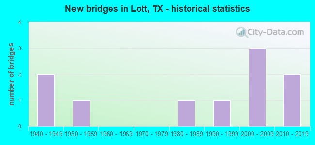
- New bridges - historical statistics
- 21940-1949
- 11950-1959
- 11980-1989
- 11990-1999
- 32000-2009
- 22010-2019

- Reconstructed bridges - Historical Statistics
- 11970-1979
- 01980-1989
- 01990-1999
- 02000-2009
- 12010-2019


- Bridge Condition - Deck
- 16.7%Very good
- 50.0%Good
- 33.3%Satisfactory

- Bridge Condition - Superstructure
- 16.7%Very good
- 66.7%Good
- 16.7%Satisfactory

- Bridge Condition - Substructure
- 16.7%Very good
- 16.7%Good
- 33.3%Satisfactory
- 33.3%Fair

- Bridge Condition - Channel
- 50.0%Good
- 10.0%Satisfactory
- 30.0%Fair
- 10.0%Poor

- Bridge Condition - Culverts
- 75.0%Satisfactory
- 25.0%Fair
Find on map >> Show street view
Structure Number: 9074002090305, Location: 1.05 MI S OF SH 320 (Lat: 31.189228, Lng: -97.030689), Route carried "on" structure: US 77, Year Built: 1954, Year Reconstructed: 2015, Status: Open, Structure Length: 0.98m (3.22ft), Average Daily Traffic: 3,863 (year 2020), Truck Traffic: 13%, Average Future Daily Traffic: 6,370 (year 2033), Features Intersected: TRIB OF COTTONWOOD CK
Minimum Vertical Clearance: 30+ m (98+ ft), Kilometerpoint: 23.213, Lanes on structure: 3, Owner: State Highway Agency, Approaching Roadway Width: 15.5m (50.9ft), Material/Design: Concrete, Design/Construction: Culvert, Number Of Spans In Main Unit: 5, Length of Maximum Span: 1.8m (5.9ft)
Condition: Channel: Good, Culverts: Satisfactory, Operating Rating: 39.9 metric tons, Method Used To Determine Operating Rating: Load Factor (LF), Inventory Rating: 23.6 metric tons, Method Used To Determine Inventory Rating: Load Factor (LF), Structural Evaluation: Equal to present minimum criteria, Waterway Adequacy: Equal to present minimum criteria, Approach Roadway Alignment: Equal to present desirable criteria, Length Of Structure Improvement: 1.83m (6.00ft), Designated Inspection Frequency: Every 24 months, Inspection Date: December 2020, Bridge Improvement Cost: $200,000, Roadway Improvement Cost: $100,000, Total Project Cost: $400,000
Find on map >> Show street view
Structure Number: 90740059001019, Location: 2.05 MI NE OF US 77 (Lat: 31.228469, Lng: -97.017578), Route carried "on" structure: State highway 320, Year Built: 1944, Year Reconstructed: 1979, Status: Open, Structure Length: 0.70m (2.30ft), Average Daily Traffic: 1,443 (year 2020), Truck Traffic: 14%, Average Future Daily Traffic: 2,230 (year 2033), Design Load: H 15, Features Intersected: PERRY CREEK
Minimum Vertical Clearance: 30+ m (98+ ft), Kilometerpoint: 7.820, Lanes on structure: 2, Owner: State Highway Agency, Approaching Roadway Width: 12.8m (42.0ft), Material/Design: Concrete, Design/Construction: Culvert, Number Of Spans In Main Unit: 3, Length of Maximum Span: 2.1m (6.9ft)
Condition: Channel: Fair, Culverts: Satisfactory, Operating Rating: 39.9 metric tons, Method Used To Determine Operating Rating: Load Factor (LF), Inventory Rating: 23.6 metric tons, Method Used To Determine Inventory Rating: Load Factor (LF), Structural Evaluation: Equal to present minimum criteria, Waterway Adequacy: Equal to present minimum criteria, Approach Roadway Alignment: Equal to present desirable criteria, Length Of Structure Improvement: 1.83m (6.00ft), Designated Inspection Frequency: Every 24 months, Inspection Date: December 2020, Bridge Improvement Cost: $200,000, Roadway Improvement Cost: $100,000, Total Project Cost: $400,000
Find on map >> Show street view
Structure Number: 90740059002015, Location: 3.60 MI SW OF US 77 (Lat: 31.170556, Lng: -97.082375), Route carried "on" structure: State highway 320, Year Built: 1947, Status: Open, Structure Length: 4.57m (14.99ft), Average Daily Traffic: 1,575 (year 2020), Truck Traffic: 8%, Average Future Daily Traffic: 2,410 (year 2033), Design Load: H 20, Features Intersected: LIVE OAK CREEK
Minimum Vertical Clearance: 30+ m (98+ ft), Kilometerpoint: 5.818, Lanes on structure: 2, Owner: State Highway Agency, Approaching Roadway Width: 10.4m (34.1ft), Material/Design: Concrete, Design/Construction: Slab, Number Of Spans In Main Unit: 6, Length of Maximum Span: 7.6m (24.9ft), Curb-To-Curb Width: 7.8m (25.6ft), Out-to-Out Width: 9.1m (29.9ft)
Condition: Deck: Good, Superstructure: Good, Substructure: Fair, Channel: Fair, Operating Rating: 44.4 metric tons, Method Used To Determine Operating Rating: Load Factor (LF), Inventory Rating: 26.3 metric tons, Method Used To Determine Inventory Rating: Load Factor (LF), Structural Evaluation: Somewhat better than minimum adequacy, Deck Geometry: Meets minimum limits, Waterway Adequacy: Equal to present minimum criteria, Approach Roadway Alignment: Equal to present desirable criteria, Length Of Structure Improvement: 6.40m (21.00ft), Designated Inspection Frequency: Every 24 months, Inspection Date: January 2021, Bridge Improvement Cost: $700,000, Roadway Improvement Cost: $200,000, Total Project Cost: $1,100,000, Deck Structure Type: Concrete Cast-file-Place, Wearing Surface/Protective System: Wearing Surface: Bituminous
Find on map >> Show street view
Structure Number: 90740AA0393001, Location: 0.80 MI NE OF US 77 (Lat: 31.233719, Lng: -97.031644), Route carried "on" structure: County highway 412, Year Built: 2010, Status: Posted for load, Structure Length: 0.62m (2.03ft), Average Daily Traffic: 200 (year 2016), Average Future Daily Traffic: 215 (year 2036), Features Intersected: TRIB LITTLE DEER #106
Minimum Vertical Clearance: 30+ m (98+ ft), Kilometerpoint: 1.287, Lanes on structure: 1, Owner: County Highway Agency, Approaching Roadway Width: 5.5m (18.0ft), Material/Design: Steel, Design/Construction: Culvert, Number Of Spans In Main Unit: 2, Length of Maximum Span: 2.7m (8.9ft)
Condition: Channel: Poor, Culverts: Fair, Operating Rating: 32.7 metric tons, Method Used To Determine Operating Rating: No rating analysis performed, Inventory Rating: 24.5 metric tons, Method Used To Determine Inventory Rating: No rating analysis performed, Structural Evaluation: Somewhat better than minimum adequacy, Waterway Adequacy: Meets minimum limits, Approach Roadway Alignment: Equal to present desirable criteria, Length Of Structure Improvement: 1.83m (6.00ft), Designated Inspection Frequency: Every 24 months, Inspection Date: January 2020, Bridge Improvement Cost: $167,000, Roadway Improvement Cost: $41,000, Total Project Cost: $208,000
Find on map >> Show street view
Structure Number: 90740AA0396002, Location: 0.95 MI NW OF US 77 (Lat: 31.217447, Lng: -97.050675), Route carried "on" structure: County highway 473, Year Built: 2005, Status: Open, Structure Length: 1.19m (3.90ft), Average Daily Traffic: 55 (year 2016), Average Future Daily Traffic: 35 (year 2036), Features Intersected: BONE BRANCH #105
Minimum Vertical Clearance: 30+ m (98+ ft), Kilometerpoint: 3.862, Lanes on structure: 1, Owner: County Highway Agency, Approaching Roadway Width: 4.3m (14.1ft), Material/Design: Steel, Design/Construction: Stringer/Multi-beam, Number Of Spans In Main Unit: 1, Length of Maximum Span: 11.6m (38.1ft), Curb-To-Curb Width: 7.7m (25.3ft), Out-to-Out Width: 7.8m (25.6ft)
Condition: Deck: Good, Superstructure: Good, Substructure: Good, Channel: Good, Operating Rating: 46.3 metric tons, Method Used To Determine Operating Rating: Load Factor (LF), Inventory Rating: 27.2 metric tons, Method Used To Determine Inventory Rating: Load Factor (LF), Structural Evaluation: Equal to present minimum criteria, Deck Geometry: Equal to present minimum criteria, Waterway Adequacy: High priority of corrective action, Approach Roadway Alignment: Equal to present desirable criteria, Length Of Structure Improvement: 1.83m (6.00ft), Designated Inspection Frequency: Every 24 months, Inspection Date: January 2020, Bridge Improvement Cost: $167,000, Roadway Improvement Cost: $41,000, Total Project Cost: $208,000, Deck Structure Type: Concrete Cast-file-Place
Find on map >> Show street view
Structure Number: 90740AA0404001, Location: 0.35 MILES NE OF US 77 (Lat: 31.167975, Lng: -97.015147), Route carried "on" structure: County highway 578, Year Built: 2017, Status: Open, Structure Length: 1.52m (4.99ft), Average Daily Traffic: 55 (year 2015), Average Future Daily Traffic: 90 (year 2037), Design Load: HL 93, Features Intersected: COTTONWOOD CREEK
Minimum Vertical Clearance: 30+ m (98+ ft), Kilometerpoint: 0.805, Lanes on structure: 2, Owner: County Highway Agency, Approaching Roadway Width: 4.9m (16.1ft), Material/Design: Prestressed concrete, Design/Construction: Box Beam or Girders - Multiple, Number Of Spans In Main Unit: 1, Length of Maximum Span: 14.9m (48.9ft), Curb-To-Curb Width: 7.3m (24.0ft), Out-to-Out Width: 7.9m (25.9ft)
Condition: Deck: Very good, Superstructure: Very good, Substructure: Very good, Channel: Good, Operating Rating: 54.4 metric tons, Method Used To Determine Operating Rating: Assigned ratings based on Load and Resistance Factor Design (LRFD) reported in metric tons, Inventory Rating: 32.7 metric tons, Method Used To Determine Inventory Rating: Assigned ratings based on Load and Resistance Factor Design (LRFD) reported in metric tons, Structural Evaluation: Equal to present desirable criteria, Deck Geometry: Equal to present minimum criteria, Waterway Adequacy: Equal to present minimum criteria, Approach Roadway Alignment: Equal to present desirable criteria, Designated Inspection Frequency: Every 24 months, Inspection Date: January 2020, Deck Structure Type: Concrete Precast Panels
Find on map >> Show street view
Structure Number: 90740AA0407002, Location: 1.05 MI E OF SH 320 (Lat: 31.161694, Lng: -97.078211), Route carried "on" structure: County highway 489, Year Built: 2000, Status: Open, Structure Length: 2.13m (6.99ft), Average Daily Traffic: 55 (year 2016), Average Future Daily Traffic: 30 (year 2036), Features Intersected: LIVE OAK CREEK #2026
Minimum Vertical Clearance: 30+ m (98+ ft), Kilometerpoint: 6.357, Lanes on structure: 1, Owner: County Highway Agency, Approaching Roadway Width: 4.3m (14.1ft), Material/Design: Steel continuous, Design/Construction: Stringer/Multi-beam, Number Of Spans In Main Unit: 1, Number Of Approach Spans: 2, Length of Maximum Span: 12.2m (40.0ft), Curb-To-Curb Width: 7.2m (23.6ft), Out-to-Out Width: 7.9m (25.9ft)
Condition: Deck: Good, Superstructure: Good, Substructure: Satisfactory, Channel: Satisfactory, Operating Rating: 54.4 metric tons, Method Used To Determine Operating Rating: Allowable Stress (AS), Inventory Rating: 32.7 metric tons, Method Used To Determine Inventory Rating: Allowable Stress (AS), Structural Evaluation: Equal to present minimum criteria, Deck Geometry: Somewhat better than minimum adequacy, Waterway Adequacy: Meets minimum limits, Approach Roadway Alignment: Equal to present desirable criteria, Length Of Structure Improvement: 2.74m (8.99ft), Designated Inspection Frequency: Every 24 months, Inspection Date: January 2020, Bridge Improvement Cost: $251,000, Roadway Improvement Cost: $62,000, Total Project Cost: $313,000, Deck Structure Type: Concrete Cast-file-Place, Wearing Surface/Protective System: Wearing Surface: Gravel
Find on map >> Show street view
Structure Number: 90740AA0435001, Location: 0.35 MI NW OF FM 431 (Lat: 31.149569, Lng: -97.029058), Route carried "on" structure: County highway 341, Year Built: 1988, Status: Open, Structure Length: 1.28m (4.20ft), Average Daily Traffic: 65 (year 2015), Average Future Daily Traffic: 75 (year 2037), Features Intersected: TRIB OF POND CR #2079
Minimum Vertical Clearance: 30+ m (98+ ft), Kilometerpoint: 1.448, Lanes on structure: 1, Owner: County Highway Agency, Approaching Roadway Width: 4.3m (14.1ft), Material/Design: Steel, Design/Construction: Culvert, Number Of Spans In Main Unit: 4, Length of Maximum Span: 2.7m (8.9ft)
Condition: Channel: Good, Culverts: Satisfactory, Operating Rating: 39.9 metric tons, Method Used To Determine Operating Rating: Load Factor (LF), Inventory Rating: 23.6 metric tons, Method Used To Determine Inventory Rating: Load Factor (LF), Structural Evaluation: Equal to present minimum criteria, Waterway Adequacy: Meets minimum limits, Approach Roadway Alignment: Equal to present desirable criteria, Designated Inspection Frequency: Every 24 months, Inspection Date: January 2020
Find on map >> Show street view
Structure Number: 90740AA0483001, Location: 2.40 MI NE OF US 77 (Lat: 31.187825, Lng: -96.985892), Route carried "on" structure: County highway 405, Year Built: 2002, Status: Open, Structure Length: 2.38m (7.81ft), Average Daily Traffic: 55 (year 2015), Average Future Daily Traffic: 75 (year 2037), Features Intersected: BELL BR #2055
Minimum Vertical Clearance: 30+ m (98+ ft), Kilometerpoint: 0.644, Lanes on structure: 2, Owner: County Highway Agency, Approaching Roadway Width: 4.3m (14.1ft), Material/Design: Steel, Design/Construction: Stringer/Multi-beam, Number Of Spans In Main Unit: 2, Length of Maximum Span: 11.9m (39.0ft), Curb-To-Curb Width: 7.7m (25.3ft), Out-to-Out Width: 7.9m (25.9ft)
Condition: Deck: Satisfactory, Superstructure: Satisfactory, Substructure: Satisfactory, Channel: Good, Operating Rating: 37.2 metric tons, Method Used To Determine Operating Rating: Allowable Stress (AS), Inventory Rating: 23.6 metric tons, Method Used To Determine Inventory Rating: Allowable Stress (AS), Structural Evaluation: Equal to present minimum criteria, Deck Geometry: Equal to present minimum criteria, Waterway Adequacy: Better than present minimum criteria, Approach Roadway Alignment: Equal to present desirable criteria, Designated Inspection Frequency: Every 24 months, Inspection Date: January 2020, Deck Structure Type: Concrete Cast-file-Place
Find on map >> Show street view
Structure Number: 90740AA0484001, Location: 2.20 MI SW OF FM 2027 (Lat: 31.238964, Lng: -96.995542), Route carried "on" structure: County highway 408, Year Built: 1999, Status: Open, Structure Length: 2.74m (8.99ft), Average Daily Traffic: 55 (year 2016), Average Future Daily Traffic: 50 (year 2036), Design Load: HS 25 or greater, Features Intersected: PERRY CREEK #2054
Minimum Vertical Clearance: 30+ m (98+ ft), Kilometerpoint: 2.414, Lanes on structure: 2, Owner: County Highway Agency, Approaching Roadway Width: 4.3m (14.1ft), Material/Design: Steel, Design/Construction: Stringer/Multi-beam, Number Of Spans In Main Unit: 1, Number Of Approach Spans: 2, Length of Maximum Span: 12.2m (40.0ft), Curb-To-Curb Width: 7.1m (23.3ft), Out-to-Out Width: 7.9m (25.9ft)
Condition: Deck: Satisfactory, Superstructure: Good, Substructure: Fair, Channel: Fair, Operating Rating: 54.4 metric tons, Method Used To Determine Operating Rating: Assigned rating based on Load Factor Design (LFD) reported in metric tons, Inventory Rating: 32.7 metric tons, Method Used To Determine Inventory Rating: Assigned rating based on Load Factor Design (LFD) reported in metric tons, Structural Evaluation: Somewhat better than minimum adequacy, Deck Geometry: Somewhat better than minimum adequacy, Waterway Adequacy: Meets minimum limits, Approach Roadway Alignment: Equal to present desirable criteria, Length Of Structure Improvement: 2.74m (8.99ft), Designated Inspection Frequency: Every 24 months, Inspection Date: January 2020, Bridge Improvement Cost: $250,000, Roadway Improvement Cost: $62,000, Total Project Cost: $375,000, Deck Structure Type: Concrete Cast-file-Place