Bridge Statistics for Lost Hills, California (CA)
Condition, Traffic, Stress, Structural Evaluation, Project Costs
- National Bridge Inventory (NBI) Statistics
- 20Number of bridges
- 272ft / 83.3mTotal length
- $1,567,000Total costs
- 262,091Total average daily traffic
- 84,844Total average daily truck traffic
- National Bridge Inventory (NBI) Registered Bridges for Lost Hills
- No street view available for this location
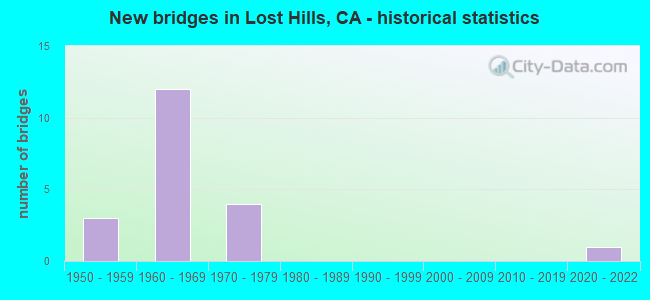
- New bridges - historical statistics
- 31950-1959
- 121960-1969
- 41970-1979
- 12020-2022

- Reconstructed bridges - Historical Statistics
- 11990-1999
- 02000-2009
- 02010-2019
- 22020-2022


- Bridge Condition - Deck
- 78.6%Good
- 14.3%Fair
- 7.1%Poor

- Bridge Condition - Superstructure
- 85.7%Good
- 14.3%Fair

- Bridge Condition - Substructure
- 28.6%Good
- 7.1%Satisfactory
- 57.1%Fair
- 7.1%Poor

- Bridge Condition - Channel
- 20.0%Very good
- 20.0%Good
- 30.0%Satisfactory
- 30.0%Fair
Find on map >> Show street view
Structure Number: 50 0027, Location: 06-KER-046-35.13 (Lat: 35.615878, Lng: -119.607092), Route carried "on" structure: State highway 46, Year Built: 1956, Status: Open, Structure Length: 1.43m (4.69ft), Average Daily Traffic: 6,100 (year 2009), Truck Traffic: 39%, Average Future Daily Traffic: 9,610 (year 2042), Design Load: HS 20, Features Intersected: GOOSE LAKE CANAL
Minimum Vertical Clearance: 30+ m (98+ ft), Kilometerpoint: 35.130, Lanes on structure: 2, Base Highway Network: Yes (, Subroute: 1), Owner: State Highway Agency, Approaching Roadway Width: 7.3m (24.0ft), Material/Design: Prestressed concrete, Design/Construction: Stringer/Multi-beam, Number Of Spans In Main Unit: 1, Length of Maximum Span: 13.7m (44.9ft), Curb-To-Curb Width: 12.2m (40.0ft), Out-to-Out Width: 12.8m (42.0ft)
Condition: Deck: Good, Superstructure: Good, Substructure: Poor, Channel: Fair, Operating Rating: 41.5 metric tons, Method Used To Determine Operating Rating: Load and Resistance Factor Rating (LRFR) rating reported by rating factor(RF) method using HL-93 loadings, Inventory Rating: 18.1 metric tons, Method Used To Determine Inventory Rating: Load and Resistance Factor Rating (LRFR) rating reported by rating factor(RF) method using HL-93 loadings, Structural Evaluation: Meets minimum limits, Deck Geometry: Somewhat better than minimum adequacy, Waterway Adequacy: Equal to present minimum criteria, Approach Roadway Alignment: Equal to present desirable criteria, Length Of Structure Improvement: 1.43m (4.69ft), Designated Inspection Frequency: Every 24 months, Inspection Date: April 2020, Bridge Improvement Cost: $178,000, Roadway Improvement Cost: $35,000, Total Project Cost: $299,000 ( Estimate for 2019), Deck Structure Type: Concrete Cast-file-Place, Wearing Surface/Protective System: Wearing Surface: Bituminous
Find on map >> Show street view
Structure Number: 50 0028, Location: 06-KER-046-34.63 (Lat: 35.615969, Lng: -119.615939), Route carried "on" structure: State highway 46, Year Built: 1956, Status: Open, Structure Length: 1.43m (4.69ft), Average Daily Traffic: 6,100 (year 2009), Truck Traffic: 39%, Average Future Daily Traffic: 9,610 (year 2042), Design Load: HS 20, Features Intersected: MAIN DRAIN CANAL
Minimum Vertical Clearance: 30+ m (98+ ft), Kilometerpoint: 34.630, Lanes on structure: 2, Base Highway Network: Yes (, Subroute: 1), Owner: State Highway Agency, Approaching Roadway Width: 7.3m (24.0ft), Material/Design: Prestressed concrete, Design/Construction: Stringer/Multi-beam, Number Of Spans In Main Unit: 1, Length of Maximum Span: 13.7m (44.9ft), Curb-To-Curb Width: 12.3m (40.4ft), Out-to-Out Width: 12.9m (42.3ft)
Condition: Deck: Good, Superstructure: Good, Substructure: Fair, Channel: Satisfactory, Operating Rating: 62.5 metric tons, Method Used To Determine Operating Rating: Load Factor (LF), Inventory Rating: 32.4 metric tons, Method Used To Determine Inventory Rating: Load Factor (LF), Structural Evaluation: Somewhat better than minimum adequacy, Deck Geometry: Somewhat better than minimum adequacy, Waterway Adequacy: Equal to present minimum criteria, Approach Roadway Alignment: Equal to present desirable criteria, Designated Inspection Frequency: Every 24 months, Inspection Date: April 2020, Deck Structure Type: Concrete Cast-file-Place, Wearing Surface/Protective System: Wearing Surface: Bituminous
Find on map >> Show street view
Structure Number: 50 0029, Location: 06-KER-046-32.85 (Lat: 35.616269, Lng: -119.647606), Route carried "on" structure: State highway 46, Year Built: 1956, Year Reconstructed: 2020, Status: Open, Structure Length: 0.73m (2.40ft), Average Daily Traffic: 6,100 (year 2009), Truck Traffic: 39%, Average Future Daily Traffic: 9,610 (year 2042), Design Load: HS 20, Features Intersected: WEST SIDE CANAL
Minimum Vertical Clearance: 30+ m (98+ ft), Kilometerpoint: 32.850, Lanes on structure: 4, Base Highway Network: Yes (, Subroute: 1), Owner: State Highway Agency, Approaching Roadway Width: 12.2m (40.0ft), Skew: 2 degrees, Material/Design: Concrete continuous, Design/Construction: Culvert, Number Of Spans In Main Unit: 2, Length of Maximum Span: 3.7m (12.1ft), Curb-To-Curb Width: 27.4m (89.9ft), Out-to-Out Width: 28.3m (92.8ft)
Condition: Channel: Satisfactory, Culverts: Good, Operating Rating: 54.1 metric tons, Method Used To Determine Operating Rating: Field evaluation and documented engineering judgment, Inventory Rating: 32.4 metric tons, Method Used To Determine Inventory Rating: Field evaluation and documented engineering judgment, Structural Evaluation: Better than present minimum criteria, Deck Geometry: Superior to present desirable criteria, Waterway Adequacy: Equal to present minimum criteria, Approach Roadway Alignment: Equal to present desirable criteria, Designated Inspection Frequency: Every 24 months, Inspection Date: April 2020
Find on map >> Show street view
Structure Number: 50 0197, Location: 06-KER-046-29.98 (Lat: 35.615992, Lng: -119.699086), Route carried "on" structure: State highway 46, Year Built: 1967, Year Reconstructed: 2002, Status: Open, Structure Length: 6.22m (20.41ft), Average Daily Traffic: 12,000 (year 2009), Truck Traffic: 36%, Average Future Daily Traffic: 21,909 (year 2042), Design Load: HS 20+Mod, Features Intersected: CALIFORNIA AQUEDUCT
Minimum Vertical Clearance: 30+ m (98+ ft), Kilometerpoint: 29.980, Lanes on structure: 2, Base Highway Network: Yes (, Subroute: 1), Owner: State Highway Agency, Approaching Roadway Width: 12.0m (39.4ft), Skew: 3 degrees, Material/Design: Concrete continuous, Design/Construction: Box Beam or Girders - Multiple, Number Of Spans In Main Unit: 2, Length of Maximum Span: 31.1m (102.0ft), Curb or Sidewalk Widths: Left: 0.0m, Right: 1.5m (4.9ft), Curb-To-Curb Width: 12.0m (39.4ft), Out-to-Out Width: 14.5m (47.6ft)
Condition: Deck: Good, Superstructure: Good, Substructure: Fair, Channel: Good, Operating Rating: 41.5 metric tons, Method Used To Determine Operating Rating: Load and Resistance Factor Rating (LRFR) rating reported by rating factor(RF) method using HL-93 loadings, Inventory Rating: 32.1 metric tons, Method Used To Determine Inventory Rating: Load and Resistance Factor Rating (LRFR) rating reported by rating factor(RF) method using HL-93 loadings, Structural Evaluation: Somewhat better than minimum adequacy, Deck Geometry: Somewhat better than minimum adequacy, Waterway Adequacy: Equal to present desirable criteria, Approach Roadway Alignment: Equal to present desirable criteria, Designated Inspection Frequency: Every 24 months, Underwater Inspection Frequency: Every 72 months, Inspection Date: April 2020, Underwater Inspection Date: Febuary 2019, Deck Structure Type: Concrete Cast-file-Place, Wearing Surface/Protective System: Wearing Surface: Bituminous
Find on map >> Show street view
Structure Number: 50 0313, Location: 06-KER-005-69.55 (Lat: 35.575503, Lng: -119.616886), Route carried "on" structure: County highway , Year Built: 1967, Status: Open, Structure Length: 7.92m (25.98ft), Average Daily Traffic: 32 (year 2008), Truck Traffic: 20%, Average Future Daily Traffic: 62 (year 2037), Design Load: HS 20+Mod, Features Intersected: INTERSTATE 5, Facility Carried by Structure: MAIN DRAIN RD
Minimum Vertical Clearance: 30+ m (98+ ft), Kilometerpoint: 0.000, Lanes on structure: 2, Lanes under structure: 4, Owner: State Highway Agency, Approaching Roadway Width: 12.2m (40.0ft), Skew: 3 degrees, Material/Design: Prestressed concrete continuous, Design/Construction: Box Beam or Girders - Multiple, Number Of Spans In Main Unit: 2, Length of Maximum Span: 39.6m (129.9ft), Curb or Sidewalk Widths: Left: 0.6m (2.0ft), Right: 0.6m (2.0ft), Curb-To-Curb Width: 8.5m (27.9ft), Out-to-Out Width: 10.4m (34.1ft)
Condition: Deck: Good, Superstructure: Good, Substructure: Good, Operating Rating: 99.8 metric tons, Method Used To Determine Operating Rating: Load Factor (LF), Inventory Rating: 32.4 metric tons, Method Used To Determine Inventory Rating: Load Factor (LF), Structural Evaluation: Better than present minimum criteria, Deck Geometry: Better than present minimum criteria, Underclear: Meets minimum limits, Approach Roadway Alignment: Equal to present desirable criteria, Designated Inspection Frequency: Every 24 months, Inspection Date: October 2020, Deck Structure Type: Concrete Cast-file-Place, Wearing Surface/Protective System: Wearing Surface: Bituminous
Find on map >> Show street view
Structure Number: 50 0314L, Location: 06-KER-005-71.56 (Lat: 35.598675, Lng: -119.638786), Route carried "on" structure: Interstate 5, Year Built: 1967, Status: Open, Structure Length: 2.32m (7.61ft), Average Daily Traffic: 14,500 (year 2009), Truck Traffic: 31%, Average Future Daily Traffic: 24,875 (year 2037), Design Load: HS 20+Mod, Features Intersected: KERN RIV FLOOD CANAL RD
Minimum Vertical Clearance: 30+ m (98+ ft), Kilometerpoint: 71.560, Lanes on structure: 2, Base Highway Network: Yes (, Subroute: 1), Owner: State Highway Agency, Approaching Roadway Width: 11.9m (39.0ft), Skew: 3 degrees, Material/Design: Concrete continuous, Design/Construction: Slab, Number Of Spans In Main Unit: 3, Length of Maximum Span: 9.1m (29.9ft), Curb-To-Curb Width: 12.1m (39.7ft), Out-to-Out Width: 12.8m (42.0ft)
Condition: Deck: Good, Superstructure: Good, Substructure: Satisfactory, Operating Rating: 75.5 metric tons, Method Used To Determine Operating Rating: Load Factor (LF), Inventory Rating: 45.4 metric tons, Method Used To Determine Inventory Rating: Load Factor (LF), Structural Evaluation: Equal to present minimum criteria, Deck Geometry: Equal to present minimum criteria, Approach Roadway Alignment: Equal to present desirable criteria, Designated Inspection Frequency: Every 24 months, Inspection Date: October 2020, Deck Structure Type: Concrete Cast-file-Place
Find on map >> Show street view
Structure Number: 50 0314R, Location: 06-KER-005-71.56 (Lat: 35.599011, Lng: -119.638619), Route carried "on" structure: Interstate 5, Year Built: 1967, Status: Open, Structure Length: 2.32m (7.61ft), Average Daily Traffic: 14,500 (year 2009), Truck Traffic: 31%, Average Future Daily Traffic: 24,875 (year 2037), Design Load: HS 20+Mod, Features Intersected: KERN RIV FLOOD CANAL RD
Minimum Vertical Clearance: 30+ m (98+ ft), Kilometerpoint: 71.560, Lanes on structure: 2, Base Highway Network: Yes (, Subroute: 1), Owner: State Highway Agency, Approaching Roadway Width: 11.9m (39.0ft), Skew: 3 degrees, Material/Design: Concrete continuous, Design/Construction: Slab, Number Of Spans In Main Unit: 3, Length of Maximum Span: 9.1m (29.9ft), Curb-To-Curb Width: 12.1m (39.7ft), Out-to-Out Width: 12.8m (42.0ft)
Condition: Deck: Good, Superstructure: Good, Substructure: Fair, Operating Rating: 75.5 metric tons, Method Used To Determine Operating Rating: Load Factor (LF), Inventory Rating: 45.4 metric tons, Method Used To Determine Inventory Rating: Load Factor (LF), Structural Evaluation: Somewhat better than minimum adequacy, Deck Geometry: Equal to present minimum criteria, Approach Roadway Alignment: Equal to present desirable criteria, Designated Inspection Frequency: Every 24 months, Inspection Date: October 2020, Deck Structure Type: Concrete Cast-file-Place
Find on map >> Show street view
Structure Number: 50 0315L, Location: 06-KER-005-71.64 (Lat: 35.599661, Lng: -119.639725), Route carried "on" structure: Interstate 5, Year Built: 1967, Status: Open, Structure Length: 6.49m (21.29ft), Average Daily Traffic: 14,500 (year 2009), Truck Traffic: 31%, Average Future Daily Traffic: 24,875 (year 2037), Design Load: HS 20+Mod, Features Intersected: KERN RIVER FLOOD CANAL
Minimum Vertical Clearance: 30+ m (98+ ft), Kilometerpoint: 71.640, Lanes on structure: 2, Base Highway Network: Yes (, Subroute: 1), Owner: State Highway Agency, Approaching Roadway Width: 11.9m (39.0ft), Skew: 5 degrees, Material/Design: Concrete continuous, Design/Construction: Slab, Number Of Spans In Main Unit: 8, Length of Maximum Span: 8.5m (27.9ft), Curb-To-Curb Width: 12.1m (39.7ft), Out-to-Out Width: 12.8m (42.0ft)
Condition: Deck: Fair, Superstructure: Fair, Substructure: Fair, Channel: Fair, Operating Rating: 65.1 metric tons, Method Used To Determine Operating Rating: Load Factor (LF), Inventory Rating: 39.2 metric tons, Method Used To Determine Inventory Rating: Load Factor (LF), Structural Evaluation: Somewhat better than minimum adequacy, Deck Geometry: Equal to present minimum criteria, Waterway Adequacy: Somewhat better than minimum adequacy, Approach Roadway Alignment: Equal to present desirable criteria, Designated Inspection Frequency: Every 24 months, Inspection Date: October 2020, Deck Structure Type: Concrete Cast-file-Place
Find on map >> Show street view
Structure Number: 50 0315R, Location: 06-KER-005-71.66 (Lat: 35.600175, Lng: -119.639739), Route carried "on" structure: Interstate 5, Year Built: 1967, Status: Open, Structure Length: 6.49m (21.29ft), Average Daily Traffic: 14,500 (year 2009), Truck Traffic: 31%, Average Future Daily Traffic: 24,875 (year 2037), Design Load: HS 20+Mod, Features Intersected: KERN RIVER FLOOD CANAL
Minimum Vertical Clearance: 30+ m (98+ ft), Kilometerpoint: 71.660, Lanes on structure: 2, Base Highway Network: Yes (, Subroute: 1), Owner: State Highway Agency, Approaching Roadway Width: 11.9m (39.0ft), Skew: 5 degrees, Material/Design: Concrete continuous, Design/Construction: Slab, Number Of Spans In Main Unit: 8, Length of Maximum Span: 8.5m (27.9ft), Curb-To-Curb Width: 12.1m (39.7ft), Out-to-Out Width: 12.7m (41.7ft)
Condition: Deck: Fair, Superstructure: Fair, Substructure: Fair, Channel: Fair, Operating Rating: 65.1 metric tons, Method Used To Determine Operating Rating: Load Factor (LF), Inventory Rating: 39.2 metric tons, Method Used To Determine Inventory Rating: Load Factor (LF), Structural Evaluation: Somewhat better than minimum adequacy, Deck Geometry: Equal to present minimum criteria, Waterway Adequacy: Somewhat better than minimum adequacy, Approach Roadway Alignment: Equal to present desirable criteria, Designated Inspection Frequency: Every 24 months, Inspection Date: October 2020, Deck Structure Type: Concrete Cast-file-Place
Find on map >> Show street view
Structure Number: 50 0316, Location: 06-KER-046-32.50 (Lat: 35.616169, Lng: -119.653811), Route carried "on" structure: State highway 46, Year Built: 1967, Year Reconstructed: 2020, Status: Open, Structure Length: 10.55m (34.61ft), Average Daily Traffic: 12,000 (year 2009), Truck Traffic: 36%, Average Future Daily Traffic: 21,909 (year 2042), Design Load: HS 20+Mod, Features Intersected: INTERSTATE 5
Minimum Vertical Clearance: 30+ m (98+ ft), Kilometerpoint: 32.500, Lanes on structure: 4, Lanes under structure: 4, Base Highway Network: Yes (, Subroute: 1), Owner: State Highway Agency, Approaching Roadway Width: 27.6m (90.6ft), Skew: 2 degrees, Material/Design: Steel, Design/Construction: Stringer/Multi-beam, Number Of Spans In Main Unit: 4, Length of Maximum Span: 27.4m (89.9ft), Curb-To-Curb Width: 26.6m (87.3ft), Out-to-Out Width: 27.5m (90.2ft)
Condition: Deck: Good, Superstructure: Good, Substructure: Good, Operating Rating: 58.6 metric tons, Method Used To Determine Operating Rating: Load Factor (LF), Inventory Rating: 35.3 metric tons, Method Used To Determine Inventory Rating: Load Factor (LF), Structural Evaluation: Better than present minimum criteria, Deck Geometry: Superior to present desirable criteria, Underclear: Meets minimum limits, Approach Roadway Alignment: Equal to present minimum criteria, Designated Inspection Frequency: Every 24 months, Other Special Inspection Frequency: Every 48 months, Inspection Date: April 2020, Other Special Inspection Date: April 2020, Deck Structure Type: Concrete Cast-file-Place, Wearing Surface/Protective System: Wearing Surface: Bituminous
Find on map >> Show street view
Structure Number: 50 0317, Location: 06-KER-005-77.05 (Lat: 35.665800, Lng: -119.690458), Route carried "on" structure: County highway , Year Built: 1970, Status: Open, Structure Length: 9.88m (32.41ft), Average Daily Traffic: 50 (year 2008), Truck Traffic: 25%, Average Future Daily Traffic: 70 (year 2037), Design Load: HS 20+Mod, Features Intersected: INTERSTATE 5, Facility Carried by Structure: LOST HILLS RD
Minimum Vertical Clearance: 30+ m (98+ ft), Kilometerpoint: 0.000, Lanes on structure: 2, Lanes under structure: 4, Owner: State Highway Agency, Approaching Roadway Width: 12.2m (40.0ft), Skew: 4 degrees, Material/Design: Prestressed concrete continuous, Design/Construction: Box Beam or Girders - Multiple, Number Of Spans In Main Unit: 2, Length of Maximum Span: 49.4m (162.1ft), Curb-To-Curb Width: 9.8m (32.2ft), Out-to-Out Width: 10.4m (34.1ft)
Condition: Deck: Good, Superstructure: Good, Substructure: Good, Operating Rating: 61.9 metric tons, Method Used To Determine Operating Rating: Load and Resistance Factor Rating (LRFR) rating reported by rating factor(RF) method using HL-93 loadings, Inventory Rating: 30.5 metric tons, Method Used To Determine Inventory Rating: Load and Resistance Factor Rating (LRFR) rating reported by rating factor(RF) method using HL-93 loadings, Structural Evaluation: Better than present minimum criteria, Deck Geometry: Equal to present desirable criteria, Underclear: Meets minimum limits, Approach Roadway Alignment: Equal to present desirable criteria, Designated Inspection Frequency: Every 24 months, Inspection Date: October 2020, Deck Structure Type: Concrete Cast-file-Place, Wearing Surface/Protective System: Wearing Surface: Bituminous
Find on map >> Show street view
Structure Number: 50 0318, Location: 06-KER-005-80.01 (Lat: 35.702889, Lng: -119.718153), Route carried "on" structure: County highway , Year Built: 1970, Status: Open, Structure Length: 7.99m (26.21ft), Average Daily Traffic: 28 (year 2008), Truck Traffic: 40%, Average Future Daily Traffic: 54 (year 2037), Design Load: HS 20+Mod, Features Intersected: INTERSTATE 5, Facility Carried by Structure: WEISER ROAD
Minimum Vertical Clearance: 30+ m (98+ ft), Kilometerpoint: 0.000, Lanes on structure: 2, Lanes under structure: 4, Owner: State Highway Agency, Approaching Roadway Width: 12.2m (40.0ft), Material/Design: Prestressed concrete continuous, Design/Construction: Box Beam or Girders - Multiple, Number Of Spans In Main Unit: 2, Length of Maximum Span: 39.9m (130.9ft), Curb-To-Curb Width: 9.8m (32.2ft), Out-to-Out Width: 10.4m (34.1ft)
Condition: Deck: Good, Superstructure: Good, Substructure: Fair, Operating Rating: 62.2 metric tons, Method Used To Determine Operating Rating: Load and Resistance Factor Rating (LRFR) rating reported by rating factor(RF) method using HL-93 loadings, Inventory Rating: 33.4 metric tons, Method Used To Determine Inventory Rating: Load and Resistance Factor Rating (LRFR) rating reported by rating factor(RF) method using HL-93 loadings, Structural Evaluation: Somewhat better than minimum adequacy, Deck Geometry: Equal to present desirable criteria, Underclear: Meets minimum limits, Approach Roadway Alignment: Equal to present desirable criteria, Designated Inspection Frequency: Every 24 months, Inspection Date: October 2020, Deck Structure Type: Concrete Cast-file-Place
Find on map >> Show street view
Structure Number: 50 038, Location: 06-KER-005-71.61 (Lat: 35.599456, Lng: -119.639375), Route carried "on" structure: Interstate 5, Year Built: 1967, Status: Open, Structure Length: 1.04m (3.41ft), Average Daily Traffic: 29,000 (year 2009), Truck Traffic: 31%, Average Future Daily Traffic: 49,750 (year 2037), Features Intersected: WEST SIDE CANAL
Minimum Vertical Clearance: 30+ m (98+ ft), Kilometerpoint: 71.610, Lanes on structure: 4, Base Highway Network: Yes (, Subroute: 1), Owner: State Highway Agency, Approaching Roadway Width: 46.3m (151.9ft), Skew: 25 degrees, Material/Design: Concrete continuous, Design/Construction: Culvert, Number Of Spans In Main Unit: 2, Length of Maximum Span: 4.6m (15.1ft)
Condition: Channel: Satisfactory, Culverts: Good, Operating Rating: 54.1 metric tons, Method Used To Determine Operating Rating: Field evaluation and documented engineering judgment, Inventory Rating: 32.4 metric tons, Method Used To Determine Inventory Rating: Field evaluation and documented engineering judgment, Structural Evaluation: Better than present minimum criteria, Waterway Adequacy: Better than present minimum criteria, Approach Roadway Alignment: Equal to present desirable criteria, Designated Inspection Frequency: Every 24 months, Inspection Date: April 2020
Find on map >> Show street view
Structure Number: 50 0523, Location: 06-KER-046-32.80 (Lat: 35.616267, Lng: -119.648497), Route carried "on" structure: State highway 46, Year Built: 2020, Status: Open, Structure Length: 4.34m (14.24ft), Average Daily Traffic: 6,800 (year 2017), Truck Traffic: 30%, Average Future Daily Traffic: 9,182 (year 2042), Design Load: HL 93, Features Intersected: MAIN FLOOD CANAL
Minimum Vertical Clearance: 30+ m (98+ ft), Kilometerpoint: 32.800, Lanes on structure: 5, Base Highway Network: Yes (, Subroute: 1), Owner: State Highway Agency, Approaching Roadway Width: 20.7m (67.9ft), Skew: 32 degrees, Material/Design: Concrete continuous, Design/Construction: Slab, Number Of Spans In Main Unit: 4, Length of Maximum Span: 12.2m (40.0ft), Curb-To-Curb Width: 20.7m (67.9ft), Out-to-Out Width: 28.3m (92.8ft)
Condition: Deck: Good, Superstructure: Good, Substructure: Good, Channel: Good, Operating Rating: 42.1 metric tons, Method Used To Determine Operating Rating: Field evaluation and documented engineering judgment, Inventory Rating: 32.4 metric tons, Method Used To Determine Inventory Rating: Field evaluation and documented engineering judgment, Structural Evaluation: Better than present minimum criteria, Deck Geometry: Somewhat better than minimum adequacy, Waterway Adequacy: Better than present minimum criteria, Approach Roadway Alignment: Equal to present desirable criteria, Designated Inspection Frequency: Every 24 months, Inspection Date: April 2020, Deck Structure Type: Concrete Cast-file-Place
Find on map >> Show street view
Structure Number: 50C0139, Location: 0.7 MI S OF S.H. 46 (Lat: 35.605486, Lng: -119.689833), Route carried "on" structure: County highway , Year Built: 1966, Status: Open, Structure Length: 7.62m (25.00ft), Average Daily Traffic: 3,561 (year 2011), Truck Traffic: 35%, Average Future Daily Traffic: 3,955 (year 2041), Design Load: HS 20, Features Intersected: CALIFORNIA AQUEDUCT, Facility Carried by Structure: LOST HILLS ROAD
Minimum Vertical Clearance: 30+ m (98+ ft), Kilometerpoint: 0.000, Lanes on structure: 2, Owner: State Agenciy, Maintenance Responsibility: County Highway Agency, Approaching Roadway Width: 8.5m (27.9ft), Skew: 5 degrees, Material/Design: Concrete continuous, Design/Construction: Tee Beam, Number Of Spans In Main Unit: 3, Length of Maximum Span: 28.7m (94.2ft), Curb or Sidewalk Widths: Left: 0.7m (2.3ft), Right: 0.7m (2.3ft), Curb-To-Curb Width: 8.5m (27.9ft), Out-to-Out Width: 9.9m (32.5ft)
Condition: Deck: Poor, Superstructure: Good, Substructure: Fair, Channel: Very good, Operating Rating: 40.5 metric tons, Method Used To Determine Operating Rating: Load and Resistance Factor Rating (LRFR) rating reported by rating factor(RF) method using HL-93 loadings, Inventory Rating: 31.1 metric tons, Method Used To Determine Inventory Rating: Load and Resistance Factor Rating (LRFR) rating reported by rating factor(RF) method using HL-93 loadings, Structural Evaluation: Somewhat better than minimum adequacy, Deck Geometry: Meets minimum limits, Waterway Adequacy: Superior to present desirable criteria, Approach Roadway Alignment: Equal to present desirable criteria, Length Of Structure Improvement: 7.62m (25.00ft), Designated Inspection Frequency: Every 24 months, Underwater Inspection Frequency: Every 72 months, Inspection Date: March 2021, Underwater Inspection Date: Febuary 2019, Bridge Improvement Cost: $755,000, Roadway Improvement Cost: $151,000, Total Project Cost: $1,268,000 ( Estimate for 2017), Deck Structure Type: Concrete Cast-file-Place
Find on map >> Show street view
Structure Number: 50C0207, Location: 1.4 MI W LOST HILLS ROAD (Lat: 35.644711, Lng: -119.715603), Route carried "on" structure: County highway , Year Built: 1966, Status: Open, Structure Length: 6.55m (21.49ft), Average Daily Traffic: 320 (year 2011), Truck Traffic: 10%, Average Future Daily Traffic: 589 (year 2041), Design Load: HS 20, Features Intersected: CALIFORNIA AQUEDUCT, Facility Carried by Structure: GP ROAD
Minimum Vertical Clearance: 30+ m (98+ ft), Kilometerpoint: 0.000, Lanes on structure: 2, Owner: State Agenciy, Maintenance Responsibility: County Highway Agency, Approaching Roadway Width: 7.9m (25.9ft), Skew: 4 degrees, Material/Design: Concrete continuous, Design/Construction: Tee Beam, Number Of Spans In Main Unit: 3, Length of Maximum Span: 25.0m (82.0ft), Curb or Sidewalk Widths: Left: 0.7m (2.3ft), Right: 0.7m (2.3ft), Curb-To-Curb Width: 8.5m (27.9ft), Out-to-Out Width: 9.9m (32.5ft)
Condition: Deck: Good, Superstructure: Good, Substructure: Fair, Channel: Very good, Operating Rating: 42.1 metric tons, Method Used To Determine Operating Rating: Load and Resistance Factor Rating (LRFR) rating reported by rating factor(RF) method using HL-93 loadings, Inventory Rating: 32.7 metric tons, Method Used To Determine Inventory Rating: Load and Resistance Factor Rating (LRFR) rating reported by rating factor(RF) method using HL-93 loadings, Structural Evaluation: Somewhat better than minimum adequacy, Deck Geometry: Equal to present minimum criteria, Waterway Adequacy: Superior to present desirable criteria, Approach Roadway Alignment: Equal to present desirable criteria, Designated Inspection Frequency: Every 24 months, Underwater Inspection Frequency: Every 72 months, Inspection Date: March 2021, Underwater Inspection Date: Febuary 2019, Deck Structure Type: Concrete Cast-file-Place, Wearing Surface/Protective System: Wearing Surface: Bituminous
Find on map >> Show street view
Structure Number: 50 0313, Location: 06-KER-005-69.55 (Lat: 35.575503, Lng: -119.616886), Route carried "under" structure: Interstate 5, Year Built: 1967, Structure Length: 0. m, Average Daily Traffic: 29,000 (year 2009), Truck Traffic: 31%, Features Intersected: INTERSTATE 5, Facility Carried by Structure: MAIN DRAIN RD
Minimum Vertical Clearance: 5.10m (16.73ft), Kilometerpoint: 69.550, Lanes on structure: 2, Lanes under structure: 4, Material/Design: Prestressed concrete continuous, Design/Construction: Box Beam or Girders - Multiple, Length of Maximum Span: 39.6m (129.9ft)
Find on map >> Show street view
Structure Number: 50 0316, Location: 06-KER-046-32.50 (Lat: 35.616169, Lng: -119.653811), Route carried "under" structure: Interstate 5, Year Built: 1967, Structure Length: 0. m, Average Daily Traffic: 31,000 (year 2009), Truck Traffic: 32%, Features Intersected: INTERSTATE 5, Facility Carried by Structure: STATE ROUTE 46
Minimum Vertical Clearance: 5.03m (16.50ft), Kilometerpoint: 73.020, Lanes on structure: 4, Lanes under structure: 4, Material/Design: Steel, Design/Construction: Stringer/Multi-beam, Length of Maximum Span: 27.4m (89.9ft)
Find on map >> Show street view
Structure Number: 50 0317, Location: 06-KER-005-77.05 (Lat: 35.665800, Lng: -119.690458), Route carried "under" structure: Interstate 5, Year Built: 1970, Structure Length: 0. m, Average Daily Traffic: 31,000 (year 2009), Truck Traffic: 32%, Features Intersected: INTERSTATE 5, Facility Carried by Structure: LOST HILLS RD
Minimum Vertical Clearance: 5.02m (16.47ft), Kilometerpoint: 77.050, Lanes on structure: 2, Lanes under structure: 4, Material/Design: Prestressed concrete continuous, Design/Construction: Box Beam or Girders - Multiple, Length of Maximum Span: 49.4m (162.1ft)
Find on map >> Show street view
Structure Number: 50 0318, Location: 06-KER-005-80.01 (Lat: 35.702889, Lng: -119.718153), Route carried "under" structure: Interstate 5, Year Built: 1970, Structure Length: 0. m, Average Daily Traffic: 31,000 (year 2009), Truck Traffic: 32%, Features Intersected: INTERSTATE 5, Facility Carried by Structure: WEISER ROAD
Minimum Vertical Clearance: 5.05m (16.57ft), Kilometerpoint: 80.010, Lanes on structure: 2, Lanes under structure: 4, Material/Design: Prestressed concrete continuous, Design/Construction: Box Beam or Girders - Multiple, Length of Maximum Span: 39.9m (130.9ft)